 How to resolve AdBlock issue?
News
- Details
- Written by: CALIFORNIA HIGHWAY PATROL
According to data from the CHP’s Statewide Integrated Traffic Records System, at least 38 people were killed in crashes in California throughout the Christmas holiday enforcement period last year.
During that 78-hour maximum enforcement period, CHP officers made 573 arrests for driving under the influence.
“The CHP will be out on California’s roadways while the public travels to join friends and family this weekend,” said CHP Commissioner Amanda Ray. “Our goal is the same as yours, to make certain you arrive safely at your destination. From our family to yours, we wish you all a safe and happy holiday.”
The CHP will begin its maximum enforcement period at 6:01 p.m. on Friday, Dec. 24, and continue it through 11:59 p.m. on Sunday, Dec. 26.
During that time, all available officers will be on the road for enhanced enforcement and to assist any motorists or pedestrians in need of help.
Wherever your holiday travels take you, remember to plan ahead, buckle up, avoid distractions and never drive while impaired.
- Details
- Written by: Elizabeth Larson
On Monday, the city and county issued a joint announcement saying their negotiation teams have developed a draft sales tax agreement for the Lakeport City Council and Board of Supervisors to jointly consider next month.
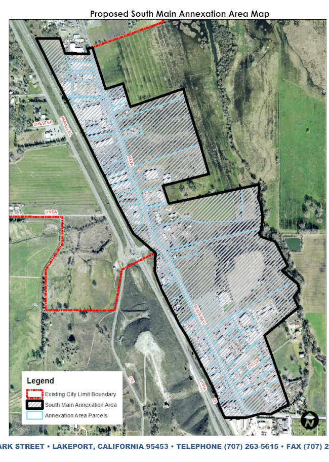
The area the city proposes to annex is approximately 137 acres, composed of 50 parcels, adjacent to South Main Street and Soda Bay Road.
It’s reported to be the most lucrative commercial area in county jurisdiction.
The city of Lakeport has long had an interest in adding the area to the city limits, having included it in its sphere of influence since at least the 1980s.
Over the past decade, the city and county have had major disagreements over Lakeport’s annexation effort.
The city had wanted to have the annexation completed in 2019, at which time county officials indicated they were not willing to give up the corridor.
In August 2019, the Lakeport City Council approved submitting an application to the Lake Local Area Formation Commission, or LAFCO. Four months later, LAFCO sent letters to the city and county to ask them to participate in a good faith process to resolve the ongoing dispute over the proposed annexation.
City and county officials said in their joint Monday statement, “Negotiations were undertaken in good faith, and focused heavily on two priorities: 1) sustainably delivering the best possible public services and governance to residents, businesses and property owners in the project area; and 2) ensuring efficient use of public funds.”
Officials said residents and businesses in the annexation area can expect improved fire protection, access to public water, emergency resiliency through installation of fire hydrants and municipal law enforcement.
The proposed draft sales tax agreement will be considered at a joint hybrid meeting of the county and city leadership at 5:30 p.m. Tuesday, Jan. 11, in the council chambers at Lakeport City Hall, 225 Park Street.
Community members are strongly urged to attend and may participate in person in the chambers or via Zoom.
The meeting can be accessed at this link.
The webinar ID is 870 8745 5679, pass code is 122127. To participate via one tap mobile, dial +12532158782,,87087455679#,,,,*122127# or +13462487799,,87087455679#,,,,*122127#.
Additional information about the annexation may be found at www.lakeportannexation.org.
Email Elizabeth Larson at
- Details
- Written by: Elizabeth Larson
The commission drew four Board of Equalization districts, 52 congressional districts, 40 Senatorial districts and 80 Assembly districts.
All districts were drawn within the permissible population deviation.
The maps can be seen here.
The commission is scheduled to meet Tuesday and give a report on the process.
Redrawing the district lines for state and federal representation occurs every 10 years based on Census data.
The 14-member commission’s work to produce new maps began in earnest earlier this year after the final Census data was released.
“We have reached the finish line for the people’s redistricting process in California. When voters approved the Voters FIRST Act, it created a monumental shift in this decennial process,” stated Commission Chair Alicia Fernandez. “As Californians, my colleagues on this commission and I answered the call to serve for this great state we honor and love. We conclude our map drawing responsibilities with pride in our final product. We started this process leaving politics out of the equation in hopes of achieving fairer and more equitable maps. I think I speak for my colleagues when I say mission accomplished! Thank you to all that participated in this process.”
The final map for congressional districts puts Lake County into one district, District 4, whereas over the past 10 years it was split between Districts 3 and 5.
The new District 4 includes all of Lake and portions of Napa, Solano, Sonoma and Yolo counties. Based on the map it also appears there is a very small portion of Sacramento County in that new district.
Congressmen John Garamendi and Mike Thompson, serving the third and fifth congressional districts, respectively, have represented Lake County over the past decade.
The new map suggests Lake County’s new district will be represented by Thompson, whose home base is Napa County.
Also on Monday night, Garamendi, who has been in Congress since 2009, announced he will run for reelection to Congress in the new Solano-North Contra Costa Eighth Congressional District.
On the state level, Lake County will be included in the new Senate District 2, which stretches along the North Coast from Marin in the south to Del Norte County in the north. The state senator for the district is expected to be Mike McGuire.
For the State Assembly, Lake will be part of District 4, which also includes Colusa, Napa and Yolo, and a portion of Sacramento County. Cecilia Aguiar-Curry, who currently represents Lake County, lives within the newly created district and also is expected to continue to represent the county.
In accordance with the California Constitution, the commission followed criteria to draw the maps, including ensuring they are of equal population to comply with the U.S. Constitution; complying with the Voting Rights Act to ensure that minorities have an equal opportunity to elect representatives of their choice; drawing districts contiguously; minimizing the division of cities, counties, neighborhoods and communities of interest to the extent possible; and making districts geographically compact.
Where practicable, the commission said each State Senate district should be composed of two complete and adjacent Assembly districts, and the Board of Equalization districts should be composed of 10 complete and adjacent State Senate districts.
The place of residence of any incumbent or political candidate may not be considered in the creation of a map, and districts may not be drawn for the purpose of favoring or discriminating against an incumbent, political candidate, or political party, the commission reported.
The California Constitution requires public comment to be taken for at least three days from the date of public display of any final statewide maps.
Additionally, the commission shall not display any other map for public comment during that period.
Email Elizabeth Larson at
- Details
- Written by: California Department of Transportation
This policy will expand the availability of sustainable transportation options to help meet the state’s climate, health and equity goals.
“California must reduce dependence on driving without sacrificing mobility and accessibility,” said Caltrans Director Toks Omishakin. “As Caltrans and local transportation agencies prepare for the influx of new federal infrastructure funding, it is important that we provide safe, convenient, sustainable and accessible alternatives to driving to achieve our climate goals while equitably serving all Californians.”
A complete street provides mobility for people of all ages and abilities, particularly those who are walking, biking, using assistive mobility devices and riding transit.
Complete streets offer several benefits, including enhancing safety and creating more sustainable transportation options to decrease dependence on driving and improving public health by encouraging active transportation like walking and biking.
As part of the new policy, Caltrans commits to remove administrative barriers and partner with communities and local agencies to ensure more projects on state and local transportation systems improve the connectivity to pedestrian, bicycle and transit facilities, and accessibility to destinations.
If not appropriate to the context or community of the project, projects must receive approval from Caltrans before complete streets features are excluded.
View the new policy here.