 How to resolve AdBlock issue?
News
In May, the Clearlake City Council voted to sell the former resort property to Bailey Building and Loans LLC, a development firm that had planned to build a resort destination there, as Lake County News has reported.
The property includes two parcels, 4.74 acres located at 14061 Lakeshore Drive and owned by the city’s redevelopment successor agency and 2.94 acres at 14071 Lakeshore Drive held by the city.
The proposed purchase price for both parcels was $915,350.
However, the COVID-19 pandemic has put a stop to the plan.
“They have stepped away from the deal at this point,” City Manager Alan Flora told Lake County News regarding the developer’s intentions.
“They were hesitant to move forward with anything early on in COVID. I am not sure if there is any chance of resurrecting the deal at this point,” he said.
At its Feb. 18 meeting, the Clearlake City Council approved two lists of surplus properties – one for city-owned properties and one held by the Clearlake Redevelopment Successor Agency – to send to the state in order to adhere to a state law that seeks to use surplus government-owned properties for affordable housing development.
The parcels at 14061 and 14071 Lakeshore Drive were included on the list, although Flora signaled at the meeting that the city wants to see the site properly developed.
He told Lake County News the same.
“We expect this to really be an impact project eventually and are confident that we can engage another partner,” he said. “I would say that we have so many other significant development projects underway right now that we are focusing all of our attention on those unless someone comes forward with a plan we like on the Austin Resort. I think we will put more energy into this one in the next one to two years when we have some of our other projects built.”
Flora noted that the city has had a couple of other people come in with an interest in doing an RV park or something at Austin Resort, “but we are not interested in seeing anything besides a quality resort development there.”
Email Elizabeth Larson at
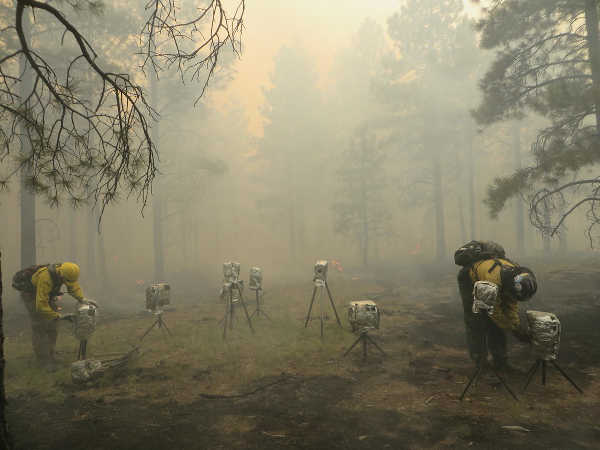
To help address growing wildfire-related challenges in America, the U.S. Geological Survey is rolling out a new Wildland Fire Science Strategy that lays out the critical needs for wildfire research over the next five years.
This strategy can be used to better understand the balance between fire’s benefits and its detrimental impacts.
Wildfires in the United States can be devastating, with 2017, 2018 and 2020 being particularly damaging and deadly years. The new fire strategy will guide future USGS research and help the agency provide timely and relevant information for land managers to tackle fire risks before they occur, during wildfire response and after the flames go out. It also addresses emerging priorities such as climate change and supporting underserved rural communities and tribes.
“Now is the time to act, and USGS science is leading the way,” said David Applegate, USGS Associate Director exercising the delegated authority of the USGS Director. “This new fire science strategy provides the roadmap for developing the research, data and technologies that are critically needed to help the country better face future wildfire challenges.”
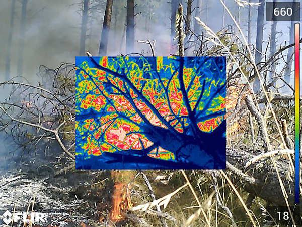
The USGS employs more than 100 scientists whose research focuses on fire-related topics, including using high-resolution remote sensing to characterize vegetative fuel loads; applying the latest satellite technology to detect fires and map wildfire perimeters; evaluating best practices to reduce wildfire risks; and assessing post-wildfire flooding and debris-flow hazards.
This work also includes creating and sharing best practices to support recovery across landscapes. Together, USGS expertise and monitoring capabilities are greatly improving the safety of first responders and the public-at-large.
The new strategy also emphasizes the importance of bridging fire and post-fire science to develop the most effective response, recovery and pre- and post-fire mitigation strategies to reduce risk. It highlights the use of computer simulations to help predict burn severity, which can then pinpoint areas that would likely be vulnerable to hazards during and after fires.
Recognizing that post-fire hazards span many branches of science, the strategy integrates different research branches to improve planning for and response to fire-related disasters.
“Cutting-edge research and multidisciplinary teamwork are key to better understanding and addressing wildfire challenges in the 21st century,” said Anne Kinsinger, Associate Director for USGS Ecosystems. “Scientists from different fields – fire ecology, hydrology, geology, remote sensing and botany – are pooling their expertise to evaluate wildfires, linking initial fire behavior to post-fire hazards and applying that information to ecosystem recovery.”
Researchers across the USGS are working with the interagency fire community to expand the use of artificial intelligence, machine learning and other rapid-computing capabilities.
For example, the USGS uses artificial intelligence with satellite imagery to detect fire boundaries and develop burn severity maps, and to identify distribution and abundance of fire-adapted invasive species like cheatgrass in the Great Basin.
“This strategy will help the local, state, tribal and federal collaboration to address the wildfire issue that our nation is experiencing,” said Jeff Rupert, director of the Department of the Interior’s Office of Wildland Fire. “The science needs identified in the strategy will support firefighters that respond to wildfires and prevention efforts to protect communities, resources and people.”
For example, the USGS is partnering with the Los Alamos National Laboratory and Tall Timbers Research Station to model fire behavior, fire weather patterns, 3D fuel loads and smoke conditions to evaluate how fuel treatments can reduce fire risk across a changing landscape.
The USGS is also strengthening its partnerships with the Fire Science Exchange Network to foster increased access and use of its fire information, data and tools while learning about needs of practitioners in the field.
The USGS Wildland Fire Science Strategy aligns with national initiatives as defined in the National Cohesive Wildland Fire Management Strategy. Developed by a broad swath of stakeholders at all levels, the Cohesive Strategy calls for science and management that promote resilient landscapes and fire-adapted communities for safe and effective wildfire responses.
For more details about the new USGS Wildland Fire Science 2021-2026 Strategic Plan, read the full report.
For more information about USGS fire science, visit www.usgs.gov/fire.
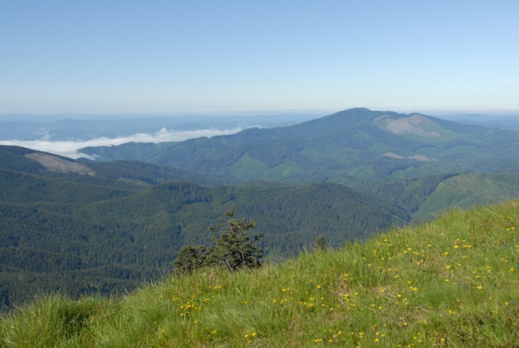
Protecting forests is an essential strategy in the fight against climate change that has not received the attention it deserves. Trees capture and store massive amounts of carbon. And unlike some strategies for cooling the climate, they don’t require costly and complicated technology.
Yet although tree-planting initiatives are popular, protecting and restoring existing forests rarely attracts the same level of support. As an example, forest protection was notably missing from the US$447 million Energy Act of 2020, which the U.S. Congress passed in December 2020 to jump-start technological carbon capture and storage.
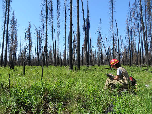
In our work as forest carbon cycle and climate change scientists, we track carbon emissions from forests to wood products and all the way to landfills – and from forest fires. Our research shows that protecting carbon in forests is essential for meeting global climate goals.
Ironically, we see the U.S. Strategic Petroleum Reserve as a model. This program, which was created after the 1973 oil crisis to guard against future supply disruptions, stores nearly 800 million gallons of oil in huge underground salt caverns along the coast of the Gulf of Mexico. We propose creating strategic forest carbon reserves to store carbon as a way of stabilizing the climate, much as the Strategic Petroleum Reserve helps to stabilize oil markets.
Carbon stockpiles that grow
Forests pull about one-third of all human-caused carbon dioxide emissions from the atmosphere each year. Researchers have calculated that ending deforestation and allowing mature forests to keep growing could enable forests to take up twice as much carbon.
Half of a tree’s stems, branches and roots are composed of carbon. Live and dead trees, along with forest soil, hold the equivalent of 80% of all the carbon currently in Earth’s atmosphere.
Trees accumulate carbon over extremely long periods of time. For example, redwoods, Douglas firs and western red cedars in the coastal forests of the Pacific Northwest can live for 800 years or more. When they die and decompose, much of that carbon ends up in soil, where it is stored for centuries or millennia.
Mature trees that have reached full root, bark and canopy development deal with climate variability better than young trees. Older trees also store more carbon. Old-growth trees, which usually are hundreds of years old, store enormous quantities of carbon in their wood, and accumulate more carbon annually.

There are many fallacies about forest carbon storage, such as the concern that wildfires in the American West are releasing huge quantities of carbon into the atmosphere. In fact, fires are a relatively small carbon source. For example, the massive Biscuit Fire, which burned 772 square miles in southwest Oregon in 2002, emitted less than 10% of Oregon’s total emissions that year.
Another false claim is that it’s OK from a climate perspective to cut trees and turn them into furniture, plywood and other items because wood products can store substantial amounts of carbon. These assertions fail to count cradle-to-grave emissions from logging and manufacturing, which can be substantial.
The wood products industry releases carbon in many ways, from manufacturing products and burning mill waste to the breakdown of short-lived items like paper towels. It takes decades to centuries for newly planted forests to accumulate the carbon storage levels of mature and old forests, and many planted forests are repeatedly harvested.
In a review that we conducted with colleagues in 2019, we found that overall, U.S. state and federal reporting underestimated wood product-related carbon dioxide emissions by 25% to 55%. We analyzed Oregon carbon emissions from wood that had been harvested over the past century and discovered that 65% of the original carbon returned to the atmosphere as CO2. Landfills retained 16%, while just 19% remained in wood products.
In contrast, protecting high carbon-density western U.S. forests that have low vulnerability to mortality from drought or fire would sequester the equivalent of about six years of fossil fuel emissions from the entire western U.S., from the Rocky Mountain states to the Pacific coast.

Focus on big trees
In a recently published analysis of carbon storage in six national forests in Oregon, we showed why a strategic forest carbon reserve program should focus on mature and old forests. Big trees, with trunks more than 21 inches in diameter, make up just 3% of these forests but store 42% of the above-ground carbon. Globally, a 2018 study found that the largest-diameter 1% of trees hold half of all the carbon stored in the world’s forests.
Findings like these are spurring interest in the idea of proforestation – keeping existing forests intact and letting them grow to their full potential. Advocates see proforestation as an effective, immediate and low-cost strategy to store carbon. Older forests are more resilient to climate change than young tree plantations, which are more susceptible to drought and severe wildfires. Like the 2,000-year-old redwoods in California that have survived recent wildfires, many tree species in old forests have lived through past climate extremes.
Creating forest carbon reserves would also conserve critical habitat for many types of wildlife that are threatened by human activities. Connecting these reserves to other parks and refuges could help species that need to migrate in response to climate change.
Using forests to meet climate goals
More than half of U.S. forested lands are privately owned, so strategic forest carbon reserves should be established on both public and private lands. The challenge is paying for them, which will require a major shift in government and societal priorities. We believe that transferring public investment in oil and gas subsidies to pay private land owners to keep their forests growing could act as a powerful incentive for private land owners.
Many researchers and conservation advocates have called for comprehensive actions to slow climate change and reduce species losses. One prominent example is the 30x30 initiative, which seeks to conserve 30% of the world’s land and oceans by 2030. In an executive order on Jan. 27, 2021, President Biden directed his administration to develop plans for conserving at least 30% of federally controlled lands and waters by 2030.
Recent projections show that to prevent the worst impacts of climate change, governments will have to increase their pledges to reduce carbon emissions by as much as 80%. We see the next 10 to 20 years as a critical window for climate action, and believe that permanent protection for mature and old forests is the greatest opportunity for near-term climate benefits.
[The Conversation’s science, health and technology editors pick their favorite stories. Weekly on Wednesdays.]![]()
Beverly Law, Professor Emeritus of Global Change Biology and Terrestrial Systems Science, Oregon State University and William Moomaw, Professor Emeritus of International Environmental Policy, Tufts University
This article is republished from The Conversation under a Creative Commons license. Read the original article.
Dogs available for adoption this week include mixes of boxer, Chihuahua, German Shepherd, Labrador Retriever, pit bull and pug.
Dogs that are adopted from Lake County Animal Care and Control are either neutered or spayed, microchipped and, if old enough, given a rabies shot and county license before being released to their new owner. License fees do not apply to residents of the cities of Lakeport or Clearlake.
The following dogs at the Lake County Animal Care and Control shelter have been cleared for adoption (additional dogs on the animal control Web site not listed are still “on hold”).
Call Lake County Animal Care and Control at 707-263-0278 or visit the shelter online at http://www.co.lake.ca.us/Government/Directory/Animal_Care_And_Control.htm for information on visiting or adopting.

Boxer-pit bull terrier mix
This female boxer-pit bull mix has a short red coat.
She is in kennel No. 18, ID No. 14356.

Female pit bull terrier
This female pit bull terrier has a short red coat.
She is in kennel No. 20, ID No. 14367.

Male pit bull terrier
This male pit bull terrier has a short brindle and white coat.
He is in kennel No. 26, ID No. 14339.

Female Chihuahua-pug mix
This female Chihuahua-pug mix has a long black and brown coat.
She is in kennel No. 29, ID No. 14375.
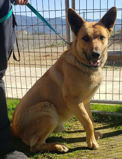
German Shepherd-Labrador Retriever mix
This male German Shepherd-Labrador Retriever mix has a short black and tan coat.
He is in kennel No. 31, ID No. 14383.
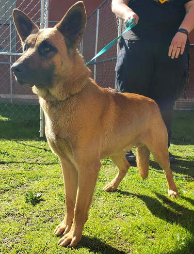
German Shepherd-Labrador Retriever mix
This male German Shepherd-Labrador Retriever mix has a short black and tan coat.
He is in kennel No. 32, ID No. 14382.

Female Chihuahua
This female Chihuahua has a short brown and gray coat.
She has been spayed.
She’s in kennel No. 33, ID No. 14368.
Email Elizabeth Larson at
This video takes the viewer on a trip through the Milky Way Galaxy toward Earth, flying through a 6,000-light-year-diameter cloud of more than 1 million binary stars mapped by UC Berkeley’s Kareem El-Badry. After reaching Earth, the video switches to a view into the future as pairs of binary stars move through space. (UC Berkeley video by Roxanne Makasdjian, based on animation by Jackie Faherity, AMNH, and data by Kareem El-Badry.)
The latest star data from the Gaia space observatory has for the first time allowed astronomers to generate a massive 3D atlas of widely separated binary stars within about 3,000 light years of Earth — 1.3 million of them.
The one-of-a-kind atlas, created by Kareem El-Badry, an astrophysics Ph.D. student from the University of California, Berkeley, should be a boon for those who study binary stars — which make up at least half of all sunlike stars — and white dwarfs, exoplanets and stellar evolution, in general.
Before Gaia, the last compilation of nearby binary stars, assembled using data from the now-defunct Hipparcos satellite, included about 200 likely pairs.
“This is just a massive increase in sample size,” said El-Badry. “And it is an increase in what kinds of evolutionary phases we find the binaries in. In our sample, we have 17,000 white dwarfs alone. This is a much bigger census.”
White dwarfs are the end stages of most stars; the sun will likely end up as a compact white dwarf in 5 billion years. El-Badry’s atlas includes 1,400 systems that consist of two white dwarfs and 16,000 binaries that consist of a white dwarf and another type of star
The vast majority of the 2.6 million individual stars are still in the prime of life, however. Astronomers refer to them as main sequence stars, because they cluster along a line when plotted on a graph showing temperature versus brightness.
With such a large sample size, El-Badry said, it’s possible to do population demographics of these stellar twins, asking questions such as: What is the distribution of mass ratios of the two stars in all these binary systems? How are their separations or eccentricities distributed?
El-Badry plans to focus in the future on the white dwarf binaries, because white dwarfs can be assigned an age more precisely than is possible with regular stars. Main sequence stars like the sun can look the same for billions, or even tens of billions, of years, while white dwarfs change — for one thing, they cool down at a well-defined rate. And since binary pairs are birthed at the same time, the age of the white dwarf tells astronomers the age of its main-sequence twin, or of any planets around the stars.
“For a white dwarf, in general, it is easy to tell how old it is — not just how old since it became a white dwarf, but what its total age is,” he said. “You can also measure their masses, because white dwarfs have a well-understood mass-radius relation.”
As an example, El-Badry and colleagues recently used the Gaia data to estimate the age of a Jupiter-sized gas giant discovered by the TESS satellite around a white dwarf-K dwarf pair. That exoplanet, TOI-1259Ab, turned out to be about 4 billion years old, based on the age of the white dwarf.
“In this catalog, there are something like 15 systems like this: star plus planet plus white dwarf,” he said, “and there are another few hundred that are star plus planet plus another star. Those are also potentially interesting because, in some cases, the other star will do something dynamically to the planet.”
The new catalog of nearby binary stars has been accepted for publication in the journal Monthly Notices of the Royal Astronomical Society.
El-Badry also collaborated with Jackie Faherity, a scientist and educator at the American Museum of Natural History in New York City, to create a video fly-through of all the million binary stars around Earth, which represents a good chunk of the entire Milky Way Galaxy.
Binary stars
Until Gaia was launched by the European Space Agency in 2013 to precisely measure the distances and motions of millions of nearby stars, the only way to find binaries was to look for stars close together in the sky. This can be tricky, because stars that look very close from Earth could be hundreds to thousands of light-years from one another, merely sitting along the same line of site.
Ruling out a chance alignment requires lots of observing time to confirm that the two candidates are actually at the same distance and moving together. Because of Earth’s motion around the sun, nearby stars appear to change position in the sky, and that parallax can be used to calculate how far away they are. The star’s motion across the sky, known as proper motion, helps determine its velocity.
Gaia conducts this tedious astrometry continuously for all nearby stars in the sky, 24/7, from its orbit at the Earth-Sun Lagrange point. The space telescope’s survey is most useful for stars within about 3,000 light years of Earth, however, because beyond that, the parallax is usually too small to measure.
El-Badry first looked for binary stars in Gaia data after the mission’s second release of star measurements in 2018, with the help of colleagues Hans-Walter Rix, director of the Max-Planck Institute for Astronomy in Heidelberg, Germany, and Tyler Heintz, a graduate student at Boston University.
They developed computational techniques to identify stars moving together through space and at the same distance from Earth. The technique basically projects each star’s movement over thousands of years, based on its proper motion today, and pulls out stars that are moving in the same direction. If they also turn out to be at the same distance based on parallax, they’re probably bound to one another, he said.
He and his colleagues focus primarily on wide-binaries — those separated by a distance of 10 AU (astronomical units) or more — that is, 10 or more times the distance between Earth and the sun (93 million miles). Stars closer than that typically appear as one point of light and require other spectroscopic techniques to distinguish whether they are true binaries.
To get first crack at Gaia’s latest data, El-Badry arose at 3 a.m. on the release date, Dec. 3 of last year, and joined some 100 other astronomers from around the world on Zoom. He quickly ran pre-programmed queries on the data to extract the catalog information he needed to create the 3D map.
The initial queries returned some 1.8 million binary candidates from Gaia’s catalog of 1.8 billion stars, so El-Badry first had to assess the likelihood that some of the pairs were at the same distance and moving in similar directions just by chance, not because they are paired. He estimates that nearly 1.3 million pairs had at least a 90% chance of being bound, and 1.1 million had a 99% chance.
“About half of all sun-like stars are binaries, many of them too close to distinguish, but we find something like 25% of all sun-like stars have a binary companion at separations of more than 30 AU, about the distance to Pluto,” he said. “The distribution peaks at a separation of 30 or 50 AU.”
Some pairs are separated by as much as a parsec — 260,000 AU, or 3.26 light-years — though most are within 1,000 AU of one another.
One takeaway, he said, is that the new analysis confirms something hinted at in the 2018 data: Many binary star pairs are very similar in mass.
“One thing we already found that is cool — we discovered this with Gaia DR2, but now we can study it better with this sample — is that binaries like to be identical twins,” he said. “That is really weird, because most of these are separated by hundreds or thousands of AU, so they are so far apart that, by conventional star formation theories, their masses should be random. But the data tells a different story: They know something about their companions’ masses.”
The implication, he said, is that they formed much closer together in a process that tended to equalize their masses and then migrated apart, perhaps because of interactions with other nearby stars.
The compilation of binary stars also allowed El-Badry to check the reported uncertainties in Gaia’s measurements of stellar positions, which can assist other researchers who use the data.
Robert Sanders writes for the UC Berkeley News Center.
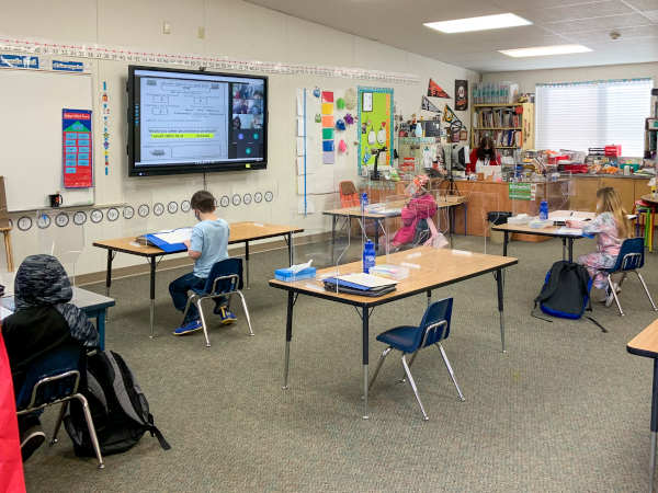
LAKE COUNTY, Calif. – On Monday, the Konocti Unified School District brought elementary school students back onto school campuses in a hybrid model, allowing for social distancing with only about half of the students in the classroom at any given time.
What makes their return to in-person instruction unusual is the technology Konocti Unified has employed to connect the students at home with the students on campus.
“One of the reasons classroom-based learning is so powerful is the connection and interaction with others, so at Konocti Unified, we invested in technology that allows real-time interaction among students and between students and teachers,” said Konocti Unified School District Superintendent Dr. Becky Salato. “Now, even when students are learning remotely, they’ll be getting the same instruction at the same time, and they’ll be able to ask questions and participate rather than having to catch-up later.”
When the pandemic hit, it became clear to Salato that the need for remote instruction could extend beyond the current crisis.
In response, Konocti Unified purchased video cameras, microphones, large screens and the software required to facilitate interactivity for every classroom, TK-12, districtwide.
“Not only will this allow for the most engagement during the hybrid model, but it enables us to leap into the future of education, to provide more engagement and access for all students,” Salato said.
She explained that in the past, when students could not attend class for extended periods of time, they often fell behind, as in the case of a student on home hospital leave.
Salato noted that a one-hour visit once a week from an instructor was a poor substitute for daily class participation. With this new technology, a home-bound student could participate in class without putting their medical recovery at risk.
“It’s clear that after the pandemic ends we’ll continue to see barriers that prevent equal access to instruction. Now, we have a tool to reduce those barriers,” Salato said.
As students return to school campuses this week and in the weeks to come, Konocti Unified is using technology both to enhance academic instruction and to keep students and staff safe.
All students and staff are required to complete a self-evaluation via their cell phone or Chromebook to answer screening questions regarding potential COVID-19 exposure or symptoms before being allowed on campus. This reduces the risk of infection and prevents long waits at the gate when everyone arrives at school.
Elementary schools are open in the hybrid model now and secondary schools will open when Lake County Public Health gives Konocti Unified the green light, likely when Lake County drops from the purple tier to the red tier in the state’s Blueprint for a Safer Economy. That tier change will indicate the spread of COVID-19 has slowed in the community.
KUSD’s extensive safety measures either meet or exceed state and local public health requirements.
In addition to daily self-evaluations for COVID-19 exposure and symptoms, safety measures include mask-wearing and social distancing, no mixing of cohorts, and strict navigational pathways through campuses to reduce face-to-face contact.
Principals also sent videos to student families explaining what to expect upon their return to school, including instructions on how to wash hands and wear masks properly.
“We’ve painted arrows, so students know which direction to go and we have marked spots six feet apart, so they know where to stand before entering their classroom,” Salato explained.
For bus transportation, fewer students are allowed on the buses so children can be safely distanced, masks are required, and windows are open at all times.
On campuses, bathrooms are designated for specific classrooms and are sanitized regularly, and at the end of the day, students receive a grab-and-go lunch rather than eating on campus.
In addition, Konocti Unified provides COVID-19 testing for staff and, with parent permission, students, including both surveillance testing and symptomatic testing.
Based on Public Health guidelines while Lake County is in the purple tier, surveillance testing is offered every other week.
If a student or staff member shows symptoms, a quick-turnaround test is available with results in 15 minutes.
Finally, all Konocti Unified employees interested in being vaccinated have received their first dose and more than half have already received their second dose.
“Families who prefer full-time distance learning can continue to receive all their instruction online, but the overwhelming response from most families has been relief and joy for their children to be allowed to see friends and interact with their teachers in person,” Salato said.