 How to resolve AdBlock issue?
News

On Monday, Gov. Jerry Brown Jr. joined Attorney General Xavier Becerra to present the Public Safety Officer Medal of Valor to five public safety leaders from the California Highway Patrol and the Yuba County Sheriff’s Department who went above and beyond the call of duty.
“American democracy is not going to work if it's just based on self-interest or people trying to get what they want. It's also based on serving a much higher ideal,” said Gov. Brown. “Men and women in uniform demonstrate that more than anyone – and that's why we have a medal of valor and honor these individuals today.”
The Public Safety Officer Medal of Valor Act of 2003 gives the governor authority to award medals to public safety officers who are recognized by the attorney general for extraordinary valor above and beyond the call of duty.
The Attorney General’s Office receives nominations from public safety agencies. These nominations are reviewed by the Medal of Valor Review Board, which makes a recommendation to the attorney general.
"The officers we recognized today with the Governor's Medal of Valor courageously put public safety before their own safety," said Attorney General Becerra. "They put themselves in harm's way every day to protect Californians across the state. For this, we are forever thankful."
The following individuals were awarded the Public Safety Officer Medal of Valor.
Yuba County Sheriff’s Department: Deputy Sheriff Dan Harris
On Aug. 1, 2017, Deputy Phillip Bronson and Deputy Andrew Everhart responded to a disturbance call involving two subjects associated with illegal activity, one of whom was said to have brandished a weapon. The location of the call was a remote residence and the site of illegal marijuana cultivation.
Upon arrival, the deputies confirmed that one subject was in possession of a handgun and a foot pursuit began as the suspect fled the deputies. While in pursuit, the deputies broadcasted for additional assistance.
Deputy Dan Harris, who was on duty, responded to the call although he was not assigned as a patrol deputy that day. Instead his assignment was with the Department’s Marine Enforcement, patrolling the waterways in Yuba County in a boat, dressed in shorts and a polo shirt.
When Deputy Harris arrived on scene and met with Deputies Bronson and Everhart, they had established a perimeter around a nearby residence that they believed the suspect had entered. They agreed to have Deputy Harris provide cover at the exterior of the residence because he did not have a ballistic vest in his possession.
When Deputies Bronson and Everhart entered the residence, the suspect, armed with a .40 caliber handgun, began shooting at them from behind a closed door. The suspect continued to shoot as he exited the room. Deputies Bronson and Everhart returned fire. Both deputies were each struck by gunfire three times and the suspect was also struck multiple times. The deputies broadcasted over the radio that shots were fired and they were injured.
Deputy Harris, armed with a handgun, entered the residence to assist the deputies. Deputy Harris found Deputies Bronson and Everhart seriously injured. They still had not located the suspect, although he was fatally wounded inside the same room. Deputy Harris helped Deputy Everhart outside of the residence and reentered to go to Deputy Bronson’s aid. Deputy Harris pulled Deputy Bronson from the residence, as he was unable to walk due to his injuries.
Without regard to his own personal safety, Deputy Harris began providing life-saving measures to both deputies, while also updating the sheriff’s dispatch and responding units with critical information.
Deputies Bronson and Everhart were airlifted to an area hospital for treatment and are both still in recovery.
For Deputy Harris’ extraordinary bravery, heroism and courage in the face of imminent and personal life threatening peril, his actions went above and beyond the call of duty and exemplified the highest standards of a California public safety officer.
California Highway Patrol: Officer Phil Agdeppa, Officer Pete Gavitte, Officer Whitney Lowe and Officer Chad Millward
On Oct. 8, 2017, a CHP officer with Golden Gate Air Operations was returning to the Napa County Airport from a surveillance flight and observed a “glow” northeast of Napa – a quickly growing wildfire covering approximately 10 acres. The officer notified the dispatch, who then notified Cal Fire.
CHP Officers Pete Gavitte and Whitney Lowe, also with Golden Gate Air Operations, monitored the call and responded to the Atlas Peak area of Sonoma County.
Upon arriving, they observed smoke-filled air and a towering wall of flames more than a mile long. They noticed that numerous residents were trapped between the fire and the hillsides. Due to the location of the fire and its rapid increasing size, many residents of the Atlas Peak area were trapped above the fire line.
The Golden Gate Air Operations crew monitored radio traffic from CalFire calling for evacuations, but as Cal Fire resources were unable to reach the Atlas Peak residents, Officers Gavitte and Lowe used the helicopter’s public address system, siren and searchlight to alert the sleeping residents.
Officers Gavitte and Lowe recognized that the only escape for the Atlas Peak residents would be by helicopter rescue.
Despite the firestorm’s 80-mile per hour wind gusts and extreme downdrafts and updrafts, the officers decided to fly into the smoke and land near the line of vehicles attempting to leave the Atlas Peak area. The helicopter only held four people at a time and the officers realized additional assistance would be necessary. They requested help from CHP Northern Division Air Operations and Officers Chad Millward and Phil Agdeppa responded to the call.
The two helicopter crews began coordinating rescues and identifying drop-off locations as fires continuously overran the landing zones, together saving 41 lives. Aerial surveillance from the night of the rescues shows the rescue area was completely overrun by fire.
For their extraordinary bravery, heroism, and courage in the face of imminent and personal life threatening peril, their actions went above and beyond the call of duty and exemplify the highest standard of a California public safety officer.
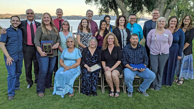
KELSEYVILLE, Calif. – The Lake County Office of Education honored several local educators whose work has made an impact in the lives of students and the community at large.
The 24th annual Lake County Educator of the Year Awards Dinner on Saturday, Oct. 20, at Buckingham Clubhouse in Kelseyville.
Administrators and teachers from five of the six Lake County schools districts and the Lake County Office of Education, or LCOE, presented commendations to the honorees on behalf of the honoree’s district, LCOE, Congressman Mike Thompson and Congressman John Garamendi.
The California Department of Education recently selected Lake County Teacher of the Year, Erica Boomer, who teaches agriculture at Upper Lake High School, as one of five California Teachers of the Year.
LCOE acknowledged Boomer with a plaque. Jessica Stillman of Community First Credit Union presented Boomer with a check for $1,500.
Boomer competed with four other Lake County teachers for the title of Lake County Teacher of the Year in May 2018, representing Upper Lake Unified School District. She then represented Lake County at the California Teacher of the Year competition, leading to her recognition as one of the top educators in the state of California.
Lake County Superintendent of Schools Brock Falkenberg, recognized Sarah Fuchs, athletic director at Lower Lake High School, as the “Lake County Champion of Education” for her work in organizing the opening of the Lower Lake High School shelter during the Mendocino Complex fire in July and August.
“Sarah led the effort to open Lower Lake High School as an evacuation shelter,” said Falkenberg. “Due to several fires in other parts of the state and nation, staffing from support organizations was not immediately available. Sarah had the courage to step up and coordinate a team of volunteers consisting of school staff, parents, and students to operate the shelter until support staffing could be mobilized.”
Falkenberg added, “Under Sarah’s leadership the shelter swelled to a population of over 850 evacuees, the largest evacuation center ever operated in Lake County. Sarah is an outstanding example of Lake County educators stepping up to take leadership roles to meet our community’s needs.”
The 2018 Lake County Educator of the Year Honorees include:
1. Erica Boomer, Upper Lake High School, Lake County and California Teacher of the Year
2. Traci Snider, Upper Lake Unified Classified Employee of the Year
3. Keely Antoni, Kelseyville Unified Teacher of the Year
4. Bonnie Hoeck, Kelseyville Unified Classified Employee of the Year
5. Kathleen Hayes, Konocti Unified Teacher of the Year
6. Olivia Jaramillo-Campos, Konocti Unified Classified Employee of the Year
7. Ana Goff, Lakeport Unified Teacher of the Year
8. Schad Schweitzer, Lakeport Unified Classified Employee of the Year
9. Joel Miller, Lake County Office of Education Classified Employee of the Year
10. Shaun Roderick, Middletown Unified Teacher of the Year
11. Sarah Fuchs, Lake County Champion of Education
Jennifer Kelly, science teacher from Middletown High School and Alan Siegel, social science/media teacher at Carlé Continuation High School in Clearlake were also on hand.
Kelly and Siegel were previous Lake County Teachers of the Year, who were recognized as California Teachers of the Year by the California Department of Education.
Community First Credit Union and Steele Wines were sponsors of the event.
The California Department of Education will honor Boomer as a California Teacher on Dec. 10 in Sacramento. Kelly and Siegel also be be attending the state event in December.
LAKEPORT, Calif. – District Attorney Don Anderson said his investigation into a man’s death in police custody this spring has concluded that the cause was a drug overdose.
Anderson released his findings on Sunday in the death of 24-year-old Anthony Gerard Cortez of Clearlake.
Cortez died on May 30 shortly after Lakeport Police officers had taken him into custody, as Lake County News has reported.
In its initial report, the Lakeport Police Department said officers had responded to the Anchorage Inn on N. Main Street on a report of a shirtless male subject acting erratically, running around the parking lot and banging on the glass door, and then walking down the middle of Main Street and stopping traffic.
The officers located Cortez on the ground in front of the old Natural High School property in the 800 block of N. Main Street, where they said he was flailing n the ground. When they approached, he got up and began walking toward them, flailing his arms and acting paranoid.
The Lakeport Police Department said the officers took control of Cortez, placed him in handcuffs, sat him on the ground and then – based on his behavior – requested medical assistance.
When paramedics arrived, police said Cortez was placed on a gurney and taken to the ambulance. Once in the vehicle, he began to have a medical emergency – going into cardiac arrest – and was transported to Sutter Lakeside Hospital while paramedics attempted to save him, according to the report.
At the hospital, medical personnel continued to try to save Cortez’s life, but police said he died a short time after he arrived.
Anderson said his office’s investigation was initiated in accordance with the Lake County Critical Incident Protocol of 2016.
He said an autopsy determined that Cortez suffered no obvious trauma and that his death was caused by acute drug toxicity and acute amphetamine overdose.
“The officers at Lakeport Police Department acted professionally and well within the bounds of police procedures and policy. The officers placing Anthony Cortez in handcuffs was well within reason and accepted police protocol based on the officers observed conduct of Cortez and the reported history,” Anderson wrote. “Therefore, it is the findings of this office that the death of Anthony Gerard Cortez was the result of a drug overdose and was not contributed to, or caused by any member of the Lakeport Police Department.”
Anderson’s full report is published below.
Email Elizabeth Larson atThis email address is being protected from spambots. You need JavaScript enabled to view it. . Follow her on Twitter, @ERLarson, or Lake County News, @LakeCoNews.
INTRODUCTION
On May 30, 2018 at about 10:08 a.m., officers of the Lakeport Police Department detained Anthony Gerard Cortez at the Natural High School, 950 North Main Street, Lakeport, California based on reports of unusual activity being exhibited by Mr. Cortez.
Anthony Cortez exhibited signs of having a medical distress. Lakeport Fire Department responded and transported Mr. Cortez to Sutter Lakeside Hospital. At 11:14 a.m. Mr. Cortez was pronounced dead, 14 minutes after arriving at the hospital.
Pursuant to the Lake County Critical Incident Protocol of 2016, the Lake County District Attorney’s Office conducted the investigation into the incident. This report and findings are conducted pursuant to California State law as well as the Lake County Law Enforcement Critical Incident Protocol.
It is the finding of the Lake County District Attorney’s Office that Anthony Gerard Cortez died as a result of a drug overdose. It is further our finding that Lakeport Police officers acted appropriately in their care of Mr. Cortez and made every effort to save his life. No wrong doings have been found and there shall be no criminal charges filed on any individual in this matter
FACTS
Below is a chronological history of the events of May 30, 2018. Most of the events were captured on video surveillance and police audio and video cameras.
At 10:01 a.m. Cortez exits room 205 at the Anchorage Inn. He is seen running back and forth on the walkway on the second floor balcony. He is barefoot with no shirt and only wearing pants. He is yelling at occupants and gesturing wildly. He appears agitated and is waving his arms. Cortez walks down the stairs and continues his wild, out of control conduct in the parking lot. A few minutes later Cortez walks onto Main Street and walks south bound in the middle of the road.
At 10:02 a.m. several calls are made to the police department and 911 dispatch.
At 10:08 a.m. Chief Brad Rasmussen and Office Andrew Welter contact Anthony Cortez who is sitting on the grass area on the west side of the Old Natural High School. As the officers approach, Cortez stands to his feet and approached the officers. Cortez did not appear hostile to the officers but showed sign of agitation and erratic behavior. Cortez was mumbling, waving his arms bobbing, dancing in place and shaking his head. The officers immediately placed handcuffs on Cortez and sat him back down. While on the ground Cortez continued his agitated state, kicking his feet.
At 10:13 a.m. Lakeport Fire Department arrives at the scene. At this time it is noted that Cortez is in a state of cardiac arrest.
At 10:49 a.m. Lakeport Fire Department starts transporting Cortez to Sutter Lakeside Hospital.
At 10:56 a.m. Lakeport Fire Department arrived at Sutter Lakeside Hospital.
At 11:13 a.m. Anthony Cortez is pronounced dead by a physician at Sutter Lakeside Hospital.
Investigators from the District Attorney’s Office conducted a search of room 205 at the Anchorage Inn. No narcotics are located; however two empty syringes are found within the room.
On May 31, 2018, an autopsy was conducted on Anthony Cortez by Bennet Omalu. Dr. Bennet I. Omalu determines the cause of death to be acute drug toxicity and acute amphetamine overdose. The report notes there are no obvious trauma on Anthony Cortez.
In a report dated June 18, 2018, Central Valley Toxicology reports a specimen of Anthony Cortez contained Atopine = 0.32 mg/L, d-Methamphetamine = 9.6 mg/L and d-Amphetamine = 0.05 mg/L.
FINDINGS
It is the findings of the Lake County District Attorney’s Office that Anthony Gerard Cortez died as a result of a drug overdose as set forth above.
The officers at Lakeport Police Department acted professionally and well within the bounds of police procedures and policy. The officers placing Anthony Cortez in handcuffs was well within reason and accepted police protocol based on the officers observed conduct of Cortez and the reported history.
Therefore, it is the findings of this office that the death of Anthony Gerard Cortez was the result of a drug overdose and was not contributed to, or caused by any member of the Lakeport Police Department.
_____________________________
Don A. Anderson
Lake County District Attorney
Anderson released his findings on Sunday in the death of 24-year-old Anthony Gerard Cortez of Clearlake.
Cortez died on May 30 shortly after Lakeport Police officers had taken him into custody, as Lake County News has reported.
In its initial report, the Lakeport Police Department said officers had responded to the Anchorage Inn on N. Main Street on a report of a shirtless male subject acting erratically, running around the parking lot and banging on the glass door, and then walking down the middle of Main Street and stopping traffic.
The officers located Cortez on the ground in front of the old Natural High School property in the 800 block of N. Main Street, where they said he was flailing n the ground. When they approached, he got up and began walking toward them, flailing his arms and acting paranoid.
The Lakeport Police Department said the officers took control of Cortez, placed him in handcuffs, sat him on the ground and then – based on his behavior – requested medical assistance.
When paramedics arrived, police said Cortez was placed on a gurney and taken to the ambulance. Once in the vehicle, he began to have a medical emergency – going into cardiac arrest – and was transported to Sutter Lakeside Hospital while paramedics attempted to save him, according to the report.
At the hospital, medical personnel continued to try to save Cortez’s life, but police said he died a short time after he arrived.
Anderson said his office’s investigation was initiated in accordance with the Lake County Critical Incident Protocol of 2016.
He said an autopsy determined that Cortez suffered no obvious trauma and that his death was caused by acute drug toxicity and acute amphetamine overdose.
“The officers at Lakeport Police Department acted professionally and well within the bounds of police procedures and policy. The officers placing Anthony Cortez in handcuffs was well within reason and accepted police protocol based on the officers observed conduct of Cortez and the reported history,” Anderson wrote. “Therefore, it is the findings of this office that the death of Anthony Gerard Cortez was the result of a drug overdose and was not contributed to, or caused by any member of the Lakeport Police Department.”
Anderson’s full report is published below.
Email Elizabeth Larson at
FINAL REPORT
IN CUSTODY DEATH OF ANTHONY GERARD CORTEZ
INTRODUCTION
On May 30, 2018 at about 10:08 a.m., officers of the Lakeport Police Department detained Anthony Gerard Cortez at the Natural High School, 950 North Main Street, Lakeport, California based on reports of unusual activity being exhibited by Mr. Cortez.
Anthony Cortez exhibited signs of having a medical distress. Lakeport Fire Department responded and transported Mr. Cortez to Sutter Lakeside Hospital. At 11:14 a.m. Mr. Cortez was pronounced dead, 14 minutes after arriving at the hospital.
Pursuant to the Lake County Critical Incident Protocol of 2016, the Lake County District Attorney’s Office conducted the investigation into the incident. This report and findings are conducted pursuant to California State law as well as the Lake County Law Enforcement Critical Incident Protocol.
It is the finding of the Lake County District Attorney’s Office that Anthony Gerard Cortez died as a result of a drug overdose. It is further our finding that Lakeport Police officers acted appropriately in their care of Mr. Cortez and made every effort to save his life. No wrong doings have been found and there shall be no criminal charges filed on any individual in this matter
FACTS
Below is a chronological history of the events of May 30, 2018. Most of the events were captured on video surveillance and police audio and video cameras.
At 10:01 a.m. Cortez exits room 205 at the Anchorage Inn. He is seen running back and forth on the walkway on the second floor balcony. He is barefoot with no shirt and only wearing pants. He is yelling at occupants and gesturing wildly. He appears agitated and is waving his arms. Cortez walks down the stairs and continues his wild, out of control conduct in the parking lot. A few minutes later Cortez walks onto Main Street and walks south bound in the middle of the road.
At 10:02 a.m. several calls are made to the police department and 911 dispatch.
At 10:08 a.m. Chief Brad Rasmussen and Office Andrew Welter contact Anthony Cortez who is sitting on the grass area on the west side of the Old Natural High School. As the officers approach, Cortez stands to his feet and approached the officers. Cortez did not appear hostile to the officers but showed sign of agitation and erratic behavior. Cortez was mumbling, waving his arms bobbing, dancing in place and shaking his head. The officers immediately placed handcuffs on Cortez and sat him back down. While on the ground Cortez continued his agitated state, kicking his feet.
At 10:13 a.m. Lakeport Fire Department arrives at the scene. At this time it is noted that Cortez is in a state of cardiac arrest.
At 10:49 a.m. Lakeport Fire Department starts transporting Cortez to Sutter Lakeside Hospital.
At 10:56 a.m. Lakeport Fire Department arrived at Sutter Lakeside Hospital.
At 11:13 a.m. Anthony Cortez is pronounced dead by a physician at Sutter Lakeside Hospital.
Investigators from the District Attorney’s Office conducted a search of room 205 at the Anchorage Inn. No narcotics are located; however two empty syringes are found within the room.
On May 31, 2018, an autopsy was conducted on Anthony Cortez by Bennet Omalu. Dr. Bennet I. Omalu determines the cause of death to be acute drug toxicity and acute amphetamine overdose. The report notes there are no obvious trauma on Anthony Cortez.
In a report dated June 18, 2018, Central Valley Toxicology reports a specimen of Anthony Cortez contained Atopine = 0.32 mg/L, d-Methamphetamine = 9.6 mg/L and d-Amphetamine = 0.05 mg/L.
FINDINGS
It is the findings of the Lake County District Attorney’s Office that Anthony Gerard Cortez died as a result of a drug overdose as set forth above.
The officers at Lakeport Police Department acted professionally and well within the bounds of police procedures and policy. The officers placing Anthony Cortez in handcuffs was well within reason and accepted police protocol based on the officers observed conduct of Cortez and the reported history.
Therefore, it is the findings of this office that the death of Anthony Gerard Cortez was the result of a drug overdose and was not contributed to, or caused by any member of the Lakeport Police Department.
_____________________________
Don A. Anderson
Lake County District Attorney
LAKE COUNTY, Calif. – Motor vehicle collisions are the leading cause of death for teens in the United States, a dangerous situation the California Highway Patrol addresses with its Start Smart program.
Designed for newly licensed or soon-to-be-licensed teen drivers and their parents, Start Smart is a two-hour driver safety class conducted throughout the state at no charge to the participants. It
incorporates innovative techniques to capture the attention of teens and parents, providing a lasting experience.
“The Start Smart program exists to save young lives as they begin their journey at the wheel,” CHP Commissioner Warren Stanley said. “It also emphasizes that driving is a privilege that comes with a great deal of responsibility.”
The chances of a teen being involved in a collision are at a lifetime high within the first two years of driving.
The Start Smart class can help eliminate high-risk behaviors by providing education developed specifically to address unsafe actions observed every day by CHP officers.
The curriculum is based on collision statistics, teen driver and passenger behaviors, Graduated Driver License law, cultural changes, and the need for strong parental involvement in a teen’s driving experience.
During the course, officers and other speakers illustrate the critical responsibilities of safe driving and collision-avoidance techniques.
Parents and guardians are also reminded of their responsibility to teach their new driver and model good driving behavior. Parents and teenagers can register for a Start Smart class by contacting their local CHP office.
The CHP’s Clear Lake Area office in Kelseyville will offer a Start Smart class on Tuesday, Nov. 13, from 5 to 7 p.m. at its headquarters location at 5700 Live Oak Drive in Kelseyville. Space is limited for this class, for more information or reservations, call Officer Efrain Cortez at 707- 279-0103 or emailThis email address is being protected from spambots. You need JavaScript enabled to view it. .
More information about Start Smart and the Graduated Driver License program is available on the CHP’s Start Smart mobile application, available for the iOS and Android platforms at no charge.
Funding for this program was provided by a grant from the California Office of Traffic Safety through the National Highway Traffic Safety Administration.
Designed for newly licensed or soon-to-be-licensed teen drivers and their parents, Start Smart is a two-hour driver safety class conducted throughout the state at no charge to the participants. It
incorporates innovative techniques to capture the attention of teens and parents, providing a lasting experience.
“The Start Smart program exists to save young lives as they begin their journey at the wheel,” CHP Commissioner Warren Stanley said. “It also emphasizes that driving is a privilege that comes with a great deal of responsibility.”
The chances of a teen being involved in a collision are at a lifetime high within the first two years of driving.
The Start Smart class can help eliminate high-risk behaviors by providing education developed specifically to address unsafe actions observed every day by CHP officers.
The curriculum is based on collision statistics, teen driver and passenger behaviors, Graduated Driver License law, cultural changes, and the need for strong parental involvement in a teen’s driving experience.
During the course, officers and other speakers illustrate the critical responsibilities of safe driving and collision-avoidance techniques.
Parents and guardians are also reminded of their responsibility to teach their new driver and model good driving behavior. Parents and teenagers can register for a Start Smart class by contacting their local CHP office.
The CHP’s Clear Lake Area office in Kelseyville will offer a Start Smart class on Tuesday, Nov. 13, from 5 to 7 p.m. at its headquarters location at 5700 Live Oak Drive in Kelseyville. Space is limited for this class, for more information or reservations, call Officer Efrain Cortez at 707- 279-0103 or email
More information about Start Smart and the Graduated Driver License program is available on the CHP’s Start Smart mobile application, available for the iOS and Android platforms at no charge.
Funding for this program was provided by a grant from the California Office of Traffic Safety through the National Highway Traffic Safety Administration.
LAKE COUNTY, Calif. – Autumn is deer mating season – which means deer are on the move and less cautious about darting out into the road.
In the past two weeks, Caltrans crews in Ukiah and Lake County have seen an increase in deer collisions.
"This happens every fall, but it catches drivers off guard, especially at dusk and right before dawn,” said Caltrans Maintenance Manager Marty Sills.
It is also mating season for elk, which are less numerous than deer, but just as hazardous to motorists here in Northern California.
Drivers should be extra vigilant this time of year and follow these tips for driving in deer country:
– Be particularly attentive between sunset and midnight, the hours shortly before and after sunrise, and in foggy conditions. Most deer-vehicle collisions occur during these times.
– Drive carefully in areas known to have high deer populations. Places where roads divide agricultural fields or streams from forestland are particularly dangerous.
– If you see a deer, slow down. Others are probably nearby.
– Use high-beam headlights when there is no oncoming traffic. The high beams can reflect off animal eyes and warn you of their presence.
– If a deer is in your lane, brake firmly but stay in the lane. The most serious crashes occur when drivers swerve.
– Don't rely on deer whistles, deer fences or reflectors to deter deer.
– If your car strikes a deer, don't touch the animal. If the deer is blocking the highway, call 911.
For more safety information and the latest updates like Caltrans District 1 on Facebook.
LAKE COUNTY, Calif. – An update to the U.S. Volcanic Threat Assessment puts the Clear Lake Volcanic Field among a group of volcanoes in the “high” risk category, with other volcanoes around California and the Pacific Rim rating even higher for danger.
The new U.S. Geological Survey report, which updates the first assessment released in 2005, ranks the 161 young, active volcanoes within the United State’s borders.
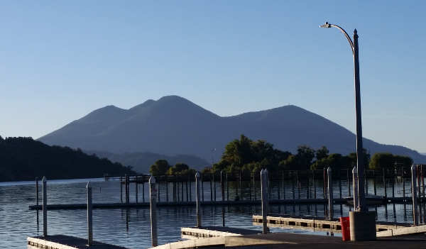
Sitting on the western shore of Clear Lake, the Clear Lake Volcanic Field’s most notable feature is Mount Konocti. It was ranked at No. 33, in the “high” threat category.
Elsewhere in California, the assessment lists Mt. Shasta and Lassen Volcanic Center in the “very high” ranking, placing them No. 5 and No. 11, respectively. The Long Valley Caldera in the Inyo National Forest near Yosemite National Park is in the very high threat category, at No. 18. The Mono-Inyo Craters, also near Yosemite, was listed in the “high” category at No. 24.
This 2018 update considers field and laboratory research that adds or removes volcanoes from the list of potentially active volcanoes, and updates the hazard and exposure factors used to produce a relative threat ranking of volcanoes.
Officials said the new document also adds or raises the threat level for 12 volcanoes and reduces or removes threat level status from 20 volcanoes.
The USGS said that, since 1980, there have been 120 eruptions and 52 episodes of notable volcanic unrest at 44 U.S. volcanoes.
John Ewert, a USGS volcanologist and lead author of the new assessment report based at the Cascades Volcanic Observatory in Vancouver, said the threat rankings are not an indication of which US volcano will erupt next but rather an indicator of the severity of impacts.
“The U.S. has quite a few geologically active volcanoes,” Ewert said.
Ewert said the 161 volcanoes in the study – eight less than the 2005 report, a net change due to the result of additions, naming changes and new research – make up about 10 percent of the earth’s active volcanoes, and have a large footprint over the United States extending from the Arctic to the tropics. Fourteen states and territories have volcanoes considered by this assessment.
“The US has nearly every type of volcano,” which are found in wildly different settings, said Ewert. What is known about their history varies greatly.
The survey systematically assesses U.S. volcanoes considered to be active or potentially active, and ranks the volcanoes based on 24 hazard and exposure factors. “To be included in the assessment, a volcano had to meet certain criteria,” said Ewert.
One of the key criteria is that a volcano has been active in geologically “recent time,” which Ewert explained is the Holocene, the current geological epoch which began nearly 12,000 years ago.
Once they assess the 24 factors for each volcano, they then group them into five categories. When ranking volcanoes, Ewert said that they combine the exposure and hazard scores, which highlight volcanoes that might otherwise have gotten lower.
He said 18 volcanoes in the United States are ranked as very high threat, and that group remains unchanged since the 2005 assessment.
There are 39 volcanoes in the high threat category, with Salton Buttes in California and Fourpeaked Mountain in Alaska added to the list; 49 volcanoes ranked as moderate, with new additions of Soda Lakes in Nevada and East Diamante in the commonwealth of the Northern Mariana Islands; 34 ranked as low threat; and 21 ranked as “very low threat,” the category that underwent the greatest changes due to new information, Ewert said.
This latest report also includes ash cloud risks, which was in the 2005 report. Ewert said the 2010 eruption in Iceland of the volcano Eyjafjallajökull, which went on for a six-month period and caused a six-day disruption in European air travel reported to be the most significant since World War II due to its enormous smoke output, is a good example of why it’s important to prioritize ash risk.
Ewert added that, when looking at the ash risk factor, you realize there are no geographically distant volcanoes.
The USGS said it uses the volcanic threat assessment to help guide and prioritize risk mitigation efforts at U.S. volcanoes through volcano research, hazard assessment, emergency planning and preparation and monitoring efforts with federal, state and local government partners.
Tom Murray is director of the USGS Volcano Science Center and line manager for the five volcano observatories in the United States – Alaska, California, Cascades, Hawaii and Yellowstone.
“It’s an important document for us,” he said of the report, which the USGS uses to guide and prioritize risk mitigation efforts, a cornerstone in the development of the National Volcano Early Warning System.
Research over the past decade has increased scientists’ understanding of volcanoes and also led to changes in the report, said Murray.
He acknowledged that there are monitoring deficiencies for most of the volcanoes, and that monitoring could be improved commensurate with their threat. “That’s the goal we’re trying to achieve.”
USGS officials also reported that many volcanoes are located in wilderness or national park areas, so they’re required to complete permits to establish monitoring sites, a process which can be slow. An example: The agency has been working for four years to get four monitoring sites placed around Glacier Peak in Washington.
As for other notable volcanoes, Margaret Mangan, scientist-in-charge at the California Volcano Observatory, said they closely monitor Mount Shasta, the hazard zone for which includes 9,500 square miles. She said 100,000 people live and work there on a regular basis, with large transient populations due to the presence of Interstate 5 and the National Forest.
There also is significant regional and state infrastructure in that area, including the Shasta Lake reservoir, which provides water to millions of people in the Bay Area and the Central Valley through the Bay Delta, Mangan said.
Mangan said there also is significant air traffic over Mount Shasta, with 800 jumbo jets flying over it on a daily basis.
“We have to think of the full gamut of life in volcanic areas,” Mangan said.
Mount Shasta is at No. 5, behind Kīlauea in Hawaii, Mount St. Helens and Mount Rainier in Washington, and Redoubt Volcano in Alaska.
USGS officials said Mount Rainier has 300,000 people in its downstream hazard zone.
Then there is the Yellowstone caldera in Wyoming, the location of the famed National Park.
“Yellowstone is an incredibly dynamic place. It’s always changing,” said Mike Poland, scientist-in-charge at the Yellowstone Volcano Observatory.
He said there is usually something going dormant or coming alive. “The ground is always moving up and down.”
The Yellowstone caldera experiences about 2,000 earthquakes a year. All of that activity, Poland added, is “what defines Yellowstone.”
In 2017 the USGS monitored the second largest seismic swarm in the Yellowstone caldera since monitoring began in 1970s. However, Poland added, “We don’t really have any indication that Yellowstone is doing anything abnormal.”
Ewert said scientists often get questions about the volcanoes in Alaska and Hawaii and whether eruptive events are connected to earthquakes and activity of other volcanoes. People like to make connections, he said, adding, “That’s what we do.”
However, unless volcanoes are right near each other, it’s difficult for them to share plumbing, Ewert said. “They tend to be independent operators.”
Understanding the Clear Lake Volcanic Field
Mangan said that the Clear Lake Volcanic Field is one of the centers that has a potential threat that only recently has been realized, which was why it was listed in the 2005 threat assessment as well as this newest document.
Mangan said field researchers work in the Clear Lake Volcanic Field, along with a special gas and water chemist, and field engineers who make sure the sensors already in the ground are maintained.
The field’s most prominent feature is the 300,000-year-old Mount Konocti, which Mangan said is believed to have last erupted about 11,000, right on the cusp of the Holocene era and on the borderline of what geologists would call “recent.”
“Mount Konocti is a series of several overlapping lava domes,” said Mangan. “It looks like one mountain but it’s actually made up of many eruptions in which very sticky, very viscous magma squeezed up through a vent and came out on the surface like globs of toothpaste.”
That magma mounded up around the vent to create a lava zone. “There have been several of those dome-forming eruptions,” Mangan said. “That is what created that mountain that is so majestic there on Clear Lake’s western shore.”
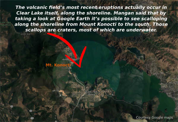
The volcanic field’s most recent eruptions about 11,000 years ago actually occurred in Clear Lake itself, along the shoreline. Mangan said that there were several of those “phreatic eruptions,” in which magma came up close to the surface of the earth and interacted with lake and groundwater, and produced steam explosions and rapid vaporization that created craters.
Mangan said that by taking a look at Google Earth it’s possible to see scalloping along the shoreline from Mount Konocti to the south. Those scallops are the craters, most of which are underwater, created by the phreatic eruptions.
In explaining the volcanic field, Mangan points out, “The Clear Lake Volcanic Field includes more than Mount Konocti.”
The other notables features that are of volcanic origin include areas where volcanic gases leaking out, which Mangan said is common.
Most of the magma that comes up to relatively shallow levels in the earth’s crust stays there. Mangan said it slowly cools and releases gas like what emerges at places like Sulphur Bank.
When a volcanologist talks of magma in the “near surface,” they mean 2 to 10 kilometers. For the Clear Lake Volcanic Field, Mangan said it’s around 6 kilometers.
There’s a pretty steady, low-level release of volcanic gases, most notably sulphur gases and carbon dioxide which originally was stored deep in the earth before being released from the magma and gradually making its way to the surface.
“It is a sign that the Clear Lake volcanic system isn’t done yet,” she said.
There also are areas on the lake like Soda Springs which people are warned to stay away from because of toxic gas emissions like carbon dioxide.
Mangan said carbon dioxide in water or snow can pond because it’s a dense gas. “You can build up some really big concentrations of C02, which is quite toxic to humans and other life forms.”
Since 2005, research and tracking of earthquakes, ground deformation and volcanic gas releases have shown that more research and monitoring are needed of the Clear Lake Volcanic Field, Mangan said. “It’s an important area of California.”
About two years ago, the California Volcanic Observatory started to shift some of its scientific research to the Clear Lake Volcanic Field, she said.
As a result, geophysical studies done in the past two years – in combination with work done in the 1970s and 1980s – shows that a zone of partially molten magma or rock exists under the field. As a result, they’re in the midst of additional research.
“We have a pretty robust research program going on in the Clear Lake area for the last two years,” she said. “We really need a better hazard zone map.”
They have a really good geologic map of the area which Mangan said can be used to create the volcano hazard zone map.
Mangan said they are working through the permitting process to add three more monitors in the Clear Lake Volcanic Field, which are expected to be in place in 2019 and 2020.
Before they can produce that hazard map and figure out where to put new monitoring equipment, they need to have a better understanding of what the current state of the volcanic system is, and where and how large are the zones of partially molten rock, Mangan said.
To do that, they’re using various types of geophysical measurements to provide a three-dimensional map of the subsurface of the Clear Lake Volcanic Field. One of the newest technologies for that purpose is magnetotellurics, which uses uses magnetism and electrical resistivity to map out zones where there are hot rock or partially molten rock below the surface.
The early results of the magnetotelluric survey are expected to come out sometime later this year, she said.
Another new technique they’re implementing is seismic tomography, which Mangan said uses seismometers to look at changes in seismic wave velocity.
When an earthquake happens and moves through the earth’s subsurface, those seismic waves will slow down in areas where there is partially molten or very hot rock. Mangan said that activity can be used to create surface images based on the seismic change velocity.
“We’re moving forward with the analysis of the current data that we’ve collected over the past two years, as well as adding new data to it. So it’s a work in progress,” she said, adding that it’s “one of the main ways to understand what’s underneath our feet up there.”
The USGS reported that its monitoring in the Clear Lake Volcanic Field and a collaborative effort with Calpine Corp. in The Geysers geothermal steam field provides real-time tracking of earthquake activity. In addition, the USGS periodically analyzes volcanic gases and hot springs in the region.
Mangan explained that The Geysers sits adjacent to the Clear Lake Volcanic Field on the western margin. “They are separate systems,” she said.
She added that what drives the geothermal system is hot rock and partially molten rock down deep in The Geysers region.
While people think about geothermal development and whether that production could impact a volcanic center, causing it to erupt, “It really is not the case,” said Mangan.
“The geothermal system is really shallow compared to the magmatic system,” she said, adding, “They’re just too far apart vertically.”
She said the Clear Lake Volcanic Field does have earthquakes, but they don’t happen often – only a few dozen a year – are usually below magnitude 2 and are deep, between 6 and 10 kilometers. That’s unlike the earthquakes in The Geysers, which are shallow and are the result of geothermal operations.
Increased monitoring planned
Mangan said volcano monitoring is essentially a three-legged stool, involving gathering data on earthquakes, ground deformation and gas emissions.
She said they have the seismicity and gas emissions covered pretty well, but don’t have ground deformation sensors in the field proper and want to increase overall monitoring. “We do need to increase our monitoring there.”
That’s why they plan to add three additional seismometers in 2019 or as late as 2020. It’s most important to have an adequate seismic network, which is the key type of sensor. “Right now it’s rather skeletal,” Mangan said of the monitoring system.
The California Volcanic Observatory has about 50 sensors, with four seismic sensors in the Clear Lake Volcanic Field, where Mangan said they want to fill in gaps, as it’s important to have a 360-degree arrangement in seismometers on a volcano.
Mangan said the new monitoring equipment already has been purchased. They just need to have their field engineers – who maintain the existing sensors – select the actual place on the ground to locate them.
Currently, monitoring equipment sends seismic data in real-time to the California Volcanic Observatory’s headquarters in Menlo Park. “That data is constantly streaming in,” Mangan said.
She said that if there’s anything unusual with respect to seismicity in the area, she’s attached to a beeper and she gets a notification.
At that point, she would interact with the observatory’s volcanologist to interpret that real-time monitoring.
Asked if that has happened for the Clear Lake Volcanic Field, Mangan said no, that so far nothing unusual has popped up.
Email Elizabeth Larson at
2018 Update to the U.S. Geological Survey National Volcanic Threat Assessment by LakeCoNews on Scribd