 How to resolve AdBlock issue?
News
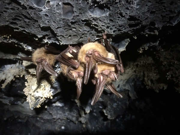
NORTHERN CALIFORNIA – Conservation of bats has long been hindered by a lack of knowing their winter whereabouts, particularly in the western United States.
With the confirmed case of white-nose syndrome in western Washington in 2016, a new impetus has been placed on finding these secluded roosts scattered across millions of acres to more closely track the disease and its effects.
National wildlife databases contained sparse and sporadic data on winter roosts of western bats. However, a concerted effort by the scientific community has produced one of the largest, most complete dataset of recorded hibernacula in the western United States.
“We knew from the research of others that the data had to exist,” said Ted Weller, a wildlife biologist and bat specialist with the U.S. Forest Service’s Pacific Southwest Research Station, who was one of the leaders on the project. “We just needed to get it all in the same place.”
Weller and his colleagues canvassed federal and state agencies, as well as the academic community, across 11 western states to amass 4,549 winter bat survey records.
Their findings, detailed in “A Review of Bat Hibernacula Across the Western United States: Implications for White-Nose Syndrome Surveillance and Management,” were recently released online in PLoS One.
White-nose syndrome is a highly lethal fungus presumed to be spread among bats during their winter hibernations, where their wet, cool hibernacula are conducive to the syndrome’s pathology.
Originally detected on the East Coast in 2006, the occurrence of white-nose syndrome in Washington state leap-frogged the disease’s western-most exposure by more than 800 miles, wildly outpacing its predicted rate of spread. And in the process, encapsulating the western bat population from both its eastern and western fronts.
The two most prevalent types of bats recorded in the surveys were bats within the genus Myotis and the Townsend’s big-eared bat (Corynorhinus townsendii).
In the 82 structures that were surveyed five or more times since 1990, researchers reported that bat populations were found to be stable.
One somewhat encouraging finding was the relative seclusion in which bats roosted in the West. About 95 percent of Myotis encounters were of individuals or groups of 10 or fewer bats; 72 percent of Townsend’s big-eared bat encounters were similarly small.
“While such small roosting aggregations lead us to believe that there are a lot more hibernacula out there,” Weller said, “the relative isolation of these species’ roosting behavior could help mitigate the exposure or spread of white-nose syndrome.”
Of the survey records, only four documented Myotis aggregations of 500 or more bats, each located in a separate state (Arizona, Idaho, Montana and New Mexico). Only six records documented Townsend’s big-eared bat aggregations in excess of 100 bats, five of those records occurring in Nevada mines.
Weller said he and his colleagues hope others will be able to build upon their work of pooling the surveys of others to produce a collective monitoring database. Toward that end, the researchers have made their research available as a public dataset. The dataset removes structure names and only provides a general location description to prevent disclosure of exact hibernacula locations.
“We acknowledge the legal and proprietary concerns surrounding data sharing,” Weller said. “But the conservation community can no longer afford to lose occurrence records, especially when a unified effort could go a long way in monitoring hibernating bats in the face of disease or other emerging threats.”
Headquartered in Albany, California, the Pacific Southwest Research Station is part of the U.S. Forest Service’s Research and Development branch developing and communicating science needed to sustain forest ecosystems and other benefits to nature and society. Pacific Southwest Research Station scientists are engaged in research across a network of 14 experimental watersheds, ranges and forests and eight research facilities in California, Hawaii and the U.S.-affiliated Pacific Islands.
LAKE COUNTY, Calif. – With daylight saving time ending on Sunday, Nov. 4, the time change may disrupt sleep patterns and affect the ability to concentrate and safely operate a motor vehicle.
To highlight the dangers of fatigued driving, the California Highway Patrol joins the Office of Traffic Safety, the California Department of Transportation and the National Sleep Foundation in recognizing Drowsy Driving Prevention Week, Nov. 5 to 12.
“Safely operating a motor vehicle while on California’s roadways should be the goal of every driver, and that includes staying alert and not allowing yourself to drive while drowsy,” said CHP Commissioner Warren Stanley. “Drowsy driving can be as much of an impairment as drugs or alcohol.”
The Centers for Disease Control and Prevention states going without sleep for at least 18 hours is the same as having a blood alcohol content of .05 percent.
“We all have places to go, but if you are too tired to drive, you should not be driving,” OTS Director Rhonda Craft said. “Like impaired or distracted driving, drowsy driving puts yourself and others at risk.”
Caltrans will use the electronic Changeable Message Signs along highways to raise awareness of the dangers of drowsy driving. Almost 900 signs across the state will display the message “Feel Drowsy? Exit and Rest.”
“In today’s 24/7 society, we need a good reminder that if you are driving fatigued or sleepy you need to exit and rest rather than putting your life and others in jeopardy,” said Caltrans Director Laurie Berman. “Caltrans maintains more than 80 safety roadside rest areas across the state.”
To find a rest area in your area, or to check for the latest travel information on state highways, visit http://quickmap.dot.ca.gov/.
Some suggested tips to avoid drowsy driving include: getting enough sleep (at least seven hours a day), sticking to a sleep schedule, and avoid alcohol or medications that can cause drowsiness.
Caffeinated beverages may help in the short term, but are not a substitute for sleep or rest. Make it your goal to minimize the risks of driving drowsy for you, your passengers and other motorists.
Engineers and scientists gathered around a screen in an operations room at the Naval Research Laboratory in Washington, D.C., eager to lay their eyes on the first data from NASA’s STEREO spacecraft.
It was January 2007, and the twin STEREO satellites – short for Solar and Terrestrial Relations Observatory – which had launched just months before, were opening their instruments’ eyes for the first time.
First up: STEREO-B. The screen blinked, but instead of the vast starfield they expected, a pearly white, feathery smear – like an angel’s wing – filled the frame.
For a few panicky minutes, NRL astrophysicist Karl Battams worried something was wrong with the telescope. Then, he realized this bright object wasn’t a defect, but an apparition, and these were the first satellite images of Comet McNaught. Later that day, STEREO-A would return similar observations.
Comet C/2006 P1 – also known as Comet McNaught, named for astronomer Robert McNaught, who discovered it in August 2006 – was one of the brightest comets visible from Earth in the past 50 years.
Throughout January 2007, the comet fanned across the Southern Hemisphere’s sky, so bright it was visible to the naked eye even during the day. McNaught belongs to a rarefied group of comets, dubbed the Great Comets and known for their exceptional brightness.
Setting McNaught apart further still from its peers, however, was its highly structured tail, composed of many distinct dust bands called striae, or striations, that stretched more than 100 million miles behind the comet, longer than the distance between Earth and the Sun.
One month later, in February 2007, an ESA (European Space Agency) and NASA spacecraft called Ulysses would encounter the comet’s long tail.
“McNaught was a huge deal when it came because it was so ridiculously bright and beautiful in the sky,” Battams said. “It had these striae – dusty fingers that extended across a huge expanse of the sky. Structurally, it’s one of the most beautiful comets we’ve seen for decades.”
How exactly the tail broke up in this manner, scientists didn’t know. It called to mind reports of another storied comet from long ago: the Great Comet of 1744, which was said to have dramatically fanned out in six tails over the horizon, a phenomenon astronomers then couldn’t explain.
By untangling the mystery of McNaught’s tail, scientists hoped to learn something new about the nature of comets – and solve two cosmic mysteries in one.
A key difference between studying comets in 1744 and 2007 is, of course, our ability to do so from space. In addition to STEREO’s serendipitous sighting, another mission, ESA/NASA’s SOHO – the Solar and Heliospheric Observatory – made regular observations as McNaught flew by the Sun. Researchers hoped these images might contain their answers.
Now, years later, Oliver Price, a planetary science Ph.D. student at University College London’s Mullard Space Science Laboratory in the United Kingdom, has developed a new image-processing technique to mine through the wealth of data.
Price’s findings – summarized in a recently published Icarus paper – offer the first observations of striations forming, and an unexpected revelation about the Sun’s effect on comet dust.
Comets are cosmic crumbs of frozen gas, rock and dust left over from the formation of our solar system 4.6 billion years ago – and so they may contain important clues about our solar system’s early history.
Those clues are unlocked, as if from a time capsule, every time a comet’s elliptical orbit brings it close to the Sun. Intense heat vaporizes the frozen gases and releases the dust within, which streams behind the comet, forming two distinct tails: an ion tail carried by the solar wind – the constant flow of charged particles from the Sun – and a dust tail.
Understanding how dust behaves in the tail – how it fragments and clumps together – can teach scientists a great deal about similar processes that formed dust into asteroids, moons and even planets all those billions of years ago.
Appearing as one of the biggest and most structurally complex comets in recent history, McNaught was a particularly good subject for this type of study. Its brightness and high dust production made it much easier to resolve the evolution of fine structures in its dust tail.
Price began his study focusing on something the scientists couldn’t explain. “My supervisor and I noticed weird goings-on in the images of these striations, a disruption in the otherwise clean lines,” he said. “I set out to investigate what might have happened to create this weird effect.”
The rift seemed to be located at the heliospheric current sheet, a boundary where the magnetic orientation, or polarity, of the electrified solar wind changes directions. This puzzled scientists because while they have long known a comet’s ion tail is affected by the solar wind, they had never seen the solar wind impact dust tails before.
Dust in McNaught’s tail – roughly the size of cigarette smoke – is too heavy, the scientists thought, for the solar wind to push around. On the other hand, an ion tail’s miniscule, electrically charged ions and electrons easily sail along the solar wind.
But it was difficult to tell exactly what was going on with McNaught’s dust, and where, because at roughly 60 miles per second, the comet was rapidly traveling in and out of STEREO and SOHO’s view.
“We got really good data sets with this comet, but they were from different cameras on different spacecraft, which are all in different places,” Price said. “I was looking for a way to bring it all together to get a complete picture of what’s happening in the tail.”
His solution was a novel image-processing technique that compiles all the data from different spacecraft using a simulation of the tail, where the location of each tiny speck of dust is mapped by solar conditions and physical characteristics like its size and age, or how long it’d been since it’d flown off the head, or coma, of the comet.
The end result is what Price dubbed a temporal map, which layers information from all the images taken at any given moment, allowing him to follow the dust’s movements.
The temporal maps meant Price could watch the striations form over time. His videos, which cover the span of two weeks, are the first to track the formation and evolution of these structures, showing how dust fragments topple off the comet head and collapse into long striations.
But the researchers were most excited to find that Price’s maps made it easier to explain the strange effect that drew their attention to the data in the first place. Indeed, the current sheet was the culprit behind the disruptions in the dust tail, breaking up each striation’s smooth, distinct lines.
For the two days it took the full length of the comet to traverse the current sheet, whenever dust encountered the changing magnetic conditions there, it was jolted out of position, as if crossing some cosmic speed bump.
“It’s like the striation’s feathers are ruffled when it crosses the current sheet,” University College London planetary scientist Geraint Jones said. “If you picture a wing with lots of feathers, as the wing crosses the sheet, lighter ends of the feathers get bent out of shape. For us, this is strong evidence that the dust is electrically charged, and that the solar wind is affecting the motion of that dust.”
Scientists have long known the solar wind affects charged dust; missions like Galileo, Cassini and Ulysses watched it move electrically charged dust through the space near Jupiter and Saturn.
But it was a surprise for them to see the solar wind affect larger dust grains like those in McNaught’s tail – about 100 times bigger than the dust seen ejected from around Jupiter and Saturn – because they’re that much heavier for the solar wind to push around.
With this study, scientists gain new insights into long-held mysteries. The work sheds light on the nature of striated comet tails from the past and provides a crucial lens for studying other comets in the future. But it also opens a new line of questioning: What role did the Sun have in our solar system’s formation and early history?
“Now that we see the solar wind changed the position of dust grains in McNaught’s tail, we can ask: Could it have been the case that early on in the solar system’s history, the solar wind played a role in organizing ancient dust as well?” Jones said.
Lina Tran works for NASA’s Goddard Space Flight Center in Greenbelt, Md.
KELSEYVILLE, Calif. – State officials are conducting an investigation into a school construction accident that resulted in a worker’s death last week.
The incident occurred on Tuesday, Oct. 23, at Kelseyville High School, according to Kelseyville Unified Superintendent Dave McQueen.
On that day, an employee of the construction company FRC Inc. was injured while working on the high school’s new shop building. McQueen said the construction worker died of his injuries the following day, on the morning of Wednesday, Oct. 24.
Kelseyville Fire Chief Joe Huggins said fire personnel responded to the scene and the injured man was flown out of county. He did not have additional details on the incident.
Lt. Corey Paulich of the Lake County Sheriff’s Office said that agency didn’t handle the coroner’s case, as he believed the man had been flown to Santa Rosa.
Frank Polizzi, spokesman for the Department of Industrial Relations in the Division of Occupational Safety and Health, or Cal/OSHA, said the agency is investigating the incident.
“Cal/OSHA was notified of a fatality in Kelseyville on November 1. The report to Cal/OSHA indicated that an apprentice carpenter for FRC Inc. suffered a fall from a scissor lift on October 23 and died on November 1,” Polizzi said.
“Cal/OSHA has opened an inspection to identify the cause of the incident and may issue citations for violations of workplace safety regulations,” he added.
Polizzi said Cal/OSHA has up to six months to issue citations in the case.
So far, it is not clear why the date of the worker’s death was reported to the state as being a week later than the date confirmed by Kelseyville Unified.
Cal/OSHA also did not release the man’s name – Polizzi said the man’s name would appear in Cal/OSHA’s records once the inspection is complete – and calls to the the Windsor-based FRC Inc. were not returned.
However, Jendi Coursey, who has assisted Kelseyville Unified on community outreach on its Measure U bond projects – which include the $3.5 million high school shop building – said she has been helping FRC Inc., and directed Lake County News to a Go Fund Me site for the young man who died.
That Go Fund Me page, started by the man’s family, identified him as Juan Pablo Cuevas Jimenez, a veteran of the United States Marines who leaves behind a wife.
“FRC is in the process of completing all the necessary reviews, while also trying to support the family of the deceased. It’s a heartbreaking situation all the way around,” Coursey said.
As of Friday night, the Go Fund Me page, which was started on Oct. 24 and has a goal of $9,000 to cover the expenses for Cuevas Jimenez’s Nov. 9 funeral in Santa Rosa, had raised $4,875.
McQueen said all students and employees from Kelseyville Unified are safe as they have fencing that keeps personnel and students safely away from bond construction sites.
“This was a real tragedy and our thoughts and prayers are with the family of the deceased,” McQueen said.
Email Elizabeth Larson atThis email address is being protected from spambots. You need JavaScript enabled to view it. . Follow her on Twitter, @ERLarson, or Lake County News, @LakeCoNews.
The incident occurred on Tuesday, Oct. 23, at Kelseyville High School, according to Kelseyville Unified Superintendent Dave McQueen.
On that day, an employee of the construction company FRC Inc. was injured while working on the high school’s new shop building. McQueen said the construction worker died of his injuries the following day, on the morning of Wednesday, Oct. 24.
Kelseyville Fire Chief Joe Huggins said fire personnel responded to the scene and the injured man was flown out of county. He did not have additional details on the incident.
Lt. Corey Paulich of the Lake County Sheriff’s Office said that agency didn’t handle the coroner’s case, as he believed the man had been flown to Santa Rosa.
Frank Polizzi, spokesman for the Department of Industrial Relations in the Division of Occupational Safety and Health, or Cal/OSHA, said the agency is investigating the incident.
“Cal/OSHA was notified of a fatality in Kelseyville on November 1. The report to Cal/OSHA indicated that an apprentice carpenter for FRC Inc. suffered a fall from a scissor lift on October 23 and died on November 1,” Polizzi said.
“Cal/OSHA has opened an inspection to identify the cause of the incident and may issue citations for violations of workplace safety regulations,” he added.
Polizzi said Cal/OSHA has up to six months to issue citations in the case.
So far, it is not clear why the date of the worker’s death was reported to the state as being a week later than the date confirmed by Kelseyville Unified.
Cal/OSHA also did not release the man’s name – Polizzi said the man’s name would appear in Cal/OSHA’s records once the inspection is complete – and calls to the the Windsor-based FRC Inc. were not returned.
However, Jendi Coursey, who has assisted Kelseyville Unified on community outreach on its Measure U bond projects – which include the $3.5 million high school shop building – said she has been helping FRC Inc., and directed Lake County News to a Go Fund Me site for the young man who died.
That Go Fund Me page, started by the man’s family, identified him as Juan Pablo Cuevas Jimenez, a veteran of the United States Marines who leaves behind a wife.
“FRC is in the process of completing all the necessary reviews, while also trying to support the family of the deceased. It’s a heartbreaking situation all the way around,” Coursey said.
As of Friday night, the Go Fund Me page, which was started on Oct. 24 and has a goal of $9,000 to cover the expenses for Cuevas Jimenez’s Nov. 9 funeral in Santa Rosa, had raised $4,875.
McQueen said all students and employees from Kelseyville Unified are safe as they have fencing that keeps personnel and students safely away from bond construction sites.
“This was a real tragedy and our thoughts and prayers are with the family of the deceased,” McQueen said.
Email Elizabeth Larson at
LAKE COUNTY, Calif. – The National Weather Service has issued another red flag warning for Lake and its neighboring counties due to a forecast of high winds.
The red flag warning for Lake, Colusa, Napa, Solano, Sonoma and Yolo counties is in effect from 12 a.m. Saturday through 6 a.m. Sunday.
A red flag warning means a combination of factors – high winds and low humidity, plus very dry vegetation – are resulting in critical fire weather conditions.
The regional forecast calls for northeast winds from 15 to 30 miles per hour, with gusts of 40 to 50 miles per hour locally, and up to 50 to 60 miles per hour in the highest peaks.
The specific Lake County forecast indicates that the south county will see the highest wind speeds, ranging into the mid 20s.
In response to the red flag event, the Cal Fire Sonoma-Lake-Napa Unit has once again bolstered its firefighting resources.
Cal Fire said it is staffing all fire crews and bulldozers 24 hours a day and has additional personnel ready to fill command and control functions in the event of a major fire.
Cal Fire Unit Chief Shana Jones wants to remind residents creating defensible space is essential to improve your home’s chance of surviving a wildfire. To learn about what you can do to be ready visit http://www.readyforwildfire.org/Defensible-Space/.
Email Elizabeth Larson atThis email address is being protected from spambots. You need JavaScript enabled to view it. . Follow her on Twitter, @ERLarson, or Lake County News, @LakeCoNews.
The red flag warning for Lake, Colusa, Napa, Solano, Sonoma and Yolo counties is in effect from 12 a.m. Saturday through 6 a.m. Sunday.
A red flag warning means a combination of factors – high winds and low humidity, plus very dry vegetation – are resulting in critical fire weather conditions.
The regional forecast calls for northeast winds from 15 to 30 miles per hour, with gusts of 40 to 50 miles per hour locally, and up to 50 to 60 miles per hour in the highest peaks.
The specific Lake County forecast indicates that the south county will see the highest wind speeds, ranging into the mid 20s.
In response to the red flag event, the Cal Fire Sonoma-Lake-Napa Unit has once again bolstered its firefighting resources.
Cal Fire said it is staffing all fire crews and bulldozers 24 hours a day and has additional personnel ready to fill command and control functions in the event of a major fire.
Cal Fire Unit Chief Shana Jones wants to remind residents creating defensible space is essential to improve your home’s chance of surviving a wildfire. To learn about what you can do to be ready visit http://www.readyforwildfire.org/Defensible-Space/.
Email Elizabeth Larson at
LAKE COUNTY, Calif. – A harmful pesticide that’s on a federal restricted list has been located in Lake County, according to Lake County health officials.
On Sept. 21, during searches conducted by the California Department of Fish and Wildlife and the Lake County Sheriff’s Office of cannabis grow sites on private property, samples of an unknown substance were obtained that were confirmed on Wednesday as US EPA severely restricted pesticides, according to the Lake County Health Services Department.
There are two sites with confirmed presence of the pesticide at very high concentrations, and three sites with specimens sent to the laboratory with results currently pending.
The known sites are in the Lower Lake area – one is on Rocky Creek Road off of Morgan Valley; the other is on Spruce Grove Road south of Lower Lake. Warning signs to avoid the areas will be posted at the entrances to the affected properties.
The pesticide confirmed is Carbofuran, which is an organophospahate, a harmful pesticide to the public and the environment.
A bird on one site was confirmed dead due to organophosphate poisoning. These chemicals can cause reproductive harm, acute poisoning, and have possible long-term effects.
Seek medical treatment if you believe you have been in contact with these chemicals or are experiencing the following symptoms: blurred vision, pinpoint pupils, tearing, excessive respiratory secretions; salivation; sweating; abdominal cramps, headache, nausea, vomiting, diarrhea; lightheadedness; chest tightness, epigastric pain, labored breathing; cyanosis; muscle twitching; incoordination; convulsions; unconsciousness; respiratory failure; skin irritation.
The Lake County Health Services Department We will continue to notify the public until the spill has been remediated.
If you have a shallow well in the area, consider filtering your water with a granular activated carbon filter and non-ionic polymeric resin filters. Individuals can Google NSF 42, 53, and 401 point-of-use or point –of-entry filters.
For more information, contact the Lake County Health Services Department at 707-263-1090. After hours, please dial 9 to be connected.