 How to resolve AdBlock issue?
News

LAKE COUNTY, Calif. – Finally! As I write this, our favorite star, the sun is shining brightly in our beautiful, blue Lake County skies once again.
After living in a sepia-colored, smoky world for so long I began paying attention to the diversity of yellow flora and fauna in the surrounding landscape now.
Those who study color psychology tell us that the color yellow solicits our attention more than almost any other color.
Yellow is said to be the shade of cheerfulness and contentment; of hopefulness, creativity along with inspiration. The happy-face color is also the color of vibrant lemons and cheerful daffodils.
Yellow tarweed makes itself known before it is even seen, through its piquant scent that clings to clothes if you happen to brush against it as you wander by. If you touch it you'll have sticky fingers for some time to come.
According to Calscape, the California Native Plant Society guide there are 51 kinds of tarweed native to California, and most are yellow or white in color.
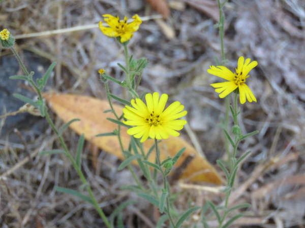
These summer-to-fall blooming flowers have earned their name due to the secretions that coat their leaves and stems.
The special coating plays several important roles. One is that it aids the plants in retaining moisture during the heat of the day, thereby rendering them drought-tolerant, and another is that tarweed's coating keeps them from being eaten by insects or animals.
There are studies that show that some tarweed species attract insects by causing them to adhere to the plants' sticky coating then in turn, allow yet another kind of insect to dine on the tarweed victims who are stuck. This clever ability causes a decline in insects that are undesirable to the tarweed.
Some varieties of the plant were used by native peoples when they harvested the seeds to make pinole.
The book, “California Indians and their Environment” by Kent G. Lightfoot and Otis Parrish, explains that seeds from some tarweed varieties were stored raw, for use during the year when they could be cooked and pounded prior to consumption.
Is there any flower more cheering than the pollinator-friendly sunflower? These butter yellow beauties attract a large variety of both native bees and honey bees along with other pollinators such as moths and butterflies, all while producing delicious and nutritious seeds for human and avian consumption.
The Great Sunflower Project is a great way to investigate this humble plant as well as to contribute to citizen science. The organization has more than 100,000 members and has a handy set of bee identification cards for those who are interested and curious.
Native sunflowers, which grow in spring, and are smaller in stature, are also terrific pollinator-friendly plants and were used as a food source for native peoples.
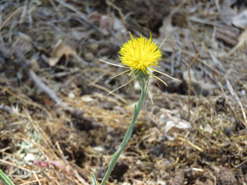
A familiar but invasive yellow plant is the starthistle, a noxious weed that probably arrived in California during the Gold Rush era by fastening itself to alfalfa seed. This spiky plant originated in Turkey or Greece.
The release of a particular type of weevil – along with control burns and herbicides in some areas – has somewhat reduced the onslaught of starthistle plants. Its mellow yellow color, along with the fact that it attracts honey bees, is not reason enough to like this plant, since it takes over and crowds out native plant populations and is poisonous to horses.
I've never met a bird I didn't like, and the lesser goldfinches that congregate at my feeder always put a smile on my face. They are found in open woodlands in the oaks, cottonwoods and willow trees where they consume a variety of seed types.
These diminutive yellow and black songbirds use their sturdy bills to pry open seeds but sometimes complement their diet with plant lice.
The primary color of yellow may influence your mood and your thinking – it may even determine your snack choice by persuading you to dine on some delectable golden, locally grown pears and apples.
Kathleen Scavone, M.A., is a retired educator, potter, freelance writer and author of “Anderson Marsh State Historic Park: A Walking History, Prehistory, Flora, and Fauna Tour of a California State Park” and “Native Americans of Lake County.”

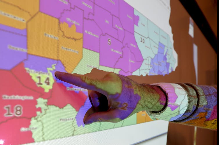
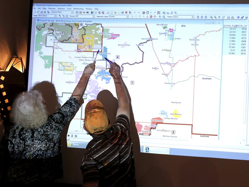
When voters cast their ballots in November, they won’t just decide who will be president in 2021 – they will also have a voice in determining the partisan makeup of Congress until 2030. Following each census, which happens every 10 years, states are required to adjust their congressional district boundaries to keep district populations equal.
District boundaries can profoundly shape election results – most notably when they are drawn in ways that benefit one political party or the other.
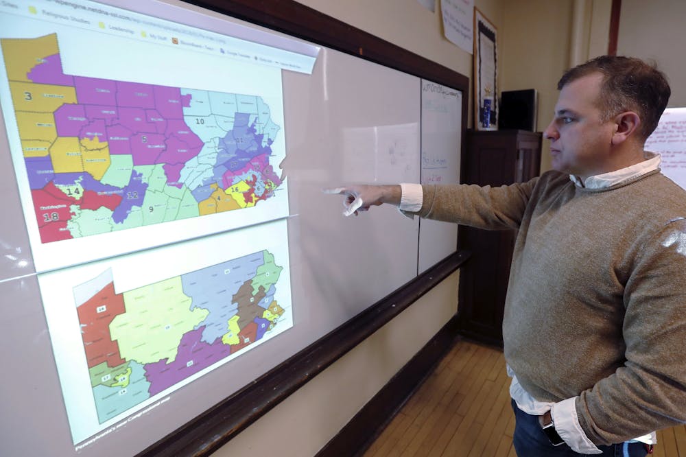
In the 2011 redistricting after the 2010 census, for example, Pennsylvania’s Republican-led legislature drew up districts that significantly disadvantaged Democrats. In the state’s 2012 congressional elections, Democrats won a majority of the votes, but Republicans won two-thirds of the state’s 18 seats in Congress. Our research has found that similarly biased redistricting – called partisan gerrymandering – is common across the country.
Most states give the power to draw new boundaries to their legislatures. So when voters in November pick among the candidates for state legislatures, they are choosing the people who will make the new electoral maps. That means the 2020 election will potentially affect the balance of power and the degree of partisan conflict in the House of Representatives for the next decade.
Legislators often draw biased lines
In drawing new boundaries, state legislators usually have very few constraints. The U.S. Constitution requires that each congressional district should represent a roughly equal number of people – except in states with too few people to have multiple districts – Alaska, Delaware, Montana, North Dakota, South Dakota, Vermont and Wyoming. They all get at least one representative in Congress.
But other than that, state lawmakers make their own rules. So it’s not surprising that congressional district lines tend to unfairly advantage the party whose members are a majority of the group drawing the lines.
In the seven small, single-district states and the District of Columbia, this isn’t a problem because the state boundaries are also those of the congressional district. In five others – Hawaii, Idaho, Maine, New Hampshire and Rhode Island – there are only enough people to warrant two congressional districts, making it statistically impossible to manipulate district boundaries to advantage one party.
But of the remaining 38 states, our analysis found that 22 created gerrymandered districts that benefited one party or the other. Other political scientists have come to similar conclusions after their own analyses. This is true despite the natural, nongerrymandered tendency for like-minded people, especially Democrats, to live near each other.
Most of the partisan gerrymandering created after the 2010 census benefited the Republican Party. That is because Republicans won control of many state legislatures in the 2010 elections, and then delivered congressional districts in their favor.
The bias from partisan gerrymandering was so high after the 2010 round of redistricting, particularly in seven states – Michigan, North Carolina, Pennsylvania, Ohio, Wisconsin, Virginia and Florida – that the 2012 elections produced a House of Representatives controlled by the Republican Party even though Democratic congressional candidates won more votes nationwide.
The 2020 state legislative elections will be similarly decisive of who will control the redistricting process, and what congressional elections will look like for the next decade.
Reforming the process
There are efforts to fix the redistricting process. In 2019, the Supreme Court effectively barred federal courts from considering whether partisan gerrymanders are constitutional, so reformers must look elsewhere for a solution.
Reform movements are working to take control of district boundaries out of the hands of legislators.
Several states have pioneered ways to draw their congressional boundaries more fairly. In New York, for instance, there is a commission that will advise lawmakers on potential maps that avoid partisan advantages. In Arizona and California, independent commissions have complete control over the district boundaries.
In New Jersey and Hawaii, commissions made up of politicians and political appointees draw the boundaries. And in three states – Connecticut, Indiana and Ohio – the legislature gets a first attempt to draw the boundaries, but must relinquish power to an independent commission if lawmakers can’t agree.
In some states, citizens have created independent redistricting commissions by popular referendum – through ballot propositions or initiatives – when legislators didn’t want to strip themselves of this key power. Colorado, Michigan and Utah all did this in 2018. Voters in Virginia will be given an option in the 2020 election to hand redistricting authority over to an independent commission.
Our research and others’ has found that commissions of all types tend to produce maps that are less biased than legislative ones. However, redistricting reforms in some states are now facing a backlash from state lawmakers who are attempting to reclaim power over the redistricting process through legislation, lawsuits or ballot measures of their own.
[Deep knowledge, daily. Sign up for The Conversation’s newsletter.]
In presidential election years, the public is obviously focused on the race for the White House, but the decisions voters make in state legislative races affect the partisan composition of Congress for years to come. Without changes in who draws district lines, the U.S. is likely to enter another decade in which congressional elections are shaped not by everyday voters but by those who hold the power.![]()
Robin Best, Associate Professor of Political Science, Binghamton University, State University of New York and Steve Lem, Professor of Political Science and Public Administration, Kutztown University of Pennsylvania
This article is republished from The Conversation under a Creative Commons license. Read the original article.
Dogs available for adoption this week include mixes of Belgian Malinois, border collie, Chihuahua, German Shepherd, husky, Labrador Retriever, pit bull, Rhodesian Ridgeback and Shar Pei.
Dogs that are adopted from Lake County Animal Care and Control are either neutered or spayed, microchipped and, if old enough, given a rabies shot and county license before being released to their new owner. License fees do not apply to residents of the cities of Lakeport or Clearlake.
The following dogs at the Lake County Animal Care and Control shelter have been cleared for adoption (additional dogs on the animal control Web site not listed are still “on hold”).
Call Lake County Animal Care and Control at 707-263-0278 or visit the shelter online at http://www.co.lake.ca.us/Government/Directory/Animal_Care_And_Control.htm for information on visiting or adopting.

Male Chihuahua
This male Chihuahua has a short black and tan coat.
He is in kennel No. 6a, ID No. 14038.

‘Mamacita’
“Mamacita” is a senior female Chihuahua with a short tan coat.
She is in kennel No. 6b, ID No. 14040.

Female Labrador Retriever
This female Labrador Retriever mix has a short black coat with white markings.
She is in kennel No. 9, ID No. 13989.

Male pit bull
This male pit bull has a short white and brindle coat.
He is in kennel No. 20, ID No. 14058.

Rhodesian Ridgeback-Shar Pei mix
This male Rhodesian Ridgeback-Shar Pei mix has a short tan coat.
He is in kennel No. 25, ID No. 14023.

Belgian Malinois mix
This female Belgian Malinois mix has a short brindle coat.
She is in kennel No. 26, ID No. 14024.

Male border collie
This young male border collie has a short black and white coat.
He is in kennel No. 27, ID No. 14052.

‘Lilly’
“Lilly” is a female pit bull-husky mix with a short brown and white coat.
She is in kennel No. 29, ID No. 13991.
Email Elizabeth Larson at
A historic moment is on the horizon for NASA’s OSIRIS-REx mission.
In just a few weeks, the robotic OSIRIS-REx spacecraft will descend to asteroid Bennu’s boulder-strewn surface, touch down for a few seconds and collect a sample of the asteroid’s rocks and dust – marking the first time NASA has grabbed pieces of an asteroid, which will be returned to Earth for study.
On Oct. 20, the mission will perform the first attempt of its Touch-And-Go, or TAG, sample collection event.
This series of maneuvers will bring the spacecraft down to site Nightingale, a rocky area 52 feet in diameter in Bennu’s northern hemisphere, where the spacecraft’s robotic sampling arm will attempt to collect a sample.
Site Nightingale was selected as the mission’s primary sample site because it holds the greatest amount of unobstructed fine-grained material, but the region is surrounded by building-sized boulders.
During the sampling event, the spacecraft, which is the size of a large van, will attempt to touch down in an area that is only the size of a few parking spaces, and just a few steps away from some of these large boulders.
During the 4.5-hour sample collection event, the spacecraft will perform three separate maneuvers to reach the asteroid’s surface.
The descent sequence begins with OSIRIS-REx firing its thrusters for an orbit departure maneuver to leave its safe-home orbit approximately 2,500 feet from Bennu's surface.
After traveling four hours on this downward trajectory, the spacecraft performs the “Checkpoint” maneuver at an approximate altitude of 410 feet. This thruster burn adjusts OSIRIS-REx’s position and speed to descend steeply toward the surface.
About 11 minutes later, the spacecraft performs the “Matchpoint” burn at an approximate altitude of 177 feet, slowing its descent and targeting a path to match the asteroid's rotation at the time of contact.
The spacecraft then descends to the surface, touches down for less than 16 seconds and fires one of its three pressurized nitrogen bottles. The gas agitates and lifts Bennu’s surface material, which is then caught in the spacecraft’s collector head.
After this brief touch, OSIRIS-REx fires its thrusters to back away from Bennu’s surface and navigates to a safe distance from the asteroid.
After the orbit departure maneuver, the spacecraft undertakes a sequence of reconfigurations to prepare for sampling. First, OSIRIS-REx extends its robotic sampling arm – the Touch-And-Go Sample Acquisition Mechanism, or TAGSAM – from its folded storage position out to the sample collection position.
The spacecraft’s two solar panels then move into a “Y-wing” configuration over the spacecraft’s body, which positions them safely up and away from the asteroid’s surface during touch down.
This configuration also places the spacecraft’s center of gravity directly over the TAGSAM collector head, which is the only part of the spacecraft that will contact Bennu’s surface during the sample collection event.
Because the spacecraft and Bennu are approximately 207 million miles from Earth during TAG, it will take about 18.5 minutes for signals to travel between them.
This time lag prevents the live commanding of flight activities from the ground during the TAG event, so the spacecraft is designed to perform the entire sample collection sequence autonomously.
Prior to the event’s start, the OSIRIS-REx team will uplink all of the commands to the spacecraft and then send a “GO” command to begin.
To autonomously navigate to site Nightingale, OSIRIS-REx uses the Natural Feature Tracking, or NFT, navigation system. The spacecraft begins collecting navigation images about 90 minutes after orbit departure. It then compares these real-time images to an onboard image catalog, using identified surface features to make sure that it’s on the right course toward the site.
As the spacecraft approaches the surface, OSIRIS-REx updates the Checkpoint and Matchpoint maneuvers based on the NFT's estimate of the spacecraft’s position and velocity.
OSIRIS-REx continues to use the NFT estimates as it descends to the surface after the Matchpoint maneuver to monitor its position and descent rate. The spacecraft will autonomously abort should its trajectory vary outside of predefined limits.
To ensure that the spacecraft touches down on a safe area that avoids the region’s many boulders, the navigation system is equipped with a hazard map of site Nightingale, which delineates areas within the sample site that could potentially harm the spacecraft.
If the spacecraft’s NFT system detects that it is on course to touch one of these hazardous zones, the spacecraft will autonomously wave off its approach once it reaches an altitude of 16 feet. This keeps the spacecraft safe and allows for a subsequent sample collection attempt at a future date.
As the spacecraft performs each event in the sample collection sequence, it will send telemetry updates back to the OSIRIS-REx team, albeit at an extremely slow data rate.
The team will monitor the telemetry during the excursion and will be able to confirm that the spacecraft has successfully touched down on Bennu’s surface soon after TAG occurs.
The images and other science data collected during the event will be downlinked after the spacecraft has backed away from the asteroid and can point its larger antenna back to Earth to transmit at higher communication rates.
OSIRIS-REx is charged with collecting at least 2 ounces of Bennu’s rocky material to deliver back to Earth – the largest sample return from space since the Apollo program – and the mission developed two methods to verify that this sample collection occurred.
On Oct. 22, OSIRIS-REx’s SamCam camera will capture images of the TAGSAM head to see whether it contains Bennu’s surface material. The spacecraft will also perform a spin maneuver on Oct. 24 to determine the mass of collected material.
If these measures show successful collection, the decision will be made to place the sample in the Sample Return Capsule for return to Earth.
If sufficient sample has not been collected from Nightingale, the spacecraft has onboard nitrogen charges for two more attempts. A TAG attempt at the back-up Osprey site would be made no earlier than January 2021.
The mission team has spent the last several months preparing for the sample collection event while maximizing remote work as part of its COVID-19 response.
On the day of TAG, a limited number of team members will monitor the spacecraft from Lockheed Martin Space’s Mission Support Area, taking appropriate safety precautions.
Other members of the team will also be at other locations on-site to cover the event, while also observing safety protocols.
The spacecraft is scheduled to depart Bennu in 2021 and it will deliver the collected sample to Earth on Sep. 24, 2023.
Brittany Enos writes for the University of Arizona.
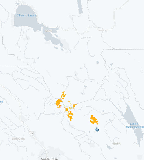
LAKE COUNTY, Calif. – Pacific Gas and Electric Co. said it’s planning to move forward with a public safety power shutoff on Sunday that will impact 89,000 customers in parts of 16 counties, including Lake, due to a strong and dry offshore wind event.event.
The incoming weather conditions prompted the National Weather Service to issue a red flag warning for much of Northern California from Saturday night through Monday, with Cal Fire staffing up around the region due to fire weather concerns, as Lake County News has reported.
PG&E said Saturday evening that approximately 55 Lake County customers – two of them medical baseline – will be impacted. A PG&E map of the impacted areas showed Lake County’s customers will be near the Lake and Napa County line, south of Middletown.
In neighboring Napa County, 216 customers will have their power shut off, with two customers in Sonoma County also to be included, PG&E said.
PG&E said it began making notifications to customers on Thursday about the potential for shutting off power.
The company said its first phase of deenergization will begin at 2 a.m. Sunday and impact approximately 15,000 customers.
The forecast predicts a lull in wind activity during the day on Sunday, and then escalating again Sunday late afternoon. At 4 p.m. Sunday, PG&E will begin its second phase of shutoffs to 74,000 customers, primarily in the Central Sierra region.
The PG&E map for the shutoff indicates power is to be shut off in Lake, Napa and Sonoma counties between 5 and 6 p.m. Sunday, with power restoration expected around noon on Monday.
PG&E said once the high winds subside on Monday morning, it will inspect the deenergized lines to ensure they were not damaged during the wind event, and then restore power.
The company’s plan for power restoration is to conduct it as quickly as possible; the goal is to have power back on for most customers impacted 12 daylight hours after severe weather has passed.
Customers can use an address lookup tool to find out if their location is being monitored for the potential safety shutoff at www.pge.com/pspsupdates.
Email Elizabeth Larson at
The red flag warning will be in effect from 9 p.m. Saturday through 8 a.m. Monday for areas above 2,000 feet in elevation.
The National Weather Service said a red flag warning means that critical fire weather conditions
are either occurring now or will shortly.
The forecast predicts dry east to northeast winds of between 15 and 25 miles per hour will develop over Lake County during Saturday night, and then the remainder of northwest California during Sunday.
The combination of gusty ridgetop winds of up to 40 miles per hour, low humidity and dry fuels will result in critical fire weather conditions through Monday morning, the National Weather Service reported.
The Lake County forecast calls for daytime highs in the 90s through Monday, with nighttime temperatures in the 60s.
The heightened fire weather conditions have firefighters across the region preparing, from those working on the massive August Complex in the Mendocino Shasta-Trinity and Six Rivers National Forests in the north to those on the lookout for the potential for new fires closer to home.
In response to the issuance of the red flag warning, Cal Fire’s Sonoma-Lake-Napa Unit reported that it has increased its staffing on all available engines not already on the 25 major fires across the state.
The unit also reminded residents to prepare their families, have an emergency supply kit ready and have evacuation plans in place in case the event a fire starts near you.
Cal Fire offers more information on fire season preparations on its website.
Email Elizabeth Larson at