NORTHERN CALIFORNIA – Containment numbers on the vast August Complex are continuing to move up.
The August Complex was up to 970,930 acres and 55-percent containment on Friday night, officials reported.
The Forest Service said 583,201 acres of the complex is on the Mendocino National Forest.
Officials said 1,849 personnel remain assigned to the incident, which began on Aug. 17 due to lightning and is burning on the Mendocino, Six-Rivers and Shasta-Trinity National Forests.
The complex is threatening 2,200 structures and has destroyed 108 to date, the Forest Services said.
The Forest Service said substantial work was carried out on Thursday along the southwestern corner of the fire near Big Signal Peak to mop up and secure unburned fuel within the control line.
Fire personnel began assessing areas farther north along the southwestern edge in anticipation of moving and focusing resources in areas with more active fire. Crews pulled eight miles of hose from the interior of the fire, from exterior lines that are fully contained, and contingency or back-up lines, officials said.
Good progress was made along the eastern and southern edge by removing equipment and 60 percent of the hose that will be reallocated to higher priority locations, according to the Forest Service report.
The Forest Service said Friday that crews moved clockwise around the perimeter toward the western area of the fire to gain further information to plan for next steps.
Although resources were moving in that western vicinity, activity continued elsewhere as crews focused on repair of fire suppression activities including dozer and handlines, officials said.
Officials said firefighters will continue patrolling and backhauling of equipment and hose along the eastern and southern edge, where there is good containment.
The structure protection group will remove pumps, hose, and other fire apparatus from areas around Pillsbury Ranch and Rice Creek areas, the Forest Service said.
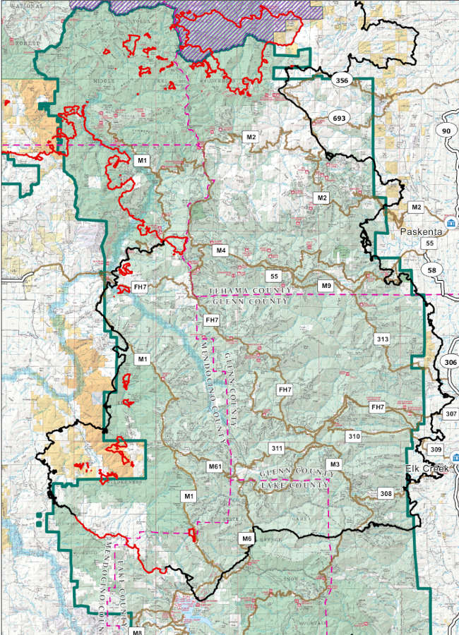
The August Complex South Zone as mapped on Friday, October 2, 2020. Map courtesy of the US Forest Service.
LAKE COUNTY, Calif. – The Lake County Air Quality Management District has issued another air quality alert in response to continuing unhealthy conditions in the air basin due to fires around the region.
Air Pollution Control Officer Doug Gearhart said that due to significant fire activity this week, all of Lake County is forecast to have “unhealthy for sensitive groups” to “unhealthy” air quality through Sunday as smoke settles into the area.
Gearhart said smoke from the Glass fire in Napa and Sonoma counties, the August Complex, and other fires burning in California and Oregon will continue to impact Lake County in the coming weeks.
Current conditions are degraded from the Glass fire and the regional wind pattern transporting smoke into the Lake County Air Basin, he said.
There is a potential for periods of improved air quality and overall improvement as wind patterns change, Gearhart said.
He said early forecast information indicated that a wind shift that started Friday night and continuing into Saturday may push the smoke from the Glass fire out the air basin, but increased activity in the August Complex fire may contribute smoke into the air basin due to the wind direction.
Up-to-date air quality conditions for Lake County can be found at PurpleAir.
What's up for October 2020? Not one, but two, full moons; Mars at opposition; and finding the Andromeda galaxy.
This month brings not just one, but two full moons, at the beginning and end of the month. The full moon that took place on Oct. 1 is called the harvest moon. The harvest moon is the name for the full moon that occurs closest to the September equinox. (One of two days per year when day and night are of equal length.)
Most years the harvest moon falls in September, but every few years it shifts over to October. The name traces back to both Native American and European traditions related, not surprisingly, to harvest time.
At the end of October, on the 31st, we'll enjoy a second full moon. When there are two full moons in a month, the second is often called a blue moon. (There's another, more traditional definition of a blue moon, but this is the most well known.) Note that this is the only two-full-moon month in 2020!
October is a great time for viewing Mars, as the planet is visible all night right now, and reaches its highest point in the sky around midnight. This period of excellent visibility coincides with the event known as opposition, which occurs about every two years, when Mars is directly on the opposite side of Earth from the Sun.
This is also around the time when Mars and Earth come closest together in their orbits, meaning the Red Planet is at its brightest in the sky, so don't miss it.
Spacecraft from several nations are currently on the way to Mars, including NASA's Mars 2020 mission, which is scheduled to land there in February.
Finally this month, it's a great time to try and spot the galaxy of Andromeda. Andromeda is also known as M31. It's a spiral galaxy similar in appearance to our own Milky Way, but slightly larger. Both contain hundreds of billions of stars, and (we think), trillions of planets.
Now we can't see the overall shape of the Milky Way, because we're inside it, so Andromeda gives us a sense of what our galaxy would look like if you could see it from afar.
Andromeda is faint, and best viewed with a telescope, but you can observe it with binoculars or even a cell phone with a good camera on it, even from light-polluted areas. And under very dark skies, it's just barely a naked-eye object. So although it might be a little challenging, it's worth it to see an entire galaxy with your own eyes!
To find the Andromeda galaxy, look to the northeast in the evening sky once it's truly dark. Find the sideways "W" that represents the throne of queen Cassiopeia. To the right of Cassiopeia lies the constellation Andromeda, which includes this string of bright stars.
Moving upward, hang a left at the second of these bright stars, and as you scan back over toward Cassiopeia, you'll notice a faint, fuzzy patch of light. That fuzzy patch is the Andromeda galaxy, located 2 million light-years away. If you manage it, congratulations! You've just gone intergalactic.
You can catch up on all of NASA's missions to explore the solar system and beyond at www.nasa.gov.
Preston Dyches works for NASA's Jet Propulsion Laboratory.
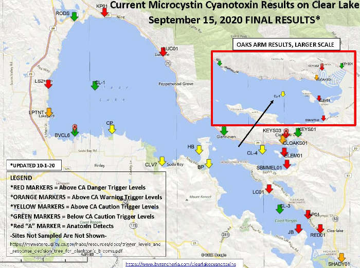
A map of cyanotoxin testing sites on Clear Lake in Lake County, California. Image courtesy of the county of Lake. LAKE COUNTY, Calif. – Newly reported sampling data from numerous sites around Clear Lake have revealed high levels of cyanotoxin.
Public Health Officer Dr. Gary Pace reported that sampling conducted on Sept. 15 detected concerning levels of cyanotoxin at 19 Clear Lake sites, which can be seen on the map above, a larger version of which can be found here.
Big Valley Band of Pomo Indians and Elem Indian Colony conduct regular monitoring on sites across Clear Lake.
On its cyanotoxin monitoring website, Big Valley reported that on Sept. 15 they collected water samples from 24 sites on and in the lake. Cyanobacteria blooms were in most of those locations, so the tribe said it further reviewed those samples to get preliminary toxin data.
Sites showing testing results above the caution and warning trigger levels are:
– Four areas Lakeport: First Street boat ramp, Big Valley Shoreline, Lakeside County Park and a site in the Upper Arm of the lake; – Three areas near Kelseyville: Soda Bay Cove, Horseshoe Bend and Buckingham Park; – Two areas in Clearlake Oaks:the Oaks Arm of the lake and the west side of the Clearlake Keys; and – One site in Clearlake: Shady Acres on Cache Creek.
Sites with results in the danger level are on Lakeshore Drive, north of Lakeport; Lucerne Harbor Park; Keeling Park in Nice; the Elem Colony and the Sulphur Bank mercury mine Superfund site, both in Clearlake Oaks; Lily Cove, Austin Park Beach and Redbud Park in Clearlake; and Jago Bay in Lower Lake.
Pace said people and pets should stay out of the water in those areas. Don’t touch scum in the water or on the shore. Don’t let pets drink the water. Fish and shellfish from those areas should not be eaten.
Symptoms of exposure include skin rashes, eye irritation, diarrhea and vomiting. Pets who contact the toxin can experience seizures and death. Pace said to contact a medical provider or veterinarian if symptoms due to exposure are suspected.
Much of the aquatic plant growth visible in Clear Lake is harmless, and there is no need to be overly concerned about activities in areas of the lake where algae blooms are not present, Pace said.
Centers for Disease Control and Prevention guidance regarding harmful algal blooms can be found here.
“This is a challenging time with the fires, poor air quality, and COVID, but harmful algal blooms can cause significant suffering, so we encourage people to be careful and be aware of the risks,” Pace said.
NORTHERN CALIFORNIA – Weather conditions are expected to heat up over the next few days, which could challenge firefighters on the lines of major wildland fire incidents in northern Lake County and around the region.
The growth of the Glass fire was held to just under 2,100 acres during the course of the day on Thursday, with the fire’s size reaching 58,880 acres by nightfall, with containment remaining at 5 percent, Cal Fire reported.
Cal Fire said 2,517 firefighters are assigned to the incident, along with 361 engines, 49 water tenders, 22 helicopters, 30 hand crews and 83 dozers.
The number of threatened structures rose to 28,835 on Thursday.
Updated damage assessments on Thursday night put the number of structures destroyed at 588, 437 in Napa County and 151 in Sonoma County. Another 110 structures have been damaged, 62 in Sonoma County while Napa County had 48.
Cal Fire said the Glass fire burned actively throughout the day Thursday, with flames making intense runs and aligning with the topography. There also was spotting up to one mile.
Fire activity is expected to increase due to the hot, dry conditions that led to the National Weather Service issuing a red flag warning that’s been extended through Saturday morning across the fire area.
Cal Fire said winds are blowing from the northwest, and the fire area is experiencing near-record temperatures and very low humidity.
On the August Complex to the north, Cal Fire – which is working with the US Forest Service to contain the incident – said it was up to 956,084 acres and 47 percent containment on Thursday night.
The Forest Service said 2,048 personnel are assigned.
That fire, burning on the Mendocino, Shasta-Trinity and Six Rivers National Forests, is threatening 2,200 structures and has destroyed 100, officials said.
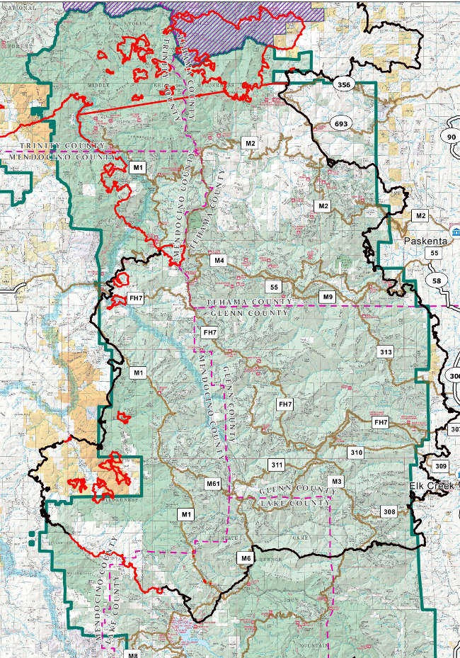
The newly positioned Pacific Northwest Team 2 continued to develop a strategy to move the August Complex South Zone – which includes the Mendocino National Forest lands in northern Lake County – towards full containment, the Forest Service said.
Along with monitoring the east side of the August Complex with ground and air reconnaissance, the Forest Service said fire personnel continued mopping up and monitoring containment lines in the Lake Pillsbury region and to the west.
Crews worked around structures, checked control lines, felled hazard trees along roads and retrieved equipment that was no longer necessary. Fourteen engines were reallocated from the South Zone to the North Zone, officials said.
The Forest Service said a Burned Area Emergency Response Team began work on the eastern side of fire, collecting and analyzing information to document burn severity and to prioritize emergency stabilization measures.
On Thursday, the Forest Service said personnel continued to patrol and monitor containment lines and mop-up areas that still hold residual pockets of heat on the interior of the containment lines. Crews also continued to backhaul equipment from some areas of the fire.
Firefighters in the Lake Pillsbury area will continue work to secure structures. Damage assessments of structures are ongoing, and reports will be updated as areas become safe to evaluate, officials said.
Email Elizabeth Larson at This email address is being protected from spambots. You need JavaScript enabled to view it.. Follow her on Twitter, @ERLarson, or Lake County News, @LakeCoNews.
The August Complex South Zone as mapped on Thursday, October 1, 2020. Map courtesy of the US Forest Service.
California’s Water Year 2020 has come to a close and while Northern California was mostly dry, parts of Southern California experienced above-average precipitation.
The California Department of Water Resources said the water year ended below average and further demonstrated the impact of climate change on the state’s water supply.
“California is experiencing the impacts of climate change with devastating wildfires, record temperatures, variability in precipitation and a smaller snowpack,” said DWR Director Karla Nemeth. “We must continue to invest in our infrastructure to prepare the state to cope with more extreme weather for the state’s needs today and in the future.”
For Water Year 2020, a lack of precipitation resulted in a snowpack of just 50 percent of average on April 1, as measured by the California Cooperative Snow Survey Program, making it the 10th smallest snowpack in California since 1950.
California’s reservoirs received just a third of the water runoff from precipitation and snowmelt that they did during the same time period a year ago.
The impacts of dry conditions were tempered, however, because of good reservoir storage from a wet 2019.
Statewide reservoir storage through the end of September 2020 is projected to be 93 percent of average or 21.5 million-acre feet.
DWR’s annual water year recap, “Water Year 2020: Summary Information,” published below, highlights additional key details of the water year which runs from Oct. 1 to Sept. 30.
Focused on tangible actions to help build a climate-resilient water system, the state recently finalized the California Water Resilience Portfolio outlining almost 150 actions to better prepare our state for long-term water resilience. The continued water year variability is also a reminder to all Californians that we need to be prepared for dry periods. For more information visit: California’s Most Significant Droughts: Comparing Historical and Recent Conditions.
 How to resolve AdBlock issue?