KELSEYVILLE, Calif. – Kelseyville High School Civics teacher Shane Boehlert and his students are hosting a live-streamed Kelseyville Unified School Board Candidates Forum on Wednesday, Sept. 30.
The forum will take place beginning at 7 p.m. on the school district’s Facebook page.
Candidates for Kelseyville Unified School Board on the Nov. 3 ballot are Beniakem Cromwell, Natalie Higley, Mary Beth Mosko and Gilbert Rangel.
“We’ve been working on a lesson about civic engagement, and with the election coming up, I thought this would be a good opportunity for students to get more involved,” said Boehlert.
In preparation for the forum, Boehlert taught students about the role of school boards in local education.
He then encouraged his students to write questions that would help them (and the public) better understand why the candidates chose to run for office and what they hope to achieve.
California Natural Resources Secretary Wade Crowfoot, State Parks Director Armando Quintero and Department of Transportation Director Toks Omishakin on Friday announced a series of actions to identify and redress discriminatory names of features attached to the State Parks and transportation systems.
Agencies also will expand representation and increase transparency around a state committee tasked with recommending changes to geographic names in California.
The moves come in the wake of a national conversation about the names of geographic features, markers and statues affiliated with the Civil War, genocide of Native Americans and other remnants of institutionalized discrimination.
Steps announced Friday dovetail with additional measures announced by Gov. Gavin Newsom to mark Native American Day in California following the governor’s formal apology to Native Americans last year.
“The governor fundamentally changed the way Californians grapple with the difficult beginnings of this state when he formally apologized to California Native Americans last June,” said Governor's Tribal Advisor and Executive Secretary to the Native American Heritage Commission Christina Snider.
“For California Native Americans who have survived generations of depredations against our very existence, these disparaging and dehumanizing names serve as a constant reminder that we were never intended to be part of the California dream,” Snider said. “The leadership of the California Natural Resources Agency and the Department of Transportation in furthering these corrective initiatives demonstrates the state's real commitment to act on the promise of the governor's apology, heal relationships and work to make historically dispossessed communities whole.”
Assembly Member James C. Ramos (D-Highland), the first California Native American elected to the state Legislature, welcomed the announcements.
“Ensuring that state facilities are respectful and inclusive of California’s history and all its people is a much-welcomed step,” Ramos said. “As a Native American, I look forward to the acknowledgement of our presence and culture as well as the education that will occur during a renaming process.”
Secretary Crowfoot said it is past time to revisit historic names that stem from a dark legacy that includes discrimination, violence and inequity.
“Recent protests over racial inequality have spurred a national conversation about institutional and systemic racism in the United States. That conversation includes a new reckoning over monuments, symbols and names found in our public spaces,” Secretary Crowfoot said. “We are committed to continuing this dialogue in an open and transparent way.”
Crowfoot is directing the Natural Resources Agency to expand the membership of the California Advisory Committee on Geographic Names by adding members designated by the Native American Heritage Commission, California State Library, California African American Museum and California Department of Transportation, as well as the legislative Selective Committee on Native American Affairs and Black, Latino and Asian Pacific Islander Legislative Caucuses.
At the same time, the California Department of Parks and Recreation has begun to inventory racist markers and names of features within the State Parks system.
State Parks is developing a process to assess the inventory and solicit input on potential name changes. State Parks also is refining plans in consultation with tribes and other groups to update interpretive signage, exhibits and educational materials for student programs.
“This is a generational moment that calls for the California Department of Parks and Recreation to take stock of and critically examine our state’s historical legacy,” Director Quintero said. “We want every Californian, whether they are first generation or the 500th generation, to feel welcome in parks and see stories shared by all voices.”
As part of Friday’s announcement, Caltrans will carry out a detailed review of all named assets located on the state transportation system and develop a proposal identifying those to be renamed or rescinded.
“Transportation is meant to bring people together, bridge divides, cross immovable boundaries and connect people from all walks of life,” Director Omishakin said. “Caltrans cannot accomplish this mission without addressing the specter of exclusionary, prejudiced place names located throughout the California State Highway system. While long overdue, the department is honored to stand with the Natural Resources Agency and help facilitate a new legacy celebrating diversity, equity and inclusion.”
Dennis Fordham. Courtesy photo. People want their confidential information inside of their living trust to remain confidential.
However, after a trust is executed the settlors often find it necessary to disclose certain limited information in order to retitle assets into the trust, borrow money against trust assets and insure the trust as owner of real property.
Fortunately, third parties requesting information about the trust – like banks, insurance companies and brokerages – only ask for limited information. That is, is the trust revocable or irrevocable; who are the current trustees; what powers does the trustee have; how should trust assets be titled; what is the trust’s taxpayer identification number; and has the trust been amended? A trustee’s certification of trust provides all such information.
In California, section 18100.5 of the Probate Code provides that, “(a) The trustee may present a certification of trust to any person in lieu of providing a copy of the trust instrument to establish the existence or terms of the trust. A certification of trust may be executed by the trustee voluntarily or at the request of the person with whom the trustee is dealing.”
The certification must meet the following requirements: (1) say that the trust has not been revoked, modified, or amended in any manner which would cause the representations contained in the certification of trust to be incorrect; (2) be signed by all of the currently acting trustees of the trust; (3) have a notarial certificate acknowledging each trustee signature.
A certification of trust is helpful, or even required, when dealing with banks, stock transfer agents, brokerage houses, insurance companies, title companies, and other third parties.
Estate planning attorneys often provide one with the trust for the client to copy and provide to retitle and insure trust assets.
If a third party who receives a certification of trust still insists on copies of the trust document to verify its information then the person providing the certification may refuse.
If the matter becomes controversial and goes to court and the court determines that the third party acted in bad faith in requesting the trust documents (section 18100(h) Probate Code) then damages, including attorney’s fees can be awarded.
The initial certification of trust that you receive with your trust, however, becomes stale over time and must be updated. Each time you amend your trust you need a new certification of trust to reflect the amendment.
Even without amendments, an old certification of trust often is unacceptable to third parties seeking to rely on it. Clients call me saying that their bank needs a more recent certification of trust to refinance their home.
Sometimes a client needs to provide a portion (excerpt) of the trust providing information not typically found in a certification of trust.
For the excerpt to be acceptable, the trustee will need to provide a trustee’s certification of the abstract of trust. The certification, made under penalty of perjury under the laws of the state of California, says that the attached abstracted copy of said trust is a true and correct copy of the original trust as executed.
Lastly it is not always necessary to provide either the certification of trust or the abstract of trust. Some third parties are satisfied if the settlor provides them with a copy of the following pages from their trust: first page (title/declaration page), section listing the names of trustees, the signature (execution) page and the notary page.
Accordingly, ask whether this more simplified approach is acceptable. If not, anyone needing to provide a certification of trust by a trustee or a certification of abstract of trust by a trustee may consider calling an estate planning attorney for assistance.
This year’s Arctic sea ice cover shrank to the second-lowest extent since modern record-keeping began in the late 1970s.
An analysis of satellite data by NASA and the National Snow and Ice Data Center, or NSIDC, at the University of Colorado, Boulder shows that the 2020 minimum extent, which was likely reached on Sept. 15, measured 1.44 million square miles.
In winter, frozen seawater covers almost the entire Arctic Ocean and neighboring seas. This sea ice undergoes seasonal patterns of change – thinning and shrinking during late spring and summer, and thickening and expanding during fall and winter.
The extent of summer sea ice in the Arctic can impact local ecosystems, regional and global weather patterns, and ocean circulation. In the last two decades, the minimum extent of Arctic sea ice in the summer has dropped markedly.
The lowest extent on record was set in 2012, and last year’s extent was tied for second – until this year’s.
A Siberian heat wave in spring 2020 began this year’s Arctic sea ice melt season early, and with Arctic temperatures being 14 to 18 degrees Fahrenheit warmer than average, the ice extent kept declining.
The 2020 minimum extent was 958,000 square miles below the 1981-2010 average of yearly minimum extents, and 2020 is only the second time on record that the minimum extent has fallen below 1.5 million square miles.
“It was just really warm in the Arctic this year, and the melt seasons have been starting earlier and earlier,” said Nathan Kurtz, a sea ice scientist at NASA’s Goddard Space Flight Center in Greenbelt, Maryland. “The earlier the melt season starts, the more ice you generally lose.”
Thin ice also melts quicker than thicker floes. Dramatic drops in sea ice extent in 2007 and 2012, along with generally declining summer extent, has led to fewer regions of thick, multi-year ice that has built up over multiple winters. In addition, a recent study showed that warmer water from the Atlantic Ocean, which is typically deep below the colder Arctic waters, is creeping up closer to the bottom of the sea ice and warming it from below.
There are cascading effects in the Arctic, said Mark Serreze, director of NSIDC. Warmer ocean temperatures eat away at the thicker multiyear ice, and also result in thinner ice to start the spring melt season.
Melt early in the season results in more open water, which absorbs heat from the Sun and increases water temperatures.
“As the sea ice cover extent declines, what we’re seeing is we’re continuing to lose that multiyear ice,” Serreze said. “The ice is shrinking in the summer, but it’s also getting thinner. You’re losing extent, and you’re losing the thick ice as well. It’s a double whammy.”
The second-lowest extent of sea ice on record is just one of many signs of a warming climate in the north, he said, pointing to the Siberian heat waves, forest fires, hotter-than-average temperatures over the Central Arctic, and the thawing permafrost that led to a Russian fuel spill.
Kate Ramsayer works for NASA's Goddard Space Flight Center in Greenbelt, Maryland.
LAKE COUNTY, Calif. – Due to a strong and dry offshore wind event forecast for the weekend that has resulted in a red flag warning for much of Northern California, Pacific Gas and Electric Co. said it is planning a public safety power shutoff that could impact a small portion of Lake County’s population.
Due to high winds forecast from early Sunday morning through Monday, the National Weather Service has issued a red flag warning from Lake County and much of the region that’s in effect from 9 p.m. Saturday, Sept. 26, to 8 a.m. Monday, Sept. 28.
Officials said winds are forecasted to reach peak gusts of 35 to 50 miles per hour in the hills above 1,000 feet and low relative humidity values of 10 to 25 percent.
In response to the red flag warning, the Cal Fire Sonoma-Lake-Napa Unit said it has increased its staffing on all available engines not already on the 25 major fires across the state.
PG&E said it’s continuing to monitor the wind event and, given the expected weather conditions, the company began its one-day advance notifications to customers in areas where it may need to proactively turn power off for safety to reduce the risk of wildfire from energized power lines.
The potential public safety power shutoff, or PSPS, expected to start early Sunday morning, could impact approximately 97,000 customers in portions of 15 counties in the Northern Sierra and the northern Sacramento Valley.
PG&E said customers in portions of Alpine, Amador, Butte, Calaveras, El Dorado, Kern, Lake, Napa, Nevada, Placer, Plumas, Shasta, Sierra, Tehama and Yuba counties are being notified.
In Lake County, PG&E said it has notified 55 customers, two of them being medical baseline customers.
PG&E said late Friday afternoon that the anticipated scope and timing of this event has changed from earlier announcements, based on updated weather forecasts that showed stronger wind gusts in a larger portion of PG&E’s service area.
The company said its in-house meteorologists, as well as its Wildfire Safety Operation Center and Emergency Operations Center, continue to monitor conditions closely and additional notifications will be made on Friday to customers who may be impacted by this event. Customers can look up their address online to find out if their location is being monitored for the potential safety shutoff at www.pge.com/pspsupdates or www.pge.com/pspszipcodealerts, PG&E reported.
Email Elizabeth Larson at This email address is being protected from spambots. You need JavaScript enabled to view it.. Follow her on Twitter, @ERLarson, or Lake County News, @LakeCoNews.
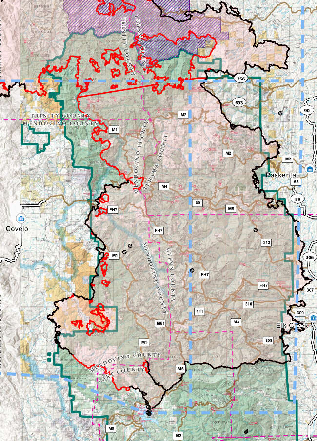
NORTHERN CALIFORNIA – A new team took over management of the August Complex on Friday as fire crews prepared for a wind event expected to impact the fire area this week.
The US Forest Service said Friday that the August Complex increased by nearly 5,000 more acres, to a total of 867,335 acres. Containment rose slightly to 40 percent.
The lightning-caused complex has been burning since Aug. 17 and is anticipated to be fully contained on Nov. 15. It is burning on the Mendocino, Shasta-Trinity and Six Rivers National Forests.
At 7 a.m. Friday, a Type 2 Incident Management Team from the Mendocino National Forest, under Incident Commander Curtis Coots as well as a National Incident Management Team team, assumed command of the South Zone of the August Complex, officials said.
The Forest Service said crews continue to make progress in the Pillsbury Lake area, mopping up after successful firing operations earlier in the week. In addition, crews are working on approved fireline locations in Elk Creek drainage and the Sanhedrin Wilderness to prevent further fire spread to the west.
In the Pillsbury Ranch and Lake Pillsbury basin areas of Lake County, mandatory evacuations remain in place. More information on evacuations across the fire area can be found here.
In advance of a significant change in the forecast for the upcoming weekend – including high winds that have resulted in the National Weather Service issuing a red flag warning for much of Northern California from Saturday night through Monday – firefighters worked on Thursday to improve control lines west and northwest of Lake Pillsbury near Sunset Gap, officials said.
The Forest Service said pumps, hose lays, and sprinklers have been installed and tested, and dozer lines are being improved for use in firing and holding operations that may be needed as weather conditions change.
The east side of the South Zone is fully contained, and is being patrolled with aircraft to ensure that any threats to control lines are identified, officials said.
Officials said residents and property owners may return to their properties within the Mendocino National Forest in Glenn County, but access to the Forest Service closure area for other purposes, including hunting and recreation, is prohibited. Properties accessed via a Forest System road may require a permit from the US Forest Service.
Please contact the Mendocino National Forest at 530-934-3316 for more information.
The August Complex as mapped on Friday, September 25, 2020. Map courtesy of the US Forest Service.
 How to resolve AdBlock issue?