 How to resolve AdBlock issue?
News
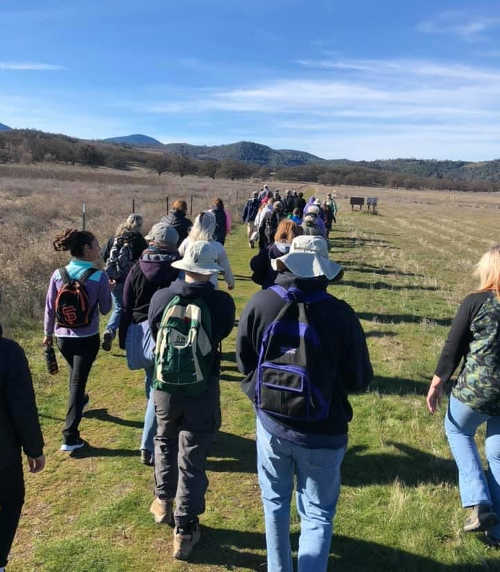
LOWER LAKE, Calif. – Anderson Marsh State Historic Park welcomed 2019 with a hike that drew a large group of participants.
More than 120 people visited the park on a clear and sparkling New Year’s Day to participate in the sixth annual “First Day Hike” at the Park.
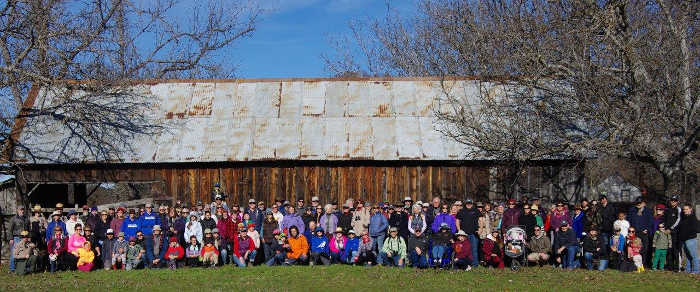
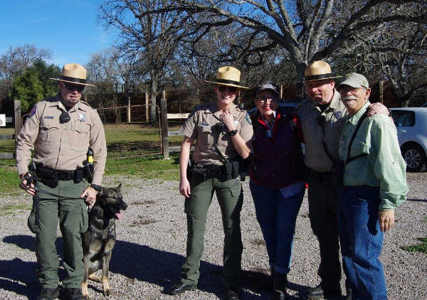
The event was part of the State Parks First Day Hike Program, and was coordinated by the volunteer docents of the Anderson Marsh Interpretive Association.
For more information about guided hikes at Anderson Marsh State Historic Park, visit www.andersonmarsh.org, or contact AMIA at

The pileup occurred on Highway 53 south of Anderson Ranch Parkway just before 1 p.m. Thursday, according to the California Highway Patrol’s Clear Lake Area office.
The CHP said Michael Koroma, 58, of Ukiah stopped his 2006 Mitsubishi Montero within the northbound No. 1 lane of Highway 53, south of Anderson Ranch Parkway, with traffic conditions at the time reported to be moderate.
Kayla Farr, 24, of Hidden Valley Lake was driving a 2012 Ford Fusion northbound on Highway 53 in the No. 1 lane, south of Koroma, and she was behind a large vehicle which blocked her view ahead, the CHP said.
The CHP report said the driver of this larger vehicle ahead of Farr noticed Koroma’s vehicle stopped in the lane and abruptly swerved to the right and avoided a rear-end collision. As a result, once Farr was able to see Koroma’s vehicle, she had a split second to react. She applied the brakes in an effort to avoid rear-ending the stopped vehicle.
Tricia Snider, 48, of Hidden Valley Lake was driving a 2009 Ford Focus and was directly behind Farr’s vehicle. The CHP said Snider was unable to react to the changing traffic conditions ahead and hit the rear of Farr’s vehicle. Farr’s car was pushed to the left from this impact and went along the left side of Koroma’s vehicle.
At the same time, Koroma had exited his vehicle and was standing in Farr’s path of travel. The CHP said Farr’s vehicle hit Koroma as it passed by.
Snider’s vehicle also continued forward and hit the rear of Koroma’s vehicle, the CHP said.
Charleen Long, 33, of Lower Lake was driving the fourth vehicle involved, a 2012 Ford Focus and was directly behind Snider. The CHP said Long was also unable to react and hit the rear of Snider’s vehicle.
Due to Koroma’s major injuries, he was airlifted by REACH air ambulance to Santa Rosa Memorial Hospital, the CHP said.
Farr and Long both had minor injuries, and the CHP said Snider was uninjured. All three were wearing their seat belts.
The CHP said the northbound lanes of Highway 53 were closed for approximately one hour due to the significant cleanup effort.
Neither alcohol nor drugs are believed to be factors in this crash, the CHP said.
Email Elizabeth Larson at

Some images just stick with you; they periodically appear in your mind’s eye and, like a tune you can’t get out of your head, pester you with their persistence.
Perversely, the sadder the subject matter of the image, the more staying power it seems to have.
How many of you who were alive then still recall the images of Jackie Kennedy in Dallas, captured just moments after her husband’s assassination?
Or the images taken on Sept. 11, 2001, of people covered in the same pasty white ash of the twin towers?
Moments like these, captured for posterity by the technology of photography, all contain one key element: pathos.
Stripped down to its mechanical parts, pathos is just a communication technique that appeals to the emotions of an audience. It’s a Greek word, which translates to “suffering” or “emotion” or, most telling of all, to “experience.”
You see, for an appeal to someone’s emotions to be truly effective, it has to reach an individual and elicit feelings that are already buried deep within him. Without empathy, pathos is completely ineffectual.
We remember the blood-spattered Jackie Kennedy because we, too, fear death and – however distantly – can imagine ourselves in a similar situation.
Those dust-caked businessmen and women, the dazed ghosts who stalk the thousands of photographs taken on 9/11, are so maddeningly haunting exactly because they look like we collectively felt that day in America: dazed and afraid, our entire world-view buried in that heap of twisted metal and concrete.
Newspapers and magazines publish these types of images – it’s their stock and trade, and has been so for decades.
Since 1942, Pulitzer Prizes for photography have been awarded to photographers who were able to capture moments in time – moments that embody quintessential elements of the human condition.
You probably already know some of them. The famous photo of the killing of Lee Oswald in 1964; the photo of a starving Ethiopian child, curled on the muddy ground, near death with a vulture perched feet away.
Photographs like these have an important history, one that many individuals contributed to in his/her own way. After all, the first photographer didn’t just start snapping world-class images. An industry has to crawl before it walks, let alone sprints headlong.
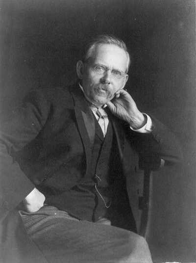
Perhaps the most important of these early photography trailblazers was Danish-American journalist Jacob Riis.
Born in 1849 in Ribe, Denmark, Riis immigrated to America as a young man. Like many immigrants of the time, he struggled to survive, and for a number of years Riis lived hand-to-mouth on the squalid streets of New York City.
Eventually, thanks to the kindness of strangers, he was able to get his feet under him. In 1873, he took a job as a police reporter for a local rag. Charged with covering all the murders, fires, robberies etc. of the Lower East Side, he remained intimately connected to the poverty of the city.
It was during these years as a police journalist that he began to experiment with the use of photography. He wasn’t the first American journalist to submit photographs with his columns, but he was the first to recognize the inherent power of the captured image to move his readers. Riis’s photographs were not merely garnish for his columns.

By the later 1880s, the now-veteran journalist began conducting his own investigation into the living conditions of the crowded tenement buildings that housed so many of the city’s immigrant population. Given his history with homelessness and poverty, this was a story near to his heart.
In order to capture the squalid living conditions inside the dim interiors of the tenements, Riis pioneered the use of flash photography.
With a collection of moving photographs to accompany his writing, Jacob Riis published his now-famous book “How the Other Half Lives.”
When it came out in 1890, Riis’s book shocked the nation; the photographs of half-clothed children huddled in the crumbling rooms of a tenement did not mesh with the gilded ideal most Americans had of themselves.
With the publication of his book sparking new legislation aimed at helping the poor, Riis became the first person to recognize the power of photographs to incite social reform.
Jacob Riis wasn’t done there. For the rest of his career, the man toured his home city and elsewhere in the nation, giving lectures on topics relating to social welfare.
On Jan. 12, 1894, for instance, he gave a public lecture on “The Need of Playgrounds and Open Space” in American cities.
With every lecture, including this one, his now-famously haunting photographs accompanied him, lending weight to his messages of reform.
Despite his groundbreaking work, posterity largely forgot Jacob Riis’s contributions in the years following his death in 1914. It was only after WWII, when the nation had scrapped itself through two world wars and a global depression, that America understood Riis’s raw images of human suffering in their entirety.
Even today, his photographs have the power to take one’s breath away, and remain embedded in one’s mind for a long time thereafter.
Antone Pierucci is curator of history at the Riverside County Park and Open Space District and a freelance writer whose work has been featured in such magazines as Archaeology and Wild West as well as regional California newspapers.

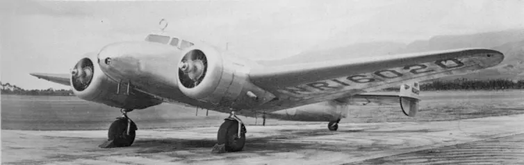
Amelia Earhart’s Lockheed Model 10-E Electra, with advanced navigation equipment mounted above the cockpit. USAF/Wikimedia Commons
When Amelia Earhart took off in 1937 to fly around the world, people had been flying airplanes for only about 35 years. When she tried to fly across the Pacific, she – and the world – knew it was risky. She didn’t make it, and was declared dead in January 1939. In the 80 years since then, many other planes have been lost around the world and never found again – including the 2014 disappearance of Malaysia Airlines Flight 370, over the Indian Ocean.

Amelia Earhart, missing and declared dead Jan. 5, 1939. Underwood & Underwood/Wikimedia Commons

As flight instructors and aviation industry professionals, we know that increasingly advanced technologies are getting better at tracking planes, even across great expanses of water far from land. These systems allow aircraft to navigate much more easily, and many allow real-time flight tracking across much of the globe.
Getting from place to place
From the early years of aviation up until about 2000, the main way pilots navigated was by playing connect-the-dots across a map. They would use radio direction-finding equipment to follow a route from an airport to a radio-transmitting beacon at a fixed location, and then from beacon to beacon until reaching the destination airport. Various technologies made that process easier, but the concept was still the same. That system is still in use, but decreasingly so as new technologies replace it.

Ground-based radio beacons are found at airports and along major flight routes. Sabung.hamster/Wikimedia Commons, CC BY-SA

In the first few years of the 21st century, pilots for major airlines began to use the United States’ Global Positioning System and other similar systems that use signals from orbiting satellites to calculate the plane’s position. GPS is more accurate, letting pilots land easily in bad weather conditions, without the need for expensive ground-based radio transmitters. Satellite navigation also lets pilots fly more directly between destinations, because they need not follow the routes from one radio beacon to the next.

A diagram of what a constellation of position-finding satellites looks like. NOAA/Wikimedia Commons

There are six satellite-based navigation systems in operation: GPS, run by the United States; Galileo, run by the European Union and the European Space Agency; and the Russian GLONASS cover the whole planet, and China’s BeiDou system is expected to span the globe by 2020. India’s NAVIC covers the Indian Ocean and nearby areas; Japan has begun operating the QZSS system to improve navigation in the Pacific.
The systems operate independently of each other, but some satellite navigation receivers can merge data from more than one of them simultaneously, providing pilots with extremely accurate information about where they are. That can help them get where they’re going, rather than going missing.
Tracking aircraft
When planes do get lost, the company or country responsible for them often starts searching; some efforts, like the search for MH 370, include many nations and businesses.
When all is going well, most planes are tracked by radar, which can also help air traffic controllers prevent midair collisions and give pilots directions around severe weather. When planes fly beyond the range of land-based radar, like on long-haul trips over oceans, though, they’re tracked using a method devised more than 70 years ago: Pilots periodically radio air traffic control with reports on where they are, what altitude they’re flying at and what their next navigation landmark is.
Over the past few years, a new method has been rolling out around the world. Called “Automatic Dependent Surveillance – Broadcast,” the system sends automatic position reports from airplanes to air traffic controllers and nearby aircraft, so everyone knows who’s where and avoids collisions. By 2020, the FAA will require most aircraft in the U.S. to have an ADS-B system, which is already mandatory in several other countries.
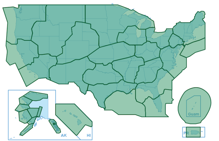
Coverage for ADS-B service in the U.S. FAA

At the moment, though, ADS-B flight tracking doesn’t cover remote areas of the world because it depends on ground-based receivers to collect the information from planes. A space-based receiver system is being tested, which could eventually cover the entire planet.
In addition, many airplane manufacturers sell equipment that includes monitoring and tracking software: for instance, to analyze engine performance and spot problems before they become severe. Some of this equipment can transmit real-time data on the location of the aircraft while it’s in flight. Data from those systems were used in the search for MH 370, and also gave investigators early insight into the 2015 Germanwings 9525 crash in the French Alps, before the plane’s “black box” flight data recorder was found.
GPS, ADS-B and other navigation and tracking systems might have helped save, or at least find, Amelia Earhart and her navigator, Fred Noonan – either by preventing them from getting lost in the first place or by directing rescuers to their location after the plane went down. Eight decades later, planes still go missing – but it’s getting harder to fly off the map.![]()
Brian Strzempkowski, Assistant Director, Center for Aviation Studies, The Ohio State University and Shawn Pruchnicki, Lecturer, Center for Aviation Studies, The Ohio State University
This article is republished from The Conversation under a Creative Commons license. Read the original article.

Data from NASA's New Horizons spacecraft, which explored Kuiper Belt object Ultima Thule earlier this week, is yielding scientific discoveries daily.
Among the findings made by the mission science team in the past day are:
– Initial data analysis has found no evidence of rings or satellites larger than one mile in diameter orbiting Ultima Thule.
– Data analysis has also not yet found any evidence of an atmosphere.
– The color of Ultima Thule matches the color of similar worlds in the Kuiper Belt, as determined by telescopic measurements.
– The two lobes of Ultima Thule – the first Kuiper Belt contact binary visited – are nearly identical in color. This matches what we know about binary systems which haven't come into contact with each other, but rather orbit around a shared point of gravity.
"The first exploration of a small Kuiper Belt object and the most distant exploration of any world in history is now history, but almost all of the data analysis lies in the future," said Alan Stern of the Southwest Research Institute in Boulder, Colorado.
Data transmission from New Horizons will pause for about a week while the spacecraft passes behind the sun as seen from here on Earth.
Data transmission resumes Jan. 10, starting a 20-month download of the spacecraft's remaining scientific treasures.
"Those of us on the science team can't wait to begin to start digging into that treasure trove," said Stern.
New Horizons completed the farthest flyby in history when it came within about 2,200 miles (3,500 kilometers) of Ultima Thule at 12:33 a.m. EST on Jan. 1, zooming past the object at more than 32,000 miles (51,000 kilometers) per hour.
The Johns Hopkins Applied Physics Laboratory in Laurel, Maryland, designed, built and operates the New Horizons spacecraft, and manages the mission for NASA's Science Mission Directorate.
The Southwest Research Institute, based in San Antonio, leads the science team, payload operations and encounter science planning. New Horizons is part of the New Frontiers Program managed by NASA's Marshall Space Flight Center in Huntsville, Alabama.
Follow the New Horizons mission on Twitter and use the hashtags #UltimaThule, #UltimaFlyby and #askNewHorizons to join the conversation. Live updates and links to mission information are also available on http://pluto.jhuapl.edu and www.nasa.gov.

LAKEPORT, Calif. – The Lakeport Police Department is offering a brand new service to the community.
Starting Monday, Jan. 7, the Lakeport Police Department will have a safe medication disposal collection site available at the police station at 2025 S. Main St.
The safe medication disposal safe was donated to the agency by the Rite Aid Foundation KidCents Project, which is committed to supporting the safety and well-being of children in communities.
Over the past couple of years, members of the community have asked the police department for assistance in disposing of unwanted or expired prescription or over-the-counter medications. Police officials said this donation assisted them in being able to collect the medication for proper disposal.
Examples of what Lakeport Police will accept include all over-the-counter or prescription medication in pill, tablet or capsule form, including schedule II-V controlled and non-controlled substances.
Examples of items they will not accept with this program are illegal drugs, needles, liquids, inhalers or aerosol cans.
The police department said the purpose of this program is to keep the community safe by removing unwanted or expired medications from homes or other locations and away from children.
There is no cost for community members to dispose of the described medications at the police station and they will not collect information on people disposing of them.
Medications will be accepted each business day, Monday through Thursday, between 9 a.m. and 4 p.m.
Persons bringing in medications will be required to check in with a department staff member so that they can verify that only acceptable items are being placed in the container.
Additionally, all medications shall be in their original container, other suitable plastic pill container or sealed plastic freezer bag.
If the prescription medications are in the original container, it’s recommended that personal information be removed from the label.