 How to resolve AdBlock issue?
News

Curious Kids is a series for children of all ages. If you have a question you’d like an expert to answer, send it to
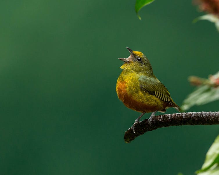
Birds are some of the most attractive creatures on earth. Who doesn’t like to watch a Blue Jay, Cardinal or Baltimore Oriole going about its business?
But the beauty of birds isn’t just their looks – it’s also their noises. Bird songs are among nature’s most distinctive and musically satisfying sounds. Why do birds spend so much time and energy singing?
There are two main purposes, and they are connected. First, male birds sing to mark territories. A singing bird is saying, “This place is mine, and I’m willing to defend it, especially from others of my species.” He may patrol his chosen space and sing often, either from the middle or the edges of what he considers his turf.
The second purpose of singing is to attract a mate for nesting. Female birds often choose their mates based on some blend of visual and vocal cues. Even male birds with beautiful breeding-season plumage can have trouble finding mates if their songs don’t measure up.
Each bird species typically has its own unique song. That allows an individual bird to hear a song and recognize whether the singer is from its own species.
Birds are most vocal during nesting season. For example, in Florida where I live, Cardinals live year-round. They usually start singing in January, just a few weeks after the days begin to get longer. After the nesting period is over, birds sing much less and their territories break down.
Many species of North American birds migrate with the seasons instead of staying in one place all year. As they fly south in the fall, they make little “chip” notes or “contact calls” that allow them to stay in touch with other birds.
In many species only male birds sing, but in others, both males and females sing. And some birds don’t sing at all. For example, vultures and storks can barely produce any sound – let alone something musical enough that we would call it a song.
Learning to identify birds by their songs is as much fun as spotting them by sight. In fact, good ears are often as important as good eyes in appreciating the birds you encounter. Take off your headphones and listen to your neighborhood birds – especially when they are active in the morning or evening. You’ll be surprised by what you hear.
Hello, curious kids! Do you have a question you’d like an expert to answer? Ask an adult to send your question to
Please tell us your name, age and the city where you live. We won’t be able to answer every question but we will do our best.![]()
David Steadman, Curator of Ornithology, Florida Museum of Natural History, University of Florida
This article is republished from The Conversation under a Creative Commons license. Read the original article.
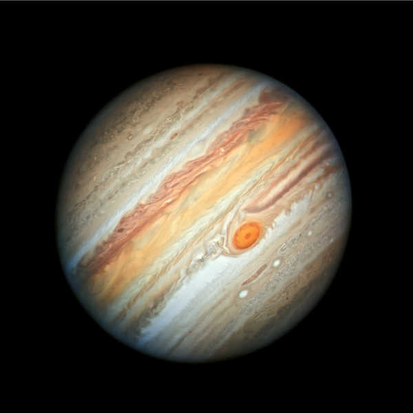
A new Hubble Space Telescope view of Jupiter, taken on June 27, 2019, reveals the giant planet's trademark Great Red Spot, and a more intense color palette in the clouds swirling in Jupiter's turbulent atmosphere than seen in previous years. The colors, and their changes, provide important clues to ongoing processes in Jupiter's atmosphere.
The bands are created by differences in the thickness and height of the ammonia ice clouds. The colorful bands, which flow in opposite directions at various latitudes, result from different atmospheric pressures. Lighter bands rise higher and have thicker clouds than the darker bands.
Among the most striking features in the image are the rich colors of the clouds moving toward the Great Red Spot, a storm rolling counterclockwise between two bands of clouds. These two cloud bands, above and below the Great Red Spot, are moving in opposite directions.
The red band above and to the right (northeast) of the Great Red Spot contains clouds moving westward and around the north of the giant tempest. The white clouds to the left (southwest) of the storm are moving eastward to the south of the spot.
All of Jupiter's colorful cloud bands in this image are confined to the north and south by jet streams that remain constant, even when the bands change color. The bands are all separated by winds that can reach speeds of up to 400 miles (644 kilometers) per hour.
On the opposite side of the planet, the band of deep red color northeast of the Great Red Spot and the bright white band to the southeast of it become much fainter. The swirling filaments seen around the outer edge of the red super storm are high-altitude clouds that are being pulled in and around it.
The Great Red Spot is a towering structure shaped like a wedding cake, whose upper haze layer extends more than 3 miles (5 kilometers) higher than clouds in other areas. The gigantic structure, with a diameter slightly larger than Earth's, is a high-pressure wind system called an anticyclone that has been slowly downsizing since the 1800s. The reason for this change in size is still unknown.
A worm-shaped feature located below the Great Red Spot is a cyclone, a vortex around a low-pressure area with winds spinning in the opposite direction from the Red Spot. Researchers have observed cyclones with a wide variety of different appearances across the planet. The two white oval-shaped features are anticyclones, like small versions of the Great Red Spot.
Another interesting detail is the color of the wide band at the equator. The bright orange color may be a sign that deeper clouds are starting to clear out, emphasizing red particles in the overlying haze.
The new image was taken in visible light as part of the Outer Planets Atmospheres Legacy program, or OPAL. The program provides yearly Hubble global views of the outer planets to look for changes in their storms, winds and clouds.
Hubble's Wide Field Camera 3 observed Jupiter when the planet was 400 million miles from Earth, when Jupiter was near "opposition" or almost directly opposite the Sun in the sky.
The fire began just before 1 p.m. Thursday on Soda Bay Road at Golf Drive, in the Black Forest.
Cal Fire said its investigators were immediately dispatched to the Golf fire and began working to determine the origin and cause of the fire.
After “a meticulous and thorough investigation,” Cal Fire said it has determined that the Golf fire was caused by an improperly discarded cigarette.
When needing to discard a cigarette, Cal Fire reminds members of the public to use a deep, sturdy ashtray and place it away from anything that can burn.
“Do not discard cigarettes in vegetation such as mulch, potted plants or landscaping, peat moss, dried grasses, leaves or other things that could ignite easily,” Cal Fire said.
“Before you throw away any cigarette butts and ashes, make sure they are out. Dousing them in water or sand is the best way to do that. Never throw cigarettes out of vehicles, always discard them in an ashtray or a container designed for cigarette disposal,” the agency’s report on the fire’s cause said.
Cal Fire’s latest report on the fire’s conditions put it at 20 acres with containment at 80 percent.
One firefighter on the incident has suffered a minor injury, officials said.
No structures have been destroyed or damaged.
All evacuations were lifted on Friday, and on Saturday the Lake County Sheriff’s Office said the road closures on Soda Bay Road in Buckingham were lifted as of noon, but motorists were asked to remain alert for emergency personnel and equipment that may still be working in the area.
Crews on Saturday continued to construct control line and extinguish hot spots within the fire
Area, Cal Fire said.
The firefighting work has been aided by better weather conditions, including higher humidities and lower temperatures, officials said.
Cal Fire said overnight winds tested the control lines with no extension outside the perimeter.
Email Elizabeth Larson at
KELSEYVILLE, Calif. – Firefighters are close to reaching full containment on the wildland fire that began burning on Thursday afternoon on the side of Mount Konocti.
Cal Fire said Friday evening that the Golf fire was up to 75 percent containment, with the agency rolling back its estimate of the size from 33 acres to 20.
The acreage change was the result of accurate mapping during daylight hours, combined with getting a better picture of the site that had been obscured by dense canopy and heavy timber, Cal Fire said.
The fire began just before 1 p.m. Thursday at Soda Bay Road and Golf Drive in the Black Forest, pushing up and away from the Buckingham subdivision but moving uphill aggressively in a direction that put the homes in Riviera West and Riviera Heights in its path.
That led to an evacuation order for Riviera West and evacuation warning for Riviera Heights on Thursday afternoon, with Pacific Gas and Electric asked to cut power to 260 customers in Riviera West.
No homes were damaged or destroyed, and the Lake County Sheriff’s Office lifted both the evacuation order and the warning early Friday afternoon, shortly afterPG&E reported that the power had been restored to Riviera West homes.
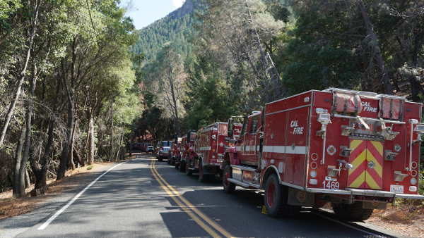
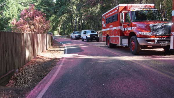
By Friday afternoon, most road closures also had been lifted, with the exception of Soda Bay Road from Golf Drive to Crystal Drive.
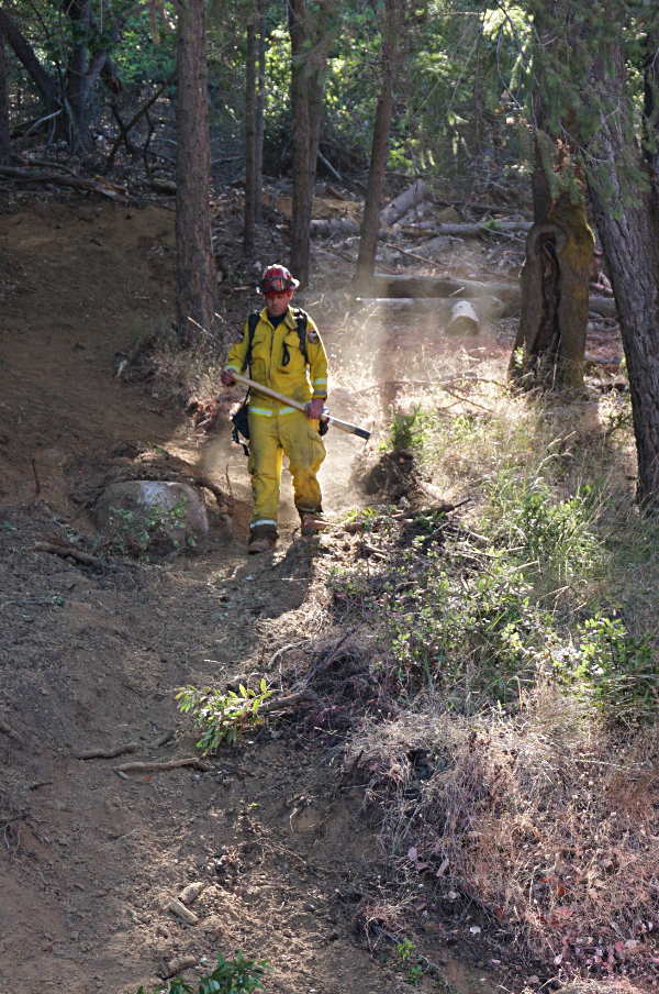
Along that stretch of road on Friday, numerous fire engines, crew transports and the trucks belonging to overhead personnel filled the roadway while firefighters continued to hike into the steep hillsides of the Black Forest to strengthen containment lines.
Fire Prevention Specialist Bruce Lang of Cal Fire was at the scene on Friday afternoon, with the fire leading to him having to cancel the Smokey Bear birthday party he was set to lead at Clear Lake State Park later in the evening.
Lang said the fire had been driven both by steep terrain and winds on Thursday.
“Mount Konocti can give you some problems with the winds,” he said.
There have been long standing concerns about fire danger on the mountain and the danger it poses to the thousands of homes along its base and slopes. On Thursday, as the fire began to push toward homes and evacuations were called, those fears seemed about to come true.
However, Lang said the combination of air resources – including the tankers that dropped retardant and the helicopters that made countless water drops, pulling water from nearby Clear Lake – plus the ground crews helped stop the fire before it could cause major damage to homes or wildland.
On Friday, Lang said they couldn’t have asked for better weather conditions. That was thanks to a low pressure system moving across interior Northern California, which offered cooler and more humid weather conditions, along with little daytime wind, conditions that Lang said were highly favorable to the firefighting work. Earlier that day, he said there had even been a light sprinkling of raindrops.
On Soda Bay Road, below the firefighting line, it was hard to see through the terrain and trees to where personnel were at work.
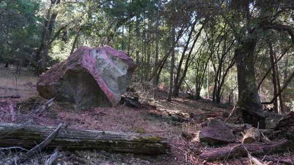
Across the way, at the Buckingham golf course, where golfers were busy on the course throughout the afternoon, a thin white column of smoke could be seen rising from the fire area, which stood out from the hillside both because of the burned area and due to the lines of pink fire retardant dropped the previous day by the tankers.
Up close, thanks to the retardant lines, parts of the Black Forest, including some of its landmark jutting boulders, had turned pink. The pink retardant also was across the road and on nearby homes. Piles of fire hose also dotted the side of the road.
In recent days, crews had been doing vegetation removal along Soda Bay Road near where the fire started, and on Friday there remained numerous green dumpsters filled with cut branches, alongside large slash piles. Several area residents have contacted Lake County News about their concerns that the vegetation removal, including the use of chainsaws, was connected to the fire.
Cal Fire said the cause remains under investigation.
The resources that remained assigned to the fire as of Friday evening included 15 engines, three water tenders, three helicopters, five hand crews, two dozers and 155 personnel, Cal Fire said.
Cal Fire said firefighters will continue strengthening the containment lines throughout the night.
Along with Cal Fire, cooperating agencies include the Bureau of Land Management, which manages the Black Forest, Kelseyville Fire Protection District, Lake County Fire Protection District, Lakeport Fire Protection District, South Lake Fire Protection District, Marin County Fire Department, city of Colusa, Williams Fire Protection Authority, City of Lake County Sheriff’s Office, PG&E and the California Highway Patrol.
Email Elizabeth Larson at
The mosquitoes, Culex tarsalis (western encephalitis mosquito), were collected near Lower Lake on Aug. 6.
“This is the first detection of West Nile virus this year in Lake County,” said Jamesina Scott, Ph.D., district manager and research director of the Lake County Vector Control District. “Mosquitoes develop in water, so you can protect yourself and your family from mosquito bites by dumping out standing water. Take a walk around your yard today and look for places that might hold water like buckets, toys, and boats and dump out any water you find. If you have a pond, livestock watering trough, or water feature that can’t be drained, then contact the District and we can provide free mosquito-eating fish to prevent mosquitoes from growing there.”
“If you plan to be outside when mosquitoes are active, use insect repellent applied according the directions on the label and reapply as directed,” said Dr. Erin Gustafson, Lake County Deputy Health Officer.
Dr. Gustafson also encourages residents, “Wear long pants and long sleeves, and residents can treat items, such as boots, pants, socks, and tents, with permethrin or buy permethrin-treated clothing and gear. Residents should also sleep under a mosquito bed net if air conditioned or screened rooms are not available or if sleeping outdoors.”
The district asks residents to reduce their risk of contracting West Nile virus and other mosquito-borne diseases by:
– Dumping or draining standing water to prevent mosquitoes. Mosquitoes need water to complete their life cycle.
–Defending yourself. Use repellents containing DEET, Picaridin, IR3535, or Oil of Lemon Eucalyptus. Follow the label directions.
– Avoiding the outdoors when mosquitoes are present, typically dawn and dusk.
So far this year, West Nile virus activity only has been detected in Lake County in the two mosquito samples.
West Nile virus in humans
Statewide, 21 California counties have detected WNV this year, mainly in mosquitoes. As of Aug. 2, six human cases of West Nile virus illness have been reported in California residents this year.
No vaccine or specific antiviral treatments for West Nile virus infection in humans are available.
Most people – 80 percent – with West Nile virus do not develop any symptoms.
About 1 in 5 people who are infected develop a fever with other symptoms such as headache, body aches, joint, pains, vomiting, diarrhea, or rash. Most people with this type of West Nile virus disease recover completely, but fatigue and weakness can last for weeks or months.
About 1 in 150 people infected with West Nile virus will develop severe illness which causes inflammation of the membranes that surround the brain and spinal cord.
Symptoms of severe illness include high fever, headache, neck stiffness, disorientation, coma, tremors, convulsions, muscle weakness, vision loss, numbness, and paralysis. Recovery from severe illness can take several weeks or months. Some effects to the central nervous system (brain and spinal cord) might be permanent.
In about 1 out of 10 people who develop severe illness affecting the central nervous system, the infection can be fatal. People over age 60 and those with certain medical conditions, such as diabetes, cancer, hypertension, kidney disease, and people have received organ transplants are at greatest risk of severe disease.
The most recent confirmed case of human WNV infection in Lake County was in 2016.
See your healthcare provider if you develop the symptoms described above. Your healthcare provider can order tests to look for West Nile virus infection. To learn more about testing, visit the CDC’s Healthcare Providers page.
Vector Control offers information, resources
Mosquitoes that transmit WNV develop in the water in out-of-service swimming pools and spas, animal watering troughs, ornamental ponds, rain barrels and other sources of standing water.
Residents can get mosquito-eating fish for these sources free of charge from the Vector Control District. Swimming pools and spas that aren’t being maintained can produce thousands of biting mosquitoes every day. Residents can help reduce mosquitoes in their neighborhoods by reporting unmaintained pools to the District, Dr. Scott recommends.
Anyone with questions or who would like help with a mosquito problem, including reporting a neglected pool or spa, should contact the Lake County Vector Control District at 707-263-4770 or visit the district Web site at www.lcvcd.org .
For more information about West Nile virus, visit http://www.westnile.ca.gov/ .
Information about mosquito repellents can be found on the US Centers for Disease Control and Prevention Web site at http://www.cdc.gov/westnile/faq/repellent.html .
As an environmental scientist, I’ve done plenty of hiking in the western U.S. – always with a map, water bottle and list of water sources. In dry areas it’s always smart to ration water until you get to a new source. Sometimes a stream has dried up for the season, or a pond is too scummy to drink from, so your supply has to stretch further than planned.
On one memorable hike, I found that a water source was dry. The next one, three miles later, was dry too. And the one after that had a dead bear carcass in it. While one dry water source was tolerable, several in a row created a serious problem.
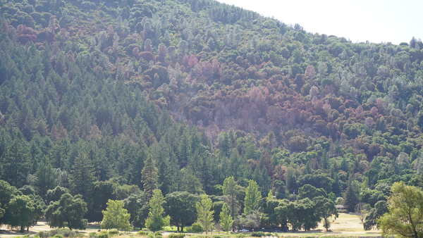
Something similar is happening to snow resources in the western United States. Scientists have long known that the warming temperatures associated with climate change are diminishing the region’s snowpack, with more precipitation falling as rain, rather than snow. That’s a problem because snowpack is a critical resource, acting as a natural reservoir that stores winter precipitation.
In a newly published study, my colleagues John Abatzoglou, Timothy Link, Christopher Tennant and I analyze year-to-year variations of future snowpack to see how frequently western states can expect multiple years in a row of snow drought, or very low snow. We find that if climate change continues relatively unabated, consecutive years with snow drought conditions will become much more common, with impacts on cities, agriculture, forests, wildlife and winter sports.
Snow droughts affect ecosystems and people
Snowpack is a critical resource in the western U.S. and Canada. Snow melts and runs off in spring and summer, when cities, farms and forests need water. It supports animals such as wolverines that depend on snow, and underpins winter sports industries.
Multiyear snow droughts are akin to drawing down a bank account for some of these important systems. For example, lower snow years typically have longer summer periods with low soil moisture. Trees and other plants may be able to survive these stresses for one year, but longer stretches could lead to increases in forest mortality.
These periods also test western reservoirs, many of which are managed for dual purposes: Storing spring runoff for times of high water demand, and holding space for potential floodwaters. The amount of space allocated to storage versus flood control varies by time of year.
Water managers may need to update these rules to account for higher chances of snow drought or changes in the timing of snowmelt runoff. Rainfall is also a factor, and at least in California, total precipitation is projected to become increasingly variable from year to year with climate change.
Snow droughts also affect the winter tourism industry. Ski resorts in lower-elevation areas with increasingly warm winters may be able to survive one year of poor snow conditions, but multiple low-snow years in a row may threaten their viability.

Projecting future snows
In our study we defined snow droughts as years with snowpack low enough to have historically occurred only one out of every four years or less. Such events occurred recently in the Sierra Nevada between 2012-2015 and the Cascades in 2014-2015.
Researchers created the dataset we used by first running 10 global climate models – computer programs that simulate historical and future climate based on a number of factors, including atmospheric carbon dioxide concentrations.
Like all climate projections, our estimates include some uncertainty. Each global climate model produces slightly different results; by analyzing all 10, we can be more confident in our conclusions when most of them agree on projected changes.
These models produce data with a resolution of hundreds of kilometers. That doesn’t provide detailed information about conditions in the mountainous parts of the western U.S., where conditions vary dramatically over much smaller scales. To solve this problem, the modelers used a process called downscaling to develop results with much higher spatial resolution – in this case, to grid cells that measured about six kilometers on a side.
Then they loaded this climate data into a hydrologic model that estimates daily snow accumulation and melt. We used the results from this hydrologic model to calculate changes in snowpack in future conditions, relative to historical conditions.
Fewer big snow years
Today, back-to-back snow droughts in the western U.S. occur around 7% of the time. By mid-century, if greenhouse gas emissions continue to increase, our results predict that multiyear snow droughts will occur in 42% of years on average.
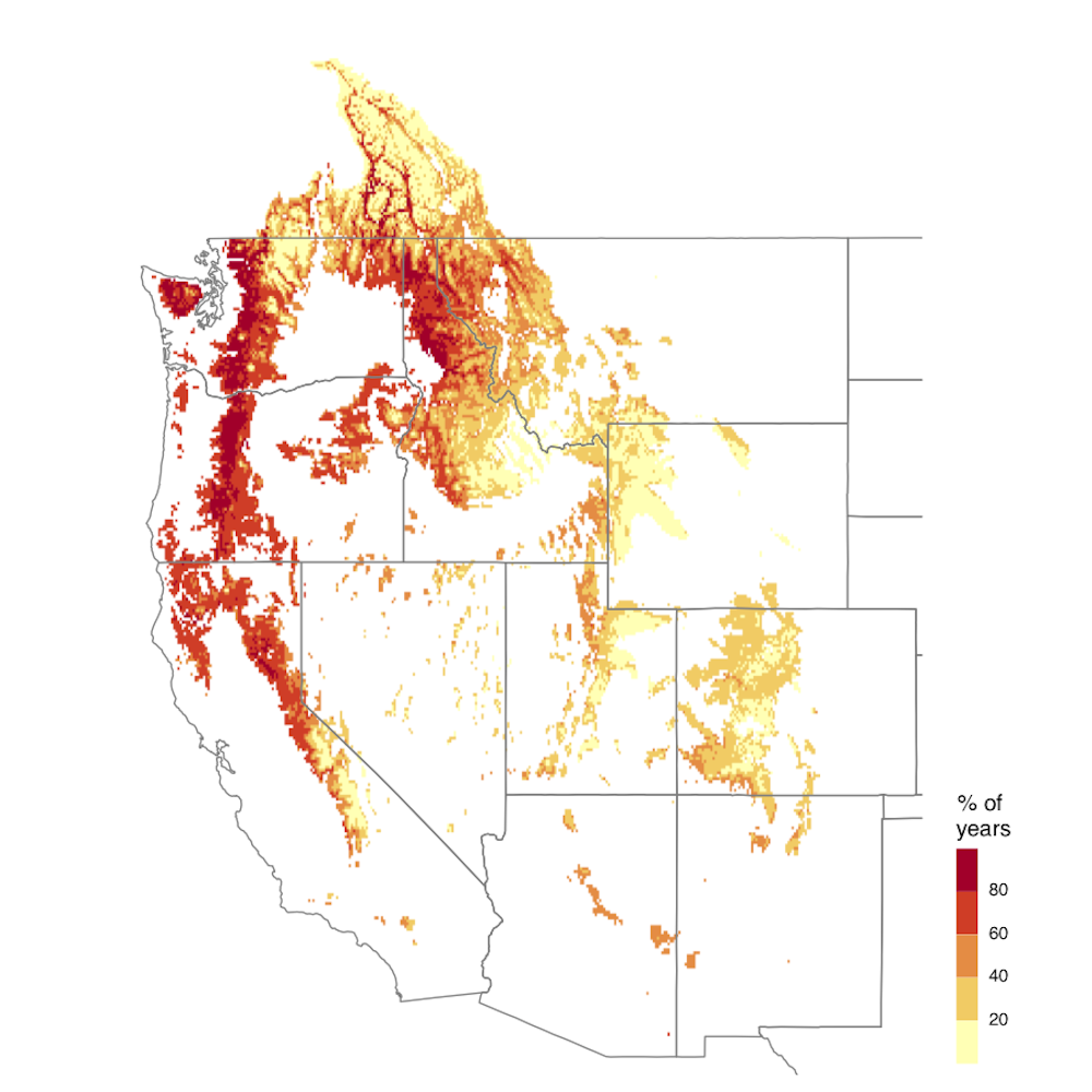
In addition to projecting more frequent snow droughts, we also found that peak snowpack is projected to decline and become less variable in a warming climate across much of the mountainous West. This will mean there will be fewer very high-snow years to offset the impacts of low-snow years.
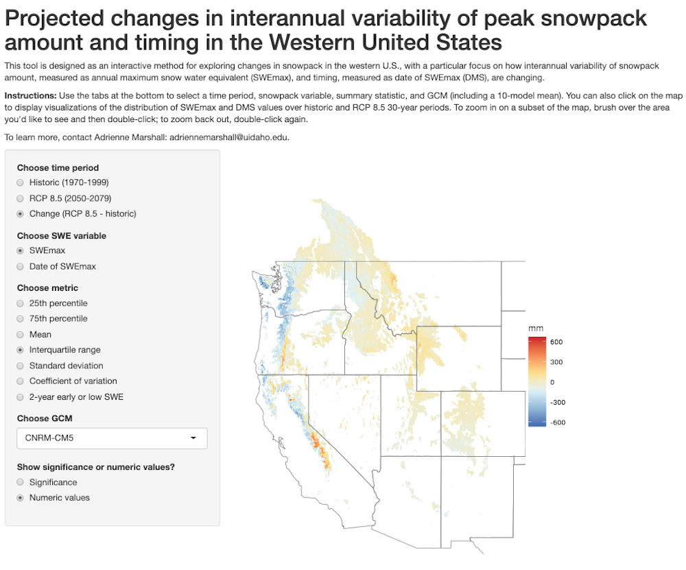
Another feature of changing snowpack is the timing of when it accumulates and melts. Generally, as the climate warms snow is melting earlier, which leads to earlier spring runoff and less water available in summer.
In our study, we also found that in many places the timing of peak snowpack is projected to become more variable from year to year. We developed an interactive tool that allows users to explore this data on their own.
Planning for the future
Our results are based on a future in which the world continues to rely on fossil fuels. Reducing greenhouse gas emissions would limit the impacts on western snowpack that we project.
On the hike where all of my water sources were dry, I was saved by a kind stranger. The trail intersected a road, and a passing driver gave me some water. Global climate change won’t be solved so easily: Addressing these issues will require major coordinated efforts to limit future warming and manage Earth’s natural resources strategically to provide for society’s needs and environmental conservation.![]()
Adrienne Marshall, Postdoctoral Fellow in Forest, Rangeland, and Fire Sciences, University of Idaho
This article is republished from The Conversation under a Creative Commons license. Read the original article.