How to resolve AdBlock issue?
News
- Details
- Written by: Lake County News reports
License points for distracted driving (AB 47, Daly; 2019): Using a cell phone in a handheld manner while driving is currently punishable by a fine. Beginning July 1, 2021, violating the hands-free law for a second time within 36 months of a prior conviction for the same offense will result in a point being added to a driver’s record. This applies to the violations of talking or texting while driving (except for hands-free use) and to any use of these devices while driving by a person under 18 years of age.
Unattended children in motor vehicles (AB 2717, Chau): Exempts a person from civil or criminal liability for trespassing or damaging a vehicle when rescuing a child who is 6 years old or younger and who is in immediate danger from heat, cold, lack of ventilation, or other dangerous circumstances. The law takes effect Jan. 1, 2021.
“Move Over, Slow Down” amendments (AB 2285, Transportation Committee): Extends the provisions of the “Move Over, Slow Down” law currently in place on freeways to also apply to local streets and roads so drivers approaching a stationary emergency vehicle displaying emergency lights, including tow trucks and Caltrans vehicles, must now move to another lane when possible, or slow to a reasonable speed on all highways, not just freeways. The law is effective Jan. 1, 2021.
Emergency vehicles (SB 909, Dodd): Allows authorized emergency vehicles to use a “Hi-Lo” warning sound. This distinctive sound, different than a siren, would be used to notify the public of an immediate need to evacuate an area in an emergency. The CHP is currently developing regulations to standardize the Hi-Lo warning sound statewide. Until the regulations are adopted, law enforcement agencies can use the Hi-Lo warning sound by obtaining a permit from the CHP. The law went into effect Sept. 29, 2020.
The mission of the CHP is to provide the highest level of safety, service and security.
Census Bureau’s characteristics of new housing offers a peek into the nation’s new homes this decade
- Details
- Written by: PHILIP THOMPSON

The average square footage of new homes sold in the United States increased from 2,457 in 2010 to 2,724 in 2015 but dropped in 2019 to 2,518, according to the U.S. Census Bureau’s Characteristics of New Housing.
The report is based on data collected in the Survey of Construction (SOC) which is partially funded by the Department of Housing and Urban Development (HUD). It provides national and regional details on new privately owned single-family and multifamily residential structures.
Characteristics include square footage, number of bedrooms and bathrooms, types of wall material, parking, sales prices and more.
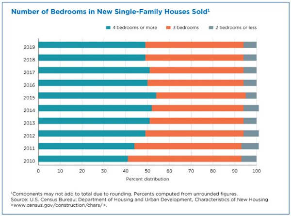
No downsizing
Despite the decline in average square footage, the share of homes with four bedrooms or more that were sold increased from 41 percent in 2010 to 49 percent in 2019.
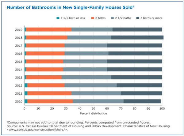
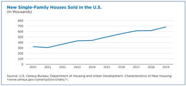
In 2010, 27 percent of the 323,000 new single-family homes sold in the United States had three or more bathrooms. In 2019, 36 percent of the 683,000 U.S. homes sold had three or more bathrooms.
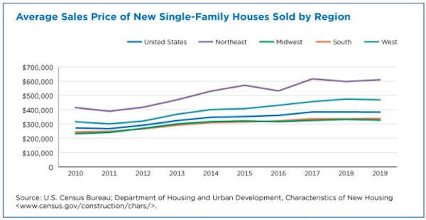
Rising prices
The average sales price of new single-family homes sold in 2019 was $383,900, up from $272,900 in 2010. Prices are not adjusted for inflation.
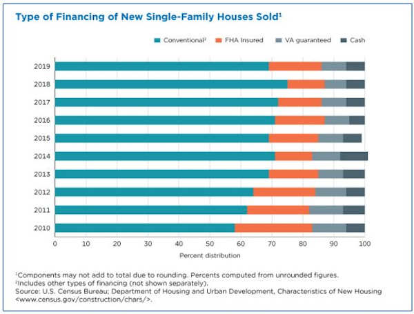
In 2019, 69 percent of new single-family houses sold were purchased using conventional financing – and other types of financing excluding Federal Housing Administration, or FHA, Veteran’s Administration, VA, or cash purchases – up from 58 percent in 2010.
Conventional financing, the primary way new home buyers paid for their purchases, is a mortgage loan not guaranteed by any government agency, such as the VA or FHA.
Features of new homes
Of all the 903,000 new single-family homes completed in 2019:
– 849,000 (or 94%) had air-conditioning.
– 102,000 (11%) had two or fewer bedrooms and 386,000 (43%) had four or more bedrooms.
32,000 (3%) had one and one-half or fewer bathrooms and 296,000 (33%) had three or more bathrooms.
– 366,000 (41%) had a heat pump. Of these, 352,000 were air-source and 14,000 were ground-source.
– 814,000 (90%) were framed in wood and 86,000 (10%) were framed using concrete.
– 296,000 (33%) had a patio and a porch, while 71,000 (8%) had no outdoor features.
– 549,000 (61%) had no fireplace.
In 2019, 683,000 new single-family homes were sold, up 111% from 2010.
A virtual tour of America’s new homes
A fun and easy way to get more details on new single-family homes is through this infographic.
Simply hover for a quick fact on completed or sold homes and click on the legend to go to the tables with the information.
Multifamily housing
The Characteristics of New Housing report also provides information on multifamily housing.
Multifamily housing is defined as residential buildings containing units built one on top of another and those built side-by-side without a ground-to-roof wall and/or common facilities, such as attic, basement, heating system and plumbing.
There were 352,000 new multifamily units completed in the United States in 2019, compared to 155,000 in 2010. The numbers include units for sale as condominiums or cooperatives.
What new multifamily units look like:
– 149,000 (42%) had one bedroom and 40,000 (11%) had three or more bedrooms.
– 349,000 (99%) were conventional apartments and 3,000 (1%) were townhouses.
– 203,000 (58%) were in buildings with four or more floors.
– 304,000 (86%) had individual laundry facilities and 29,000 (8%) had shared laundry facilities.
– 251,000 (71%) were in buildings framed in wood and 33,000 (9%) were in steel-framed buildings.
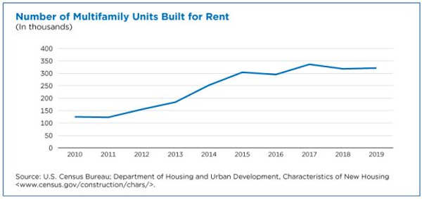
There were 321,000 multifamily units built for rent, a 157% jump from 2010.
Note: Differences between estimates may be attributed to sampling or nonsampling error, rather than to differences in underlying economic conditions. Caution should be used in drawing conclusions from the estimates and comparisons shown. Additional information on the survey methodology, including sampling error (e.g., standard errors and relative standard errors) and nonsampling error, is available at www.census.gov/construction/nrc/how_the_data_are_collected/soc.html.
Philip Thompson is a special projects and outreach coordinator in the Census Bureau’s Economic Management Division.
- Details
- Written by: Morgan Foy and Laura Counts
Despite this success, the debate rages on over whether the costs to industry of further pollution reductions are too high – most recently, the Trump administration declined to tighten soot rules.
After five decades, has the CAA accomplished its mission?
Not even close, say two economists at the University of California, Berkeley who found a novel way to measure the compliance costs for industry by analyzing pollution offset markets.
In a newly released working paper, they concluded that on average, the benefits of additional air pollution regulation exceed the costs by 10 to one.
“We looked at many different cities, states, pollutants and years, and found that in nearly all circumstances, regulation is currently too lenient, rather than too strict,” said Reed Walker, an associate professor at Berkeley’s Haas School of Business. “In other words, there are enormous social benefits to improving air quality just a little bit more when compared to the compliance costs for firms.”
As economists, Walker and co-author Joseph S. Shapiro, an associate professor with UC Berkeley’s Department of Agricultural & Resource Economics, wanted to understand whether the CAA had reached the point of diminishing returns.
“Some of this debate stems from the remarkable improvements we’ve seen in air quality over the past 50 years,” Shapiro said. “Most economists would believe that tightening regulation further becomes incrementally more expensive for firms, which begs the question of whether an additional unit of pollution reduction is ‘worth’ the health and other benefits to society.”
Quantifying costs versus benefits
Estimates of the societal benefits of pollution abatement exist – for instance, research showed that 5 percent of premature mortality is from air pollution – but it’s been far more challenging to measure the true costs to producers.
Walker and Shapiro found a way to do this through a CAA provision that capped pollution levels in the counties with the dirtiest air.
When a manufacturer wants to open a new plant that would raise pollution above existing levels, it must either adopt cleaner technology or pay an existing plant to reduce its emissions in order to stay under the cap. These transactions – known as offsets – have led to the creation of over 500 pollution offset markets across several metro areas.
Offset prices are closely tied to the costs of additional pollution reductions. They can run into the millions of dollars, so a company only buys offsets when the cost of reducing its own pollution is even higher.
That gave the researchers a way to estimate the incremental costs of pollution abatement in different cities. They assembled data on 100 offset markets in 16 states. Next, they used previous estimates of the marginal benefits of pollution reduction to assess whether the benefits of additional reductions outweigh the costs.
“We compared the incremental costs of removing one ton of pollution emissions to the incremental benefits to society of reducing the same one ton of emissions,” Shapiro said.
For example, they estimated that an existing firm in the San Francisco Bay Area would receive almost $1,500 in offset value from lowering its nitrogen oxides emissions by one ton. However, those decreased emissions are worth over $50,000 in societal benefits, due to factors such as reduced premature mortality. This led them to conclude that on average, the benefits of additional pollution regulation are about ten times the marginal costs.
This was true in every market they looked at save Houston, where they determined that regulation was too stringent on volatile organic compound emissions. The result has been marginal costs for industry that are twice as large as the estimated marginal benefits.
The researchers’ new method of calculating pollution abatement costs has led to estimates that are dramatically different than traditional estimates from the Environmental Protection Agency, possibly because EPA estimates did not account for all the economic costs that firms face. Yet even taking into account their finding that abatement costs have increased by about 6 percent to 9 percent annually over the past couple of decades, the benefits of these regulations still greatly outweigh the costs, the researchers said.
“We should always think carefully ‘on the margin’ to understand whether additional improvements in air quality are worth it,” Walker said. “In the vast majority of cities in the United States today, the answer is yes.”
Though it was not a focus of the paper, Walker and Shapiro looked at how CAA regulations could be improved. They suggested that getting rid of the current offset markets—where polluters pay for the quantity of pollution they produce—in favor of a pollution tax could be a more efficient way to improve air quality.
Morgan Foy and Laura Counts write for Berkeley’s Haas School of Business.
- Details
- Written by: Kathleen Scavone
LAKE COUNTY, Calif. – The science of geology presents itself to us daily via Lake County's contrasting landforms of mountains, valleys, streams and lakes.
As you drive south between Hidden Valley and Middletown great tracts of serpentinite, our State Rock lay exposed.
Middletown's Rabbit Hill offers stunning geologic features in its boulders and rock outcrops where serpentinite and a rock made up of microcrystalline quartz known as chert are exposed.
Serpentinite comes in an array of colors from shiny green to tans and browns. If you've driven through the Lake 29 Expressway project, which is, as reported on Aug. 6, 2020, in this publication, "The largest highway project in the county in 50 years," you may have marveled at the geologic features being unearthed by monster machines.
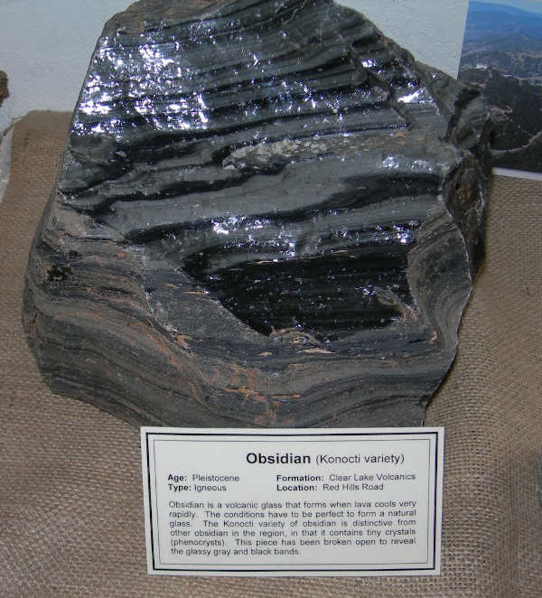
Along the stretch of highway, acres of glistening black obsidian lay exposed, then, farther along the highway red volcanic soils paint another picture of Earth's bold geology, while next along the panoramic highway brilliant white soils are in evidence.
The white features that lay exposed are Pozzolans and Dacite, which are also volcanic in origin and sometimes occur in the centers of old volcanoes.
The volcanic Pozzolans and Dacite are the materials being mined at the big white mountain at Kelseyville's S-Bar-S Quarry.
Since our own volcano, Mount Konocti, is nearby we don't have to look far to find the origins of all of these volcanic materials. But Mount Konocti is but one relatively small volcanic feature in the grand scheme.
Spread around Lake County and its environs are numerous hot springs, along with the Geysers Geothermal Field in the Mayacamas Mountains.
The Geysers' boundaries are the Collayomi and Mercuryville Faults. All of this geothermal activity is due, scientists say, to a large magma body beneath the surface.
The activity from Earth's plates and the continuous changes it incurs happens all along the California coast, with many volcanic fields tied in.
Our own volcanic field is called the Clear Lake Volcanics, and includes the Geysers and Cobb Mountain areas extending down to Lake Berryessa, but not Mount Saint Helena.
The Clear Lake Volcanics is at the top of the chain of volcanic fields. The various volcanic fields that are active over time eventually go extinct. Our Clear Lake Volcanics is still considered active.
Now we can reflect upon our Geology 101 courses of our pasts and remind ourselves that plate tectonics is a large force in our landscape since Earth's crust is made up of moving plates, with each plate moving in varying directions at any given time.
In the Jurassic Period, around 135 million years ago all of the west coast of our continent up to the Sierra Nevada foothills – and that includes Lake County – was submerged beneath the ocean. Geologists tell us that if you look carefully, possibly in a chunk of chert rock from a nearby creek, you may find shell fossils.
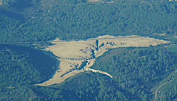
Also seen from Highway 29, between Lower Lake and Kelseyville in Manning Flat, is a large channel that runs throughout the flat where a sign once stated it was "Guy's Fault."
Geologist Dean Enderlin tells the story behind this geologic feature: “The bottom of Thurston Lake is considerably higher in elevation than Clear Lake level, so the two aren't directly connected. Seasonal runoff into Thurston Lake does recharge groundwater, however, which eventually enters Clear Lake as springs in the vicinity of Jago Bay. The water in Thurston Lake is remarkably murky (turbid), because it is fed by clayey runoff from Manning Flat on the ridge to the southwest. This is a man-made effect. Manning Flat was originally a valley with no natural outlet (called a closed basin). Water would have originally accumulated in the basin as seasonal lakes (vernal pools). In an effort to drain the valley, landowners attempted (and eventually succeeded) in cutting a channel through the ridge that separates Manning Flat from the Thurston Lake watershed. Since then, the fine-grained sediments in the Manning Flat basin have eroded rapidly, creating a deeply incised channel that is actively cutting through the soils in the flat and is threatening State Highway 29. As a prank, the channel was once posted with a sign, reading "Guy's Fault," but the channel has nothing to do with faulting. It is purely erosional, but its path across the flat may have followed portions of old roadways and a race track that was once used there."
Our county is full of geologic wonders that await discovery. According to Lake County Marketing's website, www.lakecounty.com , other rocks and minerals that can be found here include, "An abundance of obsidian, onyx, agate, jasper, chert, quartz, travertine, jade, petrified wood and clamshell fossils – many of which are the result of the Clear Lake Volcanic Field. "
When the world opens once again after the pandemic, they invite you to “visit the Lake County Historic Courthouse Museum, where you’ll see a 94-carat faceted Lake County Diamond!"
Kathleen Scavone, M.A., is a retired educator, potter, freelance writer and author of “Anderson Marsh State Historic Park: A Walking History, Prehistory, Flora, and Fauna Tour of a California State Park” and “Native Americans of Lake County.”