 How to resolve AdBlock issue?
News
- Details
- Written by: NATIONAL AERONAUTICS AND SPACE ADMINISTRATION

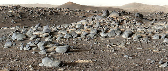
Scientists got a surprise when NASA’s Perseverance Mars rover began examining rocks on the floor of Jezero Crater in spring of 2021: Because the crater held a lake billions of years ago, they had expected to find sedimentary rock, which would have formed when sand and mud settled in a once-watery environment. Instead, they discovered the floor was made of two types of igneous rock – one that formed deep underground from magma, the other from volcanic activity at the surface.
The findings are described in four new papers published Thursday, Aug. 25. In Science, one offers an overview of Perseverance’s exploration of the crater floor before it arrived at Jezero’s ancient river delta in April 2022; a second study in the same journal details distinctive rocks that appear to have formed from a thick body of magma.
The other two papers, published in Science Advances, detail the unique ways that Perseverance’s rock-vaporizing laser and ground-penetrating radar established that igneous rocks cover the crater floor.
Rock of ages
Igneous rocks are excellent timekeepers: Crystals within them record details about the precise moment they formed.
“One great value of the igneous rocks we collected is that they will tell us about when the lake was present in Jezero. We know it was there more recently than the igneous crater floor rocks formed,” said Ken Farley of Caltech, Perseverance’s project scientist and the lead author of the first of the new Science papers. “This will address some major questions: When was Mars’ climate conducive to lakes and rivers on the planet’s surface, and when did it change to the very cold and dry conditions we see today?”
Perseverance took this close-up of a rock target nicknamed “Foux” using its WATSON camera on July 11, 2021, the 139th Martian day, or sol, of the mission. The area within the camera is roughly 1.4 by 1 inches (3.5 centimeters by 2.6 centimeters).
However, because of how it forms, igneous rock isn’t ideal for preserving the potential signs of ancient microscopic life Perseverance is searching for. In contrast, determining the age of sedimentary rock can be challenging, particularly when it contains rock fragments that formed at different times before the rock sediment was deposited.
But sedimentary rock often forms in watery environments suitable for life and is better at preserving ancient signs of life.
That’s why the sediment-rich river delta Perseverance has been exploring since April 2022 has been so tantalizing to scientists.
The rover has begun drilling and collecting core samples of sedimentary rocks there so that the Mars Sample Return campaign could potentially return them to Earth to be studied by powerful lab equipment too large to bring to Mars.

Mysterious magma-formed rocks
A second paper published in Science solves a longstanding mystery on Mars. Years ago, Mars orbiters spotted a rock formation filled with the mineral olivine.
Measuring roughly 27,000 square miles (70,000 square kilometers) – nearly the size of South Carolina – this formation extends from the inside edge of Jezero Crater into the surrounding region.
Scientists have offered various theories why olivine is so plentiful over such a large area of the surface, including meteorite impacts, volcanic eruptions, and sedimentary processes. Another theory is that the olivine formed deep underground from slowly cooling magma – molten rock – before being exposed over time by erosion.
Yang Liu of NASA’s Jet Propulsion Laboratory in Southern California and her co-authors have determined that last explanation is the most likely. Perseverance abraded a rock to reveal its composition; studying the exposed patch, the scientists homed in on the olivine’s large grain size, along with the rock’s chemistry and texture.
Using Perseverance’s Planetary Instrument for X-ray Lithochemistry, or PIXL, they determined the olivine grains in the area measure 1 to 3 millimeters – much larger than would be expected for olivine that formed in rapidly cooling lava at the planet’s surface.
“This large crystal size and its uniform composition in a specific rock texture require a very slow-cooling environment,” Liu said. “So, most likely, this magma in Jezero wasn’t erupting on the surface.”
Unique science tools
The two Science Advances papers detail the findings of science instruments that helped establish that igneous rocks cover the crater floor.
The instruments include Perseverance’s SuperCam laser and a ground-penetrating radar called RIMFAX (Radar Imager for Mars’ Subsurface Experiment).
SuperCam is equipped with rock-vaporizing laser that can zap a target as small as a pencil tip from up to 20 feet (7 meters) away. It studies the resulting vapor using a visible-light spectrometer to determine a rock’s chemical composition.
SuperCam zapped 1,450 points during Perseverance’s first 10 months on Mars, helping scientists arrive at their conclusion about igneous rocks on the crater floor.
In addition, SuperCam used near-infrared light – it’s the first instrument on Mars with that capability – to find that water altered minerals in the crater floor rocks. However, the alterations weren’t pervasive throughout the crater floor, according to the combination of laser and infrared observations.
“SuperCam’s data suggests that either these rock layers were isolated from Jezero’s lake water or that the lake existed for a limited duration,” said Roger Wiens, SuperCam’s principal investigator at Purdue University and Los Alamos National Laboratory.
RIMFAX marks another first: Mars orbiters carry ground-penetrating radars, but no spacecraft on the surface of Mars have before Perseverance. Being on the surface, RIMFAX can provide unparalleled detail, and surveyed the crater floor as deep as 50 feet (15 meters).
Its high-resolution “radargrams” show rock layers unexpectedly inclined up to 15 degrees underground. Understanding how these rock layers are ordered can help scientists build a timeline of Jezero Crater’s formation.
“As the first such instrument to operate on the surface of Mars, RIMFAX has demonstrated the potential value of a ground-penetrating radar as a tool for subsurface exploration,” said Svein-Erik Hamran, RIMFAX’s principal investigator at the University of Oslo in Norway.
The science team is excited by what they’ve found so far, but they’re even more excited about the science that lies ahead.
More about the mission
A key objective for Perseverance’s mission on Mars is astrobiology, including the search for signs of ancient microbial life.
The rover will characterize the planet’s geology and past climate, pave the way for human exploration of the Red Planet, and be the first mission to collect and cache Martian rock and regolith (broken rock and dust).
Subsequent NASA missions, in cooperation with ESA (European Space Agency), would send spacecraft to Mars to collect these sealed samples from the surface and return them to Earth for in-depth analysis.
The Mars 2020 Perseverance mission is part of NASA’s Moon to Mars exploration approach, which includes Artemis missions to the Moon that will help prepare for human exploration of the Red Planet.
JPL, which is managed for NASA by Caltech in Pasadena, California, built and manages operations of the Perseverance rover.
For more about Perseverance visit http://mars.nasa.gov/mars2020/.
- Details
- Written by: Elizabeth Larson

LAKE COUNTY, Calif. — An Upper Lake man who authorities said assaulted a woman earlier this month is in custody.
Arturo Pedro Gutierrez, 62, turned himself in to authorities in Mendocino County, Lauren Berlinn, spokesperson for the Lake County Sheriff’s Office, told Lake County News on Friday afternoon.
The sheriff’s office had been seeking to take Gutierrez, a registered sex offender, into custody for the Aug. 18 assault.
Earlier this week, a $500,000 warrant was for Gutierrez’s arrest, as Lake County News has reported.
Berlinn said Gutierrez will be transported to the Hill Road Correctional Facility in Lakeport.
Email Elizabeth Larson at
- Details
- Written by: Elizabeth Larson
LAKE COUNTY, Calif. — The Board of Supervisors on Tuesday approved an agreement between the county and Pacific Gas and Electric Co. to use Lucerne Harbor Park as a community resource center during public safety power shutoffs.
Public Services Director Lars Ewing presented the agreement to the board.
His written report explained that PG&E contacted Public Services and the Lake County Office of Emergency Services last month with a proposal for the agreement to use the park when public safety power shutoffs occur in the Northshore area.
Ewing’s report said other county facilities have been used by PG&E for resource centers in the past.
The center at the park would be in a tent powered by generators, with tables and seating, offering snacks, water, electronic device charging and information on the outages, and would operate from 8 a.m. to 10 p.m. daily during the shutoffs, Ewing reported.
He said PG&E would staff and secure the center around the clock.
The agreement included a map of the park, showing that it would take up 18 parking spaces on the side of the park next to the beach. Ewing estimated the center would use up to 75% of the park, but the rest of the park would be available to the public.
The county would receive $200 a day for the use of the park. Ewing said the shutoffs would take place for a period of between two and 10 days.
PG&E representative Melinda Rivera told the board the company previously had another location in Lucerne in contract for a community resource center but they are not able to renew it. That led them to reach out to the county to look for a new option.
It was explained later in the discussion by another PG&E staffer, Rich Noonan, that the previous contract in Lucerne had been for the Lucerne Hotel, under the management of New Paradigm College. Something happened and the college decided that it did not want to continue with the contract.
Noonan said that left them with the need to find another site, and one that is Americans with Disabilities Act-compliant.
“In Lucerne, the park was our best and only option,” he said.
Supervisor Bruno Sabatier asked during the discussion if the payment for the park use would go into the general fund or into a fund to be used specifically for Lucerne Harbor Park. Ewing said it would be the general fund.
Sabatier said he would like to have a different conversation at some point about allocating money from the rental of parks back to the specific parks in order to address wear and tear.
Ewing said they could earmark the funds from Lucerne Harbor Park’s use as a community resource center to go back to that specific park.
The agreement requires PG&E to give the county eight hours of advance notice before activating the community resource center. If the county can’t do it, they need to give PG&E four hours advance notice.
Ewing was concerned that there may be vehicles parked in the park that they can’t get rid of in time, and he didn’t want the county to be responsible for clearing the park.
That was an apparent reference to recent issues at the park with RVs parked in the same spots for days on end.
Ewing said the park is very rarely packed to the point of not being able to find space. He added that he didn’t have an answer to the problem but wanted to make sure to discuss it with the supervisors.
County Counsel Anita Grant said there are other things the county can do to minimize risk, like signage at the park.
Sheriff Brian Martin said he supported the agreement, explaining that his agency had asked PG&E to be more proactive in mitigating impacts. He said it’s a good partnership.
Sabatier moved to approve the agreement, with Supervisor Moke Simon seconding and the board approving it 4-0.
At another county-owned property, the previous site of the Lucerne Clubhouse at 6325 East Highway 20, PG&E finished construction last year of a microgrid, or sectionalizing device meant to break up the grid into smaller pieces and narrow the scope of PSPS events so fewer customers are impacted.
The board approved an agreement to locate that microgrid there in November 2020.
Email Elizabeth Larson at
PGE CRC Agreement Lucerne Habor Park (Signed) by LakeCoNews on Scribd
- Details
- Written by: LAKE COUNTY NEWS REPORTS
In February, Assemblyman James C. Ramos (D-Highland), the first California Native American elected to the state legislature, and Assemblywoman Cristina Garcia (D-Bell Gardens), chair of the California Legislative Women’s Caucus, along with 13 co-authors introduced AB 2022.
The Legislature approved the Bill on a 72-0-0 vote, Ramos’ office reported.
The bill now heads to Gov. Gavin Newsom’s desk for signing.
It bans the use of the S-word and establishes a process for renaming locations with that derogatory term in their titles.
The word is an idiom that came into use during the westward expansion of America, and it is not a tribal word.
For decades, Native Americans have argued against the designation’s use because behind that expression is the disparagement of Native women that contributes to the crisis of missing and murdered people in our community,” Ramos stated.
Ramos reported that more than 100 places in California contain the S-word.
The United States Department of the Interior has ordered the term “erased from the National landscape and forever replaced” on the almost 700 sites using the name on federal lands.
Montana, Oregon, Maine and Minnesota have already banned the word’s use.
AB 2022 requires every state agency, local governing body or political subdivisions to identify all geographic sites, public lands, waters, and structures under its jurisdiction containing the S-word.
These bodies shall file a report identifying those names with the California Advisory Committee of Geographic Names.
The advisory committee will establish a procedure to elicit input and rename locations that have been identified.
In selecting replacement names, local governments, state agencies, and shall solicit input from tribes maintained on the California Native American Heritage Commission list and prioritize their input, as well as the input of appropriate local communities and members of the public.
The proposal defines a geographic feature as any location or publicly owned structure in the state such as navigable water, parks, local roads, bridges and publicly owned buildings.
A place is defined in the proposal as a natural geographic feature or street, alley, or other road within the jurisdiction of the state or political subdivision of the state.