 How to resolve AdBlock issue?
News
- Details
- Written by: David Jachowski, Clemson University
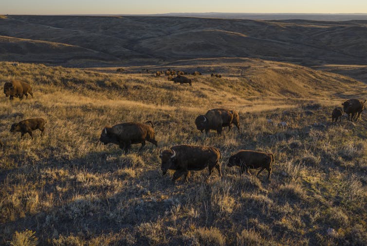
Driving north on state Highway 66 through the Fort Belknap Indian Reservation in central Montana, it’s easy to miss a small herd of bison lounging just off the road behind an 8-foot fence. Each winter, heavy snows drive bison out of Wyoming’s Yellowstone National Park – the only place in the U.S. where they have lived continuously since prehistoric times – and into Montana, where they are either killed or shipped off to tribal lands to avoid conflict with cattle ranchers.
In the winter of 2022-2023 alone, over 1,500 bison have been “removed,” about 25% of Yellowstone’s entire population. The bison at Fort Belknap are refugees that have been trucked 300 miles to the reservation from past Yellowstone winter culls.
Although bison are the U.S. national mammal, they exist in small and fragmented populations across the West. The federal government is working to restore healthy wild bison populations, relying heavily on sovereign tribal lands to house them.
Indeed, tribal lands are the great wildlife refuges of the prairie. Fort Belknap is the only place in Montana where bison, critically endangered black-footed ferrets and swift foxes, which occupy about 40% of their historic range, all have been restored.

But Indigenous communities can’t and shouldn’t be solely responsible for restoring wildlife. As an ecologist who studies prairie ecosystems, I believe that conserving grassland wildlife in the U.S. Great Plains and elsewhere will require public and private organizations to work together to create new, larger protected areas where these species can roam.
Rethinking how protected areas are made
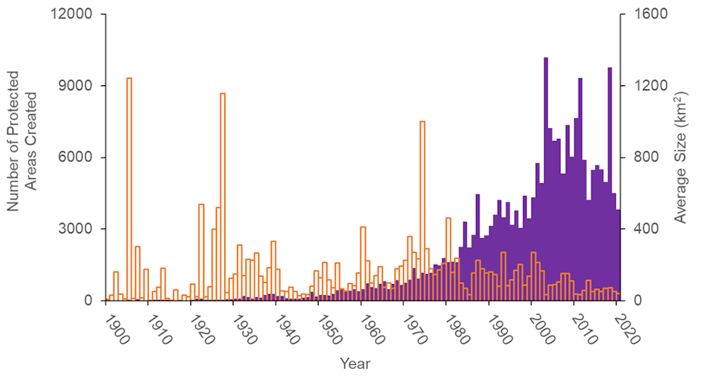
At a global scale, conservationists have done a remarkable job of conserving land, creating over 6,000 terrestrial protected areas per year over the past decade. But small has become the norm. The average size of newly created protected areas over that time frame is 23 square miles (60 square kilometers), down from 119 square miles (308 square kilometers) during the 1970s.
Creating large new protected areas is hard. As the human population grows, fewer and fewer places are available to be set aside for conservation. But conserving large areas is important because it makes it possible to restore critical ecological processes like migration and to sustain populations of endangered wildlife like bison that need room to roam.
Creating an extensive protected area in the Great Plains is particularly difficult because this area was largely passed over when the U.S. national park system was created. But it’s becoming clear that it is possible to create large protected areas through nontraditional methods.
Consider American Prairie, a nonprofit that is working to stitch together public and tribal lands to create a Connecticut-sized protected area for grassland wildlife in Montana. Since 2004, American Prairie has made 37 land purchases and amassed a habitat base of 460,000 acres (about 720 square miles, or 1,865 square kilometers).
Similarly, in Australia, nonprofits are making staggering progress in conserving land while government agencies struggle with funding cuts and bureaucratic hurdles. Today, Australia is second only to the U.S. in its amount of land managed privately for conservation.
Big ideas make room for smaller actions
Having worked to conserve wildlife in this region for over 20 years, I have seen firsthand that by setting a sweeping goal of connecting 3.2 million acres (5,000 square miles, or 13,000 square kilometers), American Prairie has reframed the scale at which conservation success is measured in the Great Plains. By raising the bar for land protection, they have made other conservation organizations seem more moderate and created new opportunities for those groups.
One leading beneficiary is The Nature Conservancy, which owns the 60,000-acre Matador Ranch within the American Prairie focal area. When the conservancy first purchased the property, local ranchers were skeptical. But that skepticism has turned to support because the conservancy isn’t trying to create a protected area.
Instead, it uses the ranch as a grassbank – a place where ranchers can graze cattle at a low cost, and in return, pledge to follow wildlife-friendly practices on their own land, such as altering fences to allow migratory pronghorn to slip underneath. Via the grassbank, ranchers are now using these wildlife conservation techniques on an additional 240,000 acres of private property.
Other moderate conservation organizations are also working with ranchers. For example, this year the Bezos Earth Fund has contributed heavily to the National Fish and Wildlife Foundation’s annual grants program, helping to make a record $US16 million available to reward ranchers for taking wildlife-friendly actions.
A collective model for achieving a large-scale protected area in the region has taken shape. American Prairie provides the vision and acts to link large tracts of protected land for restoring wildlife. Other organizations work with surrounding landowners to increase tolerance toward wildlife so those animals can move about more freely.
Instead of aiming to create a single polygon of protected land on a map, this new approach seeks to assemble a large protected area with diverse owners who all benefit from participating. Rather than excluding people, it integrates local communities to achieve large-scale conservation.
A global pathway to 30x30
This Montana example is not unique. In a recent study, colleagues and I found that when conservationists propose creating very large protected areas, they transform conservation discussions and draw in other organizations that together can achieve big results.
Many recent successes started with a single actor leading the charge. Perhaps the most notable example is the recently created Cook Islands Marine Park, also known as Marae Moana, which covers 735,000 square miles (1.9 million square kilometers) in the South Pacific. The reserve’s origin can be traced back to Kevin Iro, an outspoken former professional rugby player and member of the islands’ tourism board.
While some individual conservation organizations have found that this strategy works, global, national and local policymakers are not setting comparable large-scale targets as they discuss how to meet an ambitious worldwide goal of protecting 30% of the planet for wildlife by 2030. The 30x30 target was adopted by 190 countries at an international conference in 2022 on saving biodiversity.
Critics argue that large protected areas are too complicated to create and too expensive to maintain, or that they exclude local communities. However, new models show that there is a sustainable and inclusive way to move forward.
In my view, 30x30 policymakers should act boldly and include large protected area targets in current policies. Past experience shows that failing to do so will mean that future protected areas become smaller and smaller and ultimately fail to address Earth’s biodiversity crisis.![]()
David Jachowski, Associate Professor of Wildlife Ecology, Clemson University
This article is republished from The Conversation under a Creative Commons license. Read the original article.
- Details
- Written by: Sally Younger
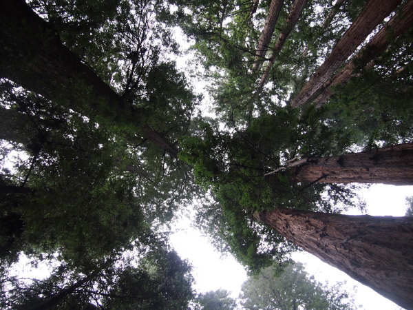
Century-old sugar maples in Wisconsin. Five-hundred-year-old cedars in Oklahoma. Fifty-foot-wide oaks in Georgia. These trees grace our nation’s old-growth forests, and scientists say they hold unexplored mysteries from their roots to their rings.
In an effort to steward these resources, on Earth Day 2022 the Biden Administration called upon the Department of Agriculture and the Bureau of Land Management to define and map such forests on federal lands.
A year later, that work has yielded a first-ever national inventory of mature and old-growth forests — broadly characterized as forests at an advanced stage of development. And with some help from NASA, the public will soon be able view some of these forests like never before.
The nation’s old-growth forests encompass different tree species in different regions, from towering redwoods and 5,000-year-old bristlecone pines to diminutive pinyon junipers whose age and grandeur are less immediately obvious.
For decades the Forest Service has studied such trees in hundreds of thousands of plots across the country, but the agency has never issued a formal accounting until now.
To identify and define such forests, the team analyzed decades of field-gathered data from a wide variety of forest types and ecological zones, while also collecting public input in the process.
America’s forests help absorb more than 10% of our annual greenhouse gas emissions. While younger vegetation accumulates carbon more rapidly, old-growth forests contain more biomass overall and store more carbon.
Not only are these ecosystems essential to the country’s clean air and water, they hold special significance to Tribal Nations, they sustain local economies, and they conserve biodiversity.
Complementing the Forest Service’s boots-on-the-ground research, some NASA-funded scientists are using a space-based instrument called Global Ecosystem Dynamics Investigation, or GEDI, to provide a detailed picture of these forests.
From its perch on the International Space Station, GEDI’s laser imager (lidar) is able to peer through dense canopies to observe nearly all of Earth’s temperate and tropical forests.
By recording the way the laser pulses are reflected by the ground and by plant material (stems, branches, and leaves) at different heights, GEDI makes detailed measurements of the three-dimensional structure of the planet’s forests and fields. It can even estimate the weight, height, and vertical structure of trees.
“The partnership with NASA will help us do analyses we have not been able to do in the past,” said Jamie Barbour, who leads the old-growth initiative for the Forest Service. “From space, we’ll be able to drill down and learn about so many more places.”
Old trees, enduring threats
Substantial portions of U.S. old-growth forests have been lost in recent centuries, researchers have reported.
Logging greatly altered the forests that Europeans found when they came to North America, while invasive insects and diseases have more recently ravaged important tree species.
Surviving forests also face a new generation of threats, including climate change-fueled wildfires, heavy rainfall events, and chronic temperature and drought stress.
Species like the American beech, eastern hemlock, American elm, and ash have been vastly diminished, said Neil Pederson, an ecologist and tree-ring specialist (dendrochronologist) at Harvard University.
He said that conserving what’s left is critical if we’re going to continue to make fundamental discoveries about trees, such as how long they live and why, and what they can tell us about Earth’s past.
“This project is challenging us to really take a step back and think about why these older forests matter to us and how we can be more proactive about addressing the issues they face,” said Marin Palmer, technical team lead for the Forest Service. “We sometimes imagine these forests have never been touched by humans, but we have to look further back in history and understand that indigenous people were intentionally managing their forests for millennia. When we think about the threat climate change poses, it becomes a larger conversation about the need to be active stewards in our landscapes and ecosystems.”
Tree rings are a data record of Earth’s climate, and they teach us things that we don’t typically learn about in textbooks, Pederson said. “In the United States, our best meteorological records are only about 130 years old,” he said. "Living and fossil trees allow us to reconstruct temperature and precipitation history across hundreds or thousands of years, helping us better understand drought and wet periods.”
The Forest Service will continue to work alongside partners like NASA to gather aerial and satellite imagery and map mature and old growth at finer scales. Such data can also help the Forest Service create a long-term monitoring system. Meanwhile, a team of interagency experts will analyze and assess threats and risks to these areas.
GEDI collected four years of forest observations around the world, before recently entering hibernation on the International Space Station. Extension of the GEDI mission is currently under discussion, and if the extension is approved, it is expected that monitoring of mature and old-growth forests will resume when it returns to service within two years.
“It’s a really a revolutionary time we're living in right now with all these different sets of remote sensing data that are already in space or going into space,” said Ralph Dubayah, a professor at the University of Maryland and principal investigator of the GEDI mission. “This is radically changing how we go forward in these kinds of endeavors.”
Sally Younger is a member of the Earth Science News Team, based at NASA's Jet Propulsion Laboratory in Pasadena, Calif.
- Details
- Written by: LAKE COUNTY NEWS REPORTS
The board and staff of Mother-Wise invite the community to invite them for their “Mother’s Day Bingo” event on Friday, May 12.
The event will take place from 5 to 8 p.m. in the Little Theater at the Lake County Fairgrounds, 401 Martin St. in Lakeport.
It will be a fun night of bingo, prizes, a silent auction, delicious tacos from Terped Out Kitchen, beer and wine for purchase, and the unveiling of Mother-Wise’s new logo.
Mother-Wise provides judgment-free assistance and peer group support to Lake County women experiencing depression, anxiety and bereavement.
Organizers say their critical work is needed now more than ever.
The goal for the May 12 fundraiser is to send three Mother-Wise staff members to a certification training in perinatal mood and anxiety disorders.
Tickets are $45 per person and can be purchased here.
For more information or to find out how to support Mother-Wise, visit www.mother-wise.org or call 707-349-1210.
- Details
- Written by: LAKE COUNTY NEWS REPORTS
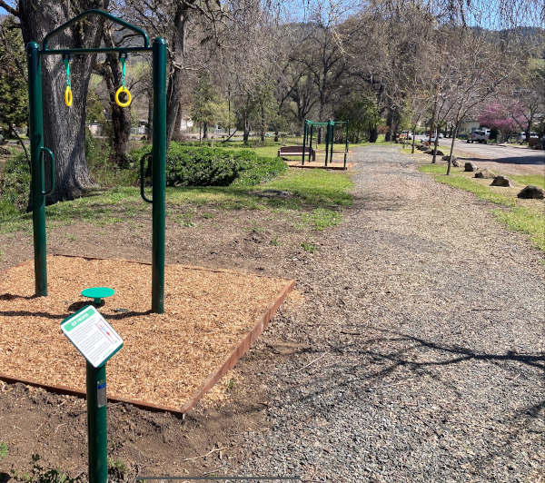
LUCERNE, Calif. — The Lake County Parks and Recreation Division has constructed an outdoor trail and installed multiple fitness stations at Lucerne Creek Park.
Located along the shores of Lucerne Creek, it offers an expanded recreational and fitness opportunity for Northshore residents.
Regular physical activity is a cornerstone of a healthy, well-balanced life. Outdoor adult fitness facilities are reported to be vital to realizing community health and wellness goals.
Additional facilities will soon be developed at Hammond Park in Nice and Kelseyville Community Park.
“We are working to make physical activity and exercise more available, accessible and enjoyable for all Lake County residents,” said Lake County’s Public Services Director Lars Ewing. “Our new Lucerne Creek Park facility and others already in place are a great start. More amenities are planned for the future, and we are grateful to all of the members of the public who have recently engaged in visioning activities.”
“We all know physical activity is great for overall health, brain health and reducing risk factors for disease,” said Jonathan Portney, Lake County’s Health Services director. “And research shows being outdoors may have emotional and cognitive benefits.”
For more information, contact the Public Services Department at 707-262-1618.