How to resolve AdBlock issue?
News
LAKE COUNTY, Calif. — State officials on Saturday evening gave an update on the powerful storm conditions moving across California, which in some areas have led to flooding.
California Department of Water Resources staff said a series of big storms will be hitting California this week, bringing not just more water but high winds.
State Climatologist Dr. Michael Anderson said a string of storms are underway. The first began on Dec. 27, and they are expected to continue until Jan. 19.
“We want to stay on this,” he said of the state’s effort to monitor the situation.
The next storm in the series was expected to come on shore on Saturday night, Anderson said.
That is to be followed by a second storm early in the week that’s a bigger concern and will have more impact, followed by storms three, four and five.
Precipitation maps developed by forecasters showed large amounts of rainfall statewide.
“We see some pretty astounding numbers here,” from the North Coast to San Diego, Anderson said.
He said the coming six days could see the state getting just as much rain as its already been through due to the unrelenting storms.
Anderson said a partnership of state and federal agencies, the Atmospheric River Recon, has several planes flying the storms, with that data being placed into National Weather Service forecast models.
The result, said Anderson, is an improved precipitation model that is helping with forecasting the coming storms.
Jeremy Arrich, manager of DWR’s Division of Flood Management, said the state’s Flood Operations Center has been activated since Jan. 3.
He said the center serves as a hub to gather and share information that’s used to support locally led flood emergency response efforts across the state.
The center can also supply direct materials, enlist crews and let out construction contracts for placing rock where needed or using other flood fighting methods to mitigate the impacts to levees or other areas.
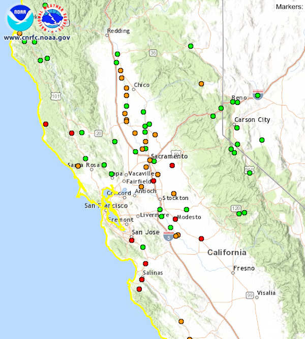
As of Saturday night, he said there were 15 water systems in the state forecasted to exceed flood stage and 30 forecasted to exceed monitor stage.
According to the California Nevada River Forecast Center, the areas approaching flood stage that are closest to Lake County are the Russian River in Hopland and the Russian River in Guerneville.
Arrich said that California’s two largest reservoirs connected to the Sacramento River system, Oroville and Shasta, both have a lot of room in them still, even after the heavy rains of the past few weeks.
“That’s going to be a big relief valve for us in terms of that available storage,” Arrich said.
“DWR expects widespread impacts in small streams and creeks across the state, localized street flooding, low lying areas, areas with poor drainage, and other areas that are prone to flooding like coastal areas, recent wildfire burn scar areas and areas prone to rock or mudslides,” he said.
Californians should pay attention to safety messages from local authorities, heed all signs posted on roadways, and absolutely never attempt to drive through a flooded roadway, Arrich said.
Arrich also urged people to have an evacuation plan and to leave immediately if local authorities direct it.
Over the past week, the Flood Operations Center has been very busy and has coordinated efforts to help deliver materials and equipment to 12 counties, including more than 150,000 sandbags, six flood fight containers, more than 3,000 linear feet of reinforcing muscle wall and deployment of flood fight specialists to various locations, Arrich said.
Materials and equipment also have been positioned at 49 locations statewide and are ready when needed, and specialists have been deployed to support counties and agencies in flood fighting efforts, Arrich said.
Arrich said incident command teams are prepared to be deployed statewide as needed, and they’ve also been reaching out to levee managers and counties and cities to keep them informed of high water conditions, and to coordinate increased levee and flood system patrols.
The Flood Operations Center also is coordinating with the state Office of Emergency Services and emergency officials on the local level, he said.
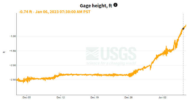
Late Saturday, Clear Lake’s level was at -0.24 feet Rumsey, the special measure for Clear Lake.
With the rainfall, it’s anticipated the lake will soon cross into the plus side.
Email Elizabeth Larson at

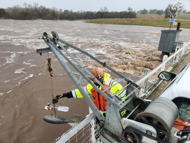
U.S. Geological Survey field crews measured high streamflows this past week throughout California, thirteen of which were record high-flow measurements.
These measurements provide information that protect life, property, and the environment including uses for water supply and management, monitoring floods and droughts, bridge and road design, determination of flood risk and many recreational activities
“Heavy rains and hazardous weather conditions continue in northern California this week,” said Mark Dickman, associate director of data for the USGS California Water Science Center. “Streamflows have been very high, and we expect more over parts of the region the next several days.”
USGS crews made 77 streamflow measurements at 58 streamgages between December 31, 2022 and January 2, 2023, and recorded 13 preliminary record-high streamflow measurements in northern California. To the east of Sacramento, crews captured the highest direct measurement ever recorded at streamgage 11335000 on the Cosumnes River near Michigan Bar, CA — 63,700 cubic feet per second — in over 100 years of record. Additional historic peaks are expected throughout the state this week, as another atmospheric river is likely to occur.
These data are used by the National Weather Service to develop flood forecasts, the U.S. Army Corps of Engineers to manage flood control and local agencies in their flood response activities.
“The SFPUC relies on accurate and real-time hydrology information for our water supply system and watershed land operations, particularly during storm events,” said Tim Ramirez with the San Francisco Public Utilities Commission. “Information regarding reservoir levels, and streams flowing into and from the reservoirs are critical data we use to make operational decisions, and we are grateful for the USGS staff out in the field during these storm events who are an important part of our team.”
There are 458 USGS-operated streamgages in California that measure water levels, streamflow, and rainfall automatically and send data wirelessly, which are accessible from the National Water Dashboard. When flooding occurs, USGS crews make numerous streamflow measurements to verify the data that the USGS provides to federal, state, and local agencies, as well as to the public.
For more than 125 years, the USGS has monitored flow in selected streams and rivers across the United States.
Access current flood and high flow conditions across the country by visiting the USGS National Water Dashboard. Receive instant, customized updates about water conditions in your area via text message or email by signing up for USGS WaterAlert.

Dogs available for adoption this week include mixes of Alaskan malamute, Belgian Malinois, Chihuahua, German shepherd, hound, husky, Labrador retriever, pit bull, Schipperke, shepherd and terrier.
Dogs that are adopted from Lake County Animal Care and Control are either neutered or spayed, microchipped and, if old enough, given a rabies shot and county license before being released to their new owner. License fees do not apply to residents of the cities of Lakeport or Clearlake.
The following dogs at the Lake County Animal Care and Control shelter have been cleared for adoption.
Call Lake County Animal Care and Control at 707-263-0278 or visit the shelter online for information on visiting or adopting.

‘Malachi’
“Malachi” is a 4-year-old male Alaskan malamute with a long black and white coat.
He is in kennel No. 18, ID No. LCAC-A-4434.

Lab-pit bull mix puppy
This female Labrador retriever-pit bull mix puppy has a short black coat with white markings.
She is in kennel No. 2, ID No. LCAC-A-4451.

Male Schipperke
This 3-and-a-half-year-old male Schipperke has a long black coat.
He is in kennel No. 3, ID No. LCAC-A-4453.

Male pit bull
This 3-year-old male pit bull has a short white coat with gray markings.
He is in kennel No. 7, ID No. LCAC-A-4425.

Female German shepherd
This 10-month-old female German shepherd has a black and tan coat.
She is in kennel No. 8, ID No. LCAC-A-4448.

Female Belgian Malinois
This 6-month-old female Belgian Malinois has a short black and tan coat.
She is in kennel No. 10, ID No. LCAC-A-4447.

Male pit bull terrier
This 4-year-old male pit bull terrier has a short brown coat.
He is in kennel No. 11, ID No. LCAC-A-4496.

Female Chihuahua
This 2-year-old female Chihuahua has a short brown coat.
She is in kennel No. 12, ID No. LCAC-A-4469.

Female pit bull terrier
This 1-year-old female pit bull terrier has a short tan and white coat.
She is in kennel No. 14, ID No. LCAC-A-4493.

Male pit bull terrier
This 1-year-old male pit bull terrier has a short black coat.
He is in kennel No. 15, ID No. LCAC-A-4494.

Female terrier
This 2-year-old female terrier has a short tan and white coat.
She is in kennel No. 16, ID No. LCAC-A-4452.

Female hound
This 8-month-old female hound has a fawn coat.
She is in kennel No. 17, ID No. LCAC-A-4386.

Female pit bull terrier
This 1-year-old female pit bull terrier has a short black coat with white markings.
She is in kennel No. 19, ID No. LCAC-A-4461.

‘Tyson’
“Tyson” is a handsome male husky with a red and white coat.
He is in kennel No. 20, ID No. LCAC-A-4344.

Female terrier
This 7-month-old female terrier has a short brown coat.
She is in kennel No. 23, ID No. LCAC-A-4436.

Female pit bull terrier
This 2-year-old female pit bull terrier has a short black and white coat.
She is in kennel No. 24, ID No. LCAC-A-4484.

Male pit bull
This 3-year-old male pit bull has a short black and white coat.
He is in kennel No. 26, ID No. LCAC-A-4445.

Female shepherd
This 3-year-old female shepherd mix has a short tan coat.
She is in kennel No. 27, ID No. LCAC-A-4449.

Female German shepherd
This 1-year-old female German shepherd has a black and tan coat.
She is in kennel No. 30, ID No. LCAC-A-4486.

Male shepherd
This 3-year-old male shepherd has a short black and tan coat.
He is in kennel No. 31, ID No. LCAC-A-4312.

Male terrier
This 1-year-old male terrier has a tan and white coat.
He is in kennel No. 33, ID No. LCAC-A-4470.
Email Elizabeth Larson at
The year 2022 was a tough one for the growing number of people living in food insecurity and energy poverty around the world, and the beginning of 2023 is looking bleak.
Russia’s war on Ukraine, one of the world’s largest grain and fertilizer feedstock suppliers, tightened global food and energy supplies, which in turn helped spur inflation.
Drought, exacerbated in some places by warring groups blocking food aid, pushed parts of the Horn of Africa toward famine. Extreme weather disasters have left trails of destruction with mounting costs on nearly every continent. More countries found themselves in debt distress.
But below the surface of almost weekly bad news, significant changes are underway that have the potential to create a more sustainable world – one in which humanity can tackle climate change, species extinction and food and energy insecurity.
I’ve been involved in international sustainable development for most of my career and now teach climate diplomacy. Here’s how two key systems that drive the world’s economy – energy and finance – are starting to shift toward sustainability and what to watch for in 2023.
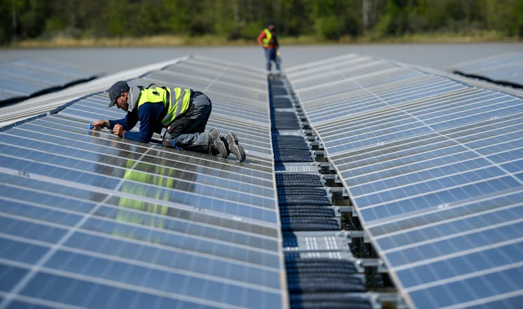
Ramping up renewable energy growth
Russian President Vladimir Putin’s war on Ukraine has reverberated through Europe and spread to other countries that have long been dependent on the region for natural gas. But while oil-producing countries and gas lobbyists are arguing for more drilling, global energy investments reflect a quickening transition to cleaner energy.
Call it the Putin effect – Russia’s war is speeding up the global shift away from fossil fuels.
In December, the International Energy Agency published two important reports that point to the future of renewable energy.
First, the IEA revised its projection of renewable energy growth upward by 30%. It now expects the world to install as much solar and wind power in the next five years as it installed in the past 50 years.
The second report showed that energy use is becoming more efficient globally, with efficiency increasing by about 2% per year. As energy analyst Kingsmill Bond at the energy research group RMI noted, the two reports together suggest that fossil fuel demand may have peaked. While some low-income countries have been eager for deals to tap their fossil fuel resources, the IEA warns that new fossil fuel production risks becoming stranded, or uneconomic, in the next 20 years.
The main obstacles to the exponential growth in renewable energy, IEA points out, are antiquated energy policy frameworks, regulations and subsidies written at a time when energy systems, pricing and utilities were all geared toward fossil fuels.
Look in 2023 for reforms, including countries wrestling with how to permit smart grids and new transmission lines and finding ways to reward consumers for efficiency and clean energy generation.
The year 2023 will also see more focus on developing talent for the clean energy infrastructure build-out. In the U.S., the recently passed Inflation Reduction Act and the Bipartisan Infrastructure Law will pour hundreds of billions of dollars into clean energy and technology. Europe’s REPowerEU commitments will also boost investment. However, concerns about “buy American” rules within the new U.S. climate laws and an EU plan to launch a carbon border adjustment tax are raising fears that nationalism in trade policy could harm the speed of green growth.
Fixing international climate finance
The second system to watch for reform in 2023 is international finance. It’s also crucial to how low-income countries develop their energy systems, build resilience and recover from climate disasters.
Wealthy nations haven’t moved the energy transition forward quickly enough or provided enough support for emerging markets and developing countries to leapfrog inefficient fossil-fueled energy systems. Debt is ballooning in low-income countries, and climate change and disasters like the devastating flooding in Pakistan wipe out growth and add costs.
Barbados Prime Minister Mia Mottley has brought together international financial institutions with think tanks and philanthropists to push for changes.

Countries like Mottley’s have been frustrated that the current international financial system – primarily the International Monetary Fund and the multilateral development banks, including the World Bank – haven’t adapted to the growing climate challenges.
Mottley’s Bridgetown Initiative proposes a new approach. It calls for countries’ vulnerability to be measured by climate impact, and for funds to be made available on that basis, rather than income. It also urges more risk-taking by the development banks to leverage private investment in vulnerable countries, including climate debt swaps.
The Bridgetown Initiative also calls for countries to reflow their IMF Special Drawing Rights – a reserve available to IMF members – into a proposed fund that vulnerable countries could then use to build resilience to climate change. A working group established by the G-20 points out that the “easiest” trillion dollars to access for urgent climate response is that already in the system.
In early 2023, Mottley and French President Emmanuel Macron, with others, will drive a process to examine the possible measures to improve the current system before the annual meetings of the World Bank and the IMF in April, and then at a June summit called by France.
Watch in 2023 to see if this is the year the G-7 and the G-20 rekindle their global economic leadership roles. Their members are the largest owners of the international financial institutions, and also the largest emitters of carbon dioxide on the planet. India will lead the G-20 in 2023, followed by Brazil in 2024. Their leadership will be critical.
Watch small nations’ leadership in 2023
In 2023, expect to see small nations increasingly push for global transformation, led by the V-20 – the finance ministers of the countries most vulnerable to climate change.
In addition to the Bridgetown Initiative, Barbados has suggested a way to pool new funds working off the model of an oil spill damage fund at the International Maritime Organization. In the IMO fund, big oil importers pay in, and the fund pays out in the event of a spill. Barbados supports creating a similar fund to help countries when a climate event costs more than 5% of a country’s GDP.
This model is potentially a way to pool funds from a levy on the windfall profits of energy companies that saw their profits soar in 2022 while billions of people around the world suffered from energy price inflation.
Finally, the breakthrough agreement on biodiversity reached in December 2022 provides more promise for 2023. Countries agreed to conserve 30% of the world’s biodiversity and restore 30% of the world’s degraded lands. The funding – a $30 billion fund by 2030 – remains to be found, but the plan clarifies the task ahead and nature’s place in it. And we can hope 2023 is a year when signs of peace in our war against nature break out.![]()
Rachel Kyte, Dean of the Fletcher School, Tufts University
This article is republished from The Conversation under a Creative Commons license. Read the original article.
What's up for January? The planets have some close encounters, the bright stars of winter, and a chance to catch a comet.
All month after sunset, you can see four planets without the aid of binoculars or a telescope.
You'll find Mars in the east, Jupiter high overhead, and Saturn in the southwest with Venus.
From about Jan. 18 to the 24, watch Venus cross paths with Saturn as the glow of sunset fades. Look for the pair low in the southwest about 45 minutes after the Sun dips below the horizon.
The two planets appear at their closest on Jan. 22, when they'll be only a third of a degree apart on the sky. You'll be able to capture both of them in the same field of view through binoculars or a small telescope.
On Jan. 23, the two planets are still only a degree apart, and will be joined by a slim crescent moon.
And on Jan. 25, looking to the southwest 30 to 45 minutes after sunset, look high above Venus and Saturn to find the Moon only a degree apart from Jupiter, about halfway up the sky.
January nights are filled with bright stars. Looking toward the south or southeast in the first few hours after dark, you'll spy the bright constellations of winter in the Northern Hemisphere: Of course there's Orion the hunter; the big dog constellation Canis Major; and the lesser known little dog, Canis Minor with its bright star Procyon.
Y-shaped Taurus, the bull, includes the bright Hyades and Pleiades star clusters. And just east of Orion, you'll find the bright stars Castor and Pollux, which form the heads of the twins in Gemini.
Make sure you take a moment to appreciate the beauty of the January sky, which more than meets the definition of "star studded," with so much to marvel at.
A recently discovered comet is now passing through the inner solar system and should be visible with a telescope and likely with binoculars.
The comet, which has a mouthful of a name — C/2022 E3, or ZTF — was first sighted in March last year, when it was already inside the orbit of Jupiter.
It makes its closest approach to the Sun on Jan. 12, and then passes its closest to Earth on Feb. 2.
Comets are notoriously unpredictable, but if this one continues its current trend in brightness, it'll be easy to spot with binoculars, and it's just possible it could become visible to the unaided eye under dark skies.
Observers in the Northern Hemisphere will find the comet in the morning sky, as it moves swiftly toward the northwest during January. (It'll become visible in the Southern Hemisphere in early February.)
This comet isn't expected to be quite the spectacle that Comet NEOWISE was back in 2020. But it's still an awesome opportunity to make a personal connection with an icy visitor from the distant outer solar system.
Stay up to date with all of NASA's missions to explore the solar system and beyond at nasa.gov.
Preston Dyches works for NASA's Jet Propulsion Laboratory.
The National Weather Service's Eureka Office is predicting up to 12 inches of additional rain from Saturday through Tuesday for portions of Lake County.
The forecast also predicts strong southerly winds, heavy high elevation snow, and a new widespread flooding threat from heavy rainfall atop of already saturated ground.
The National Weather Service placed all of Lake County under a flood watch from 4 a.m. Saturday, Jan. 7, to 4 p.m. Tuesday, Jan. 10. Forecasters also issued a hazardous weather outlook for Lake County.
Areas including Lakeport and the Northshore are expected to have up to 7 inches of rain in that time.
Cobb, Kelseyville and southern Lake County are forecast to get more rain, with predictions putting Cobb at more than 11 inches in that time frame.
The winds in the forecast for Lake County could be as high as 25 miles per hour, with gusts in the 40s. Across the region, ridges could see gusts of up to 60 miles per hour.
Temperatures into next week will mostly hover in the high 40s, moving into the low 50s on Sunday, Monday and then on Thursday, with nighttime lows in the low 40s.
Pacific Gas and Electric on Friday continued to restore power around Lake County and the rest of its service areas.
By Friday night, the company reported that about 50 Lake County customer accounts were still waiting for restoration, which the company reported was expected to be complete by Saturday.
Even after a minor break in the rain on Friday, Clear Lake’s level continued to move up, according to the United States Geological Survey gauge.
By late Friday, Clear Lake was at -0.63 feet Rumsey, the special measure for the lake.
The lake level had been hovering around -2.34 feet Rumsey just before Christmas.
Email Elizabeth Larson at