 How to resolve AdBlock issue?
News
- Details
- Written by: NATIONAL OCEANIC AND ATMOSPHERIC ADMINISTRATION
The Western U.S. has seen record-breaking high temperatures in recent weeks as a heat dome, or mass of warm air, blankets the Pacific Northwest.
This essentially occurs when a “mountain” or “dome” of warm air rises into the atmosphere, gets pinched off by the jet stream, and blocks new weather systems from moving in.
The extreme heat, coupled with a severe drought this spring and summer in the region, has combined to significantly raise the risk of wildfire from both human and natural hazards, such as lightning.
As the drought and heat wave stretches on, vegetation in these areas dries out, creating ample fuel for potential wildfires. But how dry is it?
NOAA-20 and Suomi NPP, part of the Joint Polar Satellite System, or JPSS, detect and monitor drought and plant health using observations from their Visible Infrared Imaging Radiometer Suite, or VIIRS, instrument.
The VIIRS instrument, which views Earth in visible and infrared wavelengths, detects the “greenness” of vegetation, which shows how many plants there are, how leafy they are, and how healthy they are.
Scientists are able to use that data to color code areas on a map where vegetation is stressed based on a scale of zero (most stressed) to 100, due to lack of water and extreme temperatures.
Additionally, its Active Fire Product provides additional information on active thermal anomalies. This information is used to monitor drought and estimate crop yields, but can also be used to estimate fire risk around the world.
The data from June 24 show that western vegetation is extremely stressed, especially as compared to June 2020 and other, more average years.
Between June 25 and 27, the Geostationary Lightning Mapper, or GLM, an instrument on NOAA’s geostationary satellites, GOES-16 and GOES-17, observed significant lightning activity across the western U.S. from summer storms.
GLM monitors lightning activity continuously over the Americas and surrounding ocean regions, collecting information such as the frequency, location and extent of lightning discharges to identify intensifying thunderstorms and tropical cyclones.
Lightning from a June 25 thunderstorm in Northern California sparked the Lava Fire, which is 24,974 acres, according to the InciWeb Incident Information System, and is currently 70 percent contained.
The Shasta-Trinity National Forest, which is managing the fire response effort in coordination with Cal Fire, attributed the rapid growth of the fire to “strong, erratic winds and dry fuels.”
GOES-16 and GOES-17 have kept constant watch over the area from more than 22,300 miles above the Earth’s surface, providing continuous updates on the fire, though at a coarser resolution than the JPSS satellites, which orbit closer to the planet.
The Advanced Baseline Imager, or ABI, on these satellites is capable of detecting heat signatures and changes in fire behavior faster and more accurately than previous versions of this sensor, as well as help predict the motion of fires in real time.
The ABI measures energy at different wavelengths that is either reflected (visible or near infrared) or emitted (infrared) from Earth’s surface. Thus, it is able to measure the size, temperature, and radiative power of fires.
For example, the GOES-R fire detection and characterization data product uses both visible and infrared channels to locate fires and learn about their characteristics. Fire Temperature RGB imagery is used to manually locate and monitor fire hot spots, which are shown as red, orange, yellow, or white as it grows hotter.
This type of imagery is particularly useful to identify new hot spots and the direction those hot spots are moving, especially for fast-growing or newly-formed fires.
Also, GeoColor imagery combines data from multiple channels from the ABI so it looks similar to what we would see with the naked eye, allowing us to easily spot smoke plumes from fires rising into the atmosphere.
Satellite imagery of several of the fires, including the Pack Creek and Bear Fires in Utah and the Telegraph Fire in Arizona, reveal impressive plumes with thick pyrocumulus clouds, which form when there is enough moisture and atmospheric instability over an intense heat source and smoke."
Suomi NPP and NOAA-20 have been able to track the Lava Fire’s changes overnight through the use of the Day-Night Band, which can see weather patterns and environmental events in low-light conditions. Additionally, when passing over twice a day, the VIIRS instrument provides fine-resolution imagery of the fires, which helps to detect smaller and lower-temperature fires, as well as better map the perimeter of larger fires. Additionally, the satellites collect detailed information about fire intensity.
This data helps to predict the height, thickness and movements of wildfire smoke, which can help inform air quality advisories and warnings to protect public health in the area.
After a fire, the satellites can provide high-resolution looks at the burn scars, which can help to forecast post-fire weather events like mudslides and debris flows.
The benefits provided by the latest generation of NOAA satellites aren’t just seen during a fire but are important in monitoring the entire life cycle of a fire disaster.
Data from the satellites are helping forecasters monitor drought conditions, locate hot spots, detect changes in a fire’s behavior, predict a fire’s motion, monitor smoke and air quality, and monitor the post-fire landscape like never before.
- Details
- Written by: Elizabeth Larson
LAKE COUNTY, Calif. — Lake County returned to a more familiar celebration of Independence Day this weekend, with residents and visitors alike coming out to enjoy events that were more limited or canceled last year.
This year’s main events were in Clearlake on Saturday and Lakeport on Sunday.
Clearlake’s daylong Redbud Festival, beginning with the parade in the morning and continuing through to the fireworks display on Saturday night, drew thousands of people to Austin Park.
Last year, the city held a drive-in event, but this year looked more like past festivals, with the addition of a concert at the new band shell in Austin Park.
City streets around the event were lined with vehicles, and the crowd appeared larger than pre-COVID years.
“It went exceptionally well,” said Clearlake Police Chief Andrew White.
White said that, despite the large crowds and traffic there were no significant issues during the celebration.
“I think it was a shining moment for the city and a vision transformed to reality,” he said. “Along the way there were numerous degrading comments about how the event would fail, no one would sponsor the concert, there would be all kinds of crime, etc., etc. I think the community proved them wrong. It was a great event.”
White said he even ran into a former co-worker who came up from the Bay Area just for the concert.

In Lakeport, where the 2020 Independence Day event had been canceled because of the pandemic, the show was back on for Sunday.
Spectators crowded into the city and watched the fireworks display from locations including the shoreline.
In addition to Library Park, the fireworks barge this year was moved to make the show more visible from the new lakeside park that’s being constructed on the former Natural High property in order to allow for more spacing of spectators.
During the event, the Lakeport Police Department once again had a command post set up at City Hall, with mutual aid assistance from agencies including Lakeport Police, California State Parks, California Highway Patrol, Clearlake Police and Lake County Probation.
No alcohol was allowed at the event this year, and there was one alcohol-related arrest that involved a fight, said Police Chief Brad Rasmussen.
Rasmussen estimated that there was about the same amount of illegal firework activity as previous years.
The city of Lakeport is the only place in Lake County that allows for the sale and use of safe and sane fireworks from July 1 to 4. The city usually sets up an area to use safe and sane fireworks during the event, and this year officials enlarged the area for these fireworks on Fourth Street near Library Park.

Even so, the city every year plans for dealing with the illegal fireworks that make their way into the city and which were detonated before and after the city’s fireworks show.
New this year was an undercover team of a Lakeport Fire firefighter and a Lakeport Police officer who were on patrol looking for illegal fireworks.
Police seized illegal fireworks on Sunday as well as some safe and sane fireworks that Rasmussen said were transported to the city through areas where they are not legal.
The fireworks seizures occurred in areas including Library Park and Willopoint, Rasmussen said.
Rasmussen said there were a total of five misdemeanor arrests made by early Monday for illegal fireworks, with the undercover team contributing to those arrests. One of the arrests resulted from a foot pursuit on 11th Street.
Illegal fireworks seized by police included bottle rockets, mini blasters, flaming balls launched from mortar tubes, Roman candles and magic whips.
In one incident, illegal fireworks being discharged on a dock at Library Park injured a bystander, Rasmussen said.
He said a woman reported she had been burned when a mortar tube exploded prematurely.
Rasmussen said the illegal fireworks will be sent to the state fire marshal for destruction.
Email Elizabeth Larson at

- Details
- Written by: Tama Prokopowich

LAKE COUNTY, Calif. — The real estate market in Lake County continued to be strong through May.
The monthly reports are a snapshot of averages for our local real estate market.
How strong is the market you may ask?
The existing median price for single family residences in all of Lake County was $360,000 for the month of May. That’s up 30% from May 2020 and up $27,000 from April, which was
$333,000.
That breaks down as follows for the county’s communities:
Lakeport: The median home price is in sync with the county median at $360,000, which is 46.7% lower than May of 2020. That shows that in May of 2020 there were some more expensive homes sold in Lakeport as compared to this year.
Hidden Valley Lake: May’s median home price also is in sync in Hidden Valley Lake with the county average of $360,000. That’s up 14.3% over the May 2020 average.
Kelseyville: The median home price in May was $450,000, up 50% from a year ago. That shows that in May 2021 there were some higher-priced homes sold when compared to May 2020.
Clearlake: The median home price for Clearlake was $227,000, up 2% over last year.
Existing single family residence sales were up 72% over last year countywide, at 86 sales for the month of May 2021 in all of Lake County.
Some of the higher numbers over last year were likely due to increased real estate activity after real estate agents were deemed essential workers.
By community, existing single family residential sales for May as compared to the previous year were as follows:
Lakeport: Up 400%, with 15 sales, showing that in May of last year there were slim to no sales in Lakeport.
Hidden Valley Lake: 160% over May of last year, with 13 sales, also showing a large increase in sales.
Kelseyville: Up 5.6% over May of last year, with 19 sales.
Clearlake: Up 27.3% over May of last year, with 14 sales.
The inventory for most of Lake County continued to be low in May 2021 at 156 active listings, down 37.3% from May 2020.
In April active listings totaled 128, so it is good to see that while inventory was still low in May it was up over the previous month.
For Lakeport there were 22 active listings in May 2021, up 29.4% over last May. This is only area that the data indicates more listings than the same time last year.
For Hidden Valley Lake there were 20 active listings for May 2021, down 53.5% from last May.
For Kelseyville there were 32 active listings in May 3021, down 48.4% from last May.
For Clearlake there were 29 active listings in May 2021, down 37% from last May.
Throughout Lake County for the month of May 2021, the median days on the market was nine, with sales to list price being 100% and 31.4% of active listings having price reductions.
In Lakeport, median days on market in May was five, with sales to list price being 100% and 18.2% of active listings having price reductions.
In Hidden Valley Lake, median days on the market was also five, sales to list price also 100%, and 30% of active listings have reduced their price.
In Kelseyville, May’s median days on market was 15 — a little longer than the rest of the county, but the median price was also higher than the rest of the county. The higher priced homes do tend to sell less quickly. Sales to list price was 100% and 37.5% of active listings have reduced their price.
In Clearlake, the May median days on the market was 11, sales to list price being 100% and percentage of active listing with price reductions being 20.7%.
This shows that for the month of May 2021, homes that are priced correctly are selling at asking price very quickly, 15 days or less.
Additionally, while it is a strong sellers market, buyers are not willing to overpay and that if a listing is overpriced, price reductions are happening.
Tama Prokopowich is president-elect of the Lake County Association of Realtors.
- Details
- Written by: Daniel Johnson, University of Georgia and Raquel Partelli Feltrin, University of British Columbia
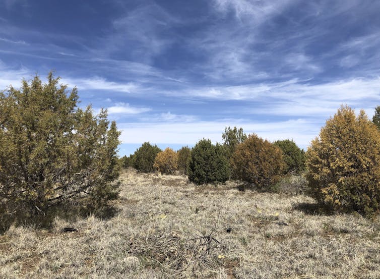
Like humans, trees need water to survive on hot, dry days, and they can survive for only short times under extreme heat and dry conditions.
During prolonged droughts and extreme heat waves like the Western U.S. is experiencing, even native trees that are accustomed to the local climate can start to die.
Central and northern Arizona have been witnessing this in recent months. A long-running drought and resulting water stress have contributed to the die-off of as many as 30% of the junipers there, according to the U.S. Forest Service. In California, over 129 million trees died as a consequence of a severe drought in the last decade, leaving highly flammable dry wood that can fuel future wildfires.
Firefighters are now closely watching these and other areas with dead or dying trees as another extremely dry year heightens the fire risk.
What happens to trees during droughts?
Trees survive by moving water from their roots to their leaves, a process known as vascular water transport.
Water moves through small cylindrical conduits, called tracheids or vessels, that are all connected. Drought disrupts the water transport by reducing the amount of water available for the tree. As moisture in the air and soil decline, air bubbles can form in the vascular system of plants, creating embolisms that block the water’s flow.
The less water that is available for trees during dry and hot periods, the higher the chances of embolisms forming in those water conduits. If a tree can’t get water to its leaves, it can’t survive.

Some species are more resistant to embolisms than others. This is why more pinon pines died in the Southwest during the drought in the early 2000s than juniper – juniper are much more resistant.
Drought stress also weakens trees, leaving them susceptible to bark beetle infestations. During the 2012-2015 drought in the Sierra Nevada, nearly 90% of the ponderosa pines died, primarily due to infestations of western pine beetles.
Fire damage + drought also weakens trees
Although fire is beneficial for fire-prone forests to control their density and maintain their health, our research shows that trees under drought stress are more likely to die from fires. During droughts, trees have less water for insulation and cooling against fires. They may also reduce their production of carbohydrates – tree food – during droughts, which leaves them weaker, making it harder for them to recover from fire damage.
Trees that suffer trunk damage in a fire are also less likely to survive in the following years if drought follows. When trees have fire scars, their vascular conduits tend to be less functional for water transport around those scars. Traumatic damage to the vascular tissue can also decrease their resistance to embolisms.
So, burned trees are more likely to die from drought; and trees in drought are more likely to die from fire.
What does this mean for future forests?
Trees in Western forests have been dying at an alarming rate over the past two decades due to droughts, high temperatures, pests and fires. As continuing greenhouse gas emissions warm the planet and drive moisture loss, increasing the frequency, duration and intensity of droughts, research shows the U.S. and much of the world will likely witness more widespread tree deaths.
The impact that changing drought and fire regimes will have on forests farther in the future is still somewhat unclear, but several observations may offer some insight.
There is evidence of a transition from forests to shrublands or grasslands in parts of the Western U.S. Frequent burning in the same area can reinforce this transition. When drought or fire alone kills some of the trees, the forests often regenerate, but how long it will take for forests to recover to a pre-fire or pre-drought condition after a large-scale die-off or severe fire is unknown.
In the past decade, the Western U.S. has witnessed its most severe droughts in over 1,000 years, including in the Southwest and California. A recent study found subalpine forests in the central Rockies are more fire-prone now than they have been in at least 2,000 years.
If there is no change in greenhouse gas emissions, temperatures will continue to increase, and severe drought stress and fire danger days will rise as a result.
Read more: Rocky Mountain forests burning more now than any time in the past 2,000 years ![]()
Daniel Johnson, Assistant Professor of Tree Physiology and Forest Ecology, University of Georgia and Raquel Partelli Feltrin, Postdoctoral Scholar in Botany, University of British Columbia
This article is republished from The Conversation under a Creative Commons license. Read the original article.