 How to resolve AdBlock issue?
News
- Details
- Written by: Lake County News reports
The LAC will be a centralized location where those affected can find assistance and access services.
Cache fire survivors can visit the LAC at the Clearlake Senior/Community Center, located at 3245 Bowers Ave. in Clearlake, on the following days:
— Wednesday, Aug. 25, from 4 to 8 p.m.;
— Thursday, Aug. 26, from 11 a.m. to 6 p.m.; and
— Friday, Aug. 27, from 10 a.m. to 2 p.m.
Disaster survivors whose homes were destroyed, or sustained damage will be able to find information and resources for property debris removal, hazardous materials cleanup, utility assistance programs, driver’s license and car registration/title replacement, local food resources, emotional support programs and much more.
Additionally, a dedicated LAC email address has been established at
- Details
- Written by: Elizabeth Larson
The meeting will begin at 9 a.m. Thursday, Aug. 26, in the board chambers on the first floor of the Lake County Courthouse, 255 N. Forbes St., Lakeport.
The agenda is here.
To participate in real-time, join the Zoom meeting by clicking this link.
The webinar ID is 970 2313 5183, the pass code is 232386.
Access the meeting via one tap mobile at +16699006833,,97023135183#,,,,*232386# or dial in at 669-900-6833.
The meeting also can be viewed on the county of Lake website and on the county’s Facebook page.
At 9:05 a.m., the commission will hold a public hearing to consider a parcel map to divide a 6.57-acre property to create two new parcels, and consideration of a categorical exemption to the California Environmental Quality Act.
The owner, Castlewood Estates LLC, is proposing a two parcel land division at 6763 Collier Ave., APN 031-071-18.
The staff report said the parcel would be divided into two equally-sized parcels, each at 3.26 acres. The first parcel contains an orchard, the second contains a high density dwelling development. There is no new development proposed or contemplated by the developer.
At 9:10 a.m., commissioners are scheduled to hold a public hearing to consider a major use permit for 12 commercial cannabis licenses sought by BG Property Management LLC for an operation to be located at 9200, 9100 and 8722 Highland Springs Road, Lakeport, APNs 007-006-45, 10 and 43.
The project consists of 346,667 square feet of outdoor cannabis cultivation, 48,000 square feet of indoor (greenhouse) cannabis cultivation, a 10,000 square foot drying building, an A-Type 4 nursery license, a Type 13 self-distribution licenses and consideration of adoption of a mitigated negative declaration.
The staff report said that, according to water use studies of Northern California, cannabis plants use approximately 5.99 gallons of water per day. “It has also been documented through CalCannabis’ Final Programmatic Environmental Impact Report that outdoor cannabis uses between 25-35 inches of water per year. Based on these ranges, the project’s Water Use Management Plan included as part of the Property Management Plan estimates that the project’s water demand would be between 4,860,640 to 6,075,801 gallons (best case) and 7,290,961 to 8,506,121 gallons (worst case) with an average estimate of 4,860,640 gallons per year.”
The report said water consumption would vary, with the highest consumption occurring during the summer months — June, July, August and September.
Email Elizabeth Larson at
- Details
- Written by: Lake County News reports
The company said the ever-expanding network of weather stations is positioned to refine the scope of public safety power shutoff events and prepare for increasingly common severe weather events.
More than 200 new weather stations have been installed this year alone, 13 of those are in Lake County, bringing the total number of weather stations in Lake County to 43.
PG&E plans to have a total of 1,300 weather stations in place by the end of 2021. This will equip the company with one weather station for every 20-line miles of electric distribution circuits within Tier 2 and Tier 3 High Fire-Threat Districts, as designated by the California Public Utilities Commission.
Data captured by the weather stations such as temperature, wind speed and humidity levels help PG&E meteorologists evaluate where severe weather may be headed and inform utility operational planning.
During a PSPS, PG&E turns off specific power lines, based on severe weather conditions, for public safety. This is to prevent tree branches and other debris from contacting energized power lines.
“We know that losing power disrupts lives, especially for our customers with medical needs. That is why we are finding ways to reduce the impact of PSPS events without compromising safety. The sole focus of a PSPS is to keep our customers safe,” said Mark Quinlan, vice president of PSPS Operations and Execution.
Since 2018, PG&E has installed more than 1,200 weather stations mostly across high fire-threat areas in Northern and Central California.
The newest weather stations in Lake County are installed in the following locations:
— Gray Road, near Seigler Springs Road;
— Noyes Ranch Road, near Bucksnort Creek;
— Verna Way, near Kono Tayee Point;
— Ridge Road, Highland Creek area;
— Liberty Lane, Hidden Valley;
— Middletown South, east of Highway 29;
— Francis Lane, near Tinilyn Drive, Hidden Valley Lake;
— New Long Valley Road;
— Benmore Valley Road, north of Hopland Rancheria;
— Elk Mountain Road, Mendocino National Forest;
— Daly Place, near Jerusalem Grade, Lower Lake;
— Humboldt 140 (Morgan Valley Road), Lower Lake; and
— PG&E Access Road, Cooper.
“Observations from the weather stations contribute to the improvement of our predictive capabilities for PSPS events. We now have a historical database of these observations, many in remote areas where we have never had this level of detailed data before, and it is now used to help fine-tune our models to better predict when critical fire weather conditions may occur,” said Ashley Helmetag, Senior PG&E Meteorologist. “As the model is improved, the forecast becomes more accurate, allowing meteorologists to limit the scope of PSPS events to the areas where the riskiest fire weather conditions are expected, and to do so with higher confidence.”
These new weather stations across PG&E’s service territory are now sending hyperlocal data not only to PG&E meteorologists, but also to analysts and experts in PG&E’s Wildfire Safety Operations Center, or WSOC.
The WSOC is the hub where PG&E detects, evaluates, monitors, and responds to wildfire threats across its service area.
The information from these stations is also viewable by the public at www.pge.com/weather and is combined with other weather station information and shared with partners through MesoWest.
Weather stations are just one part of PG&E’s Community Wildfire Safety Program. The program also includes the installation of hundreds of sectionalizing devices to break the grid into smaller pieces and hardening hundreds of miles of lines, poles, and other infrastructure to reduce wildfire risk and lessen the effects of PSPS events on customers.
Coupled with PG&E’s growing network of weather data, temporary generation and microgrids, these tools and technologies helped keep the lights on for hundreds of thousands of customers during the PSPS events in 2020, as compared to those events in 2019.
- Details
- Written by: Elizabeth Larson
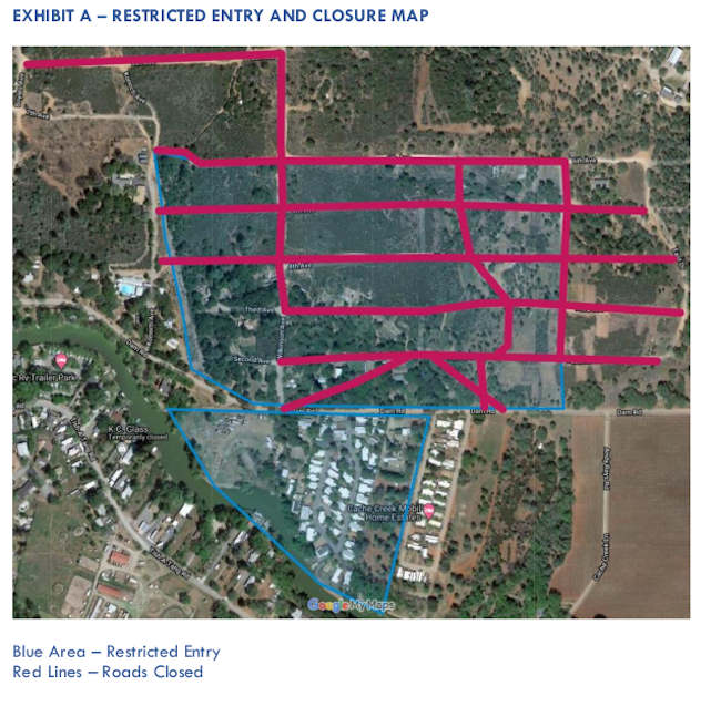
Some residents were allowed to begin returning home during a two-hour window on Sunday evening, and then on Monday morning, city officials lifted the remaining evacuation order for the area south of 18th Avenue and east of Highway 53.
At the same time, in his capacity as the city’s director of emergency services, City Manager Alan Flora issued a directive on Monday morning that restricts access for those who aren’t property owners, residents, their agents or a specified group of other individuals to an area that includes the area south of Dam Road to Cache Creek, from 16335 Dam Road to the west and the western border of 16535 Dam Road, which is Cache Creek Mobile Home Estates, and areas on Sixth Avenue and Cache Street up to Dam Road.
The fire, which began on the afternoon of Wednesday, Aug. 18, burned 83 acres, destroyed 56 homes — 46 mobile homes and 10 stick-built homes — and 81 outbuildings, officials reported.
Much of the damage was in the Creekside Mobile Home Park, and while fewer homes were damaged in the nearby Cache Creek Mobile Home Park, its water system was destroyed, officials reported.
Supervisor Bruno Sabatier said Foods, Etc. donated bottled water so Cache Creek Mobile Home Park residents could still go home and have water to drink, cook and do basic washing.
He also praised Frank Costner, general manager of Konocti County Water District and his crew for working to connect Cache Creek Mobile Home Park’s water system to the district’s. That work was still taking place on Monday night.
City officials had reported last week that Konocti County Water District had been poised to take over the park’s system at the time the fire hit.
Clearlake Police Chief Andrew White said Costner’s support for allowing the police department to co-locate a radio site at one of the district’s water tanks a few years ago directly contributed to police being able to communicate during the Cache fire’s evacuations.
An evacuation shelter run by the Red Cross remains open at the city’s senior and community center, 3245 Bowers Ave.
Sabatier said planning is underway to open a local assistance center for fire survivors, with nonprofits ready to offer assistance.
The Lake Area Rotary Club Association also is once again raising funds for fire relief. Donations can be made online or sent via check to the LARCA Emergency Relief Fund, P.O. Box 2921, Clearlake, CA 95422.
The city of Clearlake also has added a Cache fire resources page to its website.
Email Elizabeth Larson at