 How to resolve AdBlock issue?
News
- Details
- Written by: Maureen C Kennedy, University of Washington; Don McKenzie, University of Washington, and Jeremy Littell, US Geological Survey
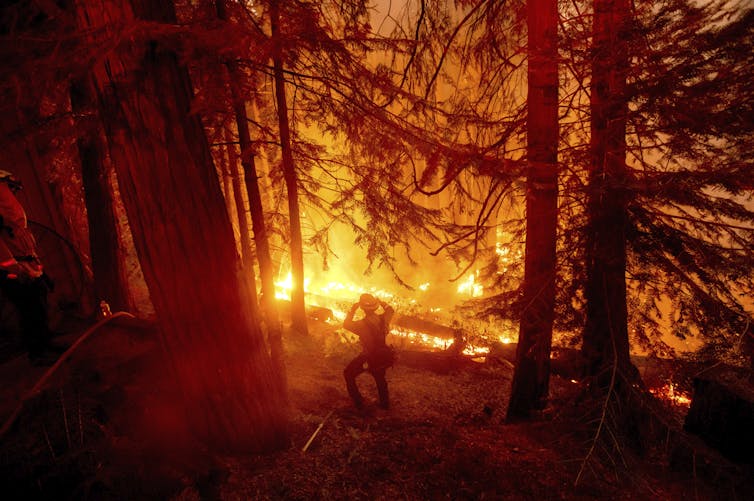
There is abundant evidence that changes in the climate, both increased temperature and reduced precipitation, are making wildfires worse in the western U.S. The relationship between climate and wildfire seems obvious and universal: hotter + drier = more and worse wildfire.
Yet the diversity of wildland areas in the western U.S. means that not all ecosystems respond in the same way to a hotter and drier climate. Understanding how and why climate change has different effects on wildfire is essential for effective management of our natural areas.
Why do areas respond differently?
Similar to campfires, wildfires require fuel to burn: parts of trees and shrubs, the leaves, twigs and branches. Dried grasses, too, will work. The growth of this vegetation depends on water, and water availability depends on the climate.
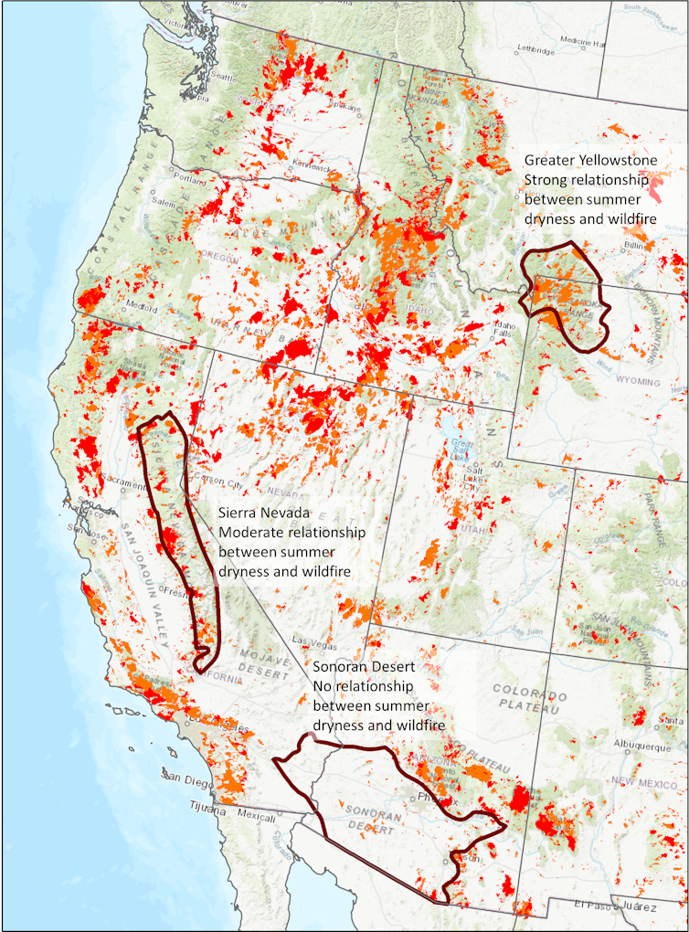
How hot and dry the climate is in an area influences the amount of fuel that is available to burn and the strength of the relationship between wildfire and climate. Ecologists such as us calculate how closely related wildfire area burned is to how hot and dry it is during the summer, and we have found that the relationship does indeed vary.
Areas that are historically cool and wet have a lot of fuel, but the fuel has to be dry enough to burn, so the relationship in these areas between wildfire and climate is very strong. Areas that are historically warm and dry have less fuel, often not enough fuel for a large wildfire even if it is very dry.
Let’s consider one extreme. The Sonoran Desert in Arizona is persistently hot and dry, and vegetation is sparse. The dryness of the summer, what we call the “summer water deficit,” does not control the extent and severity of wildfires. Summer is almost always hot and dry enough to burn, and how much it burns depends on the amount of fuel. No matter how much hotter and drier the climate becomes, wildfire is not going to increase unless more fuel appears on the landscape. Unfortunately, exotic grasses that are adapted to wildfire are invading much of the American Southwest, including the Sonoran Desert, providing that extra fuel.
At the other extreme are mountain forests, such as Yellowstone National Park and the surrounding area, that have abundant vegetation and fuel and are cooler and wetter. There, the amount of land that burns is strongly related to the summer water deficit. Hotter and drier summers are likely to increase wildfire activity.
What about areas in between these two extremes?
Where hotter and drier can eventually mean less fire
In California, wildfires in the dry forests of the Sierra Nevada are partly controlled by summer water deficit. For a while, hotter and drier summers are likely to increase the amount of land burned each year.
We ran computer simulations of the interactions among climate, plant growth and wildfire for one area within the Sierra Nevada. In the first decade of the simulations, an initial burst of large areas burned each year. This first pulse of wildfire burned more area in a scenario with increased drought and temperature than in the historical climate, just as we are seeing in the recent extreme fire seasons in the Sierra Nevada.
Over time, however, climate change will modify how plants grow. Persistently hotter and drier climate over decades will increase the number of dead and dying trees and decrease new growth. Eventually less fuel is available to burn as the dead trees decompose and fewer live ones replace them.
The same computer simulations show that the initial pulse of wildfires removes a lot of dense vegetation, and subsequent fires become smaller compared with fires in historical climate conditions and with increased drought and temperature. Furthermore, because hotter and drier conditions can eventually lead to less fuel development, the wildfire area burned over 60 years may be smaller with increased drought and temperature than in the historical climate.
Less wildfire due to climate change may sound like good news, but how it occurs is not necessarily a desirable outcome for these forests. In the simulations, reduced wildfire is a consequence of extreme water limitation that results in reduced forest biomass. This means less tree growth and more dying trees that eventually result in a thinner and less productive forest. If the climate changes enough, the trees may even be replaced by shrubs, which have their own unique relationship between climate and wildfire.
The problem with quickly putting out every fire
Human actions, in particular putting out every fire, have changed how dry forests burn.
Some fires are started by lightning, but Indigenous peoples burned the landscape frequently, reducing fuels, so the spread and intensity of subsequent wildfires was more limited. After European colonization, the U.S. government spent more than a century actively suppressing wildfires. As a result, many forests became choked with excess fuels. Even without climate change, excess fuels increase the wildfire hazard.
The effect of that fire suppression on current wildfire hazards can also vary from region to region.
In cooler and wetter areas, climate change can have a stronger effect on wildfires than fire suppression. These are the areas with naturally abundant fuel and strong relationships between climate and wildfire. In drier systems, where fuels were historically low and had limited wildfire spread, suppression over the past century can have a stronger effect on current wildfire hazard than in wetter areas. It is important to consider climate change, regional characteristics and land management, all of which affect the fuels that are available to burn in a wildfire.
What to do about wildfire
There is no single solution to the increasing wildfire activity and declining health of forests.
The global solution would be to slow and eventually reverse climate change. More locally, combining prescribed fires, which are intentionally set in relatively mild weather conditions, with mechanical removal of small trees and ground fuels is the best way to prevent more severe wildfires.
Increasing the use of prescribed fire or allowing wildfires to burn under safe conditions can restore some forests to be more resilient – those that have excess fuel from fire suppression – and reduce the hazards that the western U.S. is seeing now. Past wildfires can limit the spread of new wildfires by reducing the amount of vegetation and fuel available to burn.

Over the past five years, wildfires in the U.S. burned an average of 7.8 million acres annually, which cost an average of US$2.4 billion per year to fight.
Managing forests in the face of the threat of larger, more severe wildfires in a warming climate presents a huge challenge to fire managers, given the costs of treatments and the millions of acres that could benefit from them. Plenty of wildland is still primed to burn, and understanding the intricate relationship among climate, fuels and wildfire can help managers prioritize areas where more fire will be beneficial and areas where different approaches may be preferred.
[Understand new developments in science, health and technology, each week. Subscribe to The Conversation’s science newsletter.]![]()
Maureen C Kennedy, Assistant Professor of Quantitative Fire Ecology, University of Washington; Don McKenzie, Professor of Environmental and Forest Sciences, University of Washington, and Jeremy Littell, Research Ecologist - Climate Impacts, US Geological Survey
This article is republished from The Conversation under a Creative Commons license. Read the original article.
- Details
- Written by: NATIONAL AERONAUTICS AND SPACE ADMINISTRATION
A new video rings in the rover’s ninth year on Mars, letting viewers tour Curiosity’s location on a Martian mountain.
Images of knobbly rocks and rounded hills are delighting scientists as NASA’s Curiosity rover climbs Mount Sharp, a 5-mile-tall mountain within the 96-mile-wide basin of Mars’ Gale Crater.
The rover’s Mast Camera, or Mastcam, highlights those features in a panorama captured on July 3, 2021 (the 3,167th Martian day, or sol, of the mission).
This location is particularly exciting: Spacecraft orbiting Mars show that Curiosity is now somewhere between a region enriched with clay minerals and one dominated by salty minerals called sulfates.
The mountain’s layers in this area may reveal how the ancient environment within Gale Crater dried up over time. Similar changes are seen across the planet, and studying this region up close has been a major long-term goal for the mission.
“The rocks here will begin to tell us how this once-wet planet changed into the dry Mars of today, and how long habitable environments persisted even after that happened,” said Abigail Fraeman, Curiosity’s deputy project scientist, at NASA’s Jet Propulsion Laboratory in Southern California.
Nine years on Mars
Curiosity landed nine years ago, on Aug. 5, 2012 PDT (Aug. 6, 2012 EDT), to study whether different Martian environments could have supported microbial life in the planet’s ancient past, when lakes and groundwater existed within Gale Crater.
The rover pulverizes rock samples with a drill on its robotic arm, then sprinkles the powder into the rover’s chassis, where a pair of instruments determines which chemicals and minerals are present.
Curiosity recently drilled its 32nd rock sample from a target nicknamed “Pontours” that will help detail the transition from the region of clay minerals to the one dominated by sulfates.
Because it’s winter at Curiosity’s location, the skies in the new panorama are relatively dust-free, providing a clear view all the way down to Gale Crater’s floor. It’s provided an opportunity for the mission team to reflect on the 16 miles Curiosity has driven during the mission.
“Landing day is still one of the happiest days of my professional career,” said the mission’s new project manager, Megan Richardson Lin of NASA’s Jet Propulsion Laboratory in Southern California. Lin started working on Curiosity just before it launched, joining the surface operations team shortly afterward. She’s held several roles on the mission since then. “We’re driving a robot as it explores another planet. Seeing how new discoveries and scientific results guide each day’s activities is extremely rewarding.”
There’s more to discover on the road ahead. Curiosity has already started up a path winding between “Rafael Navarro Mountain,” recently nicknamed to honor a deceased mission scientist, and a towering butte that’s taller than a four-story building.
In the coming year, the rover will drive past these two features into a narrow canyon before revisiting the “Greenheugh Pediment,” a slope with a sandstone cap that the rover briefly summited last year.
More about Curiosity is at https://mars.nasa.gov/msl/home/ and https://nasa.gov/msl/.
- Details
- Written by: Elizabeth Larson
The fire, burning since Wednesday afternoon, remained at 83 acres on Friday, with containment up to 45%, said Lake County Fire Chief Willie Sapeta.
Early Saturday, one zone in Lake County’s Zonehaven system remained under mandatory evacuation, Zone CLE-E157, which contains everything in the city of Clearlake to the south of 18th Avenue and east of Highway 53 except for Adventist Health Clear Lake Hospital.
City Manager Alan Flora said he visited the fire scene on Friday morning and there were a few hotspots to deal with but little fire activity.
He said the hope is that evacuees can return home on Sunday, but added that a lot of work by Pacific Gas and Electric to replace damaged power infrastructure remains to be done.
Overall, Sapeta — who was one of the first on scene at the incident, which is estimated to have destroyed 137 structures, including 56 homes — said the progress on the fire was “looking good.”
What’s not looking good is the prospects for the city of Clearlake to get help in the complex task of recovery.
City officials have acknowledged that because the fire doesn’t meet the thresholds for state and federal disaster assistance — as has been the case with most of Lake County’s destructive fires — much of the multimillion dollar recovery process and its cost could end up falling on the city.
Flora said the state is going to provide very limited resources to the city for the incident.
He said the city will get a hazmat team from the Department of Toxic Substances Control, which is waiting on the county of Lake to declare a public health emergency so the phase one cleanup can begin.
“Hopefully that will be soon,” said Flora.
As of Friday, that public health emergency had not been agendized by the Board of Supervisors for its next meeting on Tuesday.
Flora said the state hazmat team won’t address any debris clean up from homes or vehicles.
He said the city is working with Assemblywoman Cecilia Aguiar-Curry and Sen. Mike McGuire to try to piece together a solution or the cleanup, but he said so far they have no solid plan.
“We are still working to see if we can get any short term housing assistance for those that lost their homes, but nothing happening yet from the state on that front,” Flora said.
He also didn’t have a dollar estimate for damage.
Flora said that estimate has to be submitted by the California Office of Emergency Services by Wednesday, “so it will start coming together soon.”
Email Elizabeth Larson at
- Details
- Written by: Lake County News reports
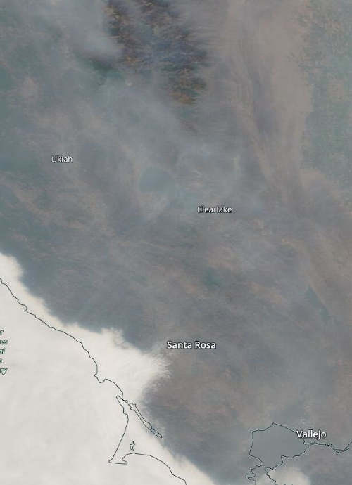
LAKE COUNTY, Calif. — Lake County has continued to experience smoky skies this week due to regional wildland fires and the Cache fire in Clearlake, but conditions are expected to begin to improve over the weekend.
The Lake County Air Quality Management District said the air basin continues to be impacted.
Calmer winds along with relatively stable air have settled over the region. The district said the lack of mixing and westerly winds resulted in all areas of Lake County experiencing intermittent air quality impacts from “unhealthy for sensitive groups” to “hazardous” on Friday.
For Saturday, the air quality forecast will range from “unhealthy for sensitive groups” (Air Quality Index of 101 to 150) to “unhealthy” (AQI of 151-200) with areas at higher elevations experiencing the most smoke impact.
The district said current weather models indicate that there will be some smoke clearing on Saturday and significant clearing on Sunday. Most areas should reach the “moderate” or “good” thresholds.
The National Weather Service forecast calls for widespread haze during the day on Saturday, with clearer conditions at night and on Sunday as light winds move over the area.
Visit the Lake County Air Quality Management District’s website and follow the Quick Links for Air Monitoring for current smoke and air quality conditions.