 How to resolve AdBlock issue?
News
- Details
- Written by: Elizabeth Larson
The visualizations can be found here.
Last month, the supervisors approved a resolution to the redistricting commission calling for all of Lake County to be kept in a single congressional district that included both Napa and Sonoma counties. The city of Clearlake submitted a similar resolution to the commission.
However, the initial visualizations show Lake County being grouped with Mendocino, Humboldt, Del Norte, Trinity, and portions of Siskiyou and Sonoma counties for its congressional and State Assembly seats, and with Napa and Solano counties for the State Senate.
Based on that initial scenario, Lake County could see all of its representation completely change.
Pedro Toledo, one of the 14 members of the California Citizens Redistricting Commission and a Sonoma County resident, said he can understand why local leaders would be upset.
“These maps are not the final maps. They're not even the draft maps. They are to start conversation,” he said.
Toledo said there will be a lot of changes and refinements before maps are drawn and finalized, noting he has a lot of comments and directions to give those drawing the lines himself.
He said the proposed districts will probably shift, “and they may shift a lot,” and once they get into the actual map drawing phase in a few weeks, more changes can be expected.
The California Citizens Redistricting Commission is due to discuss the latest developments in the process at its visualizations meeting, which takes place from Wednesday through Friday in Los Angeles.
The meeting agenda is here.
It can be viewed via livestream at https://WeDrawTheLinesCA.org/meetings.
The meeting on Wednesday begins at 1 p.m.
To submit your comments, visit the commission website and scroll down to “Visualizations Feedback Form,” which is in the section providing information on the commission’s Oct. 27 meeting, below the welcome text and four action buttons (“Sign Up,” “Participate,” “Request Presentation” and “Visualizations”).
Toledo told Lake County News in a Tuesday night phone interview that the commission is expected to discuss the Northern California visualizations first once it emerges from a planned closed session on Wednesday afternoon.
He said the meeting will be the first opportunity for the commission to sit down and look at the state completely drawn out.
“We’ll be tackling the whole state at that point, starting with the north,” Toledo said.
Toledo said it’s the perfect time for local officials and community members to weigh in on the work so far. “We need community feedback to be able to draw these lines correctly.”
Board voices disapproval for visualizations
A link to the visualizations was released by the commission in an email shortly after 4:30 p.m. Tuesday.
About a half-hour later, the Board of Supervisors emerged from a closed session for department head evaluations and voted to add an extra item to the agenda in order to discuss the visualizations, with Board Chair Bruno Sabatier noting that the matter had come up unexpectedly.
After a short discussion, the board voted unanimously to send a letter to the commission voicing its concerns in response to the initial visualizations.
County Administrative Officer Carol Huchingson said her staff, including Deputy Administrative Officer Matthew Rothstein, had worked quickly to draft the letter, which can be seen below.
Supervisor Jessica Pyska read a line from the commission’s email announcing the visualizations, which said, “You told us which communities you wanted to be grouped together with, and which you did not want to be grouped with, and we listened. This week's new set of visualizations is based upon feedback given to the line drawing team by the commissioners during the last round of deliberations.”
She and other board members said they didn’t feel like the commission had listened to them based on what was presented on Tuesday.
“If they are saying they listened, they went exactly opposite of what we asked them to do,” said Sabatier.
Clearlake City Manager Alan Flora, who joined the meeting via Zoom, said the city also is “extremely concerned” and plans to submit a letter similar to the board’s.
“It’s very troubling that all of our state and federal representation would change,” Flora said.
That’s a concern that Sabatier said flustered him, and board members felt the result of the redistricting process so far appears detrimental for the county.
The final version of the letter notes that the total loss of alignments in the county’s State Assembly, State Senate and congressional districts, “would be a great disservice to Lake County at what is a critical time.”
Lake County’s unique concerns
Toledo told Lake County News in a September interview that the commission’s goal, based on requests from local officials and residents, was to keep Lake County and its cities together as much as possible, and that the census data would tell the commission if it could do that.
So far, Lake County is being kept together as a whole in the visualizations. However, Toledo said there are still multiple scenarios for how it could ultimately be settled in a new district.
While the visualizations have Lake County either wrapped into a larger North Coast district or put with Napa and Solano counties, Toledo said there are other options as well.
“There is quite a bit of discussion on the commission on where Lake County should land,” Toledo said.
Over the last couple of weeks, based on community input, Toledo said some commissioners are seeing Lake County more closely connected to Mendocino and the far north.
“We also see the connection that Lake County has with Napa and Sonoma,” Toledo said, explaining that those are the areas Lake County has been connected to in public input.
Ultimately, he said it really will come down to the input from Lake County residents, governments and businesses, as well as the surrounding communities.
He said the commission has not received any input from nearby communities that don’t want to be with Lake County — which they have had happen for some other counties.
“Everyone is very receptive to having Lake in their area,” he said.
He said the commission will take input from Lake County and do all it can to make sure it’s in the district where its residents and leaders want it to be.
The process so far and what’s to come
The commission has been at work since last year preparing to begin drawing the new boundaries, a job that happens every 10 years, with the release of the new census data.
In late September, the commission received data it needed from the US Census Bureau, which was itself delayed in its work by the pandemic.
The University of California, Berkeley, made additional adjustments to the data to account for state requirements to count prison inmates in their home counties in order for the commission to start its process.
The state redistricting commission had an initial deadline to complete its work by Dec. 15. Toledo said they asked the California Supreme Court to have the deadline moved back to Jan. 14 to make sure county elections offices would have time to implement the final maps, which will be used for the June primaries.
Instead, the Supreme Court gave the commission until Dec. 27, which he said is challenging due to being in the middle of the holidays.
Even so, he thinks the commission is on schedule to get its work done, and in the process offer more public opportunity for input than was done 10 years ago through the visualization process, which is new.
Challenges this year include accounting for the loss of one congressional seat in California, bringing the total to 52. Toledo said each district must have 750,000 residents in it. The State Assembly districts have more discretion.
There are other criteria as well, including voting rights rules. “It's like putting a jigsaw puzzle together,” he said.
Once the commission received the census data, it started the process of visualizing, which is where it is now. That step has involved working to align communities of interest data with the data from the Census Bureau, Toledo explained.
Toledo said the commission has gone through many iterations of the visualizations over the last couple of weeks.
He said over the next two weeks the commission will finalize the visualizations before moving into the draft maps. “We’ve been getting so much community feedback and input form across the state of California,” said Toledo, adding that he thinks they have tackled most of the difficult issues.
When the commission gets to the map drawing, it will use a live drawing process that allows them to take more community input. Toledo said those on-the-spot drawings will allow people to see what the commission is thinking.
They’ll start with State Assembly districts, which Toledo said tend to be building blocks of the State Senate districts.
Toledo emphasized that community input is critical at this stage.
For information on how to participate, visit the commission’s website. Members of the public also can sign up for notifications from the commission here.
Email Elizabeth Larson at
102621 Lake County Letter of Opposition by LakeCoNews on Scribd
092821 BOS resolution on redistricting by LakeCoNews on Scribd
- Details
- Written by: Elizabeth Larson
The meeting will begin at 9 a.m. Thursday, Oct. 28, in the board chambers on the first floor of the Lake County Courthouse, 255 N. Forbes St., Lakeport.
The agenda is here.
To participate in real-time, join the Zoom meeting by clicking this link.
The webinar ID is 913 7825 1263, the pass code is 824276.
Access the meeting via one tap mobile at +16699006833,,91378251263#,,,,*824276# or dial in at 669-900-6833.
The meeting also can be viewed on the county’s website or Facebook page.
In an item scheduled for 9:20 a.m., the commission will reconsider approving the use permit sought by WeGrow LLC, owned by Zarina Otchkova.
The 309-acre Middletown property is located at 16750 Herrington Road, 17610 Sandy Road and 19678 Stinson Road. The nine-acre cultivation site is at the Herrington Road location.
Otchkova proposes a project that includes 32 90-foot by 125-foot greenhouses, two 90-foot by 125-foot greenhouses for immature plant starts, four 50-foot by 100-foot drying buildings, one 200 square foot shed, 20 5,000 gallon water tanks, one 6-foot-tall galvanized woven wire fence covered with privacy mesh to screen the greenhouses from public view.
The project will remove 100 blue oak trees, which will require a three to one ratio tree replacement using similar species trees before cultivation starts.
In June, the Board of Supervisors upheld an appeal against the project, due to questions about the environmental analysis.
However, the board approved the appeal without prejudice, which allowed Otchkova to reapply for the project after further study.
In other businesses, the commission will consider Lake Vista Farms LLC’s project at 2050 and 2122 Ogulin Canyon Road in Clearlake with up to 25.8 acres of cannabis, and modifications to existing projects, Green Bear Farms Cali LLC at 4680 Clark Drive in Kelseyville and Sunny S Ranch at 19424 Butts Canyon Road in Middletown.
The full agenda follows.
AGENDA
Consideration of the approval of minutes from the Oct. 14 Planning Commission Meeting.
Consideration of proposed 2022 planning commissioner regular meeting calendar.
9:05 a.m.: Public hearing to consider major use permit (UP 19-36). Applicant: Brian D. Pensack and Garrett W. Burdick (Lake Vista Farms LLC). Owner: Lake Vista Farms LLC. Proposed project: Applicant is applying for 15 acres of outdoor commercial cannabis canopy area within five fenced cultivation areas, up to 25.8 acres. Cultivation accessory items include portable toilets, trash enclosures, vegetative waste storage area, 2,500-gallon water storage tanks at each cultivation area, and Conex shipping containers and/or 8-foot by 8-foot storage sheds (or similar) for storage of pesticides, fertilizers and hazardous materials. On-site nursery within an existing barn. Renovated 10-foot by 30-foot shipping container to house security equipment and camera monitors, and 6-foot-tall security fencing, secured by locked gates, to enclose cultivation areas. Address: 2050 and 2122 Ogulin Canyon Road, Clearlake. (Planner Michael Taylor)
9:10 a.m.: Public hearing to consider approving modification (MMU 21-22) of original Use Permit UP 18-35. Applicant/owner: Green Bear Farms Cali LLC / Wais Amin. Proposed Project: Amendment to original canopy/cultivation area; 16 additional greenhouses, and one A-Type 13 Self Distribution license to allow legal transport of cannabis to and from the site. Location: 4680 Clark Drive, Kelseyville. (Planner Eric Porter)
9:15 a.m.: Public hearing to consider approving modification (MMU 21-20) of original Use Permit UP 18-43. Applicant/owner: Sunny S Ranch/Shannon Sanders. Proposed project: Four 2,499 square foot nursery areas (greenhouses) for immature cannabis plants in conjunction with previously approved file No. User Permit 18-43. Location: 19424 Butts Canyon Road, Middletown. (Planner Eric Porter)
9:20 a.m. Public hearing to reconsider approving Use Permit UP 20-22. Applicant/Owner: WeGrow LLC/Zarina Otchkova. Proposed project: 15 A-Type 3B mixed light commercial cannabis cultivation licenses and one A-Type 13 “self distribution” license. The applicant is proposing 32 90-foot by 125-foot greenhouses, two 90-foot by 125-foot greenhouses for immature plant starts, four 50-foot by 100-foot drying buildings, one 200 square foot shed, 20 5,000 gallon water tanks, one 6-foot-tall galvanized woven wire fence covered with privacy mesh to screen the greenhouses from public view. Total proposed cultivation area is 387,600 square feet (roughly nine acres); total proposed canopy area is 330,000 square feet. The applicant is also proposing the removal of 100 blue oak trees, which will require a 3:1 tree replacement using similar species trees before the start of cultivation. Location: 16750 Herrington Road, Middletown (cultivation site); 17610 Sandy Road, Middletown, CA and 19678 Stinson Road, Middletown consisting of 309-plus acres. (Planner Eric Porter)
Email Elizabeth Larson at
- Details
- Written by: Elizabeth Larson
During the seven-minute meeting, the council voted unanimously to approve a resolution to implement the new increased rates from 2022 to 2026.
In its regular meeting last week, the council held a public hearing that led to two unanimous votes on resolutions for water and sewer rate increases.
However, a 1954 ordinance in city municipal code requires that any resolution to increase water rates must have two readings, rather than one.
That necessitated the council holding the special meeting on Tuesday night.
There was no public comment before the council took its vote and adjourned.
City officials said the new water and sewer rates will go into effect on Nov. 1.
The new rates will support the city’s plans for $7 million in capital utility projects over the coming five years.
Email Elizabeth Larson at
- Details
- Written by: Tom Corringham, University of California San Diego
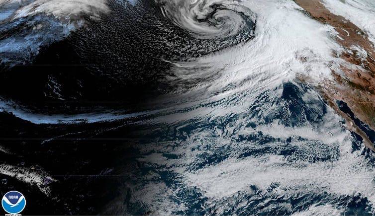
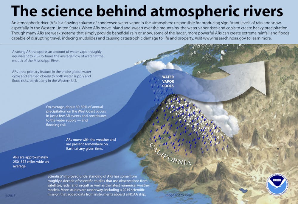
Ask people to name the world’s largest river, and most will probably guess that it’s the Amazon, the Nile or the Mississippi. In fact, some of Earth’s largest rivers are in the sky – and they can produce powerful storms, like the ones now drenching northern California.
Atmospheric rivers are long, narrow bands of moisture in the atmosphere that extend from the tropics to higher latitudes. These rivers in the sky can transport 15 times the volume of the Mississippi River.
When that moisture reaches the coast and moves inland, it rises over the mountains, generating rain and snowfall. Many fire-weary westerners welcome these deluges, but atmospheric rivers can trigger other disasters, such as extreme flooding and debris flows.
In the past 20 years, as observation networks have improved, scientists have learned more about these important weather phenomena. Atmospheric rivers occur globally, affecting the west coasts of the world’s major land masses, including Portugal, Western Europe, Chile and South Africa. So-called “Pineapple Express” storms that carry moisture from Hawaii to the U.S. West Coast are just one of their many flavors.
My research combines economics and atmospheric science to measure damage from severe weather events. Recently I led a team of researchers from Scripps Institution of Oceanography and the Army Corps of Engineers in the first systematic analysis of damages from atmospheric rivers due to extreme flooding. We found that while many of these events are benign, the largest of them cause most of the flooding damage in the western U.S. And atmospheric rivers are predicted to grow longer, wetter and wider in a warming climate.
Rivers in the sky
On Feb. 27, 2019, an atmospheric river propelled a plume of water vapor 350 miles wide and 1,600 miles long through the sky from the tropical North Pacific Ocean to the coast of Northern California.
Just north of San Francisco Bay, in Sonoma County’s famed wine country, the storm dumped over 21 inches of rain. The Russian River crested at 45.4 feet – 13.4 feet above flood stage.
For the fifth time in four decades, the town of Guerneville was submerged under the murky brown floodwaters of the lower Russian River. Damages in Sonoma County alone were estimated at over US$100 million.
Events like these have drawn attention in recent years, but atmospheric rivers are not new. They have meandered through the sky for millions of years, transporting water vapor from the equator toward the poles.
In the 1960s meteorologists coined the phrase “Pineapple Express” to describe storm tracks that originated near Hawaii and carried warm water vapor to the coast of North America. By the late 1990s atmospheric scientists had found that over 90% of the world’s moisture from the tropics and subtropics was transported to higher latitudes by similar systems, which they named “atmospheric rivers.”
In dry conditions, atmospheric rivers can replenish water supplies and quench dangerous wildfires. In wet conditions, they can cause damaging floods and debris flows, wreaking havoc on local economies.

Helpful and harmful
Researchers have known for some time that flooding due to atmospheric rivers could cost a lot of money, but until our study no one had quantified these damages. We used a catalog of atmospheric river events compiled by Scripps Institution of Oceanography’s Center for Western Weather and Water Extremes, and matched it to 40 years of flood insurance records and 20 years of National Weather Service damage estimates.
We found that atmospheric rivers caused an average of $1.1 billion in flood damages yearly in the western U.S. More than 80% of all flooding damages in the West in the years we studied were associated with atmospheric rivers. In some areas, such as coastal northern California, these systems caused over 99% of damages.
Our data showed that in an average year, about 40 atmospheric rivers made landfall along the Pacific coast somewhere between Baja California and British Columbia. Most of these events were benign: About half caused no insured losses, and these storms replenished the region’s water supply.
But there were a number of exceptions. We used a recently developed atmospheric river classification scale that ranks the storms from 1 to 5, similar to systems for categorizing hurricanes and tornadoes. There was a clear link between these categories and observed damages.
Atmospheric River category 1 (AR1) and AR2 storms caused estimated damages under $1 million. AR4 and AR5 storms caused median damages in the 10s and 100s of millions of dollars respectively. The most damaging AR4s and AR5s generated impacts of over $1 billion per storm. These billion-dollar storms occurred every three to four years.
A moister atmosphere means worse storms
Our most significant finding was an exponential relationship between the intensity of atmospheric rivers and the flood damages they caused. Each increase in the scale from 1 to 5 was associated with a 10-fold increase in damages.
Several recent studies have modeled how atmospheric rivers will change in the coming decades. The mechanism is simple: Greenhouse gases trap heat in the atmosphere, warming the planet. This causes more water to evaporate from oceans and lakes, and increased moisture in the air makes storm systems grow stronger.
Like hurricanes, atmospheric rivers are projected to grow longer, wider and wetter in a warming climate. Our finding that damages increase exponentially with intensity suggests that even modest increases in atmospheric river intensity could lead to significantly larger economic impacts.
Better forecasting is critical
I believe that improving atmospheric forecasting systems should be a priority for adapting to a changing climate. Better understanding of atmospheric rivers’ intensity, duration and landfall locations can provide valuable information to residents and emergency responders.
It also is important to discourage new construction in high-risk areas and help people move to safer locations after major disasters, rather than rebuilding in place.
Finally, our study underlines the need to reduce global greenhouse gas emissions. These storms will keep coming, and they’re getting stronger. In my view, stabilizing the global climate system is the only long-term way to minimize economic damage and risk to vulnerable communities.
[Like what you’ve read? Want more? Sign up for The Conversation’s daily newsletter.]![]()
Tom Corringham, Postdoctoral Scholar in Climate, Atmospheric Science and Physical Oceanography, University of California San Diego
This article is republished from The Conversation under a Creative Commons license. Read the original article.