 How to resolve AdBlock issue?
News
- Details
- Written by: Daniel Herrera, George Mason University and Travis Gallo, George Mason University

Should domestic cats be allowed to roam freely outdoors? It’s a contentious issue. Those who say yes assert that they’re defending outdoor cats and the people who care for them. Critics respond that free-roaming cats kill so many birds, reptiles, mammals and important insects like butterflies and dragonflies that they threaten biodiversity on a global scale.
As conservation biologists familiar with these clashing viewpoints, we wondered whether there was room for a more nuanced strategy than the typical yes/no standoff. In a recently published study, we used camera traps at hundreds of sites across Washington, D.C., to analyze the predatory behavior of urban free-roaming cats. The cameras recorded all cats that passed them, so our study did not distinguish between feral cats and pet cats roaming outdoors.
Our data showed that the cats were unlikely to prey on native wildlife, such as songbirds or small mammals, when they were farther than roughly 1,500 feet (500 meters) from a forested area, such as a park or wooded backyard. We also found that when cats were approximately 800 feet (250 meters) or farther from forest edges, they were more likely to prey on rats than on native wildlife.
Since the average urban domestic cat ranges over a small area – roughly 550 feet (170 meters), or one to two city blocks – the difference between a diet that consists exclusively of native species and one without any native prey can be experienced within a single cat’s range. Our findings suggest that focusing efforts on managing cat populations near forested areas may be a more effective conservation strategy than attempting to manage an entire city’s outdoor cat population.
Cats on the loose
Free-roaming cats are a common sight in Washington, D.C., which has a feline population of 200,000. Like many cities, Washington has had its share of cat management controversies.
Professionals on either side of the free-roaming cat debate largely agree that cats are safest when kept indoors. An outdoor cat’s lifespan generally peaks around 5 years, compared with 10 to 15 years for an indoor cat. Free-roaming cats face numerous threats, including vehicle collisions and contact with rat poison. Acknowledging these risks, most animal welfare organizations encourage an indoor-only lifestyle.
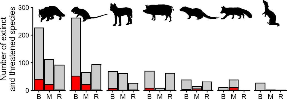
Similarly, there is little disagreement that cats hunt; for centuries humans have used them for rodent control. But invasive rats, which are often the target of modern rodent control, can grow too large to be easy prey for cats. In response, cats also pursue smaller species that are easier to catch. Studies have linked cats to 63 extinctions globally and estimated that cats kill 12.3 billion wild mammals annually in the U.S. alone.
Disagreements arise around handling cats that already live outside. Population management programs often utilize trap-neuter-return, or TNR – a process in which cats are trapped, spayed or neutered and re-released where they were caught.
In theory, TNR limits population growth by reducing the number of kittens that will be born. In reality it is rarely effective, since 75% of individual cats must be treated every year to reduce the population, which is often not feasible. Regardless, reproduction itself is not what most worries conservation biologists.
Feline invaders
Today the Earth is losing wild species at such a rate that many scientists believe it is experiencing its sixth mass extinction. In this context, free-roaming cats’ effects on wildlife are a serious concern. Cats have an instinctual drive to hunt, even if they are fed by humans. Many wildlife populations are already struggling to survive in a rapidly changing world. Falling prey to a non-native species doesn’t help.
Cats aren’t picky hunters but will pounce on the easiest available prey. This generalist predatory behavior contributes to their reputation as one of the most damaging invasive species. In our view, however, it could also be a key to limiting their ecological impact.
Managing cats based on their behavior
Since cats are generalist predators, their wild-caught diet tends to reflect the local species that are available. In areas with more birds than mammals, like New Zealand, birds are cats’ primary prey. Similarly, cat diets in the most developed portions of cities likely reflect the most available prey species – rats.
While cats top the list of harmful invasive species, rats aren’t far behind. In cities, rats spread disease, contaminate food and damage infrastructure. There aren’t many downsides to free-roaming cats preying on rats.
City centers have no shortage of rats, which can live anywhere, including parks, subways, sewers and buildings. But native animals tend to stay in or near areas with sufficient outdoor habitat, like parks and forested neighborhoods. When cats hunt in these same spaces, they are a threat to native wildlife. But if cats don’t share these spaces with native species, the risk declines dramatically.
Conservation funding is limited, so it’s critical to choose effective strategies. The traditional approach to cat management has largely consisted of attempting to prohibit cats from being loose altogether – an approach that’s incredibly unpopular with people who care for outdoor cats. Despite calls for outdoor cat bans, few have been enacted.
Instead, we suggest prioritizing areas where wildlife is most at risk. For example, cities could create “no cat zones” near urban habitats, which would forbid releasing trap-neuter-return cats in those areas and fine owners in those areas who let their cats roam outdoors.
In Washington, D.C., this would include forested neighborhoods like Palisades or Buena Vista, as well as homes near parks like Rock Creek. As we see it, this targeted approach would have more impact than citywide outdoor cat bans that are unpopular and difficult to enforce.
Hard-line policies have done little to reduce outdoor cat populations across the U.S. Instead, we believe a data-driven and targeted approach to cat management is a more effective way to protect wildlife.
[Understand new developments in science, health and technology, each week. Subscribe to The Conversation’s science newsletter.]![]()
Daniel Herrera, PhD Student in Environmental Science and Policy, George Mason University and Travis Gallo, Assistant Professor of Urban Wildlife Ecology and Conservation, George Mason University
This article is republished from The Conversation under a Creative Commons license. Read the original article.
- Details
- Written by: NATIONAL AERONAUTICS AND SPACE ADMINISTRATION

NASA’s Curiosity Mars rover spent most of March climbing the “Greenheugh Pediment” — a gentle slope capped by rubbly sandstone.
The rover briefly summited this feature’s north face two years ago; now on the pediment’s southern side, Curiosity has navigated back onto the pediment to explore it more fully.
But on March 18, the mission team saw an unexpected terrain change ahead and realized they would have to turn around: The path before Curiosity was carpeted with more wind-sharpened rocks, or ventifacts, than they have ever seen in the rover’s nearly 10 years on the Red Planet.
Ventifacts chewed up Curiosity’s wheels earlier in the mission. Since then, rover engineers have found ways to slow wheel wear, including a traction control algorithm, to reduce how frequently they need to assess the wheels. And they also plan rover routes that avoid driving over such rocks, including these latest ventifacts, which are made of sandstone – the hardest type of rock Curiosity has encountered on Mars.
The team nicknamed their scalelike appearance “gator-back” terrain. Although the mission had scouted the area using orbital imagery, it took seeing these rocks close-up to reveal the ventifacts.
“It was obvious from Curiosity’s photos that this would not be good for our wheels,” said Curiosity Project Manager Megan Lin of NASA’s Jet Propulsion Laboratory in Southern California, which leads the mission. “It would be slow going, and we wouldn’t have been able to implement rover-driving best practices.”
The gator-back rocks aren’t impassable – they just wouldn’t have been worth crossing, considering how difficult the path would be and how much they would age the rover’s wheels.
So the mission is mapping out a new course for the rover as it continues to explore Mount Sharp, a 3.4-mile-tall (5.5-kilometer-tall) mountain that Curiosity has been ascending since 2014.
As it climbs, Curiosity is able to study different sedimentary layers that were shaped by water billions of years ago. These layers help scientists understand whether microscopic life could have survived in the ancient Martian environment.
Why Greenheugh?
The Greenheugh Pediment is a broad, sloping plain near the base of Mount Sharp that extends about 1.2 miles (2 kilometers) across. Curiosity’s scientists first noticed it in orbital imagery before the rover’s landing in 2012. The pediment sticks out as a standalone feature on this part of Mount Sharp, and scientists wanted to understand how it formed.
It also sits nearby the Gediz Vallis Ridge, which may have been created as debris flowed down the mountain. Curiosity will always remain in the lower foothills of Mount Sharp, where there’s evidence of ancient water and environments that would have been habitable in the past. Driving across about a mile (1.5 kilometers) of the pediment to gather images of Gediz Vallis Ridge would have been a way to study material from the mountain’s uppermost reaches.
“From a distance, we can see car-sized boulders that were transported down from higher levels of Mount Sharp – maybe by water relatively late in Mars’ wet era,” said Ashwin Vasavada, Curiosity’s project scientist at JPL. “We don’t really know what they are, so we wanted to see them up close.”
The road less traveled
Over the next couple weeks, Curiosity will climb down from the pediment to a place it had previously been exploring: a transition zone between a clay-rich area and one with larger amounts of salt minerals called sulfates.
The clay minerals formed when the mountain was wetter, dappled with streams and ponds; the salts may have formed as Mars’ climate dried out over time.
“It was really cool to see rocks that preserved a time when lakes were drying up and being replaced by streams and dry sand dunes,” said Abigail Fraeman, Curiosity’s deputy project scientist at JPL. “I’m really curious to see what we find as we continue to climb on this alternate route.”
Curiosity’s wheels will be on safer ground as it leaves the gator-back terrain behind, but engineers are focused on other signs of wear on the rover’s robotic arm, which carries its rock drill. Braking mechanisms on two of the arm’s joints have stopped working in the past year.
However, each joint has redundant parts to ensure the arm can keep drilling rock samples. The team is studying the best ways to use the arm to ensure these redundant parts keep working as long as possible.
For more information about Curiosity, visit https://mars.nasa.gov/msl/home/ and https://nasa.gov/curiosity.

- Details
- Written by: Elizabeth Larson
The California Highway Patrol said the solo motorcycle crash was first reported at about 2:20 p.m. Saturday just west of Bruner Drive, between Lucerne and Glenhaven.
The motorcycle went into the lake and was reported to be about 20 feet off the shore. The rider was reported to be out of the water and on the lakeshore, according to radio traffic.
Firefighters responding to the scene reported a fatality, which the CHP confirmed a short time later.
Work took place at the scene to recover the motorcycle from the lake, the CHP reported.
The CHP said the highway remained open during the recovery.
Additional information on the circumstances of the crash were not immediately available.
Saturday’s fatal crash follows two deadly head-on wrecks earlier in the week, one on Wednesday near Blue Lakes and another on Friday near Middletown.
Email Elizabeth Larson at
- Details
- Written by: Elizabeth Larson
The wreck was first reported shortly before 5:20 p.m. on Highway 29 just south of Grange Road, north of Middletown and near the Crazy Creek gliderport.
The California Highway Patrol said two sedans — one black, one white — were involved.
Shortly after firefighters arrived on scene, they reported over the radio that one person had died, with another patient suffering minor injuries.
The highway remained open but the CHP warned of potential delays.
Additional information about the crash and its cause was not immediately available.
The wreck was the second fatal crash in Lake County this week.
On Wednesday, a crash near Blue Lakes on Highway 20 killed a Lakeport man, as Lake County News has reported.
Email Elizabeth Larson at