 How to resolve AdBlock issue?
News
- Details
- Written by: Elizabeth Larson
State Climatologist Dr. Michael Anderson said the seventh atmospheric river since Christmas made its way over California on Wednesday, dropping more heavy rain of about 1.5 inches.
The forecast showed that the storm is expected to continue to bring rain until Saturday.
The rain of the past several weeks is continuing to help Clear Lake recover from its lowest levels since the 1970s.
The United States Geological Survey’s gauge on Clear Lake showed its level was at 1.7 feet Rumsey, the special measure for the lake, late Wednesday night. The lake was at -2.4 just before Christmas.
Anderson said river systems are continuing to fluctuate after every storm, with water levels rising but not coming down as much after the storms pass.
“The hydrologic conditions will continue to evolve, particularly in our larger rivers, even as the storms abate,” Andersonsaid.
He said atmospheric river No. 7 is fitting climatologically with the level of rain the state’s water system can manage.
Heading into the weekend, Anderson said storm No. 8 will have a broader statewide area for precipitation, with rainfall forecast from the Oregon border to San Diego.
There will be a heavier accumulation of 1 to 3 inches in mountainous areas along the coast as well as the Sierra Nevada, Anderson said.
Anderson said storm No. 9, expected from Jan. 18 to 19, looks to be more focused in the Northern Sierra and north of the Golden Gate region.
The freezing elevation is expected to be in the 4,000 to 6,000 foot range, which Anderson said is good news — it means that the storm is likely to build more snow.
After Jan. 20, the state should get a break from the rain, although Anderson said the forecast models are showing the potential for another storm system to come in around Jan. 27.
Anderson said California is looking to be in a better situation than last year, when rain shut off for three months.
“The Sierra Nevada has had a lot of precipitation” and is accumulating a lot of snow, Anderson said.
As of Wednesday, Anderson said the state’s automated sensors registered what is considered a full seasonal snowpack, which usually takes place around April 1.
The last really big snowpack was in 2019, which Anderson said was the fifth largest going back to the beginning of snowpack monitoring in 1950. Other large snowpacks in recent years were in 2005, 2006, 2011 and 2017.
He said officials will revisit some flood management concerns as the snow melts, especially if it’s too quickly.
For water storage statewide, “We’ve seen some really impressive gains in our reservoir storage,” Anderson said.
Smaller facilities have recovered depleted storage and hit the top of their conservation marks for winter and are now pivoting into flood management operations, where they hold excessive flows while the water moves through before letting it out. Anderson said those actions are coordinated with the U.S. Army Corps of Engineers.
Lake Shasta and Lake Oroville, the keystone projects for the Central Valley Project and State Water Project, respectively, have caught a lot of water, Anderson said.
While Shasta and Oroville still have a lot of room to go until they get back to average or top of conservation marks, Anderson said they are off of historic lows thanks to the storms.
Anderson said there are still areas where water storage is depleted, and challenges for the Colorado River system remain.
“There will be underlying components of drought that will linger even when this is all done,” he said.
Molly White, State Water Project water operations manager for the Department of Water Resources, said the overall storage level of California’s 154 reservoirs was at 84% of the historic average on Wednesday, up 3% from Tuesday.
Lake Shasta, which White said has had a “steep increase” in its storage over the past month, was at 1.9 million acre feet at that point, surpassing its level last year.
Lake Oroville was at 1.7 million acre feet on Wednesday, or 88% of its historical average, White said. The lake’s average this time of year is around 2 million acre feet.
Jeremy Arrich, manager of Water Resources’ Division of Flood Management, said that with more storms on the way, it’s necessary to keep paying attention to safety advice and emergency orders.
The California Nevada River Forecast Center showed that 22 river and water systems were above monitor stage and four were above flood stage as of Wednesday night.
Areas in flood stage continued to include the Russian River in Mendocino and Sonoma counties.
Arrich said Bear Creek in Merced County has experienced a flood of record this year.
Email Elizabeth Larson at
- Details
- Written by: Elizabeth Larson
The Lakeport City Council unanimously approved the new policy at its first meeting of the year on Tuesday, Jan. 3.
City Clerk/Administrative Services Director Kelly Buendia explained that, in the wake of the pandemic, the business landscape has changed with the onset of working from home, an opportunity adopted by a large number of both businesses and government agencies.
She and City Manager Kevin Ingram have been monitoring the practice, taking classes, looking at policies and talking to other cities to understand how it will impact Lakeport.
“We all came back to city hall and opened our offices much sooner” than some larger neighboring cities, she said.
Buendia said employees want the telecommuting policy, which offers a number of benefits — including increased productivity, overall happiness of certain employees, flexibility and the potential for reduced absenteeism.
Buendia said the city was directly impacted by the loss of two employees who were offered telecommuting opportunities with other agencies.
She emphasized that not every employee and every job is ideal for telecommuting, it isn’t an entitlement, and it has to be addressed by the department director and approved by the city manager.
Employees who want to participate would need to sign an agreement, Buendia said.
Councilwoman Kim Costa said she thought the issues with recruitment are very relevant, with many businesses and agencies going in the telecommuting direction. “It’s sort of a non option to say a hard no.”
Rather, Costa said it’s more of a question of how to do it. Costa said the policy is thoughtful and it’s important that the assessment of who can do it be consistent even though job assignments are different.
Councilman Kenny Parlet said he’s concerned about employees getting hurt at home if their workspaces are a “hodgepodge” with trip hazards and other dangers.
“Other than that, I think it’s a brilliant way to go. I think that it’s necessary,” he said.
Buendia said city staff will keep an eye on the policy, and can beef it up if necessary. She said they are going in with the mindset that it might need to be brought back and strengthened.
Councilman Michael Froio raised the issue about there being no break between work and home life for those taking advantage of telecommuting. He said it’s nice to come to a place where you work, then leave to go home.
Froio said his mind went to the same concern as Parlet’s regarding home office safety, adding that one questionable workers’ compensation claim could wipe out the whole program.
He said they are fortunate to have a city full of very dedicated workers, he’s appreciative of employees and wants to give them every chance possible. If this helps them be more productive and happier, “I’m for this.”
Ingram said the policy will require a work agreement with a workplace environment checklist, which employees must sign saying they will maintain their home work space.
He said staff would like to bring the policy back for occasional updates, adding that the city is already starting to feel the squeeze on the retention side because others are offering telecommuting.
Asked by Lake County News about how many staff have expressed interest in telecommuting, Buendia said they had one person in beta testing and that she didn’t foresee there being a lot more.
Ingram said the city probably has two to three staff who have expressed interest.
Costa, who works for the county of Lake, said some people want structure at the office and others thrive in working from home.
“It feels a little uncomfortable at first because it’s a little different,” she said of the practice.
Costa said she feels like she has more eyes on telecommuting staff even when they’re not in the office. “It’s an adventure that has a little bit of discomfort built into it.”
Parlet moved to approve the policy, which Costa seconded and the council approved 4-0, with Councilman Brandon Disney absent.
Email Elizabeth Larson at
- Details
- Written by: LAKE COUNTY NEWS REPORTS
The meeting will take place from 5:30 to 7 p.m. at the Habematolel community center, 9460 Main St. in Upper Lake.
Community members also can attend via Zoom. The link is here.
The meeting ID is 982 1265 6300, pass code is 988681. Dial by location: +1 669 900 6833.
Discussion items include the Upper Lake levees, code enforcement, fire preparedness, drought and “HAWK” crosswalks.
They also will talk about a letter to the Board of Supervisors for funding for audio and video for meetings, universal trash pickup and the bylaws subcommittee.
Everyone is welcome to attend.
WRTH council members include Chair Tim Chiara, records keeper Linda Alexander, and members Thomas Aceves, Dave Eby, Kathryn Parankema, Claudine Pedroncelli and Melinda Wright.
- Details
- Written by: Amir AghaKouchak, University of California, Irvine
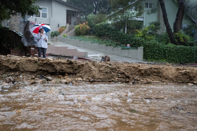
Rivers of muddy water from heavy rainfall raced through city streets as thousands of people evacuated homes downhill from California’s wildfire burn scars amid atmospheric river storms drenching the state in early January 2023.
The evacuations at one point included all of Montecito, home to around 8,000 people – and the site of the state’s deadliest mudslide on record exactly five years earlier.
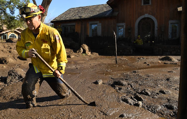
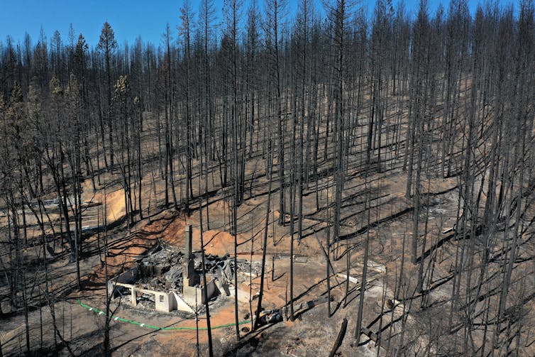
Wildfire burn scars are particularly risky because wildfires strip away vegetation and make the soil hydrophobic – meaning it is less able to absorb water. A downpour on these vulnerable landscapes can quickly erode the ground, and fast-moving water can carry the debris, rocks and mud with it.
With more storms expected through mid-January, officials warned of a risk of debris flows near several recently burned areas, including near Santa Barbara and Los Angeles, Monterey and Santa Cruz counties and the Shasta Trinity National Forest.
I study cascading hazards like this, in which consecutive events lead to human disasters. Studies show climate change is raising the risk of multiple compound disasters, including new research showing increasing risks to energy infrastructure.
When storms hit burn scars
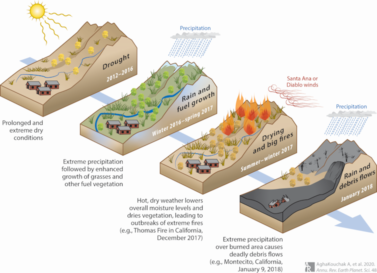
Five years ago, on Jan. 9, 2018, a deadly cascading disaster struck Montecito, a community in the coastal hills near Santa Barbara.
The cascade of events had started many months earlier with a drought, followed by a wet winter that fueled dense growth of vegetation and shrubs. An unusually warm and dry spring and summer followed, and it dried out the vegetation, turning it into fuel ready to burn. That fall, extreme Santa Ana and Diablo winds created the perfect conditions for wildfires.
The Thomas Fire began near Santa Barbara in December 2017 and burned over 280,000 acres. Then, on Jan. 9, 2018, extreme rainfall hit the region – including the burn scar left by the fire. Water raced through the burned landscape above Montecito, eroding the ground and creating the deadliest mudslide-debris flow event in California’s history. More than 400 homes were destroyed in about two hours, and 23 people died.
These kinds of cascading events aren’t unique to California. Australia’s Millennium Drought (1997-2009) also ended with devastating floods that inundated urban areas and breached levees. A study linked some of the levee and dike failures to earlier drought conditions, such as cracks forming because of exposure to heat and dryness.
Individually, they might not have been disasters
When multiple hazards such as droughts, heat waves, wildfires and extreme rainfall interact, human disasters often result.
The individual hazards might not be very extreme on their own, but combined they can become lethal. These types of events are broadly referred to as compound events. For example, a drought and heat wave might hit at the same time. A cascading event involves compound events in succession, like wildfires followed by downpours and mudslides.
With compound and cascading events likely to become more common in a warming world, the ability to prepare for and manage multiple hazards will be increasingly essential.
Climate change intensifies the risk
Several research studies have shown that compound events that include both drought and heat waves have become more severe and frequent in recent years. Studies have also shown that droughts and heat waves increase the likelihood of wildfires. And wildfires can also trigger other cascading hazards, turning otherwise unexceptional events into human disasters.
At the same time, extreme rainfall events are expected to intensify in a warming climate. A warmer atmosphere can hold more moisture, leading to wetter storms. This means more burned acres could be exposed to potentially extreme rainfall events in a warmer world.
Cascading hazards are not limited to rain over burned areas. For example, soot and ash deposits on snowpack can increase snowmelt, change the timing of runoff and cause snow-driven flooding.
It’s also important to recognize that human activities and local infrastructure can affect extreme events. Urbanization and deforestation, for example, can intensify flooding and worsen mud or debris flow events and their impacts. That was evident in the videos of muddy water pouring through streets in Santa Barbara County on Jan. 9, 2023.
In a recent study, colleagues and I also looked at the risks to energy infrastructure from cascading disasters involving intense rain over burn areas, focusing on natural gas pipelines and other infrastructure. Our results showed that not only will natural gas infrastructure be increasingly exposed to individual hazards, creating the potential for fires, the chances of cascading hazards are expected to increase substantially in a warming climate.
Managing multiple disasters and climate change
About a year after the devastating Montecito mudslide in 2018, I visited a location where damage to a natural gas pipeline hit by the mudslide led to a fire that burned multiple homes. Looking upstream, I could see many hills next to one another with similar burned scars, slopes and vegetation cover. Each one can be the ground zero for the next human disaster.
\Despite the high risk when extreme rainfall and droughts interact, most research in this area focuses on only rainfall or drought, but not both. Different government agencies oversee flood and drought monitoring, warning and management, even though both are extremes of the same hydrological cycle.
Recent disasters and research show a strong need to integrate management and risk reduction strategies of droughts and flood. Having one agency focus on one hazard can have unintended consequences for another hazard. For example, maximizing reservoir storage when expecting a drought can increase the flood risk.
Emergency response has improved since the 2018 Montecito disaster, but it’s clear that communities and government agencies still aren’t fully prepared for the scale and potential impacts of future events.
This article was updated Jan. 10 with the Montecito evacuation lifted. The article is an update to a version published Oct. 24, 2021.![]()
Amir AghaKouchak, Professor of Civil & Environmental Engineering and Earth System Science, University of California, Irvine
This article is republished from The Conversation under a Creative Commons license. Read the original article.