How to resolve AdBlock issue?
Refresh this page
How to resolve AdBlock issue?
Refresh this page
Lake County News,California
  • Home
    • Registration Form
  • News
    • Education
    • Veterans
    • Community
      • Obituaries
      • Letters
      • Commentary
    • Police Logs
    • Business
    • Recreation
    • Health
    • Religion
    • Legals
    • Arts & Life
    • Regional
  • Calendar
  • Contact us
    • FAQs
    • Phones, E-Mail
    • Subscribe
  • Advertise Here
  • Login
How to resolve AdBlock issue?
Refresh this page

News

Offensive names dot the American street map − a new app provides a way to track them

Details
Written by: Derek H. Alderman, University of Tennessee; Daniel Oto-Peralías, Universidad Pablo de Olavide, and Joshua F.J. Inwood, Penn State
Published: 18 August 2024


Clear County, Colo., had three roads using the word ‘sq—’ until May 2024, when officials renamed them. Tom Hellauer/Denver Gazette

The racially motivated tragedy in Charleston, South Carolina, in 2015, when a white supremacist murdered nine Black worshippers, and the deadly white nationalist rally in Charlottesville, Virginia, two years later compelled Americans to confront the role played by memorials, monuments and other symbols in glorifying racist ideologies.

George Floyd’s murder at the hands of a white Minneapolis police officer in 2020 only lent urgency to that challenge.

Part of the racial reckoning in the wake of Floyd’s death is a movement to remove offensive names from public places. Some names perpetuate demeaning slurs and stereotypes against people of color. Others honor historical figures linked to racism and colonization. This movement is what we geographers call America’s “renaming moment.”

Government officials, activists and other people have called for a renaming of certain places and institutions. Examples include removing Christopher Columbus’ name from a Chicago public school and erasing the name of former KKK leader and governor Bibb Graves from a University of Alabama building. The elimination of names of Confederate generals from several U.S. military bases provides another example.

These changes have become flash points of community activism and debate, both in support of and in resistance to name revisions.

A widespread element in this renaming moment are offensive street names. We believe discussions and decisions about removing these names may benefit from comprehensive sources of information that allow the public to know how pervasive a problem the country might be confronting.

The recent release of an app developed by STNAMES LAB, an international team of scholars of place names, allows users to conduct nationwide inventories of discriminatory roadway names, revealing how often and where they are found.

We believe the app is an important educational tool. It will help communities understand how discriminatory beliefs are woven into everyday spaces and the harm caused by offensive names.

After tracking a few of America’s most contested place and institution names, we believe the app will help people see the changes necessary to recognize and repair past wrongs in street naming.

Recognizing that names can harm and heal

There is growing public recognition that place names are not neutral identifiers of locations. Rather, place names can transmit harmful messages that misrepresent the history and identity of minority communities. As a result, they work against the possibility of a more equal society.

One highly publicized effort at identifying and replacing offensive place names happened in November 2021.

U.S. Interior Secretary Deb Haaland, the first Native American to hold that post, ordered the removal of the word “squaw,” hereafter called “sq—,” from the names of 650 mountains, rivers and other sites on federal lands. Haaland’s order capped many years of demands from Native American groups to eradicate the racist and sexist label.

Then, in 2022, Haaland established the Advisory Committee on Reconciliation in Place Names, comprising members from tribal nations, Native Hawaiian organizations and scholars. Its guiding principles call on the U.S. to recognize the historical role of racism and sexism in naming places. They also highlight how those in power have used names to disrespect, misrepresent and control certain groups that have been historically discriminated against.

Drawing from public comments over two years, the committee found that derogatory place names are a source of recurring trauma for groups that have been historically discriminated against. As one Native American community leader told the committee, “Names matter, as they can build or break a relationship with the land and have the power to uplift or marginalize communities.”

Similarly, a 2022 report by the National Association of Tribal Historic Preservation Officers and the Wilderness Society found derogatory place names can create an unwelcoming environment that some people avoid. Additionally, a 2022 study by Emory University found that homes on streets named for pro-slavery Confederate figures sell for less and take longer to sell than comparable houses on nearby roads.

Renaming roads serves as an important moment of community reconciliation. That’s because the frequent use of offensive street names exacts a hefty social and psychological toll on marginalized communities, according to the cultural historian Deirdre Mask.

When hurtful names are removed from roads, some members of oppressed communities describe how the spirit or feeling of places can change and allow healing to begin.

The difference an audit makes

The Interior Department committee suggests that efforts to change offensive names should be driven by research. It encourages local residents to identify where derogatory place names exist, when and how they were named, and how those names can harm the well-being of community members.

Data scientist Catherine D’Ignazio and her team at the Data + Feminism Lab agree. They call for conducting audits that collect and visualize data on unjust names, to challenge the damaging effects and abuses of power behind these symbols.

The newly released street names app from STNAMES LAB allows people to do that. Fed with Open Street Map data, it lets users carry out queries, as well as map and download streets containing certain terms.

Once users enter a name, they can check the specific location of named roads on a map. They can also download query results as a spreadsheet to get the full list of streets.

The app offers an easy visualization of the frequency and geographic distribution of names. You can see whether the name is found across the nation or concentrated in a specific region.

Demonstrating the app

To illustrate the app’s capabilities, we searched for names that have sparked public controversy.

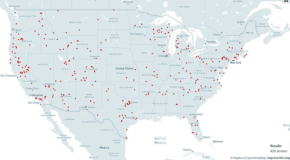
Federal condemnation of “sq—” as a place name does not mean that local authorities will follow suit, even if some cities and states are already doing so. We found 429 streets scattered across 47 states with a name containing the word “sq—.”

Although “sq—” originated in the Algonquian language, European settlers corrupted and misused the word in reducing Native American women to a simplistic and sexualized image. Being called “sq—” is still a painful daily reality for Indigenous women. Many of them say the term injures their self-image and sense of belonging.

Map of offensive street names in the U.S.
Map of U.S. roads named ‘sq—’ from the street names app. https://en.stnameslab.com/the-project/

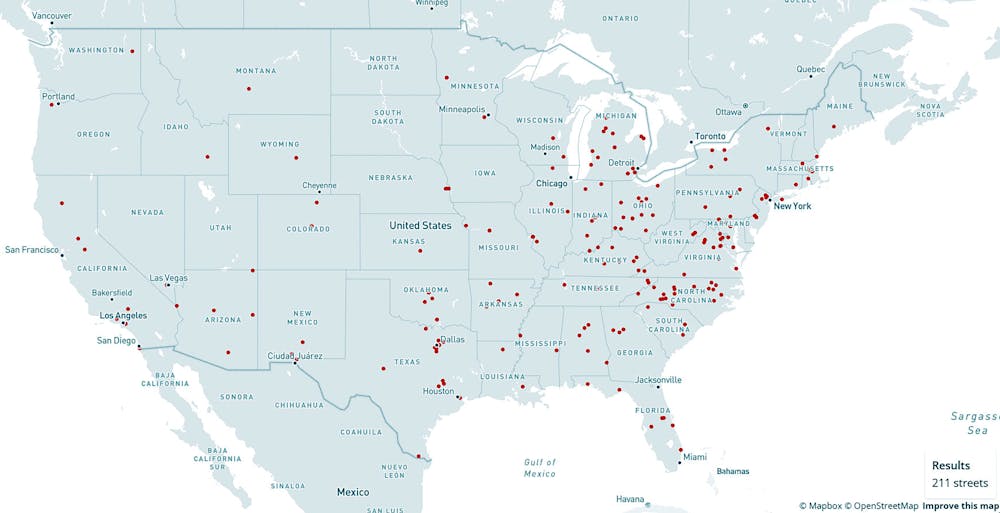
The street name app exposes other racist Native American stereotypes. Variations of “redman/men” and “redskin” appear on 211 roads.

“Redskin” is a portrayal of Native Americans as warlike and dangerous. According to Native writer Angelina Newsome, colonialists often used it interchangeably with “savage.”

We found 415 roads in 46 states using the word “savage” in their name.

Though references to “redman” and “redskin” have long shown up in consumer products and sports team mascots, many Native groups challenge these stereotypes as demeaning.

Map of offensive street signs in U.S.
Map of roads named ‘redman,’ ‘redmen’ or ‘redskin’ from the street names app. https://en.stnameslab.com/the-project/

Searching for offensive street names across the country is about more than simply collecting information. Data and maps can be part of the process of expanding one’s sphere of awareness and caring for people living with unjust naming practices.

Tracking and visualizing these inequalities is key to developing the “civic imagination” that scholar Catherine D'Ignazio believes is necessary to imagine and call for more inclusive alternatives to the current American landscape of names.

What is at stake is not just removing insulting names in and of themselves, but ensuring that the places marked by these names feel more welcoming and respectful of all Americans.The Conversation

Derek H. Alderman, Professor of Geography, University of Tennessee; Daniel Oto-Peralías, Associate Professor of Economics, Profesor Titular de Economía, Universidad Pablo de Olavide, and Joshua F.J. Inwood, Professor of Geography and Senior Research Associate in the Rock Ethics Institute, Penn State

This article is republished from The Conversation under a Creative Commons license. Read the original article.

Helping Paws: More puppies and shepherds

Details
Written by: Elizabeth Larson
Published: 18 August 2024
LAKE COUNTY, Calif. — Lake County Animal Care and Control has a lot of puppies, shepherds and working dogs ready to go to new homes.

Dogs available for adoption this week include mixes of Australian shepherd, border collie, German shepherd, Labrador Retriever, pit bull terrier, Rottweiler and terrier.

Dogs that are adopted from Lake County Animal Care and Control are either neutered or spayed, microchipped and, if old enough, given a rabies shot and county license before being released to their new owner. License fees do not apply to residents of the cities of Lakeport or Clearlake.

Those dogs and the others shown on this page at the Lake County Animal Care and Control shelter have been cleared for adoption.

Call Lake County Animal Care and Control at 707-263-0278 or visit the shelter online for information on visiting or adopting.

The shelter is located at 4949 Helbush in Lakeport.

Email Elizabeth Larson at This email address is being protected from spambots. You need JavaScript enabled to view it.. Follow her on Twitter, @ERLarson, or Lake County News, @LakeCoNews.


Kennel#17's preview photo
Kennel#17

Kennel#9's preview photo
Kennel#9

Kennel#6's preview photo
Kennel#6

Kennel#29a's preview photo
Kennel#29a

Kennel#29b's preview photo
Kennel#29b

Kennel#30's preview photo
Kennel#30

Kennel#28a's preview photo
Kennel#28a

Kennel#28b's preview photo
Kennel#28b

Kennel#25a(RedCollar)'s preview photo
Kennel#25a(RedCollar)

Kennel#25b(YellowCollar)'s preview photo
Kennel#25b(YellowCollar)

Kennel#25c(GreenCollar)'s preview photo
Kennel#25c(GreenCollar)

Kennel#25d(PinkCollar)'s preview photo
Kennel#25d(PinkCollar)

Kennel#24c(BlueCollar)'s preview photo
Kennel#24c(BlueCollar)

Kennel#24a(YellowCollar)'s preview photo
Kennel#24a(YellowCollar)

Kennel#24b(PinkCollar)'s preview photo
Kennel#24b(PinkCollar)


Kennel#34's preview photo
Kennel#34

Kennel#31's preview photo
Kennel#31

Kennel#21's preview photo
Kennel#21

Kennel#8's preview photo
Kennel#8

Kennel#11a(pink collar)'s preview photo
Kennel#11a(pink collar)

Kennel#11b(blue collar)'s preview photo
Kennel#11b(blue collar)

Kennel#4's preview photo
Kennel#4

Kennel#20's preview photo
Kennel#20

Kennel#26(Pickle)'s preview photo
Kennel#26(Pickle)

Kennel#2b's preview photo
Kennel#2b

Kennel#27's preview photo
Kennel#27

Kennel#14's preview photo
Kennel#14

Kennel#5(Fidgit)'s preview photo
Kennel#5(Fidgit)


Kennel#19a's preview photo
Kennel#19a

Kennel#19b's preview photo
Kennel#19b

Kennel#12's preview photo
Kennel#12


Kennel#10(Akeyla)'s preview photo
Kennel#10(Akeyla)


Banana apocalypse, part 2 – a genomicist explains the tricky genetics of the fungus devastating bananas worldwide

Details
Written by: Li-Jun Ma, UMass Amherst
Published: 18 August 2024


Fusarium oxysporum spores can remain hardy in soil for decades. Andrii Volosheniuk/iStock via Getty Images Plus

Did you know that the bananas you eat today are not the same type as the ones people were eating a few generations ago? The banana you might have had with your breakfast today is a variety called the Cavendish banana, while the one that was in grocery stores up to the 1950s was a variety called Gros Michel, which was wiped out by a disease called Fusarium wilt of banana, or FWB.

FWB of Gros Michel was caused by Fusarium oxysporum race 1, a fungal pathogen that affects bananas. This fungal infection kills a plant by occupying its vascular system, blocking water and mineral transportation.

Hang holding a bunch of relatively short and thick bananas
You would be hard-pressed to find a Gros Michel banana in American supermarkets today. krares/iStock via Getty Images Plus

Plant biologists developed the Fusarium-resistant Cavendish variety to replace the Gros Michel. Yet, over the past few decades, a resurgence of FWB caused by a different strain of the same fungus called tropical race 4, or TR4, is once again threatening global banana production.

How did Fusarium oxysporum gain the ability to overcome resistance and infect so many different plants?

The two-part genome of F. oxysporum

I am a genomicist who has spent the past decade studying the genetic evolution of Fusarium oxysporum. As a species complex, F. oxysporum can cause wilt and root rot diseases in over 120 plant species. Certain strains can also infect people.

In 2010, my lab discovered that each F. oxysporum genome can be divided into two parts: a core genome shared among all strains that codes for essential housekeeping functions, and an accessory genome varying from strain to strain that codes for specialized functions like the ability to infect a specific plant host.

Each species of plant has a sophisticated immune response to defend against microbial invasion. So to establish an infection, each F. oxysporum strain uses its accessory genome to suppress a plant’s unique defense system. This functional compartmentalization allows F. oxysporum to greatly increase its host range.

Petri dish with four red, oblong colonies crowing on separate corners
The genomic structure of Fusarium oxysporum allows it to have a wide range of hosts, such as tomatoes, cucumbers and watermelon. Edward L. Barnard, Florida Department of Agriculture and Consumer Services, Bugwood.org, CC BY-SA

In our newly published research, my team and colleagues in China and South Africa found that the TR4 strain that kills Cavendish bananas has a different evolutionary origin and different sequences in its accessory genome compared with the strain that killed Gros Michel bananas.

Looking at the interface of where the TR4 strain is battling with its Cavendish banana host, we found that some of its activated accessory genes release nitric oxide, a gas harmful to the Cavendish banana. This sudden burst of toxic gases facilitates infection by disarming the plant’s defense system. At the same time, the fungus protects itself by increasing production of chemicals that detoxify nitric oxide.

Increasing banana diversity

In tracing the global spread of this new version of Fusarium oxysporum, we realized that a major cause for the recent resurgence of this fungal infection is the domination of the international banana industry by a single clone of banana.

Growing different varieties of bananas can make agriculture more sustainable and reduce disease pressure on a single crop. Farmers and researchers can control Fusarium wilt of banana by identifying or developing banana varieties that are tolerant or resistant to TR4. Our findings suggest that another way to protect Cavendish bananas would be to design effective nitric oxide scavengers to reduce the toxic pressure of the gas burst.

The banana industry has dark origins.

It can be hard to imagine how a consumer who simply enjoys eating bananas could participate in the battle against the disease devastating banana crops. However, consumers determine the market, and farmers are forced to grow what the market demands.

You can help increase banana diversity in your supermarket by intentionally trying one or more of the other hundreds of other existing banana varieties when they show up there. You can also buy local varieties of other fruits and agricultural products to help preserve plant diversity and support local growers.

Collaboration among scientists, farmers, industry and consumers around the world can help avoid future shortages of bananas and other crops.The Conversation

Li-Jun Ma, Professor of Biochemistry and Molecular Biology, UMass Amherst

This article is republished from The Conversation under a Creative Commons license. Read the original article.

Space News: Scientists find oceans of water on Mars

Details
Written by: Robert Sanders
Published: 18 August 2024
A 2018 photo of Mars during a dust storm, snapped by the Hubble Space Telescope. More than 3 billion years ago, the dusty red planet had oceans and rivers. That water disappeared, leaving only ice on the surface, most of it in the polar caps. A new analysis of Mars' interior suggests that much of the liquid water still exists in the pores of rocks 10-20 kilometers below the surface. Photo credit: NASA, ESA, STScI.

Seismic data from the Insight lander indicate deep, porous rock filled with liquid water.

BERKELEY, Calif. — Using seismic activity to probe the interior of Mars, geophysicists have found evidence for a large underground reservoir of liquid water — enough to fill oceans on the planet's surface.

The data from NASA's Insight lander allowed the scientists to estimate that the amount of groundwater could cover the entire planet to a depth of between 1 and 2 kilometers, or about a mile.

While that’s good news for those tracking the fate of water on the planet after its oceans disappeared more than 3 billion years ago, the reservoir won't be of much use to anyone trying to tap into it to supply a future Mars colony. It's located in tiny cracks and pores in rock in the middle of the Martian crust, between 11.5 and 20 kilometers (7 to 13 miles) below the surface. Even on Earth, drilling a hole a kilometer deep is a challenge.

The finding does pinpoint another promising place to look for life on Mars, however, if the reservoir can be accessed. For the moment, it helps answer questions about the geological history of the planet.

“Understanding the Martian water cycle is critical for understanding the evolution of the climate, surface and interior,” said Vashan Wright, a former UC Berkeley postdoctoral fellow who is now an assistant professor at UC San Diego’s Scripps Institution of Oceanography. “A useful starting point is to identify where water is and how much is there.”

Wright, alongside colleagues Michael Manga of UC Berkeley and Matthias Morzfeld of Scripps Oceanography, detailed their analysis in a paper that will appear this week in the journal Proceedings of the National Academy of Sciences.

The scientists employed a mathematical model of rock physics, identical to models used on Earth to map underground aquifers and oil fields, to conclude that the seismic data from Insight are best explained by a deep layer of fractured igneous rock saturated with liquid water. Igneous rocks are cooled hot magma, like the granite of the Sierra Nevada.

"Establishing that there is a big reservoir of liquid water provides some window into what the climate was like or could be like," said Manga, a UC Berkeley professor of earth and planetary science. "And water is necessary for life as we know it. I don't see why [the underground reservoir] is not a habitable environment. It's certainly true on Earth — deep, deep mines host life, the bottom of the ocean hosts life. We haven't found any evidence for life on Mars, but at least we have identified a place that should, in principle, be able to sustain life."

Manga was Wright's postdoctoral adviser. Morzfeld was a former postdoctoral fellow in UC Berkeley’s mathematics department and is now an associate professor of geophysics at Scripps Oceanography.

Manga noted that lots of evidence — river channels, deltas and lake deposits, as well as water-altered rock — supports the hypothesis that water once flowed on the planet's surface. But that wet period ended more than 3 billion years ago, after Mars lost its atmosphere. Planetary scientists on Earth have sent many probes and landers to the planet to find out what happened to that water — the water frozen in Mars' polar ice caps can't account for it all — as well as when it happened, and whether life exists or used to exist on the planet.

The new findings are an indication that much of the water did not escape into space but filtered down into the crust.

The Insight lander was sent by NASA to Mars in 2018 to investigate the crust, mantle, core and atmosphere, and it recorded invaluable information about Mars' interior before the mission ended in 2022.

"The mission greatly exceeded my expectations," Manga said. "From looking at all the seismic data that Insight collected, they've figured out the thickness of the crust, the depth of the core, the composition of the core, even a little bit about the temperature within the mantle."

Insight detected Mars quakes up to about a magnitude of 5, meteor impacts and rumblings from volcanic areas, all of which produced seismic waves that allowed geophysicists to probe the interior.

An earlier paper reported that above a depth of about 5 kilometers, the upper crust did not contain water ice, as Manga and others suspected. That may mean that there's little accessible frozen groundwater outside the polar regions.

The new paper analyzed the deeper crust and concluded that the "available data are best explained by a water-saturated mid-crust" below Insight’s location. Assuming the crust is similar throughout the planet, the team argued, there should be more water in this mid-crust zone than the "volumes proposed to have filled hypothesized ancient Martian oceans."

The Canadian Institute for Advanced Research, the National Science Foundation and the U.S. Office of Naval Research supported the work.

Robert Sanders writes for the UC Berkeley News Center.
  1. Governor signs bills cracking down on retail crime and property theft; benefits may be limited for rural areas
  2. Local elections are less partisan because voters will cross party lines when issues hit close to home
  3. Clearlake Animal Control: Available puppies
  • 577
  • 578
  • 579
  • 580
  • 581
  • 582
  • 583
  • 584
  • 585
  • 586
How to resolve AdBlock issue?
Refresh this page