How to resolve AdBlock issue?
Refresh this page
How to resolve AdBlock issue?
Refresh this page
Lake County News,California
  • Home
    • Registration Form
  • News
    • Education
    • Veterans
    • Community
      • Obituaries
      • Letters
      • Commentary
    • Police Logs
    • Business
    • Recreation
    • Health
    • Religion
    • Legals
    • Arts & Life
    • Regional
  • Calendar
  • Contact us
    • FAQs
    • Phones, E-Mail
    • Subscribe
  • Advertise Here
  • Login
How to resolve AdBlock issue?
Refresh this page

News

Department of Interior approves Scotts Valley Pomo’s Vallejo casino project over other tribes’ objections

Details
Written by: Elizabeth Larson
Published: 11 January 2025
NORTHERN CALIFORNIA — Over the objections of other tribes as well as California’s governor, the Department of Interior on Friday approved the Scotts Valley Pomo’s plan for a mega casino in Vallejo, far from its traditional lands and on land sacred to the Patwin people.

The Scotts Valley Band of Pomo Indians, based in Lakeport, has faced strong opposition for years to its plan to build a 400,000 square foot, $700 million casino complex near I-80 and Highway 37 on a 128-acre site.

The development also is planned to include 24 homes and an administrative building to be “the nerve center for tribal governance,” Scotts Valley Tribal Chair Shawn Davis said during a July hearing.

The location was meant for open space and contains cultural sites sacred to the Yocha Dehe Wintun Nation, which on Friday issued a statement condemning the decision, which it said will lead to desecration of its homelands.

“For months, the Department of the Interior worked in secret to move the controversial project forward, undermining public notice, tribal consultation, and environmental review requirements along the way,” the Yocha Dehe said in its statement. “In fact, despite being informed multiple times, by both Tribes and the State Historic Preservation Officer, that the required and important National Historic Preservation Act Section 106 consultation process had not been completed, the Department knowingly and intentionally proceeded in violation of this bedrock law.”

The Yocha Dehe said the location is 100 miles away from Scotts Valley’s homelands, but at the core of its Patwin ancestral territory in Vallejo.

“We are deeply disappointed and disheartened to see this decision from the Biden Administration. It is difficult to believe that a group of politicians who claim to care about respecting tribal rights and sovereignty would give away historic Patwin homelands without ever consulting us. The hypocrisy is staggering,” said Yocha Dehe Chairman Anthony Roberts.

U.S. Senator Alex Padilla, U.S. Representatives John Garamendi (D-CA-08) and Mike Thompson (D-CA-04) oppose the project, as do a large number of Yolo County government officials and advocacy groups, and thousands of concerned citizens.

A common argument against the project has been Scotts Valley’s lack of historical connection to Vallejo.

The Yocha Dehe also pointed out that, on three separate occasions, the Department of the Interior has determined that Scotts Valley lacks the significant historical connection to the Bay Area needed to acquire land eligible for gaming.

However, it was a 2022 U.S. District Court for the District of Columbia ruling that put the case back with the Department of the Interior.

Since then, opposing tribes have criticized the Department of the Interior for bypassing their concerns. They said the situation has resulted in a lack of transparency, fairness and government-to-government consultation requests.

The Department of Interior also has been criticized for failing to thoroughly evaluate the environmental and related social and economic effects of the project by conducting an environmental impact statement. Instead, the agency issued what opponents said was an “inadequate environmental assessment” that fails to meet federal environmental guidelines, and which has inaccurate and complete information, or is missing key elements.

Gov. Gavin Newsom is amongst those opposing the Scotts Valley plan, as well as that of another Lake County tribe — the Koi Nation — that wants to build a casino in Windsor, as Lake County News has reported.

Newsom also has come out against a plan for the first off-reservation casino in Oregon. The project, to be located in Medford, is proposed by the Coquille Indian Tribe, whose reservation is in North Bend, nearly 170 miles away from the site.

On Friday, the Department of Interior signed the record of decision approving the Coquille tribe’s casino plan.

The Cow Creek Band of Umpqua Tribe of Indians, Karuk Tribe and Tolowa Dee-ni' Nation in Oregon reported that they immediately filed a request Friday evening for the U.S. District Court to issue a temporary restraining order, citing violations of the Indian Gaming Regulatory Act, the Indian Reorganization Act and the Coquille Restoration Act, as well as constitutional concerns related to the National Environmental Policy Act.

“We were excited and hopeful when Secretary Haaland was appointed but her legacy is irreparably tarnished by this shameful, illegal decision,” Roberts said. “For Tribes like ours, nothing is more important than our ancestral homelands. To see our land and cultural resources taken away for the benefit of wealthy investors is painful beyond words. Throughout this process, we have been left in the dark, struggling to have our voices heard. We hope that the next Administration will take a different approach to consultation with Tribes, especially on matters that affect their ancestral homelands.”

Roberts said the matter isn’t settled yet for his tribe.

“The Department of the Interior violated their trust responsibilities for all Tribes with this unfair decision,” continued Chairman Roberts. “Although the project was approved, our fight is not over. The Yocha Dehe Wintun Nation will take every step necessary to continue fighting for our homelands and our future.”

Email Elizabeth Larson at This email address is being protected from spambots. You need JavaScript enabled to view it.. Follow her on Twitter, @ERLarson, and on Bluesky, @erlarson.bsky.social. Find Lake County News on the following platforms: Facebook, @LakeCoNews; X, @LakeCoNews; Threads, @lakeconews, and on Bluesky, @lakeconews.bsky.social.

City of Lakeport highlights food recovery efforts

Details
Written by: LAKE COUNTY NEWS REPORTS
Published: 11 January 2025
LAKEPORT, Calif. — California’s Senate Bill 1383 is changing the way communities manage food waste and support those in need.

The city of Lakeport reported on its efforts to meet SB 1383’s requirements.

City officials called SB 1383 “innovative legislation” that “is making a real difference in our community by reducing edible food waste and ensuring surplus food is redirected to individuals and families who need it most.”

In 2024, the three supermarkets in the city of Lakeport donated 187,534 pounds of food to the Clear Lake Gleaners Organization in Finley.

This donated food is then distributed by the Gleaners to individuals and families in need across Lake County, marking a significant win for both the community and the environment, city officials reported.

SB 1383 is legislation designed to reduce organic waste disposal by 75% and recover 20% of surplus edible food to feed those in need.

The law emphasizes collaboration between governments, businesses and residents to combat climate change, address food insecurity and create a sustainable future.

By participating in SB 1383, the city said it is reducing food waste and hunger, creating a sustainable food system and keeping organic waste out of the landfill.

The Clear Lake Gleaners will host their next USDA Food Distribution from 8 to 10 a.m. Thursday, Jan. 16.

Locations are:

Clearlake: The Crossroads Church, 6039 Crawford Ave.
Cobb: Cobb Mountain Lions, Little Red School House
Finley: Clear Lake Gleaners, 1896 Big Valley Road.
Middletown: Middletown Lions Club, 15399 Central Park Road.
Nice: 2817 Highway 20 (Cross street is Lakeview Drive)
Spring Valley: Community Center, 2975/3005 Wolf Creek Road.

Clearlake Animal Control: ‘Alaska’ and the dogs

Details
Written by: Elizabeth Larson
Published: 11 January 2025
"Alaska." Photo courtesy of Clearlake Animal Control.

CLEARLAKE, Calif. — Clearlake Animal Control has new young dogs waiting for new homes.

The shelter has 44 adoptable dogs listed on its website.

This week’s dogs include “Alaska,” a male Labrador retriever mix with a chocolate and white coat.

The shelter is located at 6820 Old Highway 53. It’s open from 9 a.m. to 6 p.m. Tuesday through Saturday.

For more information, call the shelter at 707-762-6227, email iThis email address is being protected from spambots. You need JavaScript enabled to view it., visit Clearlake Animal Control on Facebook or on the city’s website.

This week’s adoptable dogs are featured below.

Email Elizabeth Larson at This email address is being protected from spambots. You need JavaScript enabled to view it.. Follow her on Twitter, @ERLarson, and on Bluesky, @erlarson.bsky.social. Find Lake County News on the following platforms: Facebook, @LakeCoNews; X, @LakeCoNews; Threads, @lakeconews, and on Bluesky, @lakeconews.bsky.social.

How Santa Ana winds fueled the deadly fires in Southern California

Details
Written by: Jon Keeley, University of California, Los Angeles
Published: 11 January 2025


Over 1,000 structures burned in the span of two days, Jan 7-8, 2025, near Los Angeles. AP Photo/Ethan Swope

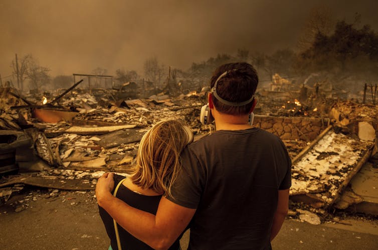
Powerful Santa Ana winds, with gusts reaching hurricane strength, swept down the mountains outside Los Angeles and spread wildfires into several neighborhoods starting Jan. 7, 2025, creating a terrifying scene.

Thousands of homes and other structures, including several schools, had burned by Jan. 9, and at least five people had died. Officials urged more than 180,000 residents to evacuate at the height of the fires. With the winds so strong, there was little firefighters could do to control the flames.

Jon Keeley, a research ecologist in California with the U.S. Geological Survey and adjunct professor at UCLA, explains what causes extreme winds like this in Southern California, and why they create such a dangerous fire risk.

What causes the Santa Ana winds?

The Santa Ana winds are dry, powerful winds that blow down the mountains toward the Southern California coast. The region sees about 10 Santa Ana wind events a year on average, typically occurring from fall into January.

When conditions are dry, as they are right now, these winds can become a severe fire hazard.

A map shows how the Santa Ana winds blow.
Santa Ana winds blow down the mountains toward the coast, drying and warming as they descend. USGS

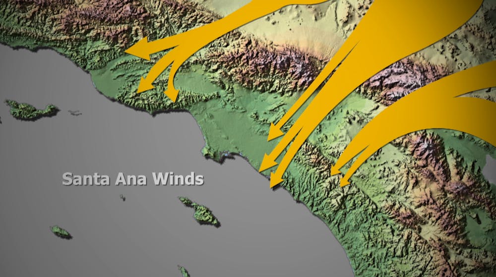
The Santa Ana winds occur when there is high pressure to the east, in the Great Basin, and a low-pressure system off the coast. Air masses move from high pressure to low pressure, and the more extreme the difference in the pressure, the faster the winds blow.

Topography also plays a role.

As the winds rush downslope from the top of the San Gabriel Mountains, they become drier and hotter. That’s a function of the physics of air masses. By the time the winds get to the point where the Eaton Fire broke out in Altadena on Jan. 7, it’s not uncommon for them to have less than 5% relative humidity, meaning essentially no moisture at all.

Canyons also channel the winds. I used to live in the Altadena area, and we would get days during Santa Ana wind events when the wind wasn’t present at all where we lived, but, a few blocks away, the wind was extremely strong.

These strong, dry winds are often around 30 to 40 mph. But they can be stronger. The wind gusts in early January 2025 were reported to have exceeded 80 mph.

Why was the fire risk so high this time?

Typically, Southern California has enough rain by now that the vegetation is moist and doesn’t readily burn. A study a few years ago showed that autumn moisture reduces the risk of Santa Ana wind-driven fires.

This year, however, Southern California has very dry conditions, with very little moisture over the past several months. With these extreme winds, we have the perfect storm for severe fires.

People sit on swings at the beach watching thick dark smoke over the city.
Dark smoke from the fires was evident from the Santa Monica, Calif., pier on Jan. 8, 2025. AP Photo/Richard Vogel

It’s very hard to extinguish a fire under these conditions. The firefighters in the area will tell you, if there’s a Santa Ana wind-driven fire, they will evacuate people ahead of the fire front and control the edges – but when the wind is blowing like this, there’s very little chance of stopping it until the wind subsides.

Other states have seen similar fires driven by strong downslope winds. During the Chimney Tops 2 Fire in Tennessee in November 2016, strong downslope winds spread the flames into homes in Gatlinburg, killing 14 people and burning more than 2,500 homes. Boulder County, Colorado, lost about 1,000 homes when powerful winds coming down the mountains there spread the Marshall Fire in December 2021.

Have the Santa Ana winds changed over time?

Santa Ana wind events aren’t new, but we’re seeing them more often this time of year.

My colleagues and I recently published a paper comparing 71 years of Santa Ana wind events, starting in 1948. We found about the same amount of overall Santa Ana wind activity, but the timing is shifting from fewer events in September and more in December and January. Due to well-documented trends in climate change, it is tempting to ascribe this to global warming, but as yet there is no substantial evidence of this.

California is seeing more destructive fires than we saw in the past. That’s driven not just by changes in the climate and the winds, but also by population growth.

More people now live in and at the edges of wildland areas, and the power grid has expanded with them. That creates more opportunities for fires to start. In extreme weather, power lines face a higher risk of falling or being hit by tree branches and sparking a fire. The area burnt because of fires related to power lines has greatly expanded; today it is the major ignition source for destructive fires in Southern California.

A fire truck sprays water from the street as homes burn on a hillside.
Firefighters work to extinguish burning homes in the Pacific Palisades neighborhood of Los Angeles on Jan. 8, 2025. AP Photo/Damian Dovarganes

The Eaton Fire, which has burned many homes, is at the upper perimeter of the San Gabriel Basin, at the base of the San Gabriel Mountains. Fifty years ago, fewer people lived there. Back then, some parts of the basin were surrounded by citrus orchards, and fires in the mountains would burn out in the orchards before reaching homes.

Today, there is no buffer between homes and the wildland. The point of ignition for the Eaton Fire appears to have been near or within one of those neighborhoods.

Homes are made of dried materials, and when the atmosphere is dry, they combust readily, allowing fires to spread quickly through neighborhoods and creating a great risk of destructive fires.

This article, originally published Jan. 8, has been updated with new details on the fires.The Conversation

Jon Keeley, Research Ecologist, USGS; Adjunct Professor, University of California, Los Angeles

This article is republished from The Conversation under a Creative Commons license. Read the original article.

  1. Space News: From new commercial Moon landers to asteroid investigations, expect a slate of exciting space missions in 2025
  2. Lake County’s agricultural production reaches record level in 2023
  3. Woodland Community College helped Reil create his path
  • 420
  • 421
  • 422
  • 423
  • 424
  • 425
  • 426
  • 427
  • 428
  • 429
How to resolve AdBlock issue?
Refresh this page