How to resolve AdBlock issue?
Refresh this page
How to resolve AdBlock issue?
Refresh this page
Lake County News,California
  • Home
    • Registration Form
  • News
    • Education
    • Veterans
    • Community
      • Obituaries
      • Letters
      • Commentary
    • Police Logs
    • Business
    • Recreation
    • Health
    • Religion
    • Legals
    • Arts & Life
    • Regional
  • Calendar
  • Contact us
    • FAQs
    • Phones, E-Mail
    • Subscribe
  • Advertise Here
  • Login
How to resolve AdBlock issue?
Refresh this page

News

What causes the powerful winds that fuel dust storms, wildfires and blizzards? A weather scientist explains

Details
Written by: Chris Nowotarski, Texas A&M University
Published: 10 April 2025


When huge dust storms like this one in the Phoenix suburbs in 2022 hit, it’s easy to see the power of the wind. Christopher Harris/iStock Images via Getty Plus

Windstorms can seem like they come out of nowhere, hitting with a sudden blast. They might be hundreds of miles long, stretching over several states, or just in your neighborhood.

But they all have one thing in common: a change in air pressure.

Just like air rushing out of your car tire when the valve is open, air in the atmosphere is forced from areas of high pressure to areas of low pressure.

The stronger the difference in pressure, the stronger the winds that will ultimately result.

A weather map with a line between high and low pressure stretching across the U.S.
On this forecast for March 18, 2025, from the National Oceanic and Atmospheric Administration, ‘L’ represents low-pressure systems. The shaded area over New Mexico and west Texas represents strong winds and low humidity that combine to raise the risk of wildfires. NOAA Weather Prediction Center

Other forces related to the Earth’s rotation, friction and gravity can also alter the speed and direction of winds. But it all starts with this change in pressure over a distance – what meteorologists like me call a pressure gradient.

So how do we get pressure gradients?

Strong pressure gradients ultimately owe their existence to the simple fact that the Earth is round and rotates.

Because the Earth is round, the sun is more directly overhead during the day at the equator than at the poles. This means more energy reaches the surface of the Earth near the equator. And that causes the lower part of the atmosphere, where weather occurs, to be both warmer and have higher pressure on average than the poles.

Nature doesn’t like imbalances. As a result of this temperature difference, strong winds develop at high altitudes over midlatitude locations, like the continental U.S. This is the jet stream, and even though it’s several miles up in the atmosphere, it has a big impact on the winds we feel at the surface.

Wind speed and direction in the upper atmosphere on March 14, 2025, show waves in the jet stream. Downstream of a trough in this wave, winds diverge and low pressure can form near the surface. NCAR

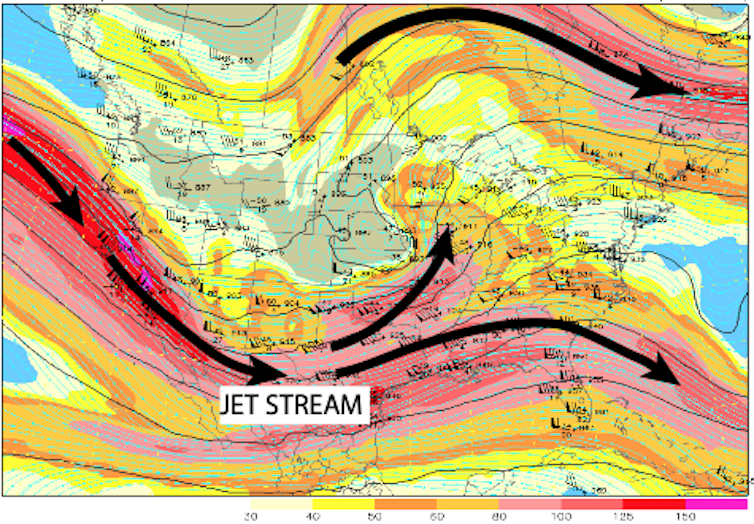
Because Earth rotates, these upper-altitude winds blow from west to east. Waves in the jet stream – a consequence of Earth’s rotation and variations in the surface land, terrain and oceans – can cause air to diverge, or spread out, at certain points. As the air spreads out, the number of air molecules in a column decreases, ultimately reducing the air pressure at Earth’s surface.

The pressure can drop quite dramatically over a few days or even just a few hours, leading to the birth of a low-pressure system – what meteorologists call an extratropical cyclone.

The opposite chain of events, with air converging at other locations, can form high pressure at the surface.

In between these low-pressure and high-pressure systems is a strong change in pressure over a distance – a pressure gradient. And that pressure gradient leads to strong winds. Earth’s rotation causes these winds to spiral around areas of high and low pressure. These highs and lows are like large circular mixers, with air blowing clockwise around high pressure and counterclockwise around low pressure. This flow pattern blows warm air northward toward the poles east of lows and cool air southward toward the equator west of lows.

A maps shows pressure changes don't follow a straight line.
A map illustrates lines of surface pressure, called isobars, with areas of high and low pressure marked for March 14, 2025. Winds are strongest when isobars are packed most closely together. Plymouth State University, CC BY-NC-SA

As the waves in the jet stream migrate from west to east, so do the surface lows and highs, and with them, the corridors of strong winds.

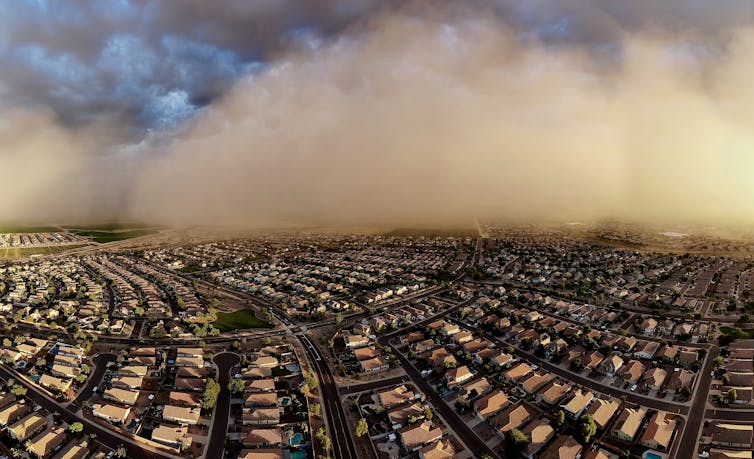
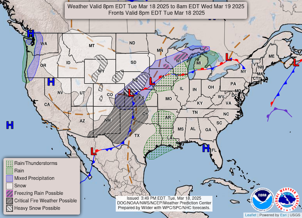
That’s what the U.S. experienced when a strong extratropical cyclone caused winds stretching thousands of miles that whipped up dust storms and spread wildfires, and even caused tornadoes and blizzards in the central and southern U.S. in March 2025.

Whipping up dust storms and spreading fires

The jet stream over the U.S. is strongest and often the most “wavy” in the springtime, when the south-to-north difference in temperature is often the strongest.

Winds associated with large-scale pressure systems can become quite strong in areas where there is limited friction at the ground, like the flat, less forested terrain of the Great Plains. One of the biggest risks is dust storms in arid regions of west Texas or eastern New Mexico, exacerbated by drought in these areas.

Downtown is barely visible through a haze of dust.
A dust storm hit Albuquerque, N.M., on March 18, 2025. Another dust storm a few dats earlier in Kansas caused a deadly pileup involving dozens of vehices on I-70. AP Photo/Roberto E. Rosales

When the ground and vegetation are dry and the air has low relative humidity, high winds can also spread wildfires out of control.

Even more intense winds can occur when the pressure gradient interacts with terrain. Winds can sometimes rush faster downslope, as happens in the Rockies or with the Santa Ana winds that fueled devastating wildfires in the Los Angeles area in January.

Violent tornadoes and storms

Of course, winds can become even stronger and more violent on local scales associated with thunderstorms.

When thunderstorms form, hail and precipitation in them can cause the air to rapidly fall in a downdraft, causing very high pressure under these storms. That pressure forces the air to spread out horizontally when it reaches the ground. Meteorologists call these straight line winds, and the process that forms them is a downburst. Large thunderstorms or chains of them moving across a region can cause large swaths of strong wind over 60 mph, called a derecho.

Finally, some of nature’s strongest winds occur inside tornadoes. They form when the winds surrounding a thunderstorm change speed and direction with height. This can cause part of the storm to rotate, setting off a chain of events that may lead to a tornado and winds as strong as 300 mph in the most violent tornadoes.

How a tornado forms. Source: NOAA.

Tornado winds are also associated with an intense pressure gradient. The pressure inside the center of a tornado is often very low and varies considerably over a very small distance.

It’s no coincidence that localized violent winds from thunderstorm downbursts and tornadoes often occur amid large-scale windstorms. Extratropical cyclones often draw warm, moist air northward on strong winds from the south, which is a key ingredient for thunderstorms. Storms also become more severe and may produce tornadoes when the jet stream is in close proximity to these low-pressure centers. In the winter and early spring, cold air funneling south on the northwest side of strong extratropical cyclones can even lead to blizzards.

So, the same wave in the jet stream can lead to strong winds, blowing dust and fire danger in one region, while simultaneously triggering a tornado outbreak and a blizzard in other regions.The Conversation

Chris Nowotarski, Associate Professor of Atmospheric Science, Texas A&M University

This article is republished from The Conversation under a Creative Commons license. Read the original article.

Lake County Library Literacy Program provides important training

Details
Written by: LAKE COUNTY NEWS REPORTS
Published: 09 April 2025
LAKE COUNTY, Calif. — As California Library Week is marked this week, the Lake County Library is preparing to train a new group of volunteers in its Literacy Program.

The Lake County Library Literacy Program will host a springtime new tutor training on Wednesday, April 16, at the Redbud Library, located at 14785 Burns Valley Road in Clearlake.

The training is free and will take place from 10 a.m. to 4 p.m.

Light snacks and refreshments will be provided, along with training materials at no cost.

Tutors are in high demand at the Library Literacy Program, with more volunteer tutors needed in the Clearlake area, bilingual tutors for the English as a Second Language Program, and tutors available and willing to tutor at the Lake County Jail.

A recent survey of adult skills indicated 26% of Lake County adults have literacy skills at level one or below.

Many adults want to improve their reading and writing skills so they can access better jobs, further their own education, advocate for their children, and overall improve their way of life.

Through hard work and perseverance, adult learners can change their own, and their family’s lives, for the better. Becoming a tutor can help someone to a better future.

No experience is needed, and ongoing support and workshops are provided for tutors. Upon completion of the training, tutors will be matched with adult learners in a variety of settings around the county.

Those who would like to help adults improve their literacy skills are encouraged to attend.

Hosted by Literacy Program Coordinator Georgina Marie Guardado and facilitated by Lake County Literacy Coalition Board Member Pam Klier, participants will learn useful techniques for teaching adults to read and write.

Learn more about the Literacy Program online at https://www.lakecountyca.gov/836/Literacy-Program. 

For more information or to register for tutor training, please call 707-263-7633 or email This email address is being protected from spambots. You need JavaScript enabled to view it..

Middletown Area Town Hall to discuss Valley Fire anniversary, hold election for alternates

Details
Written by: Elizabeth Larson
Published: 09 April 2025
MIDDLETOWN, Calif. — The Middletown Area Town Hall, or MATH, will meet this week to discuss plans for the Valley Fire anniversary, hear project updates and hold an election.

MATH will meet at 7 p.m. Thursday, April 10, in the Middletown Community Meeting Room/Library at 21256 Washington St., Middletown. The meeting is open to the public.

Zoom will not be available. Viewers can participate via PEG TV at www.youtube.com/LakeCountyPegTV. 

On the agenda is a discussion about plans for the 10th anniversary of the Valley Fire in September.

There also will be updates on Middletown area projects such as the NinaStar cannabis project, proposed campgrounds, the Guenoc Maha project and the Middletown Area Plan Update.

Action items include an election for alternates for the MATH Board, a bylaws revision and correspondence.

MATH also will discuss downtown a Caltrans safety improvement project, a possible time change for the meetings and a firewise community designation.

MATH — established by resolution of the Lake County Board of Supervisors on Dec. 12, 2006 — is a municipal advisory council serving the residents of Anderson Springs, Cobb, Coyote Valley (including Hidden Valley Lake), Long Valley and Middletown.

For more information email This email address is being protected from spambots. You need JavaScript enabled to view it.. 

Email Elizabeth Larson at This email address is being protected from spambots. You need JavaScript enabled to view it.. Follow her on Twitter, @ERLarson, and on Bluesky, @erlarson.bsky.social. Find Lake County News on the following platforms: Facebook, @LakeCoNews; X, @LakeCoNews; Threads, @lakeconews, and on Bluesky, @lakeconews.bsky.social.

With peak fire season on horizon, California launches statewide wildfire preparedness campaign

Details
Written by: LAKE COUNTY NEWS REPORTS
Published: 09 April 2025


“Prepare your home and property! Start at the house and work your way out.” Millions of Californians will soon see that message as the state launches a new wildfire preparedness campaign to support preparation efforts for fire season.

As California heads into peak wildfire season, Cal Fire is urging residents across the state to take proactive steps now to protect their homes and communities.

This week’s campaign launch follows Gov. Gavin Newsom’s action last month proclaiming a state of emergency to fast-track critical projects protecting communities from wildfire, ahead of peak fire season.

This year has already seen an unprecedented start to the year with January’s Eaton and Palisades fires in Los Angeles. These fires rank as the second and third most destructive in California’s history, underpinning the importance of acting now to prepare one’s family, property, and community for wildfire.

“The Los Angeles fires are a stark reminder of the year-round threat wildfire poses for our communities. As we head into peak fire season, we’re ramping up efforts to communicate with those in areas where preparedness measures like home hardening and defensible space can save lives. Now is the time to prepare your home and property,” said Gov. Newsom.

This year’s campaign emphasizes two essential strategies in wildfire preparedness: home hardening and defensible space.

Now through late May residents across the state will see digital and social media advertising, posters and materials at hardware and convenience stores, and messaging at gas pumps and other popular locations in Wildland Urban Interface communities.

Outreach will be delivered in both English and Spanish to reach as many Californians as possible.

Creating a five foot buffer zone of defensible space, known as Zone 0, and taking steps to harden your home has been scientifically proven to be the most effective way to increase the likelihood of your home surviving a wildfire.

Gov. Newsom has invested unprecedented resources into wildfire response and prevention, including nearly doubling Cal Fire’s budget to $4 billion and investing 10x the amount than when the governor took office for forest and land management.

The state has also created the world’s largest aerial firefighting fleet, increased the use of prescribed burns, and implemented new technologies including AI and satellite technology to fight fires.

Key tips to prepare for wildfire

Home hardening:

Install or upgrade to fire-resistant materials on roofs, vents, siding, windows, and decks.

Clear debris from roofs, gutters, vents, and under decks.

Seal all cracks and openings larger than 1/8 inch to prevent embers from entering the home.

Defensible space:

Maintain a 5-foot ember-resistant zone immediately around the home—no flammable vegetation or materials.

Maintain 100 feet of defensible space, including trimming trees, cutting grasses, and removing dead vegetation.

Store combustible items (firewood, propane tanks, vehicles) at least 30 feet away from structures.

To make preparation easier, CAL FIRE offers the firePLANNER tool at ReadyForWildfire.org, where residents can:

Create a custom wildfire readiness plan.

Access checklists, safety tips, and alerts.

Stay informed with real-time wildfire and evacuation updates.

Now is the time to act. Start at the house and work your way out. Learn more at ReadyForWildfire.org.
  1. The trade deficit isn’t an emergency – it’s a sign of America’s strength
  2. Lake County supervisors approve letter supporting school and road funding after federal budget exclusion
  3. Authorities identify remains of missing woman; reward offered for information about case
  • 326
  • 327
  • 328
  • 329
  • 330
  • 331
  • 332
  • 333
  • 334
  • 335
How to resolve AdBlock issue?
Refresh this page