 How to resolve AdBlock issue?
News
About 46 million Americans – 14% of the nation’s inhabitants – are currently classified as living in rural areas. That number could jump to 64 million – an increase of nearly 40% – without anyone moving into a new home. That could actually hurt small cities and rural communities across the country.
The federal government classifies communities’ characteristics based on their populations, according to a definition created by the federal Office of Management and Budget. The criteria haven’t substantially changed since the 1940s. Since then, the U.S. population has more than doubled, from 152 million in 1950 to more than 328 million in 2019.
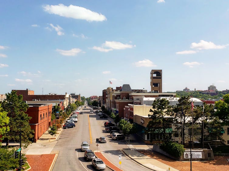
The main dividing line is between communities – which include both towns and cities and their surrounding counties – with more than 50,000 people and those with fewer than that number. Over the past 70 years, the number of areas with at least that many people has increased from 168 to 384 as small towns have grown into small cities. For example, from 1950 to 2010, the population of Lawrence, Kansas, grew from 23,351 to 87,643.
Under the current definition, Colbert County, Alabama – population 54,428 – is in the same category as Los Angeles County – population over 10 million. As the Trump administration ended, federal officials decided some more nuance would be useful in understanding American communities. They proposed to change the dividing line to populations of more than 100,000 – and the effort appears to be continuing under the Biden administration.
That change would effectively move everyone who lives in places with 50,000 to 100,000 from urban to rural life, because their cities, including San Luis Obispo, California, and Battle Creek, Michigan, will no longer be considered large enough to count as metropolitan.
Redefining rural
The government doesn’t specifically use this system to label places as “urban” or “rural.” Instead, there are three government categories – “metropolitan,” “micropolitan” and “outside a core based statistical area.” However, most government agencies, researchers, advocates and media outlets use these classifications to sort communities into two groups – equating “metropolitan” with “urban” and the other two categories together as “rural.”
Making the proposed change would mean 144 areas with populations between 50,000 and 100,000, and the 251 counties they occupy, would no longer be classified as “metropolitan,” but rather as “micropolitan” – and therefore effectively rural – including Flagstaff, Arizona, and Blacksburg, Virginia. The change would leave Wyoming without any metropolitan areas at all.
The Office of Management and Budget is accepting comments about this proposed change until March 19.
Looking at the numbers
Changing how rural areas are defined could change Americans’ understanding of rural life.
For instance, the current data reveal that rural areas have less access to broadband internet and health care services.
But if the homes and communities of 18 million more Americans are added to those rural statistics, the numbers could look better. That rosier picture – which would not be the result of any actual changes to Americans’ lives – could reduce public and political pressure to improve life in rural communities.
It’s also not clear whether 100,000 is the right boundary for urban living – or of there is an exact number at all. To people in major cities, a community of 80,000 like Santa Fe, New Mexico, may be more similar to the 22,000-person Roseburg, Oregon, than to Chicago or Miami. To a rancher on the Plains, with fewer than one person per square mile, though, Santa Fe may qualify as a “big city,” with chain stores, hospitals and government offices.
More than a statistical shift
Though the government’s proposal says it’s meant as a statistical change only, the classifications are commonly used by government agencies, charities and other organizations to determine which communities are eligible for their funding or programs.
The change could make many small American cities, which would be newly identified as rural, ineligible for money to help community planning and public transit – even if they currently get that money.
Communities currently designated as rural may be hurt, too. If Congress and states don’t allocate more funds to serve the increased number of people classified as living in rural areas, the money that is available – like rural health grants – would be spread more thinly.
[Deep knowledge, daily. Sign up for The Conversation’s newsletter.]![]()
Devon Brenner, Assistant VP for Outreach and Initiatives, Office of Research and Economic Development, and Professor, College of Education, Mississippi State University and Jesse Longhurst, Assistant Professor of Education, Southern Oregon University
This article is republished from The Conversation under a Creative Commons license. Read the original article.
DWR encourages community members and water managers to review the publication and provide input.
“Water touches nearly every aspect of our lives. Groundwater provides drinking water to millions of Californians, sustains natural environments and farms, and helps support jobs,” said DWR Director Karla Nemeth. “The information in California’s Groundwater – Update 2020 is vital to local water agencies and communities as they work on locally driven solutions for the long-term reliability of their groundwater.”
This version of California’s Groundwater provides a comprehensive look at statewide groundwater activities, compiling technical information and data from 2003 to 2020.
This bulletin recognizes the historic passage of the Sustainable Groundwater Management Act, or SGMA, in 2014 and builds a statewide framework to share new information and progress made by locals who are managing groundwater basins across the state.
It also highlights emerging topics such as water markets and the impacts of climate change on groundwater and summarizes groundwater information for each of the state’s 10 hydrologic regions.
The publication contains a Highlights overview section in English and Spanish, regional summaries and a detailed statewide report, which features current knowledge of groundwater resources including information on the location, characteristics, use, management status and conditions of the state’s groundwater. The publication also presents findings and recommendations that support the future management and protection of groundwater.
This information can help communities and local water managers work together to find unique ways to manage their groundwater basins for long-term reliability and support actions being implemented as part of Governor Gavin Newsom’s 2020 California Water Resilience Portfolio.
California’s Groundwater is organized to share the growing body of groundwater data that is available now and will continue to be submitted by local agencies in the future as part of the implementation of SGMA. DWR is developing a companion California’s Groundwater web-based dashboard leveraging the California Natural Resources Agency Open Data Platform to improve the access and timeliness of statewide groundwater information, making it easily available for water managers and the public to use.
DWR will present an overview of California’s Groundwater at a public webinar meeting on March 30, 2021, at noon.
A 45-day public comment period is now open on the draft report and companion web content. All comments will be reviewed and will provide valuable feedback to DWR to improve the analysis, reporting and access to California’s groundwater information. Public comments can be emailed to
The final version of California’s Groundwater is expected to be released in summer 2021.
For more information, visit California’s Groundwater webpage.
Dogs available for adoption this week include mixes of basset hound, border collie, boxer and pit bull.
Dogs that are adopted from Lake County Animal Care and Control are either neutered or spayed, microchipped and, if old enough, given a rabies shot and county license before being released to their new owner. License fees do not apply to residents of the cities of Lakeport or Clearlake.
The following dogs at the Lake County Animal Care and Control shelter have been cleared for adoption (additional dogs on the animal control Web site not listed are still “on hold”).
Call Lake County Animal Care and Control at 707-263-0278 or visit the shelter online at http://www.co.lake.ca.us/Government/Directory/Animal_Care_And_Control.htm for information on visiting or adopting.

Boxer-pit bull terrier mix
This female boxer-pit bull mix has a short red coat.
She is in kennel No. 18, ID No. 14356.

Female border collie mix
This young female border collie mix has a medium-length black and white coat.
She is in kennel No. 19, ID No. 14414.
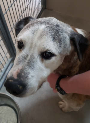
Male pit bull terrier
This senior male pit bull terrier has a short tan and white coat.
He is in kennel No. 22, ID No. 14392.
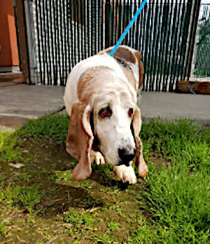
‘Molly’
“Molly” is a senior female basset hound with a short tan and white coat.
She has been spayed.
She is in kennel No. 27, ID No. 14410.
Email Elizabeth Larson at
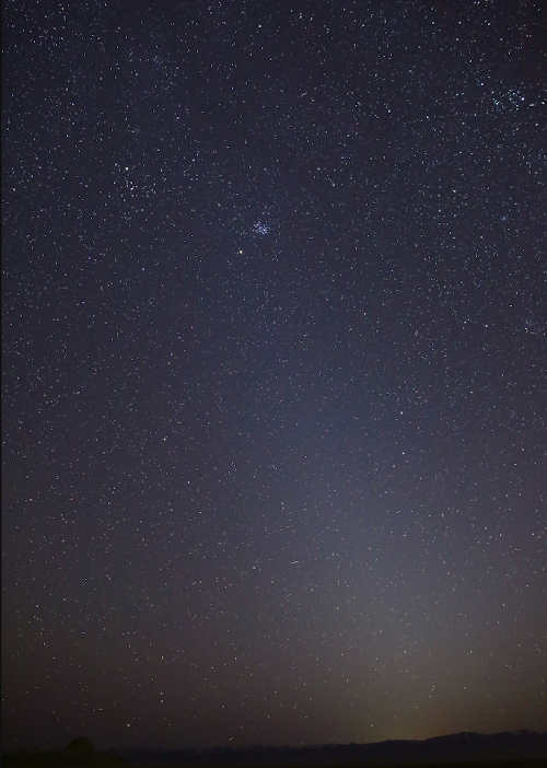
Look up to the night sky just before dawn, or after dusk, and you might see a faint column of light extending up from the horizon.
That luminous glow is the zodiacal light, or sunlight reflected toward Earth by a cloud of tiny dust particles orbiting the Sun.
Astronomers have long thought that the dust is brought into the inner solar system by a few of the asteroid and comet families that venture in from afar.
But now, a team of Juno scientists argues that Mars may be the culprit. They first published their finding online on Nov. 11, 2020, in the Journal of Geophysical Research: Planets, with a final peer-reviewed paper published on March 9, 2021.
An instrument aboard the Juno spacecraft serendipitously detected dust particles slamming into the spacecraft during its journey from Earth to Jupiter.
The impacts provided important clues to the origin and orbital evolution of the dust, resolving some mysterious variations of the zodiacal light.
Though their discovery has big implications, the scientists who spent years studying cosmic debris did not set out to do so. “I never thought we’d be looking for interplanetary dust,” said John Leif Jørgensen, a professor at the Technical University of Denmark.
Jørgensen designed the four star trackers that are part of Juno’s magnetometer investigation. These onboard cameras snap photos of the sky every quarter of a second to determine Juno’s orientation in space by recognizing star patterns in its images — an engineering task essential to the magnetometer’s accuracy.
But Jørgensen hoped his cameras might also catch sight of an undiscovered asteroid. So he programmed one camera to report things that appeared in multiple consecutive images but weren’t in the catalog of known celestial objects.
He didn’t expect to see much: Nearly all objects in the sky are accounted for in the star catalog. So when the camera started beaming down thousands of images of unidentifiable objects — streaks appearing then mysteriously disappearing — Jørgensen and his colleagues were baffled. “We were looking at the images and saying, ‘What could this be?’” he said.

Jørgensen and his team considered many plausible and some implausible causes. There was the unnerving possibility that the star camera had caught a leaking fuel tank on Juno. “We thought, ‘Something is really wrong,’” Jørgensen said. “The images looked like someone was shaking a dusty tablecloth out their window.”
It wasn’t until the researchers calculated the apparent size and velocity of the objects in the images that they finally realized something: Dust grains had smashed into Juno at about 10,000 miles (or 16,000 kilometers) per hour, chipping off submillimeter pieces.
“Even though we’re talking about objects with only a tiny bit of mass, they pack a mean punch,” said Jack Connerney, Juno’s magnetometer investigation lead, and the mission’s deputy principal investigator, who’s based at NASA’s Goddard Space Flight Center in Greenbelt, Maryland.
As it turned out, the spray of debris was coming from Juno’s expansive solar panels — the biggest and most sensitive unintended dust detector ever built.
“Each piece of debris we tracked records the impact of an interplanetary dust particle, allowing us to compile a distribution of dust along Juno’s path,” Connerney said. Juno launched in 2011. After a deep-space maneuver in the asteroid belt in 2012, it returned to the inner solar system for an Earth gravity assist in 2013, which catapulted the spacecraft towards Jupiter.
This visualization shows NASA’s Juno’s spacecraft on its five-year flight path to Jupiter, beginning with its launch from NASA’s Kennedy Space Center in Florida in 2011.
Connerney and Jørgensen noticed that the majority of dust impacts were recorded between Earth and the asteroid belt, with gaps in the distribution related to the influence of Jupiter’s gravity. According to the scientists, this was a radical revelation.
Before now, scientists have been unable to measure the distribution of these dust particles in space. Dedicated dust detectors have had limited collection areas and thus limited sensitivity to a sparse population of dust. They mostly count the more abundant and much smaller dust particles from interstellar space. In comparison, Juno’s expansive solar panels have 1,000 times more collection area than most dust detectors.
Juno scientists determined that the dust cloud ends at Earth because Earth’s gravity sucks up all the dust that gets near it. “That’s the dust we see as zodiacal light,” Jørgensen said.
As for the outer edge, around 2 astronomical units (AU) from the Sun (1 AU is the distance between Earth and the Sun), it ends just beyond Mars. At that point, the scientists report, the influence of Jupiter’s gravity acts as a barrier, preventing dust particles from crossing from the inner solar system into deep space. This same phenomenon, known as orbital resonance, also works the other way, where it blocks dust originating in deep space from passing into the inner solar system.
The profound influence of the gravity barrier indicates that the dust particles are in a nearly circular orbit around the Sun, Jørgensen said. “And the only object we know of in almost circular orbit around 2 AU is Mars, so the natural thought is that Mars is a source of this dust,” he said.
“The distribution of dust that we measure better be consistent with the variation of zodiacal light that has been observed,” Connerney said.
The researchers developed a computer model to predict the light reflected by the dust cloud, dispersed by gravitational interaction with Jupiter that scatters the dust into a thicker disk.
The scattering depends only on two quantities: the dust inclination to the ecliptic and its orbital eccentricity. When the researchers plugged in the orbital elements of Mars, the distribution accurately predicted the tell-tale signature of the variation of zodiacal light near the ecliptic.
“That is, in my view, a confirmation that we know exactly how these particles are orbiting in our solar system,” Connerney said, “and where they originate.”
While there is good evidence now that Mars, the dustiest planet we know of, is the source of the zodiacal light, Jørgensen and his colleagues cannot yet explain how the dust could have escaped the grip of Martian gravity. They hope other scientists will help them.
In the meantime, the researchers note that finding the true distribution and density of dust particles in the solar system will help engineers design spacecraft materials that can better withstand dust impacts. Knowing the precise distribution of dust may also guide the design of flight paths for future spacecraft in order to avoid the highest concentration of particles. Tiny particles traveling at such high velocities can gouge up to 1,000 times their mass from a spacecraft.
Juno’s solar arrays escaped harm because the solar cells are well protected against impact on the back — or dark — side of the array by the support structure.
Lonnie Shekhtman works for NASA’s Goddard Space Flight Center in Greenbelt, Maryland.

LAKEPORT, Calif. – The National League of Cities has announced the election of Lakeport City Councilmember Mireya Turner to three committees within the organization that is a resource and advocate for 19,000 cities, towns and villages, representing more than 218 million Americans.
Turner is serving her second term on the Lakeport City Council. During her time on the council, she also has served as mayor.
“I am honored to serve on these committees, and am excited to take the rural, small city voice of Lakeport to the national table on these important issues,” Turner told Lake County News.
In addition to her efforts on behalf of the city of Lakeport, Turner is the planning manager for the city of Ukiah.
National League of Cities, or NLC, committees and councils bring together leaders from communities that are similar in size, type or another important characteristic.
Turner will represent the city of Lakeport and the Redwood Empire Division of the League.
“These appointments are a big deal for Lakeport to be represented at the national level by Councilmember Turner. We appreciate and applaud her engagement with the NLC’s advocacy efforts,” said City Manager Kevin Ingram.
The Community and Economic Development Committee is responsible for developing policy positions and leading NLC’s advocacy on issues involving housing, community and economic development, land use, recreation and parks, historic preservation and international competitiveness.
In addition, the committee leads efforts in support of federal grant programs that support these activities, including the Community Development Block Grant program.
Turner was elected to a one-year term, announced by NLC President Kathy Maness, councilmember for Lexington, South Carolina.
“Our member councils are the voices of what’s happening on the ground in our communities,” said Maness. “I am proud to have Mireya Turner join these committees on behalf of her residents and the region.”
The Race, Equity and Leadership, or REAL, Council provides a space for local elected officials to connect on building equitable communities.
The leadership of the REAL Council offers tangible insights and opportunities to apply a racial equity lens within cities and within each NLC leadership structure.
As a member of the Small Cities Council, or SCC, Turner will participate in sharing ideas and creative solutions to challenges affecting small cities.
Small cities – those with populations of 50,000 or less – make up 80 percent of NLC membership.
The SCC advocates on behalf of America’s cities and towns before Congress, with the administration and at home.
Nature Bowl has been an exciting science event for teams of third- through sixth-grade students for more than 35 years.
Students usually compete in person at natural resource sites throughout CDFW’s North Central Region.
Last year saw the event canceled as a result of the COVID-19 pandemic.
This year, Nature Bowl has been reformatted for the times as a nature challenge to all California families with school-age students.
Just like the spring before us, it’s time for rejuvenation, time to emerge from winter hibernation, time to get outside and give your family a healthy dose of nature.
Your challenge is to work together as a family to compete in five nature-themed activities – and possibly win cool nature-related prizes.
Activity challenges:
– Nature relay: Take a scavenger hunt safari to see the natural world nearby.
– Nature investigations: Discover native plants, animals in your backyard or neighborhood.
– Bell ringers: Invent a fast-paced family game using Nature Bowl 2021 vocabulary.
– Team problem solving: Decipher the events in 12 nature photographs.
– Enviromercials: Create a 60-second ad on a current nature topic specific to California.
The Nature Bowl Family Challenge is open from March 15 through May 14.
Contact