How to resolve AdBlock issue?
Refresh this page
How to resolve AdBlock issue?
Refresh this page
Lake County News,California
  • Home
    • Registration Form
  • News
    • Education
    • Veterans
    • Community
      • Obituaries
      • Letters
      • Commentary
    • Police Logs
    • Business
    • Recreation
    • Health
    • Religion
    • Legals
    • Arts & Life
    • Regional
  • Calendar
  • Contact us
    • FAQs
    • Phones, E-Mail
    • Subscribe
  • Advertise Here
  • Login

News

Forecasters: ‘Pineapple express’ atmospheric river expected to bring large amount of rain; snow also in coming week’s forecast

LAKE COUNTY, Calif. — Forecasters are warning that the amount of rain expected over the next several days due to an intensive atmospheric river could bring flooding, landslides and travel disruptions across Northern California.

“This atmospheric river will unleash the most rainfall Northern California has seen so far this year. Rounds of intense rain could trigger landslides and rockslides,” AccuWeather Chief On-Air Meteorologist Bernie Rayno said. “This is tropical moisture with warmer air, so snow levels will be much higher than we typically see. The heavy rain could melt some of the snowpack in the lower elevations, which could contribute to flooding problems.”

Accuweather said the moisture is flowing into the West via a “pineapple express” atmospheric river, which funnels rich tropical moisture from near Hawaii directly into the West Coast.

“An atmospheric river is essentially a river of moisture that can stretch thousands of miles,” Rayno explained. “Atmospheric rivers can transport tremendous amounts of moisture. There could be up to two feet of rainfall in the coastal ranges and western slopes of the northern Sierra.”

AccuWeather expert meteorologists are forecasting between 2 and 4 inches of rain for San Francisco, 4 to 8 inches for the North Bay, and a zone of 6 to 12 inches of rain in parts of Northern California through Tuesday, with an AccuWeather Local StormMax of 24 inches in the mountains.

The National Weather Service’s updated forecast shows that showers are expected for the coming week, with the potential for snow showers in Lake County’s lower elevations late Tuesday, Wednesday and Thursday.

The forecast said snow levels could drop to between 1,000 and 2,000 feet in elevation, which the National Weather Service said could be the lowest elevation snowfall of the season.

As a result, there could be impacts along Highway 20, forecasters said.

Email Elizabeth Larson at This email address is being protected from spambots. You need JavaScript enabled to view it.. Follow her on Twitter, @ERLarson, and on Bluesky, @erlarson.bsky.social. Find Lake County News on the following platforms: Facebook, @LakeCoNews; X, @LakeCoNews; Threads, @lakeconews, and on Bluesky, @lakeconews.bsky.social.

Snowpack update: Extremely dry conditions in January put dent in early season start, with big regional differences remaining

From left to right, California Department of Water Resources Engineers Anthony Burdock and Chan Modini along with Andy Reising, Snow Surveys and Water Supply Forecasting Unit Manager, conduct the second media snow survey of the 2025 season at Phillips Station in the Sierra Nevada. The snow survey is held approximately 90 miles east of Sacramento off Highway 50 in El Dorado County. Photo taken January 31, 2025. Xavier Mascareñas / California Department of Water Resources.

California’s snowpack has dwindled due to a dry January, according to the latest manual measurement conducted by the state.

The Department of Water Resources, or DWR, on Friday conducted the second snow survey of the season at Phillips Station.

The manual survey recorded 22.5 inches of snow depth and a snow water equivalent of 8 inches, which is 46 percent of average for this location.

The snow water equivalent measures the amount of water contained in the snowpack and is a key component of DWR’s water supply forecast. Statewide, the snowpack is 65 percent of average for this date.

On January 1, the statewide snowpack was 108 percent of average after a series of large storms in November and December boosted snow totals in the Northern Sierra, but significant regional differences kept the Central Sierra just below average and the Southern Sierra well below average.

An excessively dry January has pushed the Northern Sierra back to near average, the Central Sierra to 58 percent of average, and has led the Southern Sierra Nevada to fall to under 50 percent of average.

“Despite a good start to the snowpack in the Northern Sierra in November and December, we can look back as recently as 2013 and 2021 to show how quickly conditions can change for the drier,” said DWR Director Karla Nemeth. “California missed out on critical snow-building storms in January which has pushed the state down below average for this time of year. While we are excited to see some storm activity in the coming days, sustained periods of no precipitation can dry the state out very quickly. For each day it’s not snowing or raining, we are not keeping up with what we need.”

DWR’s electronic readings from 130 stations placed throughout the Sierra Nevada indicate that the statewide snowpack’s snow water equivalent is 10.5 inches, or 65 percent of average for this date.

While forecasts show storm activity may pick up in February, California has seen several years in recent history with large early season snow totals, only for predominantly dry conditions to dominate the rest of the season.

California has effectively managed its reservoirs to keep storage above average for this time of year. Lake Oroville, the State Water Project’s largest reservoir, is currently at 126 percent of average for this time of year. San Luis Reservoir, which is jointly operated by the U.S. Bureau of Reclamation, is at 101 percent of average for this time of year. Reservoirs in Southern California are also near or above their historical averages.

Measuring California’s snowpack is a key component that guides how California’s water supplies are managed. The data and measurements collected help inform water supply and snowmelt runoff forecasts, known as Bulletin 120, that help water managers plan for how much water will eventually reach state reservoirs in the spring and summer. This information is also a key piece in calculating State Water Project allocation forecasts each month.

Despite some recent rain, Southern California is still well below average for yearly precipitation.

To prepare for any weather the region may see the rest of the season, DWR has deployed over 30 Watershed Protection Specialists to assist with the Watershed and Debris Flow Task Force organized by the California Office of Emergency Services, or CalOES.

Members of this task force, including DWR, CalOES, CAL FIRE and over 400 members of the California Conservation Corps, have been working around the clock to protect watersheds around burn scars, place materials to mitigate the risk of debris flows and ensure regional infrastructure including debris flow basins are prepared for incoming storm activity.

On average, California’s snowpack supplies about 30 percent of California’s water needs. Its natural ability to store water is why California’s snowpack is often referred to as California's “frozen reservoir.” Data from these snow surveys and forecasts produced by DWR’s Snow Surveys and Water Supply Forecasting Unit are important factors in determining how DWR manages the state’s water resources.

DWR conducts four or five media-oriented snow surveys at Phillips Station each winter near the first of each month, January through April and, if necessary, May. The next survey is tentatively scheduled for February 28.

For California’s current hydrological conditions, visit https://cww.water.ca.gov.

California Department of Water Resources Engineer Chan Modini and Andy Reising, Snow Surveys and Water Supply Forecasting Unit Manager, conduct the second media snow survey of the 2025 season at Phillips Station in the Sierra Nevada. The snow survey is held approximately 90 miles east of Sacramento off Highway 50 in El Dorado County. Photo taken January 31, 2025. Xavier Mascareñas / California Department of Water Resources

Thompson, Merkley introduce bill to combat health impacts of wildfire smoke

On Friday, U.S. Rep. Mike Thompson (CA-04) and Senator Jeff Merkley (D-OR) introduced the Smoke and Heat Ready Communities Act — legislation to protect communities across the country from the hazardous health, economic, and environmental impacts of severe wildfire smoke and extreme heat events.

Thompson introduced the bill in the House and Merkley introduced the companion bill in the Senate.

“Californians know firsthand the impact breathing wildfire smoke can have on our health,” said Rep. Thompson. “As wildfire smoke and extreme heat become more and more common, the Smoke and Heat Ready Communities Act will help experts better research the impact of wildfire smoke on our communities and provide communities the resources they need to keep Americans safe.”

“When the 2020 Labor Day fires broke out, I drove over 600 miles across Oregon and never once escaped the thick layer of dark smoke that blanketed the state, which threatened public health and dampened everyday life for those under its hazardous plumes,” said Sen. Merkley. “We must ensure Americans are prepared in the face of dangerous smoke and heat that ravage our communities during these deadly disasters. As climate chaos continues to worsen the impacts of natural disasters like wildfires, I’ll keep pushing for research and resources — like the millions in federal funding I secured for smoke readiness last year — to combat this crisis.”

Wildfire smoke contains hazardous pollutants that pose serious health risks, especially for children, the elderly, and individuals with pre-existing heart or lung conditions.

Exposure can cause immediate symptoms — like wheezing, burning eyes, and difficulty breathing — while also aggravating chronic respiratory and cardiovascular diseases.

The effects of this toxic smoke can linger long after the fires are extinguished, with some studies illustrating that major wildfires are followed by more severe flu seasons.

The Smoke and Heat Ready Communities Act provides federal grant funding to states and their efforts to improve air quality. This funding would invest in measures that protect against the harmful effects of wildfire smoke and extreme heat.

The bill also encourages research, development and implementation of strategies to mitigate the impacts of these environmental hazards and support healthy communities.

“People with asthma and COPD are at risk for breathing emergencies after exposure to wildfire smoke or dangerous heat,” said Lynda Mitchell, CEO of Allergy & Asthma Network. “If you inhale particles of wildfire smoke or breathe in hot and humid air filled with allergens or irritants, it can cause your airways to become inflamed and lead to coughing, wheezing and shortness of breath. More than 25 million people have asthma and 24 million live with COPD in the United States – these are life-threatening chronic diseases that are worsened by poor air quality. Allergy & Asthma Network supports the Smoke and Heat Ready Communities Act to improve our country’s air quality and readiness for wildfire smoke and extreme heat.”

“Extreme heat and wildfire smoke are among the most impactful environmental air quality factors in many communities. Poor air quality makes it more difficult for allergists to manage our patients who suffer from asthma. This legislation will make it easier for the EPA to support state and local government in their management of these issues which will make it easier for us to care for our patients. ACAAI endorses this legislation and applauds Congressman Thompson and Senator Merkley for their leadership on this important issue,” said Todd Mahr, MD, executive medical director, American College of Allergy, Asthma and Immunology.

“Smoke and extreme heat are dangerous threats to health that are unfortunately becoming much more common for communities across the country. Providing states and communities funding to prepare for and communicate timely information about the impacts of wildfire smoke and heat will help protect peoples’ health. These extreme weather events are a reality that necessitate the health-focused response this legislation provides,” said Harold Wimmer, president and CEO, American Lung Association.

“There is an urgent and desperate need for funding for research on how wildfire smoke impacts our health and particularly the health of our children, who are uniquely vulnerable to air and chemical pollution. When wildfires consume entire houses, cars, and businesses, everything in them burns and goes into the air. Much of our lives is made up of plastics now, from the clothes we wear to the materials we use in construction. Think PVC pipes and vinyl siding. They contain toxic chemicals, and when they burn, people breathe them in during and after fires — and that air drifts. We cannot fix problems without proper data. We need to know what’s in wildfire smoke — besides, potentially, everything,” said Dominique Browning, director and co-founder, Moms Clean Air Force.

The bill is currently endorsed by the Allergy and Asthma Network; the American College of Allergy, Asthma and Immunology; the American Lung Association; and Moms Clean Air Force.

Thompson represents California’s Fourth Congressional District, which includes all or part of Lake, Napa, Solano, Sonoma and Yolo counties.

Space News: Bennu asteroid reveals its contents to scientists − and clues to how the building blocks of life on Earth may have been seeded


This photo of asteroid Bennu is composed of 12 Polycam images collected on Dec. 2, 2024, by the OSIRIS-REx spacecraft. NASA
Timothy J McCoy, Smithsonian Institution and Sara Russell, Natural History Museum

A bright fireball streaked across the sky above mountains, glaciers and spruce forest near the town of Revelstoke in British Columbia, Canada, on the evening of March 31, 1965. Fragments of this meteorite, discovered by beaver trappers, fell over a lake. A layer of ice saved them from the depths and allowed scientists a peek into the birth of the solar system.

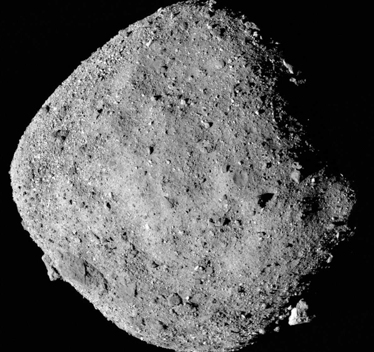
Nearly 60 years later, NASA’s OSIRIS-REx mission returned from space with a sample of an asteroid named Bennu, similar to the one that rained rocks over Revelstoke. Our research team has published a chemical analysis of those samples, providing insight into how some of the ingredients for life may have first arrived on Earth.

Born in the years bracketing the Revelstoke meteorite’s fall, the two of us have spent our careers in the meteorite collections of the Smithsonian Institution in Washington, D.C., and the Natural History Museum in London. We’ve dreamed of studying samples from a Revelstoke-like asteroid collected by a spacecraft.

Then, nearly two decades ago, we began turning those dreams into reality. We joined NASA’s OSIRIS-REx mission team, which aimed to send a spacecraft to collect and return an asteroid sample to Earth. After those samples arrived on Sept. 24, 2023, we got to dive into a tale of rock, ice and water that hints at how life could have formed on Earth.

An illustration of a small spacecraft with solar panels and an extending arm hovers above an asteroid's rocky surface in space.
In this illustration, NASA’s OSIRIS-REx spacecraft collects a sample from the asteroid Bennu. NASA/Goddard/University of Arizona

The CI chondrites and asteroid Bennu

To learn about an asteroid – a rocky or metallic object in orbit around the Sun – we started with a study of meteorites.

Asteroids like Bennu are rocky or metallic objects in orbit around the Sun. Meteorites are the pieces of asteroids and other natural extraterrestrial objects that survive the fiery plunge to the Earth’s surface.

We really wanted to study an asteroid similar to a set of meteorites called chondrites, whose components formed in a cloud of gas and dust at the dawn of the solar system billions of years ago.

The Revelstoke meteorite is in a group called CI chondrites. Laboratory-measured compositions of CI chondrites are essentially identical, minus hydrogen and helium, to the composition of elements carried by convection from the interior of the Sun and measured in the outermost layer of the Sun. Since their components formed billions of years ago, they’re like chemically unchanged time capsules for the early solar system.

So, geologists use the chemical compositions of CI chondrites as the ultimate reference standard for geochemistry. They can compare the compositions of everything from other chondrites to Earth rocks. Any differences from the CI chondrite composition would have happened through the same processes that formed asteroids and planets.

CI chondrites are rich in clay and formed when ice melted in an ancient asteroid, altering the rock. They are also rich in prebiotic organic molecules. Some of these types of molecules are the building blocks for life.

This combination of rock, water and organics is one reason OSIRIS-REx chose to sample the organic-rich asteroid Bennu, where water and organic compounds essential to the origin of life could be found.

Evaporites − the legacy of an ancient brine

Ever since the Bennu samples returned to Earth on Sept. 24, 2023, we and our colleagues on four continents have spent hundreds of hours studying them.

The instruments on the OSIRIS-REx spacecraft made observations of reflected light that revealed the most abundant minerals and organics when it was near asteroid Bennu. Our analyses in the laboratory found that the compositions of these samples lined up with those observations.

The samples are mostly water-rich clay, with sulfide, carbonate and iron oxide minerals. These are the same minerals found in CI chondrites like Revelstoke. The discovery of rare minerals within the Bennu samples, however, surprised both of us. Despite our decades of experience studying meteorites, we have never seen many of these minerals.

We found minerals dominated by sodium, including carbonates, sulfates, chlorides and fluorides, as well as potassium chloride and magnesium phosphate. These minerals don’t form just when water and rock react. They form when water evaporates.

We’ve never seen most of these sodium-rich minerals in meteorites, but they’re sometimes found in dried-up lake beds on Earth, like Searles Lake in California.

Bennu’s rocks formed 4.5 billion years ago on a larger parent asteroid. That asteroid was wet and muddy. Under the surface, pockets of water perhaps only a few feet across were evaporating, leaving the evaporite minerals we found in the sample. That same evaporation process also formed the ancient lake beds we’ve seen these minerals in on Earth.

Bennu’s parent asteroid likely broke apart 1 to 2 billion years ago, and some of the fragments came together to form the rubble pile we know as Bennu.

These minerals are also found on icy bodies in the outer solar system. Bright deposits on the dwarf planet Ceres, the largest body in the asteroid belt, contain sodium carbonate. The Cassini mission measured the same mineral in plumes on Saturn’s moon Enceladus.

We also learned that these minerals, formed when water evaporates, disappear when exposed to water once again – even with the tiny amount of water found in air. After studying some of the Bennu samples and their minerals, researchers stored the samples in air. That’s what we do with meteorites.

Unfortunately, we lost these minerals as moisture in the air on Earth caused them to dissolve. But that explains why we can’t find these minerals in meteorites that have been on Earth for decades to centuries.

Fortunately, most of the samples have been stored and transported in nitrogen, protected from traces of water in the air.

Until scientists were able to conduct a controlled sample return with a spacecraft and carefully curate and store the samples in nitrogen, we had never seen this set of minerals in a meteorite.

An unexpected discovery

Before returning the samples, the OSIRIS-REx spacecraft spent over two years making observations around Bennu. From that two years of work, researchers learned that the surface of the asteroid is covered in rocky boulders.

We could see that the asteroid is rich in carbon and water-bearing clays, and we saw veins of white carbonate a few feet long deposited by ancient liquid water. But what we couldn’t see from these observations were the rarer minerals.

We used an array of techniques to go through the returned sample one tiny grain at a time. These included CT scanning, electron microscopy and X-ray diffraction, each of which allowed us to look at the rock at a scale not possible on the asteroid.

Cooking up the ingredients for life

From the salts we identified, we could infer the composition of the briny water from which they formed and see how it changed over time, becoming more sodium-rich.

This briny water would have been an ideal place for new chemical reactions to take place and for organic molecules to form.

While our team characterized salts, our organic chemist colleagues were busy identifying the carbon-based molecules present in Bennu. They found unexpectedly high levels of ammonia, an essential building block of the amino acids that form proteins in living matter. They also found all five of the nucleobases that make up part of DNA and RNA.

Based on these results, we’d venture to guess that these briny pods of fluid would have been the perfect environments for increasingly complicated organic molecules to form, such as the kinds that make up life on Earth.

When asteroids like Bennu hit the young Earth, they could have provided a complete package of complex molecules and the ingredients essential to life, such as water, phosphate and ammonia. Together, these components could have seeded Earth’s initially barren landscape to produce a habitable world.

Without this early bombardment, perhaps when the pieces of the Revelstoke meteorite landed several billion years later, these fragments from outer space would not have arrived into a landscape punctuated with glaciers and trees.The Conversation

Timothy J McCoy, Supervisory Research Geologist, Smithsonian Institution and Sara Russell, Professor of Planetary Sciences, Natural History Museum

This article is republished from The Conversation under a Creative Commons license. Read the original article.

CPUC awards $15 million to three Lake County broadband infrastructure projects

LAKE COUNTY, Calif. — On Thursday, the California Public Utilities Commission approved $48 million for eight broadband infrastructure projects — including three in Lake County — as part of the multi-year $2 billion Last Mile Federal Funding Account grant program, which expands broadband internet access for underserved and unserved communities across California.

The CPUC said the Last Mile Federal Funding Account “highlights the state’s commitment to bridging the digital divide through Broadband For All.”

The proposed projects will serve predominantly disadvantaged and low-income communities across the state.

The Last Mile Federal Funding Account broadband infrastructure grants the CPUC awarded on Thursday include $15 million for three projects in Lake County, benefitting 7,000 residents; $17 million for three projects in Fresno County, benefiting approximately 13,000 individuals; and $17 million for two projects in Sonoma County, benefiting approximately 2,100 Californians.

In Lake County, two of the projects are proposed by AT&T around Hidden Valley Lake and Mount Hannah in the south county, and the third by Mediacom, which will have sites near Clearlake, Clearlake Oaks, Kelseyville and Lakeport, according to the grant documents.

The companies submitted the grant applications in September of 2023.

The commission is awarding $2,218,869, or 68% of the cost, for AT&T’s Lake-1 project, which will serve 620 unserved locations and offer service to a total population of 3,073. It will provide up to 5,000/5,000 Mbps service to consumers and include the deployment of 103 miles of last-mile fiber. The project’s network infrastructure will be 12% underground and 88% aerial.

AT&T’s second project, Lake-1E, will receive up to $4 million of the total project cost of $5,906,345. It will serve 504 unserved locations and benefit an estimated population of 1,671. The project also will provide up to 5,000/5,000 Mbps service to consumers. It will include the deployment of 60 miles of last-mile fiber, with 20 percent of the infrastructure underground and 80 percent aerial.

The third grant award of up to $8,429,712 goes to Mediacom’s Lake County Grant Build project, which proposes to serve an estimated 1,037 unserved locations and benefit up to 2,249 residents. It will provide up to 2,000/1,000 Mbps service to consumers and deploy approximately 50 miles of last-mile fiber and 35 miles of middle mile fiber. The network infrastructure will be 14 percent underground and 86 percent aerial.

“We are putting these funds to work, generating quality jobs, bolstering our economy, and building fast, reliable, and affordable broadband infrastructure,” said CPUC President Alice Reynolds.

“Due to historical underinvestment, many communities across California lack access to fast, reliable, and reasonably priced broadband service, which is now a necessity to fully participate in work, school, and daily life,” said Commissioner Darcie L. Houck. “These Federal Funding Account grants represent another step in alleviating this historical disparity by closing the digital divide and providing Broadband for All Californians. I look forward to seeing the benefits of these investments that will provide opportunities for many generations to come in Sonoma, Fresno, and Lake counties.”

Currently, the total amount in Federal Funding Account grants awarded is over $1 billion for projects in 51 counties, with $550 million set to be appropriated to the Last Mile program in the 2027-28 state budget.

The CPUC did not say if the funding is in any jeopardy due to actions by the Trump Administration.

Established under Senate Bill 156 (2021), the CPUC said its Last Mile Federal Funding Account is fueling economic growth across rural, tribal, and urban communities statewide.

Thursday’s approval is part of a process to award last mile broadband grants to projects in every region in the state to established internet service providers, small providers, local governments, tribes and special districts.

Email Elizabeth Larson at This email address is being protected from spambots. You need JavaScript enabled to view it.. Follow her on Twitter, @ERLarson, and on Bluesky, @erlarson.bsky.social. Find Lake County News on the following platforms: Facebook, @LakeCoNews; X, @LakeCoNews; Threads, @lakeconews, and on Bluesky, @lakeconews.bsky.social.

California readies for incoming winter storm; governor pre-deploys resources to protect communities

With an atmospheric river expected to arrive in Northern California this weekend, California is pre-deploying resources — including thousands of personnel — to help protect communities from storm impacts.

Gov. Gavin Newsom has directed the Governor’s Office of Emergency Services, or Cal OES, to coordinate state and local partners to deploy emergency resources to support impacted communities. State officials are urging people to take precautions now before the storm arrives.

National Weather Service Sacramento is forecasting a moderate to strong atmospheric river to begin Friday and continue into next week. Prolonged periods of rain and mountain snow are expected, with the potential for flash flooding and rising creeks, rivers, and streams.

“We know from experience that these storms can pack a punch,” said Gov. Gavin Newsom. “California is pre-deploying resources and thousands of boots on the ground throughout Northern California so we can be ready at a moment’s notice to protect people. The best thing people can do now is to prepare and stay alert.”

Cal OES is monitoring weather impacts and working closely with local areas that are forecasted to be affected. In particular, the state is closely monitoring recent burn scar areas that pose the threat of mudslides and debris flows. Together, the state is preparing:

• The State-Federal Flood Operations Center is monitoring forecasts and coordinating with partners.

• In collaboration with the California-Nevada River Forecast Center (CNRFC), DWR engineers and CNRFC hydrologists are conducting river forecasts up to four times a day.

• DWR has pre-positioned flood fight materials in Northern and Central California including over 3.7 million burlap sandbags and 162 flood fight material containers across 25 counties.

• The flood control system is working as intended with flood space available throughout the system. Water can move throughout California’s flood control system including natural weirs overtopping, water in the region’s bypasses, and potential use of spillways at reservoirs.

• Caltrans has 2,500 personnel and 1,253 pieces of storm equipment including snowplows, backhoes, and storm drain clearing equipment.

• 133 CAL FIRE engines and 7 CAL FIRE hand crews staffed across the northern region that are ready to respond.

An atmospheric river could bring an increased risk of power outages, flooding in small streams and low-lying areas, and debris, rocks and mudslides on roadways.

Cal OES is encouraging residents to reduce injury risks from falling limbs and trees by staying inside, not driving through flooded roadways and preparing in advance for power outages.

Residents in the affected counties are urged to stay informed and listen to local authorities about actions they should take including evacuation orders or safety recommendations. In burn scar areas, officials recommend preparing for possible sudden debris flows by having a go-bag packed and knowing evacuation routes.

Go to ready.ca.gov for tips to prepare for the incoming storm.
  • 264
  • 265
  • 266
  • 267
  • 268
  • 269
  • 270
  • 271
  • 272
  • 273

Community

  • Lake County Wine Alliance offers sponsor update; beneficiary applications open 

  • Mendocino National Forest announces seasonal hiring for upcoming field season

Public Safety

  • Lakeport Police logs: Thursday, Jan. 15

  • Lakeport Police logs: Wednesday, Jan. 14

Education

  • Woodland Community College receives maximum eight-year reaffirmation of accreditation from ACCJC

  • SNHU announces Fall 2025 President's List

Health

  • California ranks 24th in America’s Health Rankings Annual Report from United Health Foundation

  • Healthy blood donors especially vital during active flu season

Business

  • Two Lake County Mediacom employees earn company’s top service awards

  • Redwood Credit Union launches holiday gift and porch-to-pantry food drives

Obituaries

  • Rufino ‘Ray’ Pato

  • Patty Lee Smith

Opinion & Letters

  • The benefits of music for students

  • How to ease the burden of high electric bills

Veterans

  • CalVet and CSU Long Beach team up to improve data collection related to veteran suicides

  • A ‘Big Step Forward’ for Gulf War Veterans

Recreation

  • Wet weather trail closure in effect on Upper Lake Ranger District

  • Mendocino National Forest seeking public input on OHV grant applications

  • State Parks announces 2026 Anderson Marsh nature walk schedule 

  • BLM lifts seasonal fire restrictions in central California

Religion

  • Kelseyville Presbyterian to host Ash Wednesday service and Lenten dinner Feb. 18

  • Kelseyville Presbyterian Church to hold ‘Longest Night’ service Dec. 21

Arts & Life

  • Auditions announced for original musical ‘Even In Shadow’ set for March 21 and 28

  • ‘The Rip’ action heist; ‘Steal’ grounded in a crime thriller

Government & Politics

  • Lake County Democrats issue endorsements in local races for the June California Primary

  • County negotiates money-saving power purchase agreement

Legals

  • March 3 hearing on ordinance amending code for commercial cannabis uses

  • Feb. 12 public hearing on resolution to establish standards for agricultural roads

How to resolve AdBlock issue?
Refresh this page