 How to resolve AdBlock issue?
News
At the end of America’s Civil War, hundreds of thousands of veterans, both blue and gray alike, set out to lose themselves in the continent’s vast western wilderness.
Large tracts of the country – ostensibly territory of the United States – had never felt the tread of one of its citizens.
This was especially the case in the southwest, where endless deserts and arid high mountain ranges barred all but the foolhardy from entering.
The foolhardy and the scientifically curious, that is. Of course, in the late 1860s, the two were not mutually exclusive.
The American government had been funding exploratory expeditions into the heartland and farther afield since at least Lewis and Clark.
Even as the country raced headlong into civil war, government-subsidized parties mapped out new stretches of wilderness in the Rockies and Sierra Nevada Mountains.
In 1853, America purchased a stretch of land from Mexico in the southwest, completing what today is our border with that country.
It’s true, the conflict between the states put exploration on a bit of a hiatus, but the moment it ended, things went back to normal. The transcontinental railroad got under way and new routes through the southwest were added to the country’s expanding consciousness.
Gradually, the task that had started half a century before was finally ending – fewer and fewer corners of the map remained “unknown territory.”
One stretch that obstinately kept its secrets closed to western exploration was the stretch of land west and south of the Colorado River.
In the late spring of 1869, one man set out to pierce the veil of this mysterious territory and finally bring southeastern Utah and northern Arizona into the national fold.
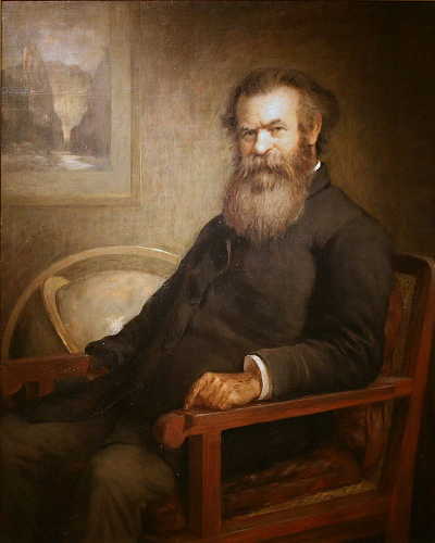
His name was John Wesley Powell.
Described by his sister as the homeliest man she had ever met, others more tactfully compared the 5-foot, 6-inch, one-armed bearded man as a sort of Socrates of the American West.
Today we know him as a founder of the National Geographic Society and a leading American scientist, anthropologist, and geographer of the 19th century. And to think – he never even graduated from college.
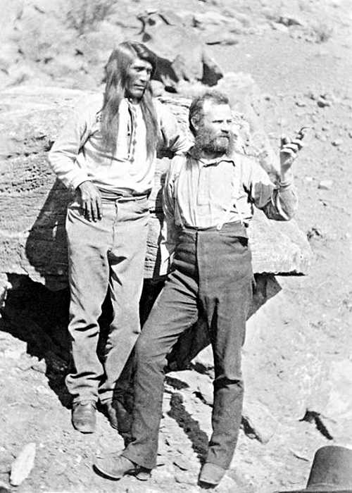
Then again, a college degree mattered little to the band of 11 men who followed the short, tough-looking man of 35 that spring of 1869.
Even with one arm missing – an injury of the recent Civil War – his men knew that Powell had a stubborn tenacity that made him a match in physical endurance to any man among them.
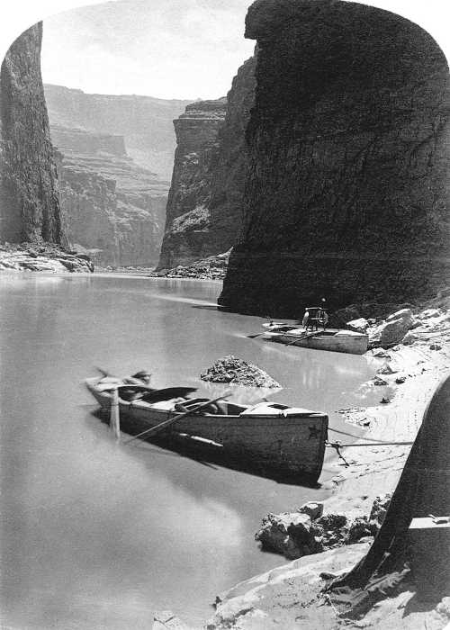
On May 4, 1869, Powell’s team cast their four flat-bottomed boats into the raging waters of the Green River and started a mission of a lifetime.
Following twisting, tortuous rivers, negotiating the rough and dangerous rapids, Powell’s expedition made its way down through the high plateaus of eastern Utah.
They were carried through the heart of towering rocks, which at times completely enfolded them in their embrace, the men working furiously under a noontime shadow cast by their mass.
Whenever they could, the expedition would stop, giving Powell and others of the party time to scramble as best they could up the cliffs to take readings of wind, atmosphere and other measurements they thought necessary to fully record this new territory.
Over the three months and 900 miles they travelled down the rivers, Powell’s expedition almost ran out of rations, and had one of their boats brutally crushed against a cliff wall and consumed beneath the foaming green folds of the river.
As they entered what would become known as the Grand Canyon, a sort of mutiny occurred, forcing the team to come to terms with their dire situation. A tally was taken. Three men determined to clamber out of the canyon and take their chances in the desert, rather than remain on the river for an indeterminate number of additional weeks.
Those three men were never seen again – at least not alive. They fell victim to the agitated bands of American Indians, which by then were fed up with incursions onto their lands.
Those who chose to remain on the river with Powell didn’t have far to go. On Aug. 29, 1869, having beheld the vast majesty of the Grand Canyon in all its splendor, Powell’s expedition exited the canyon and entered open country once more.
He and his men had become the first Americans to explore the length of the Grand Canyon and lower stretches of the Colorado River.
One more corner of the map marked, measured and tallied as part of America’s growing domain.
Antone Pierucci is curator of history at the Riverside County Park and Open Space District and a freelance writer whose work has been featured in such magazines as Archaeology and Wild West as well as regional California newspapers.

CLEARLAKE, Calif. – The Board of Directors of the Anderson Marsh Interpretive Association, or AMIA, has announced a benefit concert called “Music on the Creek” to be held on Saturday, Sept. 8.
The event will take place from noon to 5 p.m. at the Clear Lake Campground, 7805 Cache Creek Way, Clearlake.
Proceeds from the “Music on the Creek” benefit will support AMIA’s work to protect and preserve Anderson Marsh State Historic Park.
Featured musicians, who are all donating their time in order to benefit AMIA, include: Uncle Mike, Dave Hooper, Scott Serena and Angle of Repose, Uncorked with Don Coffin and Andi Skelton, and Humdingers, featuring Bill Bordisso and friends.
Admission to the event is $25 and only 100 tickets will be sold. All tickets must be purchased in advance and no tickets will be sold on the day of the event.
Tickets will be available at Catfish Coffeehouse in Clearlake, Watershed Books in Lakeport and online at www.andersonmarsh.org.
Wine, beer and other refreshments will be available for purchase. The Cactus Grill will be offering tasty food at a very reasonable price.
“This is a chance to listen to music and gather with friends at a beautiful location on the banks of Cache Creek, under the trees at Clear Lake Campground. It should be a lovely afternoon, so come enjoy the day with us and support Anderson Marsh State Historic Park,” said AMIA President Roberta Lyons.
Guests are asked to please bring their own lawn chairs for seating and please leave pets at home. No dogs allowed.
For more information, please email or call
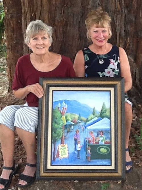
KELSEYVILLE, Calif. – Well-known local artist Carolyn Morris has created the 26th Kelseyville Pear Festival poster using multimedia on canvas.
Morris is a longtime Kelseyville resident who has been painting in the Americana style for many years.
Primarily self-taught, she has taken a few classes along the way, and, is a member of the Konocti Art Society
Her painting depicts volunteers gladly offering home-baked pies and tarts featuring the bounty of the pear harvest.
This charming scene reflects a small country town nestled below Mt. Konocti celebrating a simpler time of traditions.
“Pear Pie, Please” is her fourth poster chosen to represent the Kelseyville Pear Festival.
Main Street, Kelseyville, is where all the action takes place on Saturday, Sept. 29.
Prints of the poster will be for sale at $10 each in the Festival Marketplace booth right in front of the newly created Pear Square.
In the heart of Pear Square find the California Women in Agriculture booth. On sale are genuine luscious fruit pies and tarts. Remember, they always sell out early.
Each year Golden Bartlett and Bartlett level sponsors are awarded framed and matted festival posters.
The original framed art chosen for 2017 and 2018 will be auctioned during the kickoff event.
Morris is donating a third piece, a framed print entitled “Spirit of Kelseyville.” Proceeds will go to the Mendocino Complex fire victims.
The original paintings will be on view at Saw Shop Restaurant, Main Street, Kelseyville, during September.
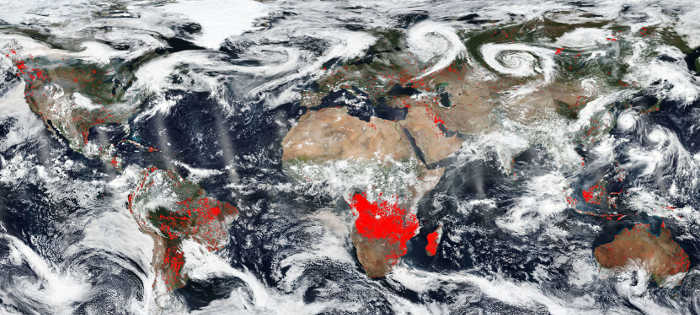
The world is on fire. Or so it appears in this image from NASA's Worldview.
The red points overlaid on the image designate those areas that by using thermal bands detect actively burning fires.
Africa seems to have the most concentrated fires. This could be due to the fact that these are most likely agricultural fires.
The location, widespread nature, and number of fires suggest that these fires were deliberately set to manage land. Farmers often use fire to return nutrients to the soil and to clear the ground of unwanted plants.
While fire helps enhance crops and grasses for pasture, the fires also produce smoke that degrades air quality.
Elsewhere the fires, such as in North America are wildfires for the most part. In South America, specifically Chile has had horrendous numbers of wildfires this year.
A study conducted by Montana State University found that: "Besides low humidity, high winds and extreme temperatures – some of the same factors contributing to fires raging across the United States – central Chile is experiencing a mega drought and large portions of its diverse native forests have been converted to more flammable tree plantations, the researchers said."
More on this study can be found here: https://phys.org/news/2018-08-massive-south-central-chile.html#jCp.
However, in Brazil the fires are both wildfires and man-made fires set to clear crop fields of detritus from the last growing season.
Fires are also commonly used during Brazil’s dry period to deforest land and clear it for raising cattle or other agricultural or extraction purposes.
The problem with these fires is that they grow out of control quickly due to climate issues. Hot, dry conditions coupled with wind drive fires far from their original intended burn area. the Global Fire Watch site (between 8/15 and 8/22) shows 30,964 fire alerts.
Australia is also where you tend to find large bushfires in its more remote areas. Hotter, drier summers in Australia will mean longer fire seasons – and urban sprawl into bushland is putting more people at risk for when those fires break out.
For large areas in the north and west, bushfire season has been brought forward a whole two months to August – well into winter, which officially began 1 June.
According to the Australian Bureau of Meteorology (Bom), the January to July period 2018 was the warmest in NSW since 1910.
As the climate continues to change and areas become hotter and drier, more and more extreme bushfires will break out across the entire Australian continent.
NASA's Earth Observing System Data and Information System (EOSDIS) Worldview application provides the capability to interactively browse over 700 global, full-resolution satellite imagery layers and then download the underlying data. Many of the available imagery layers are updated within three hours of observation, essentially showing the entire Earth as it looks "right now. This satellite image was collected on August 22, 2018. Actively burning fires, detected by thermal bands, are shown as red points. Image Courtesy: NASA Worldview, Earth Observing System Data and Information System (EOSDIS). Caption: Lynn Jenner with information from Global Fire Watch, Australian Bureau of Meteorology, and Phys.org
NORTHERN CALIFORNIA – Thoth was an ancient Egyptian deity with the head of an ibis, and part of his job was to maintain the universe.
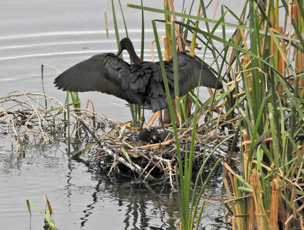
Here in the Berryessa Snow Mountain National Monument region, we have ibises, specifically white-faced ibises (Plegadis chihi), and even though they probably don’t maintain the universe, they do a good job of maintaining their little corners of the world.
Where the birds nest depends on the water levels in their favorite stomping grounds. White-Faced Ibises live in freshwater marshes, tule fields and even irrigated landscapes.
Here, in the early summer months, they gather together in loose-knit colonies (called “rookeries”), build their nests and have their babies. There are several of these rookeries around our region, including one within the city of Woodland.
At the rookeries, you can see that the ibises’ twiggy nests are built at various levels among the tules and shrubs. Nest placement can be a tricky business. If you build low, your nest is shaded by the nests above it, and you’re closer to the water, so the kiddies can step out of the nest and cool their feet if they get too warm.
But building low also means your nest is at the perfect height to get invaded by snakes, raccoons, and other marauders.
It’s not uncommon for garter snakes and even birds like the great-tailed grackle, to infiltrate the nests and eat the eggs and the babies.
At the Woodland rookery, I watched as a female great-tailed grackle tried to sneak in between the tules and behind the adult ibis standing on the nest to grab one of the newborn hatchlings. That seemed to be an uncommonly bold attempt at infanticide to me, but the ibis caught sight of grackle almost immediately and chased it off.
Being ibis parents means you’re on a 24-hour security detail. Usually, the females take the night shift and the males take the day shift.
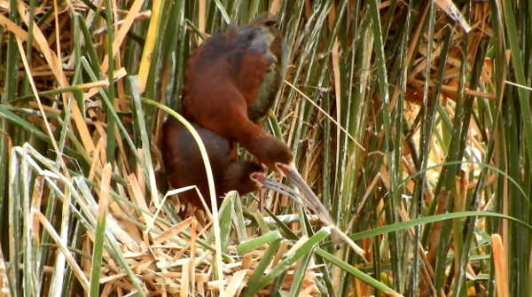
There’s also a problem with building the nests higher up in the tules and branches of low-lying trees, however. Those nests are then exposed to direct sunlight all day long, and that can be difficult for the summer-born babies who for the first several weeks of their lives can’t get out of the nest or move around much.
Parents in the upper nests often shade their offspring with their bodies and bring them fluids in the form of regurgitated water and food to keep them hydrated, but the heat can still take its toll. The summer’s heat might also play a factor in whether the birds will attempt to have a second brood before the season is over.
The ibises’ eggs are a bright turquoise blue so they’re easy to spot in the nests. Egg laying occurs in the morning hours, and usually the female will lay one egg, skip a day, then lay another egg, up to three or four. Sometimes younger females will lay eggs in more than one nest, so it’s hard to tell what egg actually belongs to whom without DNA testing, but the brooding parents don’t seem to care.
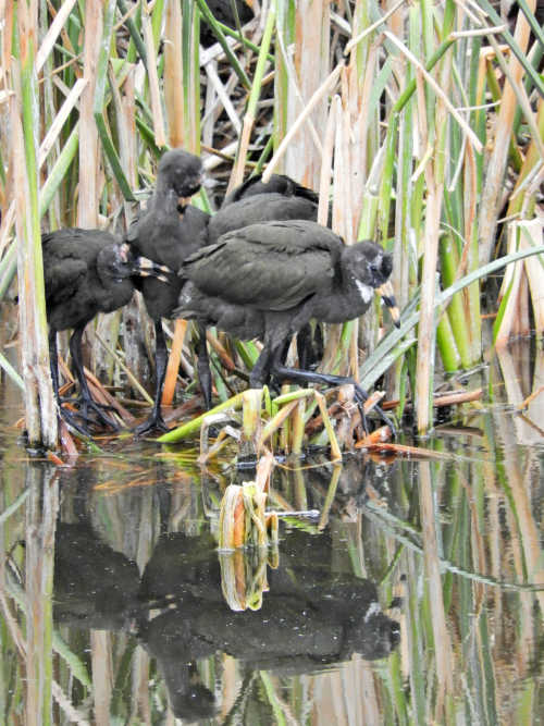
Both White-Faced Ibis parents, who look identical (except for the fact that the male is larger than the female), take turns incubating the eggs and feeding the hatchlings.
Whether the pairs mate for life is unknown, but some pairs seem to stay together through several breeding seasons. They generally eat a mixed diet of insects, worms, frogs and snails, leeches, spiders and crayfish.
It takes the youngsters about five weeks to go from hatching to being able to fly with the flock. When they’re young, the babies have dark bodies with a bald spot on the top of the head, and their dark beaks have pink, yellow or flesh-colored stripes on them.
As they mature, the head feathers fill in and the beak turns a sort of olive-gray. At a distance, mature birds may look black, but their true coloring shows itself off when the sunlight hits them at the right angle. Their plumage is actually a gorgeous mix of glossy, iridescent copper, purple and green. They get their name-sake white faces in the breeding season.
We see a lot of ibises in our region and that’s partly do to conservation efforts. In the past, the use of the pesticide DDT and the outright killing of the birds – a study in the 1960s showed that almost 83 percent of banded white-faced ibises in the state of Utah were shot by humans – were threatening to wipe the species out.
Since that time, DDT has been banned and the white-faced ibis was added to the Migratory Bird Treaty Act list to protect it. Right now, the species is doing fairly well.
The breeding season is almost over in our area, but if you still find nesting birds, please be careful not to disturb them.
When conditions are right, these birds can live for up to 14 years or more in the wild.
Mary K. Hanson is a Certified California Naturalist, author, nature photographer and blogger (https://chubbywomanwalkabout.com/). She also teaches naturalist classes through Tuleyome, a501(c)(3) nonprofit conservation organization based in Woodland. For more information, visit www.tuleyome.org.
UPPER LAKE, Calif. – The Mendocino Complex Disaster Recovery Center in Upper Lake is continuing to offer services to the community, and will have new hours beginning next week.
The center is located at the Habematolel Pomo of Upper Lake Tribal Community Center, 9460 Main St. in Upper Lake.
Starting on Monday, Aug. 27, the center will be open Monday to Saturday from 9 a.m. to 6 p.m. and closed on Sundays.
The disaster recovery center offers in-person support to individuals and business owners.
Recovery specialists from the Federal Emergency Management AGency, the U.S. Small Business Administration, and state and local agencies are available to provide assistance.
Individual Assistance is provided by FEMA directly to eligible individuals and families that have sustained losses due to the severe wildfires and winds beginning on July 23 in Lake and Shasta counties.
FEMA spokesman Thomas Kempton said activity has been brisk at the disaster recovery centers in both Lake and Shasta counties.
As of the close of business on Wednesday, for both Lake and Shasta Counties there were 3,117 registrations with 170 registrations on Tuesday alone, Kempton said.
FEMA has approved $3,705,550 for Individual and Households with the majority of those funds for housing assistance. Of that total amount $3,655,813 has already been disbursed to help residents recover from this disaster, according to Kempton.
Homeowners and renters in those two designated counties who sustained damage to their primary homes, vehicles and personal property may apply for disaster assistance.
Disaster assistance may include grants to help pay for temporary housing to include rental and lodging expense, emergency home repairs, uninsured and underinsured personal property losses, and compensation for medical or dental expenses caused by this disaster.
Disaster assistance from FEMA is a grant and does not have to be repaid. These FEMA grants are not taxable income and will not affect eligibility for Social Security, Medicaid, medical waiver programs, welfare assistance, Temporary Assistance for Needy Families, food stamps, Supplemental Security Income or Social Security Disability Insurance.
However funding from FEMA is limited.
FEMA is assisted in disaster recovery by the Small Business Administration. Don’t let the name confuse you because the SBA can offer loans to not only businesses of all sizes (including landlords), private nonprofit organizations, but also homeowners and renters.
Low-interest disaster loans can help fund repairs or rebuilding efforts and cover the cost of replacing lost or disaster-damaged real estate and personal property. Economic Injury disaster loans are available to business and private nonprofits to assist with working capital needs as a direct result of the disaster.
Survivors needing help may visit any disaster recovery center or call the FEMA Helpline at 800-621-3362 (Voice, 711 or VS) or 800-462-7585 (TTY). Helpline numbers are open from 7 a.m. to 11 p.m., seven days a week.