 How to resolve AdBlock issue?
News
LAKE COUNTY, Calif. – As Labor Day officially signals the end of summer, Cal Fire officials are encouraging Californians to be cautious with outdoor plans this weekend as wildfire risk remains high.
With millions of people taking advantage of the holiday weekend to visit beaches, parks, and campgrounds, we need everyone to be extra vigilant in preventing wildfires.
“This year we have seen not only the largest wildfire in California history, but the largest wildfire for 2018 across the United States,” said Chief Ken Pimlott, director of Cal Fire. “The past few months, our firefighters have been extremely busy with devastating, record-breaking wildfires. This year, Cal Fire has responded to 4,434 fires that burned 876,428 acres, compared to last year when we responded to 4,170 fires for 228,803 acres. Even though we will have near-normal temperatures this weekend, vegetation across the state is extremely dry and fall is when we typically see some of the most devastating fires.”
“We need everyone to be prepared ahead of time with our Ready, Set, Go! program that helps equip residents for a wildfire,” said Lynne Tolmachoff, Cal Fire chief of public education. “As 95 percent of our wildfires are human caused, the One Less Spark, One Less Wildfire Program stresses how to prevent wildfires through proper care and maintenance of campfires, vehicles, outdoor equipment and much more.”
So, what can you do to help prevent wildfires?
Vehicles:
– Never pull over and park in dry grass.
– Make sure your vehicle is properly maintained.
– When towing, ensure chains are not dragging on the ground.
– Check your tire pressure to avoid driving on an exposed metal rim.
Camping:
– Obtain a campfire permit and ALWAYS check for local fire restrictions.
– Keep a safe distance from dead trees to avoid falling branches and limbs.
– Avoid parking and setting up camp under or near dead trees.
– Be careful! Human activity causes 95 percent of wildfires.
– Clear away grass, leaves and other debris within a 10-foot perimeter of any campfire “Drown, stir and feel” to make sure a campfire is completely out.
– When barbequing, never leave the grill unattended.
Yardwork:
– Do all yardwork before 10 a.m. – avoid yardwork on hot, dry and windy days.
– Make sure you use the right tool for the job – lawnmowers are for cutting grass only.
Visit www.ReadyForWildfire.org to learn more about being prepared and for tips in reducing wildfire, visit www.PreventWildfireCA.org. Get ready for wildfire with the Cal Fire app. For current fire information, visit www.fire.ca.gov.
Earth recently experienced its largest annual increases in atmospheric carbon dioxide levels in at least 2,000 years.
Data from NASA’s Orbiting Carbon Observatory-2 (OCO-2), which launched in 2014, are helping scientists understand why.
Many factors go into improving long-term climate forecasting, including the study of how, how much, and where carbon dioxide (CO2) is absorbed and emitted by natural processes and human activities at different locations on Earth’s surface.
These exchanges vary from year to year, and scientists are using OCO-2 data to uncover the reasons.
Dr. Annmarie Eldering, Deputy Project Scientist for OCO-2 at NASA’s Jet Propulsion Laboratory explained: “We already knew that the global amount of carbon dioxide taken up and released by the land and ocean differs each year, and that often in El Niño years, more CO2 remains in the atmosphere. But this mission’s high-precision data on atmospheric CO2 across the globe have shown us, for the first time, how different regions contributed to this phenomenon and exactly what was driving the change.”
OCO-2 data for an El Niño event during 2015-2016 revealed that extra CO2 in the atmosphere at that time was caused by releases from South America, Africa and Indonesia.
Eldering said, “We saw that each of these regions released more carbon for slightly different reasons – different combinations of increased temperatures, less rain, or more fires.”
Not all of the carbon dioxide emitted into Earth’s atmosphere stays there. Some of the CO2 is absorbed by Earth’s oceans. Natural land sinks also absorb CO2, but the amounts of CO2 taken up at different locations on Earth’s surface are not well understood.
Eldering asked: “As carbon dioxide continues to build up, will the land and ocean continue absorbing it? Will natural processes reach a saturation point or will they keep taking up more and more?”
The many and varied uses of OCO-2 data will continue to be essential to understanding the dynamics of carbon dioxide across our planet, and will help contribute to improved long-term climate forecasting.
For more intriguing discoveries about our changing planet, stay tuned to http://science.nasa.gov.
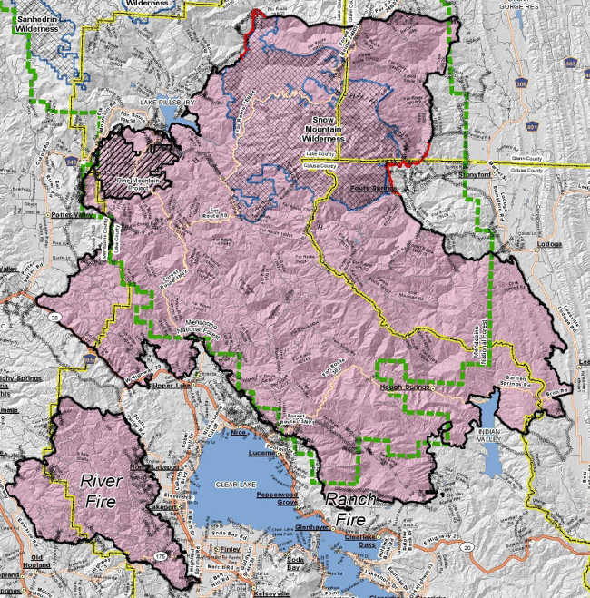
LAKE COUNTY, Calif. – Firefighters continue to strengthen lines around the Mendocino Complex in an effort to have the incident fully contained this weekend.
The Mendocino Complex remained at 459,102 acres and 93 percent containment as of Friday morning, according to the U.S. Forest Service.
The Ranch fire is still at 410,182 acres and 93 percent containment, officials said. The River five was fully contained earlier this month at 48,920 acres.
It’s expected the complex will be fully contained on Saturday, fire officials said.
The United States Department of Agriculture Forest Service and California Interagency Incident Management Team 3 under Incident Commander Mark von Tillow, which is managing the complex, said 1,494 personnel, 56 engines, 39 hand crews, three helicopters and 25 dozers remain assigned to the incident.
The team’s Friday reports said two areas of the Ranch Fire remain the highest priority for suppression operations.
On Friday, officials said firefighters monitored burning vegetation inside the perimeter of the fire and extinguished hot spots along firelines near Little Round Mountain in the north and around Fouts Springs west of Stonyford.
The critical work of suppression repair to firelines constructed over the past month continues in all parts of the Ranch fire, the report said
Friday’s map of the fire showed that there are two areas of uncontrolled fire edge, noted on the map in red – one is north of Fouts Springs, from northern Colusa into southern Glenn County, and the other is to the northeast of Lake Pillsbury.
Hazy skies with moderate to light smoke impacts are expected Saturday. Officials said lingering smoke will move lower to the ground in the late morning as the inversion breaks. This will bring moderate smoke levels to communities closest to the fire such as Potter Valley, Stonyford/Elk Creek, the Clear Lake area and possibly Ukiah.
Light west and north winds will drift haze over regional zones east and south over the southern Sacramento Valley where light to moderate smoke impacts are expected, according to the Forest Service.
A smoke forecast can be found here: https://wildlandfiresmoke.net/outlooks/MendocinoNationalForest-SacramentoValleyArea.
Forest officials said Forest Order No. 08-18-14, covering the southern part of the Mendocino National Forest, remains in effect. All roads and areas described within the order remain closed to the general public. Homeowners with proof of residency are permitted to access their property within the closure area.
The northern half of the Mendocino National Forest remains open and can be accessed via Forest Highway 7.
The forest areas around Plaskett Meadows and Hammerhorn Lake are open for recreation activities. The Yolla Bolly-Middle Eel Wilderness is also open for recreation, forest officials reported.

LAKE COUNTY, Calif. – Authorities said that they have located and recovered what evidence so far suggests is the body of a woman who was reported missing from Lake County nearly two months ago.
The Ford Crown Victoria belonging to Kelseyville resident Sharon Foley, along with human remains, was discovered earlier this week on private property in a remote, forested area of Sierra County, according to Sgt. Mike Fisher of the Sierra County Sheriff’s Office.
A family member reported Foley, 67, missing to the Lake County Sheriff’s Office on July 9, six days after she was last seen.
She also had gone missing for a few days in early May but was quickly located, as Lake County News has reported.
When she was reported missing in July, the Lake County Sheriff’s Office said she suffered from depression and bipolar disorder and hadn’t been taking her medications, and that she couldn’t walk on her own, but could drive a vehicle.
Lt. Corey Paulich of the Lake County Sheriff’s Office told Lake County News that on Monday the agency was notified by the Sierra County Sheriff’s Office that a deceased female believed to be Foley was located in a rural area of that county.
Fisher, the supervising sergeant on the investigation as well as Sierra County’s sheriff-elect, said that on Monday afternoon the Sierra County Sheriff’s Office was contacted by a forester who had been doing some work on a remote piece of property in that county’s western portion.
The forester came across a white Ford Crown Victoria and thought it was suspicious. When he approached the vehicle, he found what he believed to be human remains, Fisher said.
With there being no cell service, the forester went to get the property owner and together the two of them went to find an area of cell coverage to call authorities, according to Fisher.
Fisher said he and two deputies responded out to the location, which he said is about a 40-minute drive on dirt roads to the east of Camptonville, the closest town, located in neighboring Yuba County.
Once on scene, Fisher said they were able to confirm that the vehicle was Foley’s 2009 Ford Crown Victoria – the same vehicle in which the Lake County Sheriff’s Office said she had left her home on July 3 – and matched the license plate, 6FYP475.
During their subsequent investigation of the scene, Fisher said they located human remains.
“We believe it to be that of Sharon Foley but we have not made positive identification,” he said.
Fisher said they don’t believe there was foul play. Rather, it appears that Foley’s car became stuck and she succumbed to the elements. She had been dead for some time, he added.
He said it appeared that Foley had traveled a series of Forest Service roads before turning off onto the private property.
“We run into this a little more in the winter time,” he said, noting that one of the area’s main highways on its far east side is Interstate 80 between Truckee and Reno. In those cases, if there is a highway closure, people can get off course when their GPS directs them to alternate routes through remote territory.
But that didn’t appear to be the case here, with there being no sign of a GPS, he said.
The vehicle was found on an unmaintained road that the property owner doesn’t often travel, Fisher said.
In examining the car, Fisher said Foley did not have her wheelchair with her, which she needed because she couldn’t walk. She also didn’t have a cell phone. Without the ability to walk out or to signal for help, Foley was trapped.
Fisher said the car was open, and the remains appeared to have been disturbed by animals.
The remains were sent to the Placer County Medical Examiner’s office for an autopsy. Fisher said they will essentially catalog what was recovered and collect DNA samples to confirm the identity.
The car also was removed from the scene, he said.
Fisher said Foley’s family has been notified of the discovery.
While they haven’t so far positively identified the individual, “Based on the evidence at scene, we were confident enough to give the family some closure,” Fisher said.
He said it may take another month to get DNA results back from the California Department of Justice.
If there is a delay, they will consult a forensic odontologist in the Bay Area, who will use dental records for the identification, he said.
Email Elizabeth Larson at
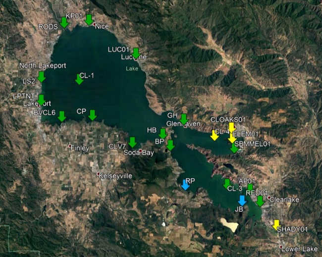
LAKE COUNTY, Calif. – Lake County Public Health reported that the latest round of testing for blue-green algae cyanotoxins on Clear Lake has resulted in “caution” levels for several areas.
Officials said current cyanotoxin results for lakewide sampling conducted Aug. 15 and Aug. 21 – which results received on Aug. 29 – detected microcystin at 12 of 21 sampled sites.
Four of those sites resulted in caution trigger levels: the center of the Oaks Arm, Clearlake Oaks shoreline, Elem shoreline and Cache Creek at Highway 53.
The remaining sites do not reach any trigger levels, were nondetect for toxins, or were not sampled due to being inaccessible, official said.
The next monitoring event will be Sept. 10.
This week's reading are lower than previously, but two consecutive improved readings are needed before the county can change the level of alert for cyanobacteria that went out on Aug. 10.
Be aware that you will see signs for a higher level – for example, danger instead of caution – until there are two readings at the lower level. Public Health also needs two consecutive nondetect readings before they remove signs.
Blue-green algae can pose health risks, particularly to children and pets. Local health officials urge people to choose safe activities when visiting the Oaks Arm and parts of the Lower Arm of Clear Lake and wherever blooms are visible.
It is strongly recommended that people and their pets avoid contact with water and avoid swallowing lake water in an algae bloom area.
Public Health recommends following the below from the statewide guidance on cyanobacteria and harmful algal blooms:
• Take care that pets and livestock do not drink the water, swim through algae, scums or mats, or lick their fur after going in the water. Rinse pets in clean water to remove algae from fur.
• Avoid wading, swimming, jet or water skiing in water containing algae blooms, scums or mats.
• Do not drink, cook or wash dishes with untreated surface water from these areas under any circumstances; common water purification techniques such as camping filters, tablets and boiling do not remove toxins.
• People should not eat mussels or other bivalves collected from these areas. Limit or avoid eating fish from these areas; if fish are consumed, remove the guts and liver, and rinse filets in clean drinking water.
• Get medical treatment immediately if you think that you, your pet, or livestock might have been poisoned by blue-green algae toxins. Be sure to alert the medical professional to the possible contact with blue-green algae. Also, make sure to contact the local county public health department at 707-263-1090.
As destructive wildfires continue to burn throughout California, the California Board of Forestry and Fire Protection took action last week in adoption of the 2018 Strategic Fire Plan.
The Strategic Fire Plan for California is the state’s road map for reducing the risk and impacts from wildland fires.
“We continue to experience large and damaging wildfires across our state and must work to break the cycle,” said J. Keith Gilless, chair of the California Board of Forestry and Fire Protection. “This plan addresses the need for continued efforts to prevent wildfire, while considering recent climate considerations like drought and tree mortality.”
The plan update was developed over the past 21-months in a collaborative effort between the Board, Cal Fire, stakeholders and public input.
“Significant effort went into the development of this plan, and now we have updated policy to guide us through current and future fire seasons,” said Chief Ken Pimlott, Cal Fire director.
The Strategic Fire Plan places an emphasis on what needs to be done long before a fire starts, while also looking to reduce firefighting costs, property losses, increasing firefighter safety, and contributing to forest health.
The 2018 Strategic Fire Plan has seven goals that include: analyzing the fire risk, supporting land use planning, community preparedness planning, public education, integrating landowner fuels management, identifying fire suppression resources, increasing fire prevention efforts and post wildfire recovery.
Since the last iteration of the Strategic Fire Plan in 2010, it appears that the impacts of climate change has resulted in increased severity of wildfires, longer fire seasons, increased extreme weather conditions, historic drought, and led to our state’s worst tree mortality epidemic in history.
The 2018 Strategic Fire Plan addresses these issues and highlights the need for heightened levels of fire prevention and protection of natural resources.
“The 2010 Fire Plan served us well in navigating one of California’s worst droughts,” said Chief Daniel Berlant, Cal Fire assistant deputy director and co-chair of the Fire Plan Steering Committee. “This new plan will continue to provide us a framework to reduce California’s growing wildfire risk.”
The State’s Strategic Fire Plan is updated every eight to 10 years.
Annually, Cal Fire provides an update to the board to report on the progress in plan implementation and on successes, as well as challenges.
Each Cal Fire Unit and Contract County develop local fire plans based on the guidance provided in the 2018 Strategic Fire Plan.
The 2018 Strategic Fire Plan is available on the board’s Web site at http://www.bof.fire.ca.gov/.