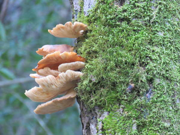
Polypores or bracket fungi growing on a tree. Photo by Kathleen Scavone.
“Those who contemplate the beauty of the earth find reserves of strength that will endure as long as life lasts. There is something infinitely healing in the repeated refrains of nature – the assurance that dawn comes after night, and spring after winter.”– Rachel Carson
LAKE COUNTY, Calif. – After a fall or winter storm it's safe to say that mushroom bodies or fungi of all description begin to push up from the land down under.
All that is needed is adequate moisture and then some life-giving sunshine, and viola! They appear as if by magic.
Since mushroom species typically thrive in certain habitats you are likely to see boletes, russulas and chanterelles under or near oak species, while oyster mushrooms prefer maples and alders near creeks.
While walking about an environment which includes mushrooms maturing under madrones and manzanitas, you are witnessing a mycorrhizal fungi that forms a unique partnership with those particular trees.
Some fungi form only under Douglas firs, while many other species are not so fickle and are found in a myriad of other places.
Although we can't always see them, mushrooms are present at all times, sheltered under the soil, or concealed beneath a tree's bark. Some, like bracket fungi are highly visible, and form ladders, ascending a dead tree trunk, while others play hide-and-seek with leaf matter in the woods.
Mushrooms are one of nature's necessary scavengers, breaking down and decomposing fallen leaf, tree and other forest matter, and thrive with their symbiotic relationships to plants and other mushrooms.
Mushrooms quietly go about the business of breaking down matter then recycling nutrients back into the ecosystem.
According to Dr. Dennis E. Desjardin, author and professor of mycology at San Francisco State University as well as scientific advisor to the Mycological Society of San Francisco, "In technical terms, mushrooms are the charismatic sexual reproductive structures of fungal individuals whose main body (fine, cobweb-like filaments called hyphae) is well hidden in the soil or amongst leaves and rotting wood. The primary role of the mushroom is reproduction- abundant spore production and effective spore dispersal- and its shape reflects this function."
Fungi are veritable living paradoxes, containing the strength to push up through the soil, while at the same time being comprised of such delicate tissue. Some fungi, like the puffball, are beautifully spherical, white wonders, while others, like Western jack-o’-lantern mushrooms (Omphalotus olivascens) are bioluminescent and glow in the dark!
Mushrooms vary in structure: Most have gills – those delicate, plate-like structures that fan out beneath a mushroom like pages in a book.
Gilled mushrooms are usually described within five main groups that include tiny gilled mushrooms ( less than two inches in height), veiled fungi with free gills (their gills are not attached to the stalk, or a very small portion of the gills are attached), veiled mushrooms (those which grow with attached gills), fungi with free gills ( they do not contain any attached gills, instead the gills are all free from the stalk), and mushrooms with attached gills (the gills grow to the stalks).
Mushrooms are comprised of roots, a base, stalk, gills, ring and a cap.
Given that mushroom identification is challenging, it is best to leave it to the experts to determine the edible varieties.
The study of mushrooms, or mycology, is growing quickly with the advent of DNA sequencing data, and the experts are adding newfound information to mushroom field guides annually.
The edible mushrooms that you often find in the supermarket are quite nutritious, containing protein, carbs, both B and D vitamins, as well as phosphorus and zinc.
Culturally, the intense knowledge of edible and poisonous mushrooms has been studied, and has been important throughout history: for food, medicine and spiritual purposes.
The silent, strong and mysterious mushroom has also been used for fire-building tinder, decoration and in the production of leather-like clothing.
Mushrooms are used to create dyes as well. For example puffballs create a red dye, meadow mushrooms are known for their yellow-green dyes, while the chanterelle mushroom creates a yellow dye.
Kathleen Scavone is a writer and retired teacher. She lives in Middletown, Calif.
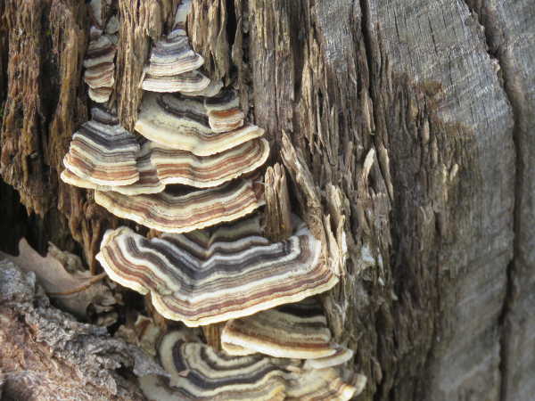
Turkey tail can be found on stumps throughout the year. Photo by Kathleen Scavone.
LAKE COUNTY, Calif. – Lake County Animal Care and Control’s kennels are filled with dogs this week waiting for new homes.
Dogs available for adoption this week include mixes of Akbash, bluetick coonhound, Chihuahua, Great Pyrenees, pit bull, shepherd, Staffordshire bull terrier and terrier.
Dogs that are adopted from Lake County Animal Care and Control are either neutered or spayed, microchipped and, if old enough, given a rabies shot and county license before being released to their new owner. License fees do not apply to residents of the cities of Lakeport or Clearlake.
If you're looking for a new companion, visit the shelter. There are many great pets hoping you'll choose them.
The following dogs at the Lake County Animal Care and Control shelter have been cleared for adoption (additional dogs on the animal control Web site not listed are still “on hold”).
This female Chihuahua-terrier mix is in kennel No. 3b, ID No. 11936. Photo courtesy of Lake County Animal Care and Control. Chihuahua-terrier mix
This female Chihuahua-terrier mix has a short brown and white coat.
She already has been spayed.
She’s in kennel No. 3b, ID No. 11936.
This female Chihuahua is in kennel No. 6, ID No. 11942. Photo courtesy of Lake County Animal Care and Control. Female Chihuahua
This female Chihuahua has a short fawn and white coat.
She already has been spayed.
She’s in kennel No. 6, ID No. 11942.
“Jaelyn” is a female Chihuahua in kennel No. 9, ID No. 11861. Photo courtesy of Lake County Animal Care and Control. ‘Jaelyn’
“Jaelyn” is a female Chihuahua with a short tan coat.
She already has been spayed.
She’s in kennel No. 9, ID No. 11861.
“JessJess” is a male Chihuahua in kennel No. 9, ID No. 11862. Photo courtesy of Lake County Animal Care and Control. ‘JessJess’
“JessJess” is a male Chihuahua with a short tan coat.
He’s already been neutered.
He’s in kennel No. 9, ID No. 11862.
“Rio” is a male bluetick coonhound-shepherd mix in kennel No. 11, ID No. 11947. Photo courtesy of Lake County Animal Care and Control. ‘Rio’
“Rio” is a male bluetick coonhound-shepherd mix with a short tricolor coat.
He already has been neutered.
He’s in kennel No. 11, ID No. 11947.
“Sarra” is a female Akbash in kennel No. 12, ID No. 11855. Photo courtesy of Lake County Animal Care and Control. ‘Sarra’
“Sarra” is a female Akbash with a medium-length white coat and green eyes.
Shelter staff said she should go to a home with no cats, small dogs or livestock.
She’s in kennel No. 12, ID No. 11855.
“Baylee” is a female pit bull terrier in kennel No. 14, ID No. 11892. Photo courtesy of Lake County Animal Care and Control. ‘Baylee’
“Baylee” is a female pit bull terrier has a short brindle and white coat.
Shelter staff said she is good with other dogs, has lived with cats and chickens, and was raised with children.
She already has been spayed.
She’s in kennel No. 14, ID No. 11892.
“Maebelle” is a female pit bull terrier in kennel No. 15, ID No. 11893. Photo courtesy of Lake County Animal Care and Control. ‘Maebelle’
“Maebelle” is a female pit bull terrier with a short brindle and white coat.
Shelter staff said she is good with other dogs, has lived with cats and chickens, and was raised with a small child.
She’s in kennel No. 15, ID No. 11893.
This male Staffordshire Bull Terrier is in kennel No. 17, ID No. 11943. Photo courtesy of Lake County Animal Care and Control. Male Staffordshire Bull Terrier
This male Staffordshire Bull Terrier has a short buff, white and brown coat.
He’s in kennel No. 17, ID No. 11943.
“Bobby Socks” is a female Staffordshire bull terrier-Rhodesian Ridgeback in kennel No. 21, ID No. 11911. Photo courtesy of Lake County Animal Care and Control. ‘Bobby Socks’
“Bobby Socks” is a female Staffordshire bull terrier-Rhodesian Ridgeback.
She has a short red coat and has already been spayed.
She’s in kennel No. 21, ID No. 11911.
This female pit bull terrier-boxer mix is in kennel No. 22, ID No. 11950. Photo courtesy of Lake County Animal Care and Control. Pit bull terrier
This female pit bull terrier has a short brown and white coat.
She’s in kennel No. 22, ID No. 11950.
This male pit bull terrier is in kennel No. 23, ID No. 11941. Photo courtesy of Lake County Animal Care and Control. Male pit bull terrier
This male pit bull terrier has a short black coat.
He’s in kennel No. 23, ID No. 11941.
“Little Foot” is a white male Great Pyrenees is in kennel No. 27, ID No. 11854. Photo courtesy of Lake County Animal Care and Control. ‘Little Foot’
“Little Foot” is a white male Great Pyrenees with a long white coat and gold eyes.
Shelter staff said the right home for him will not have cats, small dogs or livestock.
He’s in kennel No. 27, ID No. 11854.
Lake County Animal Care and Control is located at 4949 Helbush in Lakeport, next to the Hill Road Correctional Facility.
Office hours are Monday through Friday, 11 a.m. to 5 p.m., and 11 a.m. to 3 p.m., Saturday. The shelter is open from 11 a.m. to 4 p.m. Monday through Friday and on Saturday from 11 a.m. to 3 p.m.
For more information call Lake County Animal Care and Control at 707-263-0278.
Email Elizabeth Larson at This email address is being protected from spambots. You need JavaScript enabled to view it.. Follow her on Twitter, @ERLarson, or Lake County News, @LakeCoNews.
Weapons and drug paraphernalia seized by the Clearlake Police Department during a traffic stop on Friday, March 29, 2019. Photo courtesy of the Clearlake Police Department. CLEARLAKE, Calif. – A Clearlake man was arrested Friday after a police officer found him in possession of a loaded gun and drugs during a traffic stop.
Kevin Daniel Berentis, 37, was taken into custody shortly before 2 a.m. on Friday, according to Lake County Jail booking records and a report from the Clearlake Police Department.
Officer Mauricio Barreto conducted the stop, finding Berentis in possession of a .22-caliber rifle in the back seat of his pickup and had a loaded 9 millimeter handgun concealed on his person, police said.
The agency said Berentis also was found to be in possession of suspected methamphetamine and drug paraphernalia.
Berentis was booked into the Lake County Jail for several firearms related charges including concealed weapon on his person and in his vehicle, carrying a loaded firearm, possession of a firearm and ammunition by a prohibited person along with drug related charges, police said.
Jail records indicated Berentis remained in custody on Sunday, with bail set at $50,000.
He’s tentatively scheduled to appear in court on Tuesday, based on his booking record.
Kevin Daniel Berentis, 37, of Clearlake, Calif., was arrested on Friday, March 29, 2019, following a traffic stop. Lake County Jail photo.
A meteor impact 66 million years ago generated a tsunami-like wave in an inland sea that killed and buried fish, mammals, insects and a dinosaur, the first victims of a cataclysm that led to Earth’s last mass extinction. The death scene from within an hour of the impact has been excavated at an unprecedented fossil site in North Dakota. Graphics courtesy of Robert DePalma. BERKELEY, Calif. – The beginning of the end started with violent shaking that raised giant waves in the waters of an inland sea in what is now North Dakota.
Then, tiny glass beads began to fall like birdshot from the heavens. The rain of glass was so heavy it may have set fire to much of the vegetation on land. In the water, fish struggled to breathe as the beads clogged their gills.
The heaving sea turned into a 30-foot wall of water when it reached the mouth of a river, tossing hundreds, if not thousands, of fresh-water fish – sturgeon and paddlefish – onto a sand bar and temporarily reversing the flow of the river.
Stranded by the receding water, the fish were pelted by glass beads up to 5 millimeters in diameter, some burying themselves inches deep in the mud.
The torrent of rocks, like fine sand, and small glass beads continued for another 10 to 20 minutes before a second large wave inundated the shore and covered the fish with gravel, sand and fine sediment, sealing them from the world for 66 million years.
This unique, fossilized graveyard – fish stacked one atop another and mixed in with burned tree trunks, conifer branches, dead mammals, mosasaur bones, insects, the partial carcass of a Triceratops, marine microorganisms called dinoflagellates and snail-like marine cephalopods called ammonites – was unearthed by paleontologist Robert DePalma over the past six years in the Hell Creek Formation, not far from Bowman, North Dakota.
The evidence confirms a suspicion that nagged at DePalma in his first digging season during the summer of 2013 – that this was a killing field laid down soon after the asteroid impact that eventually led to the extinction of all ground-dwelling dinosaurs. The impact at the end of the Cretaceous Period, the so-called K-T boundary, exterminated 75 percent of life on Earth.
"This is the first mass death assemblage of large organisms anyone has found associated with the K-T boundary," said DePalma, curator of paleontology at the Palm Beach Museum of Natural History in Florida and a doctoral student at the University of Kansas. "At no other K-T boundary section on Earth can you find such a collection consisting of a large number of species representing different ages of organisms and different stages of life, all of which died at the same time, on the same day."
In a paper to appear this week in the journal Proceedings of the National Academy of Sciences, he and his American and European colleagues, including two University of California, Berkeley, geologists, describe the site, dubbed Tanis, and the evidence connecting it with the asteroid or comet strike off Mexico's Yucatan Peninsula 66 million years ago.
That impact created a huge crater, called Chicxulub, in the ocean floor and sent vaporized rock and cubic miles of asteroid dust into the atmosphere. The cloud eventually enveloped Earth, setting the stage for Earth’s last mass extinction.
"It's like a museum of the end of the Cretaceous in a layer a meter-and-a-half thick," said Mark Richards, a UC Berkeley professor emeritus of earth and planetary science who is now provost and professor of earth and space sciences at the University of Washington.
Richards and Walter Alvarez, a UC Berkeley Professor of the Graduate School who 40 years ago first hypothesized that a comet or asteroid impact caused the mass extinction, were called in by DePalma and Dutch scientist Jan Smit to consult on the rain of glass beads and the tsunami-like waves that buried and preserved the fish. The beads, called tektites, formed in the atmosphere from rock melted by the impact.
Tsunami vs. seiche
Richards and Alvarez determined that the fish could not have been stranded and then buried by a typical tsunami, a single wave that would have reached this previously unknown arm of the Western Interior Seaway no less than 10 to 12 hours after the impact 3,000 kilometers away, if it didn’t peter out before then. Their reasoning: The tektites would have rained down within 45 minutes to an hour of the impact, unable to create mudholes if the seabed had not already been exposed.
Instead, they argue, seismic waves likely arrived within 10 minutes of the impact from what would have been the equivalent of a magnitude 10 or 11 earthquake, creating a seiche (pronounced saysh), a standing wave, in the inland sea that is similar to water sloshing in a bathtub during an earthquake.
Though large earthquakes often generate seiches in enclosed bodies of water, they're seldom noticed, Richards said. The 2011 Tohoku quake in Japan, a magnitude 9.0, created six-foot-high seiches 30 minutes later in a Norwegian fjord 8,000 kilometers away.
"The seismic waves start arising within nine to 10 minutes of the impact, so they had a chance to get the water sloshing before all the spherules (small spheres) had fallen out of the sky," Richards said. "These spherules coming in cratered the surface, making funnels – you can see the deformed layers in what used to be soft mud – and then rubble covered the spherules. No one has seen these funnels before."
The tektites would have come in on a ballistic trajectory from space, reaching terminal velocities of between 100 and 200 miles per hour, according to Alvarez, who estimated their travel time decades ago.
"You can imagine standing there being pelted by these glass spherules. They could have killed you," Richards said. Many believe that the rain of debris was so intense that the energy ignited wildfires over the entire American continent, if not around the world.
"Tsunamis from the Chicxulub impact are certainly well-documented, but no one knew how far something like that would go into an inland sea," DePalma said. "When Mark came aboard, he discovered a remarkable artifact – that the incoming seismic waves from the impact site would have arrived at just about the same time as the atmospheric travel time of the ejecta. That was our big breakthrough."
At least two huge seiches inundated the land, perhaps 20 minutes apart, leaving six feet of deposits covering the fossils. Overlaying this is a layer of clay rich in iridium, a metal rare on Earth, but common in asteroids and comets. This layer is known as the K-T, or K-Pg boundary, marking the end of the Cretaceous Period and the beginning of the Tertiary Period, or Paleogene.
Iridium
In 1979, Alvarez and his father, Nobelist Luis Alvarez of UC Berkeley, were the first to recognize the significance of iridium that is found in 66 million-year-old rock layers around the world. They proposed that a comet or asteroid impact was responsible for both the iridium at the K-T boundary and the mass extinction.
The impact would have melted the bedrock under the seafloor and pulverized the asteroid, sending dust and melted rock into the stratosphere, where winds would have carried them around the planet and blotted out the sun for months, if not years. Debris would have rained down from the sky: not only tektites, but also rock debris from the continental crust, including shocked quartz, whose crystal structure was deformed by the impact.
The iridium-rich dust from the pulverized meteor would have been the last to fall out of the atmosphere after the impact, capping off the Cretaceous.
"When we proposed the impact hypothesis to explain the great extinction, it was based just on finding an anomalous concentration of iridium – the fingerprint of an asteroid or comet," said Alvarez. "Since then, the evidence has gradually built up. But it never crossed my mind that we would find a deathbed like this."
Key confirmation of the meteor hypothesis was the discovery of a buried impact crater, Chicxulub, in the Caribbean and off the coast of the Yucatan in Mexico, that was dated to exactly the age of the extinction. Shocked quartz and glass spherules were also found in K-Pg layers worldwide. The new discovery at Tanis is the first time the debris produced in the impact was found along with animals killed in the immediate aftermath of the impact.
"And now we have this magnificent and completely unexpected site that Robert DePalma is excavating in North Dakota, which is so rich in detailed information about what happened as a result of the impact," Alvarez said. "For me, it is very exciting and gratifying!"
Tektites
Jan Smit, a retired professor of sedimentary geology from Vrije Universiteit in Amsterdam in The Netherlands who is considered the world expert on tektites from the impact, joined DePalma to analyze and date the tektites from the Tanis site. Many were found in near perfect condition embedded in amber, which at the time was pliable pine pitch.
"I went to the site in 2015 and, in front of my eyes, he (DePalma) uncovered a charred log or tree trunk about four meters long which was covered in amber, which acted as sort of an aerogel and caught the tektites when they were coming down," Smit said. "It was a major discovery, because the resin, the amber, covered the tektites completely, and they are the most unaltered tektites I have seen so far, not 1 percent of alteration. We dated them, and they came out to be exactly from the K-T boundary."
The tektites in the fishes’ gills are also a first.
"Paddlefish swim through the water with their mouths open, gaping, and in this net, they catch tiny particles, food particles, in their gill rakers, and then they swallow, like a whale shark or a baleen whale," Smit said. "They also caught tektites. That by itself is an amazing fact. That means that the first direct victims of the impact are these accumulations of fishes."
Smit also noted that the buried body of a Triceratops and a duck-billed hadrosaur proves beyond a doubt that dinosaurs were still alive at the time of the impact.
"We have an amazing array of discoveries which will prove in the future to be even more valuable," Smit said. "We have fantastic deposits that need to be studied from all different viewpoints. And I think we can unravel the sequence of incoming ejecta from the Chicxulub impact in great detail, which we would never have been able to do with all the other deposits around the Gulf of Mexico."
"So far, we have gone 40 years before something like this turned up that may very well be unique," Smit said. "So, we have to be very careful with that place, how we dig it up and learn from it. This is a great gift at the end of my career. Walter sees it as the same."
Co-authors with DePalma, Smit, Richards and Alvarez are David Burnham of the University of Kansas, Klaudia Kuiper of Vrije Universiteit, Phillip Manning of Manchester University in the United Kingdom, Anton Oleinik of Florida Atlantic University, Peter Larson of the Black Hills Institute of Geological Research in South Dakota, Florentin Maurrasse of Florida International University, Johan Vellekoop of Katholieke Universiteit Leuven in Belgium and Loren Gurche of the Palm Beach Museum of Natural History.
Robert Sanders writes for the UC Berkeley News Center.
NASA research shows that Jakobshavn Glacier, which has been Greenland's fastest-flowing and fastest-thinning glacier for the last 20 years, has made an unexpected about-face.
Jakobshavn is now flowing more slowly, thickening, and advancing toward the ocean instead of retreating farther inland. The glacier is still adding to global sea level rise – it continues to lose more ice to the ocean than it gains from snow accumulation – but at a slower rate.
The researchers conclude that the slowdown of this glacier, known in the Greenlandic language as Sermeq Kujalleq, occurred because an ocean current that brings water to the glacier's ocean face grew much cooler in 2016. Water temperatures in the vicinity of the glacier are now colder than they have been since the mid-1980s.
In a study published in Nature Geoscience, Ala Khazendar of NASA's Jet Propulsion Laboratory in Pasadena, California, and colleagues report the change in Jakobshavn's behavior and trace the source of the cooler water to the North Atlantic Ocean more than 600 miles (966 kilometers) south of the glacier.
The research is based on data from NASA's Oceans Melting Greenland, or OMG, mission and other observations.
The scientists were so shocked to find the change, Khazendar said: "At first we didn't believe it. We had pretty much assumed that Jakobshavn would just keep going on as it had over the last 20 years."
However, the OMG mission has recorded cold water near Jakobshavn for three years in a row.
The researchers suspect the cold water was set in motion by a climate pattern called the North Atlantic Oscillation, or NAO, which causes the northern Atlantic Ocean to switch slowly between warm and cold every five to 20 years.
The climate pattern settled into a new phase recently, cooling the Atlantic in general. This change was accompanied by some extra cooling in 2016 of the waters along Greenland's southwest coast, which flowed up the west coast, eventually reaching Jakobshavn.
When the climate pattern flips again, Jakobshavn will most likely start accelerating and thinning again.
Josh Willis of JPL, the principal investigator of OMG, explained, "Jakobshavn is getting a temporary break from this climate pattern. But in the long run, the oceans are warming. And seeing the oceans have such a huge impact on the glaciers is bad news for Greenland's ice sheet."
Water temperature and weather
Jakobshavn, located on Greenland's west coast, drains about 7 percent of the island's ice sheet. Because of its size and importance to sea level rise, scientists from NASA and other institutions have been observing it for many years.
Researchers hypothesized that the rapid retreat of the glacier began with the early 2000s loss of the glacier's ice shelf – a floating extension of the glacier that slows its flow. When ice shelves disintegrate, glaciers often speed up in response.
Jakobshavn has been accelerating each year since losing its ice shelf, and its front (where the ice reaches the ocean) has been retreating. It lost so much ice between 2003 and 2016 that its thickness, top to bottom, shrank by 500 feet (152 meters).
The research team combined earlier data on ocean temperature with data from the OMG mission, which has measured ocean temperature and salinity around the entire island for the last three summers. They found that in 2016, water in Jakobshavn's fjord cooled to temperatures not seen since the 1980s.
"Tracing the origin of the cold waters in front of Jakobshavn was a challenge," explained Ian Fenty of JPL, a co-author of the study. "There are enough observations to see the cooling but not really enough to figure out where it came from."
Using an ocean model called Estimating the Circulation and Climate of the Ocean, or ECCO, to help fill in the gaps, the team traced the cool water upstream (toward the south) to a current that carries water around the southern tip of Greenland and northward along its west coast. In 2016, the water in this current cooled by more than 2.7 degrees Fahrenheit (1.5 degrees Celsius).
Although the last few winters were relatively mild in Greenland itself, they were much colder and windier than usual over the North Atlantic Ocean. The cold weather coincided with the switch in the NAO climate pattern.
Under the influence of this change, the Atlantic Ocean near Greenland cooled by about 0.5 degrees Fahrenheit (1 degree Celsius) between 2013 and 2016. These generally cooler conditions set the stage for the rapid cooling of the ocean current in southwest Greenland in early 2016. The cooler waters arrived near Jakobshavn that summer, at the same time that Jakobshavn slowed dramatically.
The team suspects that both the widespread Atlantic cooling and the dramatic cooling of the waters that reached the glacier were driven by the shift in the NAO. If so, the cooling is temporary and warm waters will return when the NAO shifts to a warm phase once again.
Wider implications
The warming climate has increased the risk of melting for all land ice worldwide, but many factors can speed or slow the rate of ice loss.
"For example," Khazendar said, "the shape of the bed under a glacier is very important, but it is not destiny. We've shown that ocean temperatures can be just as important."
Tom Wagner, NASA Headquarters program scientist for the cryosphere, who was not involved in the study, said, "The OMG mission deployed new technologies that allowed us to observe a natural experiment, much as we would do in a laboratory, where variations in ocean temperatures were used to control the flow of a glacier. Their findings – especially about how quickly the ice responds – will be important to projecting sea level rise in both the near and distant future."
The paper on the new research in Nature Geoscience is titled "Jakobshavn's 20 Years of Acceleration and Thinning Interrupted by Regional Ocean Cooling." Besides JPL, co-authors are at Remote Sensing Solutions in Barnstable, Massachusetts, and the University of Utrecht in the Netherlands.
Carol Rasmussen is a member of NASA's Earth Science News Team.
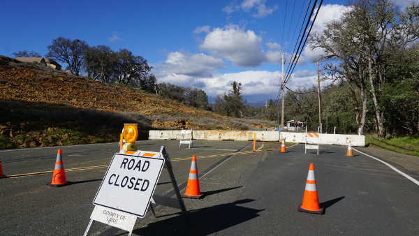
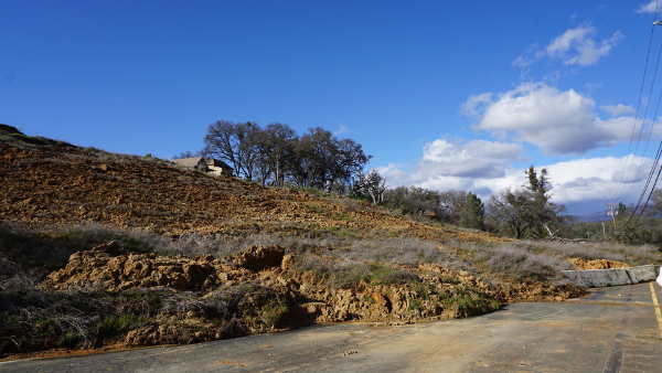
The area of Hill Road near the Lakeside Heights subdivision in Lakeport, Calif., has seen another winter landslide, necessitating the closure of the road. Photo by Elizabeth Larson/Lake County News. LAKEPORT, Calif. – A landslide along Hill Road across from Sutter Lakeside Hospital in the north Lakeport area has once again caused a seasonal road closure, with a fix unlikely to happen this year.
In February the hillside at Lakeside Heights on the section of Hill Road between Lakeshore Boulevard and Sutter Lakeside Hospital once again collapsed during continuing rainstorms, sending mud and dirt across one lane. The lane that had remained open was finally closed earlier this week.
The hillside has caused repeated wintertime road closures since 2013, the year the slide began to destroy homes in the subdivision above.
The county settled a $4.5 million lawsuit with the homeowners in 2017 over the causes of the slide, which originated at the subdivision where homes were first built in the early 1980s, as Lake County News has reported. County officials said the settlement wasn’t an admission of wrongdoing.
In the meantime, the landslide’s impact on the roadway has remained a seasonal issue.
“It continues to move,” Public Works Director Scott De Leon said of the landslide. “It could continue to get worse.”
De Leon said he had hoped the recent break in the rain would stabilize the hillside and allow it to remain open to one lane of traffic.
However, the storms that followed that break led to De Leon’s department closing the road completely from Downing Drive and Lakeshore Boulevard on Monday after the mudslide moved across the remaining lane. Property owners are still allowed to access Lakeside Heights.
Public Works said this week that there is no estimate at this time as to when the roadway will be reopened.
Lakeside Heights subdivision resident Randall Fitzgerald said that when one lane of traffic was still open, people had been driving through the area at high speed. His wife almost had a head-on collision when a truck ignored the one-way sign and almost plowed into her.
Fitzgerald also noted that there were numerous wrong-way drivers, and one day he observed a sheriff’s deputy writing a ticket to someone who had gone the wrong way.
There is a plan for a permanent fix of the road and hillside. “We have a project that we’re in the process of getting designed,” De Leon said.
The county hired Quincy Engineering to be the consulting engineers, with design still under way, he said.
Previously, the county had discussed possible solutions including a gabion wall, which is made up of baskets of rocks that allows for drainage. De Leon said that type of wall was written up for the purposes of getting a preliminary project submitted to the state.
“The design hasn’t really been defined,” De Leon said.
He explained that part of the design process is doing the necessary geotechnical work in order to determine what is the most cost effective solution. A gabion wall could be one solution, but there also can be others.
The county has received state grant funding for the project, De Leon said, explaining that the grant funding is supported in phases.
“Right now we’re in the design phase and once we go to construction then we’ll submit the paperwork for that,” he said.
De Leon said he doesn’t know if the project can be designed and built in this next year’s construction season. Right now, they want to be bidding out projects ready for summer construction, and that project isn’t quite at that point.
“The timing is kinda stacking up against us here,” De Leon said. “We should be bidding something right now and we’re not anywhere near that.”
The availability of contractors and the longer the rains last – the forecast calls for April to start off with still more rain – impact the construction window, with De Leon explaining that everything has to be done by Oct. 15. “By the time you back in the construction time and bidding, the window of time is closing very quickly.”
Meanwhile, up in the Lakeside Heights subdivision, Fitzgerald said he has been wondering about the state grant for the project and what happened to the Quincy Engineering report on constructing the wall.
Fitzgerald said everything on top of the hillside seems stable.
However, the hillside itself, on both the Hill Road and Downing Drive sides, is “obviously slipping and sliding with that big old fallen oak tree now occupying the former north to south lane of Hill Road,” he said.
Email Elizabeth Larson at This email address is being protected from spambots. You need JavaScript enabled to view it.. Follow her on Twitter, @ERLarson, or Lake County News, @LakeCoNews.
A landslide near the Lakeside Heights subdivision in Lakeport, Calif., has once again led to a closure on Hill Road. Photo by Elizabeth Larson/Lake County News.
 How to resolve AdBlock issue?