How to resolve AdBlock issue?
News
- Details
- Written by: NATIONAL AERONAUTICS AND SPACE ADMINISTRATION
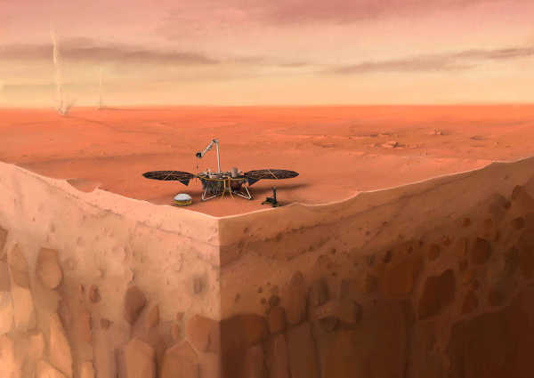
A new understanding of Mars is beginning to emerge, thanks to the first year of NASA's InSight lander mission.
Findings described in a newly published set of six papers reveal a planet alive with quakes, dust devils and strange magnetic pulses.
Five of the papers were published in Nature. An additional paper in Nature Geoscience details the InSight spacecraft's landing site, a shallow crater nicknamed "Homestead hollow" in a region called Elysium Planitia.
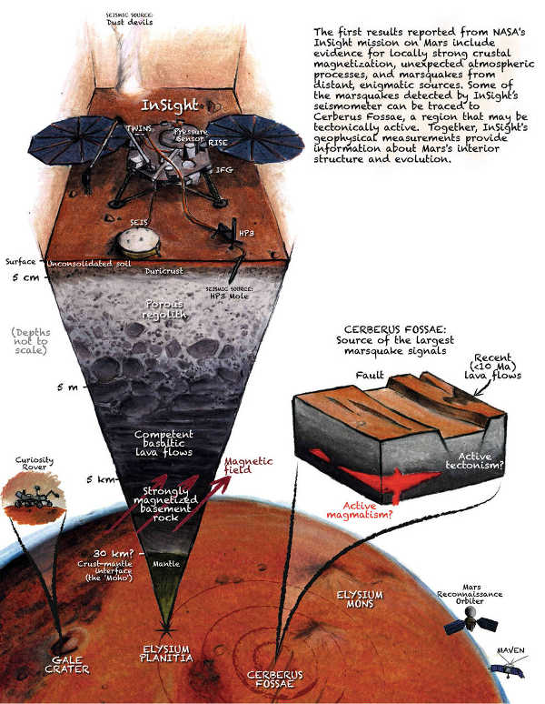
InSight is the first mission dedicated to looking deep beneath the Martian surface. Among its science tools are a seismometer for detecting quakes, sensors for gauging wind and air pressure, a magnetometer, and a heat flow probe designed to take the planet's temperature.
While the team continues to work on getting the probe into the Martian surface as intended, the ultra-sensitive seismometer, called the Seismic Experiment for Interior Structure, or SEIS, has enabled scientists to "hear" multiple trembling events from hundreds to thousands of miles away.
Seismic waves are affected by the materials they move through, giving scientists a way to study the composition of the planet's inner structure. Mars can help the team better understand how all rocky planets, including Earth, first formed.
Underground
Mars trembles more often – but also more mildly – than expected. SEIS has found more than 450 seismic signals to date, the vast majority of which are probably quakes (as opposed to data noise created by environmental factors, like wind).
The largest quake was about magnitude 4.0 in size – not quite large enough to travel down below the crust into the planet's lower mantle and core.
Those are "the juiciest parts of the apple" when it comes to studying the planet's inner structure, said Bruce Banerdt, InSight principal investigator at JPL.
Scientists are ready for more: It took months after InSight's landing in November 2018 before they recorded the first seismic event. By the end of 2019, SEIS was detecting about two seismic signals a day, suggesting that InSight just happened to touch down at a particularly quiet time. Scientists still have their fingers crossed for "the Big One."
Mars doesn't have tectonic plates like Earth, but it does have volcanically active regions that can cause rumbles.
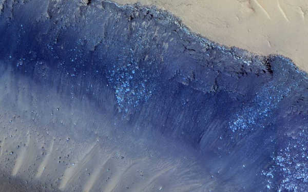
A pair of quakes was strongly linked to one such region, Cerberus Fossae, where scientists see boulders that may have been shaken down cliffsides. Ancient floods there carved channels nearly 800 miles (1,300 kilometers) long.
Lava flows then seeped into those channels within the past 10 million years – the blink of an eye in geologic time.
Some of these young lava flows show signs of having been fractured by quakes less than 2 million years ago. "It's just about the youngest tectonic feature on the planet," said planetary geologist Matt Golombek of JPL. "The fact that we're seeing evidence of shaking in this region isn't a surprise, but it's very cool."
At the surface
Billions of years ago, Mars had a magnetic field. It is no longer present, but it left ghosts behind, magnetizing ancient rocks that are now between 200 feet (61 meters) to several miles below ground. InSight is equipped with a magnetometer – the first on the surface of Mars to detect magnetic signals.
The magnetometer has found that the signals at Homestead hollow are 10 times stronger than what was predicted based on data from orbiting spacecraft that study the area. The measurements of these orbiters are averaged over a couple of hundred miles, whereas InSight's measurements are more local.
Because most surface rocks at InSight's location are too young to have been magnetized by the planet's former field, "this magnetism must be coming from ancient rocks underground," said Catherine Johnson, a planetary scientist at the University of British Columbia and the Planetary Science Institute.
"We're combining these data with what we know from seismology and geology to understand the magnetized layers below InSight,” said Johnson. “How strong or deep would they have to be for us to detect this field?"
In addition, scientists are intrigued by how these signals change over time. The measurements vary by day and night; they also tend to pulse around midnight.
Theories are still being formed as to what causes such changes, but one possibility is that they're related to the solar wind interacting with the Martian atmosphere
In the Wind
InSight measures wind speed, direction and air pressure nearly continuously, offering more data than previous landed missions.
The spacecraft's weather sensors have detected thousands of passing whirlwinds, which are called dust devils when they pick up grit and become visible.
“This site has more whirlwinds than any other place we've landed on Mars while carrying weather sensors,” said Aymeric Spiga, an atmospheric scientist at Sorbonne University in Paris.
Despite all that activity and frequent imaging, InSight's cameras have yet to see dust devils. But SEIS can feel these whirlwinds pulling on the surface like a giant vacuum cleaner.
"Whirlwinds are perfect for subsurface seismic exploration," said Philippe Lognonné of Institut de Physique du Globe de Paris, or IPGP, principal investigator of SEIS.
Still to Come: The Core
InSight has two radios: one for regularly sending and receiving data, and a more powerful radio designed to measure the "wobble" of Mars as it spins.
This X-band radio, also known as the Rotation and Interior Structure Experiment, or RISE, can eventually reveal whether the planet's core is solid or liquid. A solid core would cause Mars to wobble less than a liquid one would.
This first year of data is just a start. Watching over a full Martian year (two Earth years) will give scientists a much better idea of the size and speed of the planet's wobble.
About InSight
A division of Caltech in Pasadena, JPL manages InSight for NASA's Science Mission Directorate. InSight is part of NASA's Discovery Program, managed by the agency's Marshall Space Flight Center in Huntsville, Alabama. Lockheed Martin Space in Denver built the InSight spacecraft, including its cruise stage and lander, and supports spacecraft operations for the mission.
A number of European partners, including France's Centre National d'Études Spatiales, CNES, the German Aerospace Center, or DLR, and the United Kingdom Space Agency are supporting the InSight mission.
CNES provided the SEIS instrument to NASA, with the principal investigator at IPGP. Significant contributions for SEIS came from IPGP; the Max Planck Institute for Solar System Research in Germany; the Swiss Federal Institute of Technology in Switzerland; Imperial College London and Oxford University in the United Kingdom; and JPL.
DLR provided the Heat Flow and Physical Properties Package instrument, with significant contributions from the Space Research Center of the Polish Academy of Sciences and Astronika in Poland. Spain's Centro de Astrobiología supplied the temperature and wind sensors.
- Details
- Written by: Elizabeth Larson
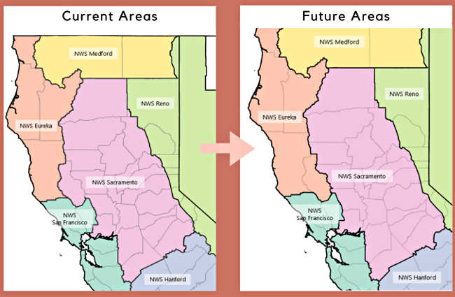
LAKE COUNTY, Calif. – The National Weather Service is preparing to transfer responsibility for Lake County’s forecast service area from its Sacramento to Eureka office.
The transition will take effect on Tuesday, March 3.
The National Weather Service said the transition will necessitate reconfiguring nearby public and fire weather zones.
The agency said both its Eureka and Sacramento offices currently provide fire weather forecasts for different portions of Lake County.
The transition will allow the Eureka office to provide forecast services to all of Caltrans District 1’s service area. In addition, it will give Lake County more focused support for weather emergencies from one National Weather Service office versus having to coordinate with two of them for forecasts and fire weather, the agency reported.
Michelle Mead, warning coordination meteorologist in the National Weather Service’s Sacramento office, said forecasts will continue to published as before at www.weather.gov, with the Eureka office not just handling the main forecasts but also taking charge of issuing flood and storm warnings.
Community members who have followed the National Weather Service’s Sacramento office on Facebook will now also want to follow Eureka, which will share weather updates there.
“We started the discussion last summer with all of the emergency management personnel in Lake County,” Mead said.
Mead said it was an idea that had been “kicked around” for some time, and then Dale Carnathan, the emergency services manager for the Lake County Office of Emergency Services, expressed interest pursuing it.
At that point, Mead said she told him about the option of moving the forecast responsibility from Sacramento to Eureka if it would serve the county better, and eventually the request was made formally.
“There wasn’t any dissatisfaction with the services that we were receiving from Sacramento,” said Teresa Stewart, assistant to the Lake County Office of Emergency Service.
Stewart explained that the agency felt that there were benefits to transferring to Eureka, including being in the same forecast area as Mendocino County, which it works with often. Lake County also shares the same emergency alert system plan with Mendocino County.
She said the emergency alert system for Lake County already is activated by the Eureka office through its weather radio transmitter in Ukiah.
Moving operations to Eureka also will streamline operations. Stewart said there is a small portion of northern Lake County’s forecast coming from Eureka in addition to the rest of the county’s forecast coming from Sacramento.
Stewart and Mead both pointed out that Mendocino and Lake counties have similar weather, and that Lake County is in the California Office of Emergency Services’ 16-county Coastal Region, which the National Weather Service’s Eureka office serves.
Mead said that, weatherwise, Lake County is more in line with the Coastal Range and the west side of the mountains.
Stewart said the county requested a change over in an Aug. 30 letter.
The Lake County Disaster Council would begin discussing the proposal in the fall, according to a meeting agenda.
Mead said National Weather Service representatives attended local meetings and presented the proposal, and everyone was in agreement with it for all of the reasons she explained.
She said it was then open for a 90-day period which concludes with the Tuesday transition.
“We continue to have a great working relationship with Lake County,” said Mead.
Ryan Aylward, Mead’s counterpart in Eureka, where he is a warning coordination meteorologist, has been working with Mead on the transition. That work has included moving over operations and interacting with weather spotters.
This week, Lake County’s weather spotters were notified of the changeover and directed to contact the Eureka office as of March 3.
“It won’t be an extremely large additional workload because we’re already doing a forecast for Mendocino County,” which has an extremely similar climate, Aylward said.
A major concern through the summer is fire weather, an area where Aylward said they are placing a lot of concentration.
When considering Lake County’s membership in the Coastal OES Region, its similar climate and the fact that it’s also a part of Caltrans District 1, headquartered in Eureka, “It makes sense to be with us,” Aylward said.
Email Elizabeth Larson at
- Details
- Written by: Elizabeth Larson
The kennels also have many dogs that need to be reunited with their owners. To find the lost/found pet section, click here.
The following dogs are ready for adoption.

‘Barkley’
“Barkley” is a male American Pit Bull Terrier mix with a short red coat.
He is dog No. 3528.

‘Blue’
“Blue” is a male pit bull terrier mix with a short white and brindle coat.
He has been neutered.
He is dog No. 3539.

‘Cha-Chi’
“Cha-Chi” is a male Chihuahua with a short gold and white coat.
He is dog No. 3661.

‘Duchess’
“Duchess” is a female Chihuahua puppy with a short tan coat.
She is dog No. 3618.

‘Garrett’
“Garrett” is a male German Shepherd mix with a medium tan and black coat.
He has been neutered.
He is dog No. 3580.

‘Nutmeg’
“Nutmeg” is a female German Shepherd mix puppy.
She has a short brown and black coat.
She is dog No. 3628.

‘Phoebe’
“Phoebe” is a female American Pit Bull Terrier mix with a short black and white coat.
She is dog No. 3483.

‘Roxy’
“Roxy” is a female German Shepherd mix with a medium-length tan and black coat.
She has been spayed.
She is dog No. 3545.

‘Tulip’
“Tulip” is a female Chihuahua puppy mix with a short tan coat.
She is dog No. 3663.

‘Woodrow’
“Woodrow” is a male Staffordshire Bull Terrier with a black and white coat.
He is dog No. 3281.
Clearlake Animal Control’s shelter is located at 6820 Old Highway 53, off Airport Road.
Hours of operation are noon to 4 p.m. Tuesday through Saturday. The shelter is closed Sundays, Mondays and major holidays; the shelter offers appointments on the days it’s closed to accommodate people.
Call the Clearlake Animal Control shelter at 707-273-9440, or email
Visit Clearlake Animal Control on Facebook or at the city’s Web site.
Email Elizabeth Larson at
- Details
- Written by: Lake County News reports
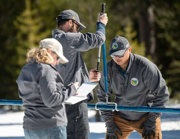
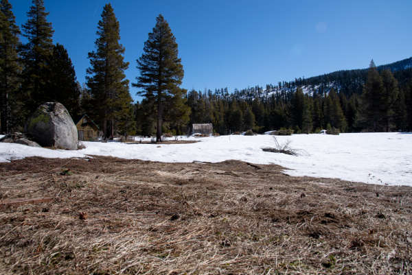
NORTHERN CALIFORNIA – The Department of Water Resources on Thursday conducted the third manual snow survey of 2020 at Phillips Station.
The manual survey recorded 29 inches of snow depth and a snow water equivalent, or SWE, of 11.5 inches, which is 47 percent of the March average for this location.
The SWE measures the amount of water contained in the snowpack, which provides a more accurate forecast of spring runoff.
“Right now, 2020 is on track to be a below-average year but we could still see large storms in March and April that will improve the current snowpack,” said Sean de Guzman, chief of DWR’s Snow Surveys and Water Supply Forecasting Section. “While periods of dry conditions are expected in California, climate change has made them more unpredictable and extreme which is why we must always use the water we have wisely.”
While February has been very dry, it’s not unprecedented for California to be in this position. In 2018, after a dry start, March storms made up much of the deficit and brought California closer to normal that year.
In addition to the manual surveys, DWR collects readings from 130 electronic snow sensors scattered throughout the state. Measurements indicate that statewide, the snowpack’s water equivalent is 11 inches, or 46 percent of the March average.
“The snowpack that we are measuring today is a critical element to all water resources managers in California, especially the State Water Project, which provides water to more than 27 million Californians and 750,000 acres of farmland,” said Molly White, chief of DWR’S State Water Project, Water Operations Office. “The data generated from snow surveys is one factor used to determine how much water will be allocated to the State Water Project Contractors.
The state’s largest six reservoirs currently hold between 92 percent (Oroville) and 132 percent (Melones) of their historical averages for this date. Lake Shasta, California’s largest surface reservoir, 107 percent of its historical average and sits at 78 percent of capacity.
DWR conducts five media-oriented snow surveys at Phillips Station each winter in January, February, March, April and, if necessary, May.
On average, the snowpack supplies about 30 percent of California’s water needs as it melts in the spring and early summer.