 How to resolve AdBlock issue?
News
- Details
- Written by: Lake County News reports
Testing beginning on Tuesday, May 5, will occur in the Lakeport area, and subsequent locations around the county will be announced as they are arranged, Public Health said.
Public Health staff will see up to 50 preregistered people per day for testing in a drive-thru setting.
Sites will be open from 11 a.m. to 1 p.m. and results should be back within 48 to 72 hours.
If more than 50 people need the test on a given day, they will try to prioritize the most vulnerable.
Call 707-263-8174 to be transferred to a staff member for screening and registration. Additional information and forms will be posted on the Public Health website.
“This is a new process, and we appreciate the community’s patience as we ‘work out the kinks,’” said Public Health Officer Dr. Gary Pace. “We look forward to testing the folks that need it.”
Pace said that getting Lake County’s own test site up and running is highly significant, given the governor’s criteria for lifting shelter-in-place restrictions.
Until counties get adequate testing and contact tracing, the governor will be reluctant to loosen things up for more social and business activity.
Therefore, this new service will be a major step forward for Lake County in meeting these benchmarks, Pace said.
Pace said the value of this viral polymerase chain reaction test lies in determining if someone has the virus right now.
The antibody test, which is in the news a lot lately, is a different test that looks for previous infection, he said.
At least for the time being, no antibody testing will be available at Lake County’s mobile sites. These logistics may all change in the near future, Pace said.
- Details
- Written by: Elizabeth Larson
In a unanimous vote, the board appointed a negotiating team that includes County Administrative Officer Carol Huchingson and two of her deputies, Susan Parker and Stephen Carter, to discuss the sale of the county-owned land at 7175 S. Center Drive in Clearlake to Lake Transit.
Last week, the California State Transportation Agency awarded Lake Transit nearly $13 million for its plans for a new transit hub and four new hydrogen buses, as Lake County News has reported.
Lake Transit’s plans include the construction of the new transit hub – which will be part of a larger regional system which connects to the Bay Area, Sacramento and Shasta County – as well as the four new zero-emission buses, new infrastructure and workforce development in coordination with local community colleges.
In January, in support of the grant application, the Board of Supervisors approved a resolution declaring its South Center Drive property as surplus and authorizing the sale of a portion of the land to Lake Transit for the new transit hub.
On Tuesday, Huchingson asked the supervisors to designate her and her staffers as the negotiating team.
Her written report said, “After completing the negotiations process, the Negotiating Team will present the tentative purchase agreement reached for consideration and approval by the Board of Supervisors in the course of a regularly scheduled and open meeting.”
Board Chair Moke Simon congratulated Lake Transit on the grant, calling its efforts “phenomenal work” for the community.
Supervisor Bruno Sabatier asked about the timeline for completing negotiations.
Huchingson said staff was ready to meet with Lake Transit and the title company is poised to handle the transaction once the terms of the sale are determined.
Sabatier moved to approve the negotiating team, which the board approved 5-0.
Lake Transit has reported that it wants to begin the project in the fall.
Email Elizabeth Larson at
- Details
- Written by: Lake County News reports
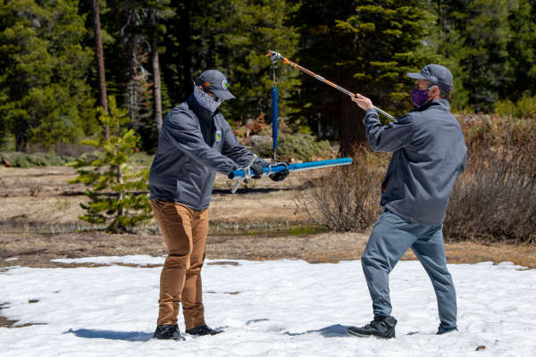
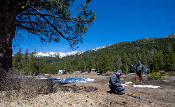
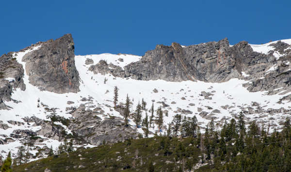
NORTHERN CALIFORNIA – California’s snowpack is heading toward the summer with an overall depth that is about a third of the average after a mostly dry winter, state officials said.
The season’s final manual snow survey at Phillips Station was conducted Thursday by the Department of Water Resources.
The survey recorded 1.5 inches of snow depth and a snow water equivalent, or SWE, of 0.5 inches, which is 3 percent of the May average for this location.
The SWE measures the amount of water contained in the snowpack, providing a more accurate forecast of spring runoff than snow depth alone.
Measurements from the 130 electronic snow sensors scattered throughout the state indicate that the statewide snowpack’s water equivalent is 8.4 inches, or 37 percent of the May average.
Thursday’s readings will help hydrologists forecast spring and summer snowmelt runoff into rivers and reservoirs.
“March and April storms brought needed snow to the Sierras, with the snowpack reaching its peak on April 9, however, those gains were not nearly enough to offset a very dry January and February,” said Sean de Guzman, chief of DWR’s Snow Survey and Water Supply Forecast Section. “The last two weeks have seen increased temperatures leading to a rapid reduction of the snowpack. Snowmelt runoff into the reservoirs is forecasted to be below average.”
California’s weather variability has been on full display this water year. Dry conditions in October and November were followed by precipitation in December that measured 120 percent of average.
Very dry conditions returned to much of the state in January and February, with March and April storms leading to the snowpack peaking at just 66 percent of average on April 9.
In normal years, the snowpack supplies about 30 percent of California’s water needs as it melts in the spring and early summer.
The greater the snow water equivalent the greater the likelihood California’s reservoirs will receive ample runoff to meet the state’s water demand in the summer and fall.
The state’s six largest reservoirs currently hold between 83 percent (San Luis) and 126 percent (Melones) of their historical averages for this date. Lake Shasta, California’s largest surface reservoir, is 94 percent of its historical average and sits at 81 percent of capacity.
- Details
- Written by: Elizabeth Larson
The National Weather Service said high clouds associated with the next weather system are approaching the area from the west, and this will very gradually increase in coverage into early Friday.
The forecast calls for generally dry conditions for the first half of Friday, but a weak weather front could bring very light showers along with increasing cloud cover inland.
From Saturday morning through late Saturday night, the National Weather Service said a “more substantial front” will move across the area. That front is expected to bring light to moderate rainfall of about a few hundredths of an inch in Lake and Mendocino counties, with more rainfall farther north.
The forecast said precipitation will begin to wind down early Sunday morning, with Monday seeing the return of drier conditions.
Temperatures this week will range into the high 70s during the day and mid-40s at night, according to the local forecast.
Winds of up to 11 miles per hour also are forecast through Sunday.
Email Elizabeth Larson at