 How to resolve AdBlock issue?
News
- Details
- Written by: Elizabeth Larson
Dogs available for adoption this week include mixes of boxer, Chihuahua, husky, pit bull, Rhodesian Ridgeback, Rottweiler and shepherd.
Dogs that are adopted from Lake County Animal Care and Control are either neutered or spayed, microchipped and, if old enough, given a rabies shot and county license before being released to their new owner. License fees do not apply to residents of the cities of Lakeport or Clearlake.
The following dogs at the Lake County Animal Care and Control shelter have been cleared for adoption (additional dogs on the animal control website not listed are still “on hold”).
Call Lake County Animal Care and Control at 707-263-0278 or visit the shelter online at http://www.co.lake.ca.us/Government/Directory/Animal_Care_And_Control.htm for information on visiting or adopting.

‘Dash’
“Dash” is a 2-year-old female Rhodesian Ridgeback mix with a short tan coat.
She is in kennel No. 15, ID No. LCAC-A-1183.

Male pit bull
This young male American pit bull has a short brown coat.
He is in kennel No. 18, ID No. LCAC-A-1028.

‘Hype’
“Hype” is a 5-year-old female boxer mix with a short red and white coat.
She is in kennel No. 20, ID No. LCAC-A-974.

‘Jim’
“Jim” is a 2-year-old pit bull terrier mix with a short black and white coat.
He is in kennel No. 23, ID No. LCAC-A-810.

“Luna” is a 3-year-old female pit bull terrier mix with a short red coat.
She is in kennel No. 25, ID No. LCAC-A-1078.

‘Tinker’
“Tinker” is a 4-year-old Chihuahua with a short tan coat.
She is in kennel No. 26a, ID No. 1074.

Rottweiler-pit bull mix
This 1-year-old female Rottweiler-pit bull mix has a short black coat.
She has been spayed.
She is in kennel No. 27, ID No. LCAC-A-731.

‘Brutus’
“Brutus” is a 5-year-old male pit bull terrier with a short gray and white coat.
He is in kennel No. 28, ID No. LCAC-A-670.

Female pit bull terrier
This 4-year-old female pit bull terrier mix has a short white coat.
She is in kennel No. 29, ID No. LCAC-A-812.

‘Apollo’
“Apollo” is a 2-year-old male husky mix with a medium-length red and white coat and blue eyes.
He is in kennel No. 31, ID No. LCAC-A-783.

Male husky
This 2-year-old male husky has a medium-length red and white coat.
He is in kennel No. 32, ID No. LCAC-A-1024.
Email Elizabeth Larson at
- Details
- Written by: Christopher Ruf, University of Michigan

Plastic is the most common type of debris floating in the world’s oceans. Waves and sunlight break much of it down into smaller particles called microplastics – fragments less than 5 millimeters across, roughly the size of a sesame seed.
To understand how microplastic pollution is affecting the ocean, scientists need to know how much is there and where it is accumulating. Most data on microplastic concentrations comes from commercial and research ships that tow plankton nets – long, cone-shaped nets with very fine mesh designed for collecting marine microorganisms.
But net trawling can sample only small areas and may be underestimating true plastic concentrations. Except in the North Atlantic and North Pacific gyres – large zones where ocean currents rotate, collecting floating debris – scientists have done very little sampling for microplastics. And there is scant information about how these particles’ concentrations vary over time.
To address these questions, University of Michigan research assistant Madeline Evans and I developed a new way to detect microplastic concentrations from space using NASA’s Cyclone Global Navigation Satellite System. CYGNSS is a network of eight microsatellites that was launched in 2016 to help scientists predict hurricanes by analyzing tropical wind speeds. They measure how wind roughens the ocean’s surface – an indicator that we realized could also be used to detect and track large quantities of microplastics.
Looking for smooth zones
Annual global production of plastic has increased every year since the 1950s, reaching 359 million metric tons in 2018. Much of it ends up in open, uncontrolled landfills, where it can wash into river drainage zones and ultimately into the world’s oceans.
Researchers first documented plastic debris in the oceans in the 1970s. Today, it accounts for an estimated 80% to 85% of marine litter.
The radars on CYGNSS satellites are designed to measure winds over the ocean indirectly by measuring how they roughen the water’s surface. We knew that when there is a lot of material floating in the water, winds don’t roughen it as much. So we tried computing how much smoother measurements indicated the surface was than it should have been if winds of the same speed were blowing across clear water.
This anomaly – the “missing roughness” – turns out to be highly correlated with the concentration of microplastics near the ocean surface. Put another way, areas where surface waters appear to be unusually smooth frequently contain high concentrations of microplastics. The smoothness could be caused by the microplastics themselves, or possibly by something else that’s associated with them.
By combining all the measurements made by CYGNSS satellites as they orbit around the world, we can create global time-lapse images of ocean microplastic concentrations. Our images readily identify the Great Pacific Garbage Patch and secondary regions of high microplastic concentration in the North Atlantic and the southern oceans.
Tracking microplastic flows over time
Since CYGNSS tracks wind speeds constantly, it lets us see how microplastic concentrations change over time. By animating a year’s worth of images, we revealed seasonal variations that were not previously known.
We found that global microplastic concentrations tend to peak in the North Atlantic and Pacific during the Northern Hemisphere’s summer months. June and July, for example, are the peak months for the Great Pacific Garbage Patch.
Concentrations in the Southern Hemisphere peak during its summer months of January and February. Lower concentrations during the winter in both hemispheres are likely due to a combination of stronger currents that break up microplastic plumes and increased vertical mixing – the exchange between surface and deeper water – that transports some of the microplastic down below the surface.
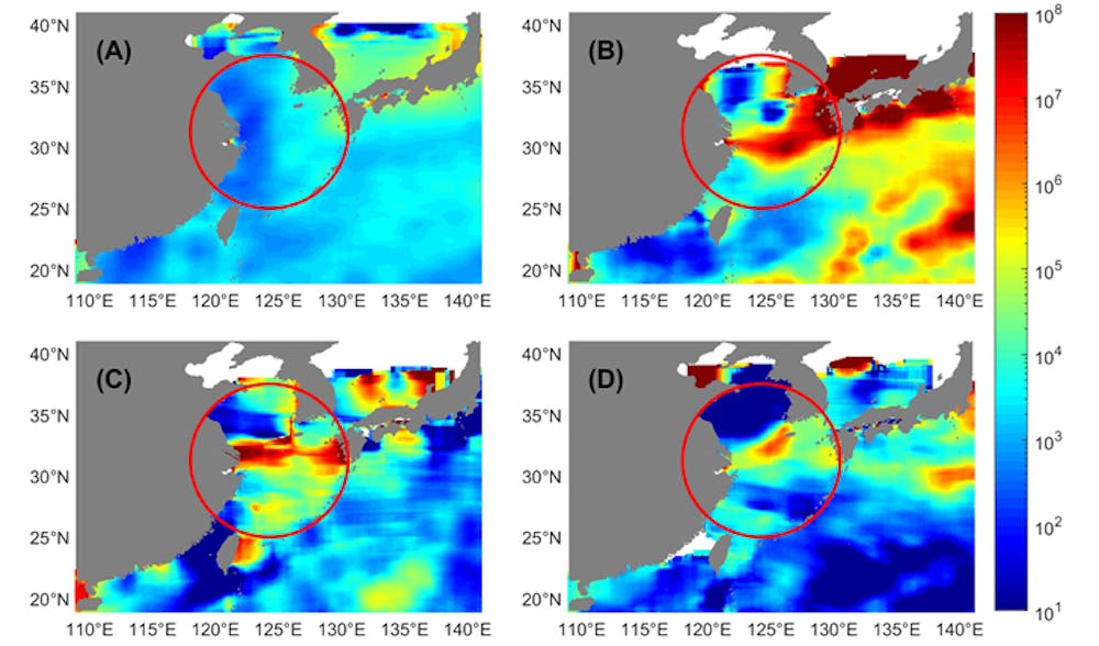
This approach can also target smaller regions over shorter periods of time. For example, we examined episodic outflow events from the mouths of the China’s Yangtze and Qiantang rivers where they empty into the East China Sea. These events may have been associated with increases in industrial production activity, or with increases in the rate at which managers allowed the rivers to flow through dams.
Better targeting for cleanups
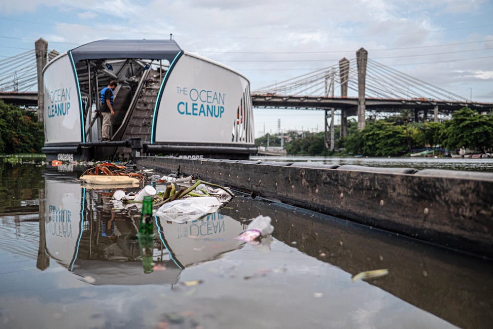
Our research has several potential uses. Private organizations, such as The Ocean Cleanup, a nonprofit in The Netherlands, and Clewat, a Finnish company specializing in clean technology, use specially outfitted ships to collect, recycle and dispose of marine litter and debris. We have begun conversations with both groups and hope eventually to help them deploy their fleets more effectively.
Our spaceborne imagery may also be used to validate and improve numerical prediction models that attempt to track how microplastics move through the oceans using ocean circulation patterns. Scholars are developing several such models.
While the ocean roughness anomalies that we observed correlate strongly with microplastic concentrations, our estimates of concentration are based on the correlations that we observed, not on a known physical relationship between floating microplastics and ocean roughness. It could be that the roughness anomalies are caused by something else that is also correlated with the presence of microplastics.
One possibility is surfactants on the ocean surface. These liquid chemical compounds, which are widely used in detergents and other products, move through the oceans in ways similar to microplastics, and they also have a damping effect on wind-driven ocean roughening.
Further study is needed to identify how the smooth areas that we identified occur, and if they are caused indirectly by surfactants, to better understand exactly how their transport mechanisms are related to those of microplastics. But I hope this research can be part of a fundamental change in tracking and managing microplastic pollution.
[The Conversation’s science, health and technology editors pick their favorite stories. Weekly on Wednesdays.]![]()
Christopher Ruf, Professor of Climate and Space Sciences and Engineering, University of Michigan
This article is republished from The Conversation under a Creative Commons license. Read the original article.
- Details
- Written by: NATIONAL AERONAUTICS AND SPACE ADMINISTRATION

Today, Mars is a planet of extremes — it's bitterly cold, has high radiation, and is bone-dry.
But billions of years ago, Mars was home to lake systems that could have sustained microbial life. As the planet's climate changed, one such lake — in Mars' Gale Crater — slowly dried out.
Scientists have new evidence that super salty water, or brines, seeped deep through the cracks, between grains of soil in the parched lake bottom and altered the clay mineral-rich layers beneath.
The findings published in the July 9 edition of the journal Science and led by the team in charge of the Chemistry and Mineralogy, or CheMin, instrument — aboard NASA's Mars Science Laboratory Curiosity rover — help add to the understanding of where the rock record preserved or destroyed evidence of Mars' past and possible signs of ancient life.
"We used to think that once these layers of clay minerals formed at the bottom of the lake in Gale Crater, they stayed that way, preserving the moment in time they formed for billions of years," said Tom Bristow, CheMin principal investigator and lead author of the paper at NASA's Ames Research Center in California's Silicon Valley. "But later brines broke down these clay minerals in some places – essentially re-setting the rock record."

Mars: It goes on your permanent record
Mars has a treasure trove of incredibly ancient rocks and minerals compared with Earth. And with Gale Crater's undisturbed layers of rocks, scientists knew it would be an excellent site to search for evidence of the planet's history, and possibly life.
Using CheMin, scientists compared samples taken from two areas about a quarter-mile apart from a layer of mudstone deposited billions of years ago at the bottom of the lake at Gale Crater.
Surprisingly, in one area, about half the clay minerals they expected to find were missing. Instead, they found mudstones rich with iron oxides — minerals that give Mars its characteristic rusty red color.
Scientists knew the mudstones sampled were about the same age and started out the same – loaded with clays — in both areas studied.
So why then, as Curiosity explored the sedimentary clay deposits along Gale Crater did patches of clay minerals — and the evidence they preserve — “disappear”?

Clays hold clues
Minerals are like a time capsule; they provide a record of what the environment was like at the time they formed. Clay minerals have water in their structure and are evidence that the soils and rocks that contain them came into contact with water at some point.
"Since the minerals we find on Mars also form in some locations on Earth, we can use what we know about how they form on Earth to tell us about how salty or acidic the waters on ancient Mars were," said Liz Rampe, CheMin deputy principal investigator and co-author at NASA’s Johnson Space Center in Houston.
Previous work revealed that, while Gale Crater's lakes were present and even after they dried out, groundwater moved below the surface, dissolving and transporting chemicals.
After they were deposited and buried, some mudstone pockets experienced different conditions and processes due to interactions with these waters that changed the mineralogy.
This process, known as "diagenesis," often complicates or erases the soil's previous history and writes a new one.
Diagenesis creates an underground environment that can support microbial life. In fact, some very unique habitats on Earth — in which microbes thrive — are known as "deep biospheres."
"These are excellent places to look for evidence of ancient life and gauge habitability," said John Grotzinger, CheMin co-investigator and co-author at Caltech in Pasadena, California. "Even though diagenesis may erase the signs of life in the original lake, it creates the chemical gradients necessary to support subsurface life, so we are really excited to have discovered this."
By comparing the details of minerals from both samples, the team concluded that briny water filtering down through overlying sediment layers was responsible for the changes. Unlike the relatively freshwater lake present when the mudstones formed, the salty water is suspected to have come from later lakes that existed within an overall drier environment.
Scientists believe these results offer further evidence of the impacts of Mars's climate change billions of years ago. They also provide more detailed information that is then used to guide the Curiosity rover’s investigations into the history of the Red Planet.
This information also will be utilized by NASA’s Mars 2020 Perseverance rover team as they evaluate and select rock samples for eventual return to Earth.
"We've learned something very important: there are some parts of the Martian rock record that aren't so good at preserving evidence of the planet's past and possible life," said Ashwin Vasavada, Curiosity project scientist and co-author at NASA's Jet Propulsion Laboratory in Southern California. "The fortunate thing is we find both close together in Gale Crater, and can use mineralogy to tell which is which."
Curiosity is in the initial phase of investigating the transition to a "sulfate-bearing unit," or rocks thought to have formed while Mars's climate dried out.
The mission is managed by JPL, a division of Caltech, for NASA's Science Mission Directorate, Washington. Colleagues in NASA’s Astromaterials Research and Exploration Science Division at Johnson and NASA's Goddard Space Flight Center in Greenbelt, Maryland also are authors on the paper, as well as other institutions working on Curiosity.

- Details
- Written by: Lake County News reports
The goal of the Flex Alert is to avoid a possible shortage of energy as extreme heat in California and a growing wildfire in Southern Oregon threatening transmission lines continue to strain the state’s electric grid.
When the Flex Alert is in effect again between 4 p.m. and 9 p.m. on Saturday, July 10, California’s residents are strongly encouraged to conserve energy by:
— Setting thermostats to 78 degrees or higher, if health permits.
— Avoiding using major appliances.
— Turning off all unnecessary lights.
Consumers are also encouraged to use fans for cooling and unplug unused electrical items.
Earlier in the day, before the Flex Alert takes effect and when solar energy is abundant, consumers are encouraged to take these steps to be comfortable and help grid operators balance electricity supply and demand:
— Pre-cool your home by lowering the thermostat.
— If you need to use your major appliances, do it before the Flex Alert is in effect, when solar energy is plentiful.
— Close window coverings to keep your home or apartment cool.
— Charge electronic devices and electric vehicles so there’s no need to do it later, when solar generation is down.
In addition to the Flex Alert, the California Independent System Operator is using multiple tools to help keep the grid stable, including a solicitation on July 1 to generators in the Western region to procure additional resources.
The California Independent System Operator is also working with business and industry to help them reduce electricity consumption at critical times.
Conditions on the grid became more challenging Friday afternoon when the rapidly expanding Bootleg wildfire in southern Oregon was threatening electric transmission lines, putting limits on the amount of energy that can be imported to California.
Voluntary conservation has helped keep the electric grid stable during past times of high stress on the grid, including last month when triple-digit temperatures across the West strained the system with higher demand for power.
Grid operators continue to closely monitor conditions and will have additional announcements as needed.
As California’s ability to store solar and wind energy with batteries or other technology continues to advance, crucial evening hours will be less of a challenge and similar emergencies rarer. But for now, collective action to conserve is our most effective way to support grid reliability.
For information on Flex Alerts, and to get more electricity conservation tips, visit the California Independent System Operator’s Flex Alert website.