 How to resolve AdBlock issue?
News
- Details
- Written by: Jude Coleman
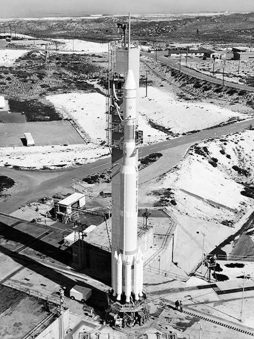
Virginia T. Norwood, known as the person who could solve impossible problems, played a crucial role in the development of the first space-based multispectral scanner instrument that flew on Landsat 1 and made the mission a success. Working together with NASA, USGS, university researchers, and her team at Hughes, Norwood successfully yoked the pioneering technology that made regular digital imagery of Earth from space possible. Credits: NASA's Goddard Space Flight Center.
On a warm July day in 1972, NASA launched a new Earth-imaging satellite called the Earth Resources Technology Satellite.
“ERTS” was the first satellite of what later became NASA and the U.S. Geological Survey’s Landsat Program, an ambitious effort with a vision of documenting the entirety of Earth from space.
The first Landsat was so successful it led to a series of satellites that have created the longest contiguous record of Earth’s surface from a space-eye view – that continues growing to this day, 50 years later.
“The early Landsats revolutionized the way we observed the Earth from space,” said Jim Irons, director emeritus of the Earth Sciences Division at NASA’s Goddard Space Flight Center in Greenbelt, Maryland.
Since its debut, Landsat has amassed over 10 million images. These images, also called scenes, show current snapshots of land and coasts, but pair with images of years past and they also reveal changes through time — glaciers slowly disappearing, or urban spaces sprawling across the landscape.
These scenes and time series have myriad applications around the globe: Hydrologists use them to track how rivers change; ecologists use them to determine the extent of deforestation; farmers and agricultural organizations use them to analyze crop health.
During Landsat’s five decades, eight different Landsat satellites have circled the planet. Currently, three continue to collect global observations from space: Landsats 7, 8, and 9. (Landsat 6 was lost shortly after launch.) Landsat 9, the newest of the bunch, entered orbit in fall of 2021. While Landsat 9 shares similarities with its predecessors, the Landsat satellite design has evolved immensely since the program’s emergence.

Early days
The first two Landsats could see in four spectral bands, or wavelengths of light: visible light in red and green, and two near-infrared bands. The near-infrared allowed the satellites to distinguish vegetation from other land cover and assess plant health, while the visible wavelengths differentiated bright surfaces, like snow, deserts and clouds, from dark surfaces like water. Each scene encompassed a roughly square area of around 115 miles to a side.
The first Landsats’ data transmitted to Earth were recorded on magnetic tapes, the same basic tech as music cassettes – but much bigger: The bulky wideband video tape recorders that flew on the first three Landsats each had 1,800 feet of tape and weighed in at 76 pounds apiece.
From this data, scientists generated and printed out photographic images. These photos gave a general space-eye view of an area, but the real power of the data came after computer algorithms helped scientists and resource managers to more efficiently identify the categories of land cover they represented.
Printers spat out paper maps with letter, number, and symbol combinations, where each character represented a land cover category, such as cropland or forest.
“You’d get out colored pencils or magic markers and you’d color the different characters, each with its own color,” Irons said. “That would give you an early version of a color-coded land cover map.”
Goddard was NASA’s home for Landsat going back to the program’s inception. Irons served as the deputy project scientist on Landsat 7 and project scientist on Landsat 8, helping to further shape the program and playing a pivotal role in the satellites’ development. In his 43 years working with Landsat, he’s watched the satellites grow into what they are today.
Landsat data in the ’80s and ’90s were critical to many projects, such as understanding the extent of tree loss in rainforests, Irons said. Likewise, Chris Neigh, Landsat 9’s project scientist at Goddard, uses time series to watch the slow northward creep of boreal forests, as the trees progressively inch toward the pole in response to global warming.
The long pedigree of Landsat data is essential for this kind of research, Neigh added: there are few other records to reference, and none as comprehensive.
2000s: Free access to the Landsat archive
After a failed launch of Landsat 6, Landsat 7 embarked successfully in 1999, equipped with improved instruments and roughly double the resolution of its predecessors. NASA deliberated for seven years between the launches of Landsat 7 and Landsat 8, trying to decide how to move forward with the program before beginning another seven-year process of building and launching the next satellite.
In that time, image management returned from commercial providers to USGS, which made the entire Landsat archives freely available in 2008. Image requests skyrocketed. Landsat all-time downloads topped 100 million scenes in 2020, and the number continues to rise.
As Landsat continues to transform, the people and projects that use it grow too: The United States Department of Agriculture relies on Landsat to guide farmers in watering practices and land management; climate scientists watch glaciers retreat as temperatures rise; in the drought-stricken West, water managers monitor reservoir levels.
Landsat’s next adventure
With a data user community that keeps growing, scientists and engineers are already looking forward to the next mission. NASA and USGS are developing options for the next iteration of Landsat, currently called Landsat Next.
Landsat’s eyes in space have granted new opportunities for understanding our changing planet, but the simple awe of seeing Earth is sometimes forgotten, Irons said.
“We can’t all be astronauts,” Irons said. “But if we look at Landsat images, we can understand what the Earth would look like if we were orbiting the Earth in space.”
Jude Coleman works for NASA’s Goddard Space Flight Center in Greenbelt, Maryland.

- Details
- Written by: Elizabeth Larson
The current director, Mary Darby, gave the board her resignation after a closed session evaluation on Tuesday, July 12. It’s effective Nov. 4.
Human Resources Director Pam Samac laid out the plan for the recruitment to find the seventh director for Community Development since 2016.
She said they opened the recruitment on July 14. If they don’t get a decent pool of qualified candidates, they want to put it out to 10 recruiters to find one to lead the process.
After reviewing the candidates, if it’s warranted, Samac wants to schedule interviews with the board.
Supervisor Bruno Sabatier said he wanted the county to use professional recruitment firms to find department director jobs.
Samac said it’s possible the county could get a number of good candidates as they did recently for the assistant county administrative officer without using a recruiter. She added that during the last six months ago the county has started getting better candidates for senior positions.
She advocated for the county starting the recruitment on its own and waiting three weeks before paying $25,000 to $30,000 for a recruiter.
At the same time, she said they could put out a bid request to recruiters so that it can be underway while the county is taking initial applications.
The county is now conducting another recruitment for a Public Health officer. Samac said the recruitment agencies her recruiter network uses are very busy, and have been saying they are too busy to even give quotes for services. However, that could have changed and she said they could ask for bids again.
Samac said she would have the first review of applications on Aug. 9. At that point, she said they already had one qualified applicant.
She said that they could make an assessment on Aug. 9 about what applicants they have. “I don’t believe that you have to have four or five to compare and contrast if you have one great candidate.”
At the suggestion of County Administrative Officer Susan Parker, the board agreed to have a standing item on its closed session agenda to discuss the recruitment.
Darby suggested to the board that they also advertise the job with the American Planning Association, as she said that’s where all the certified planners are and the county can get some great candidates there.
Email Elizabeth Larson at
- Details
- Written by: GOVERNOR’S OFFICE
The governor’s accelerated climate plan reinforces California’s leadership in addressing climate change, and will move the state faster toward carbon neutrality.
In a letter to the chair of the California Air Resources Board, or CARB, Gov. Newsom called for the state to ensure that the 2022 Climate Change Scoping Plan provides a path to achieve both the 2030 climate goal and state carbon neutrality no later than 2045, requesting that the final plan incorporate new efforts to advance offshore wind, clean fuels, climate-friendly homes, carbon removal and addressing methane leaks.
Last month, Gov. Newsom signed a state budget that will make it easier to bring clean energy projects online, speeding up the environmental review process of new clean energy projects, and helping the state move away from electricity generated from fossil fuels.
The governor also announced that he will work with the Legislature to enshrine carbon neutrality into state law, increase the state’s ambition towards our 2030 climate goals and accelerate our clean energy targets, while supporting carbon sequestration from our natural and working lands and advancing safe and equitable engineered carbon removal.
He will also work to finalize the state’s historic investments under the $53.9 billion climate commitment, with a focus on equity and community resilience, while expanding opportunities for climate innovation and manufacturing here in California.
“California communities experience the devastating impacts of climate change every day. We need to supercharge our efforts to significantly reduce harmful carbon pollution. The state’s draft carbon neutrality road map doesn’t go far enough or fast enough. That’s why I’m pushing state agencies to adopt more aggressive actions, from offshore wind to climate-friendly homes, and to make sure we never build another fossil fuel power plant in California again,” said Governor Newsom.
The new targets and requested actions outlined in the letter include:
• Offshore wind: Establishing a California Energy Commission planning goal of at least 20GW of offshore wind in 2045.
• Clean and healthy buildings: Creating a goal of 3 million climate-ready and climate-friendly homes by 2030 and 7 million by 2035, supplemented by 6 million heat pumps by 2030, and directing 50 percent of investments to low-income and disadvantaged communities.
• Moving away from fossil fuels: Directing state agencies to plan for an energy transition to meet our long-term energy goals that avoids the need for new natural gas plants, while ensuring reliability. Establishing a 20 percent clean fuels target for the aviation sector. The Governor also requested that CARB evaluate a more stringent Low Carbon Fuel Standard and accelerate refinery transitions to clean fuels production.
• Methane: Forming a Task Force to identify and address methane leaks from oil infrastructure near communities, recognizing the threats these leaks can pose to community health and safety.
• Carbon removal: Setting a 20 MMT carbon removal target for 2030 and 100 MMT carbon removal target for 2045, emphasizing the role of natural and working lands and the need for safe and equitable engineered carbon removal.
• Increasing climate ambition: Partnering with the Legislature to make carbon neutrality state law and accelerate progress toward California’s 2030 target; bring new ambition to the state’s clean energy goals; develop policy to support sequestration from natural and working lands while incorporating industrial carbon capture in carbon neutrality efforts; and finalize investments under the state’s $53.9 billion Climate Commitment.
The California Air Resources Board will meet in the fall to consider adopting a final draft of the 2022 Climate Change Scoping Plan.
Gov. Newsom on Friday also announced the launch of a new climate dashboard highlighting state climate action and progress toward key targets.
CalEPA will continue to expand the dashboard to help Californians understand the actions the state is taking to adapt to a changing climate, and track progress in areas such as zero-emission vehicle sales, clean energy job creation and consumer savings from energy efficiency standards.
- Details
- Written by: Alisha Butler, Wesleyan University
Food deserts. Poor housing conditions. Lack of community investment.
These challenges may not always come to mind when people think about how to improve America’s public schools.
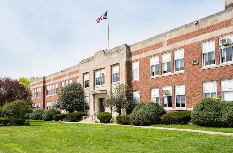
But when my colleagues and I studied the 21st Century School Buildings Program, a US$1.1 billion school building and renovation initiative in Baltimore, these were the kinds of issues that staff from community-based organizations, schools, philanthropic organizations and city agencies hoped to address through improved school facilities.
Schools are the “hubs and hearts” of neighborhoods, as one community member told us during our research in the Southeast, Southwest and Cherry Hill sections of Baltimore. If, as one community school coordinator shared, schools want to achieve their goals to educate students, they should strengthen the communities that surround them.
Our research suggests four ways schools might play a more meaningful role in supporting community development:
1. Open schools to the wider community
Making schools accessible to residents can strengthen the connection between schools and neighborhoods.
In Southeast, one school included space to host programs for newcomers to the United States. Those programs provided English language classes for students, as well as academic and social supports to help students and their families understand U.S. schools’ culture.
As a community school coordinator in Cherry Hill told us: “We can promote events and workshops and services to the entire community because they’re all happening here.”
However, although schools in our study were open in theory, they were not always easily accessible. Organizations sometimes encountered barriers, such as needing permits or having to pay fees to cover custodians or security, to host public events at schools. Our research suggests that collaboration between school districts and other city agencies can help make shared spaces more accessible by using a broader definition of community beyond just the school community, such as parents and teachers. They can also eliminate required permits and fees.
2. Meet community needs
Schools in our study partnered with community-based organizations and governmental agencies to provide services to meet their community’s needs.
In Southwest, a school partnered with local organizations to offer families a food pantry and adult education, including GED preparation.
In Cherry Hill, where access to full-service grocery stores is limited, a community school coordinator reached out to a local organization to host a morning produce market at the school once per week. A representative from the city housing authority also visited the school to make it easier for families to file complaints about poor housing conditions, such as mold.
3. Engage the community
Across all three communities, officials sought input from students, families and residents about the renovation plans or designs for new schools. They also provided updates about the construction process.
Other projects included creating a walking school bus – where adult volunteers walked with children to school – in Southwest to help students travel to and from school safely.
In Southeast, parents’ advocacy to improve school facilities – such as heating and cooling systems – helped them become more involved in their neighborhoods. Families from the schools have participated in neighborhood beautification projects, community cleanups and other activities.
Strong family and community engagement, however, is not a given. Successful partnerships also require trust among schools, families and community members. In Southwest, one school’s construction resulted in another school’s closure. The students from the old school would be sent to the new school. Families from the closed school saw their school as a safe haven and fought to prevent its closure. According to one community advocate, the process of closing the school led some families to lose faith in community organizations, the school district and city agencies.
4. Attract new residents and development
Many stakeholders that we talked to saw the new and renovated schools as a way to bring new residents, businesses and development to their communities.
In Southwest, one stakeholder told us that the new school building has led to greater interest among residents to invest in the neighborhood. “There’s a lot of residents who are organized and involved in these neighborhoods. They’re saying, ‘Hey, we got a new school. Let’s build up this neighborhood.’” Similarly, families in Southeast have become more excited about the renovated schools. A nonprofit representative said, “We see it on Facebook feeds. Because we put the [school] designs out there as much as we can, they’re starting to think, ‘Maybe I’ll put my child there.’”
However, as schools attract more residents, people in Cherry Hill and Southeast wanted to be sure existing residents weren’t pushed out. In both neighborhoods, school and community partners are creating pathways to help existing residents to purchase homes in their neighborhoods. This includes home ownership counseling and loan programs for qualifying residents.
Education will always be the primary function of America’s public schools. But as our research suggests, schools need not only concern themselves with what takes place in the classroom – they can also play an important part in improving the conditions in the surrounding community.![]()
Alisha Butler, Provost's Equity Fellow, Wesleyan University
This article is republished from The Conversation under a Creative Commons license. Read the original article.