 How to resolve AdBlock issue?
News
- Details
- Written by: NATIONAL AERONAUTICS AND SPACE ADMINISTRATION
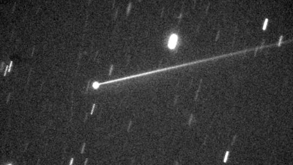
Since NASA’s Double Asteroid Redirection Test, or DART, spacecraft intentionally slammed into the asteroid moonlet Dimorphos on Sept. 26 — altering its orbit by 33 minutes — the investigation team has been digging into the implications of how this planetary defense technique could be used in the future, if such a need should ever arise.
This has included further analysis of the “ejecta” — the many tons of asteroidal rock displaced and launched into space by the impact — the recoil from which substantially enhanced DART’s push against Dimorphos.
Continued observations of that evolving ejecta have given the investigation team better understanding of what the DART spacecraft achieved at the impact site. DART team members provided a preliminary interpretation of their findings during the American Geophysical Union’s Fall Meeting on Thursday, Dec. 15, in Chicago.
“What we can learn from the DART mission is all part of a NASA’s overarching work to understand asteroids and other small bodies in our Solar System,” said Tom Statler, the program scientist for DART at NASA headquarters in Washington, and one of the presenters at the briefing. “Impacting the asteroid was just the start. Now we use the observations to study what these bodies are made of and how they were formed — as well as how to defend our planet should there ever be an asteroid headed our way.”
Central to this effort are detailed, post-impact science and engineering analyses of data from the world’s first planetary defense technology demonstration. In the weeks after impact, scientists turned their focus toward measuring the momentum transfer from DART’s roughly 14,000 mile per hour (22,530 kilometer per hour) collision with its target asteroid.
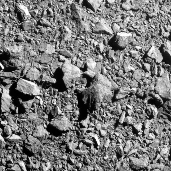
Scientists estimate DART’s impact displaced over two million pounds (one million kilograms) of the dusty rock into space — enough to fill six or seven rail cars. The team is using that data — as well as new information on the composition of the asteroid moonlet and the characteristics of the ejecta, gained from telescope observations and images from DART’s ride-along Light Italian CubeSat for Imaging of Asteroids (LICIACube) contributed by the Italian Space Agency (ASI) — to learn just how much DART’s initial hit moved the asteroid, and how much came from the recoil.
“We know the initial experiment worked. Now we can start to apply this knowledge,” said Andy Rivkin, DART investigation team colead at the Johns Hopkins Applied Physics Lab (APL). “Studying the ejecta made in the kinetic impact — all of it derived from Dimorphos — is a key way of gaining further insights into the nature of its surface.”
Observations before and after impact, reveal that Dimorphos and its larger parent asteroid, Didymos, have similar makeup and are composed of the same material — material that has been linked to ordinary chondrites, similar to the most common type of meteorite to impact the Earth. These measurements also took advantage of the ejecta from Dimorphos, which dominated the reflected light from the system in the days after impact. Even now, telescope images of the Didymos system show how solar radiation pressure has stretched the ejecta stream into a comet-like tail tens of thousands of miles in length.
Putting those pieces together, and assuming that Didymos and Dimorphos have the same densities, the team calculates that the momentum transferred when DART hit Dimorphos was roughly 3.6 times greater than if the asteroid had simply absorbed the spacecraft and produced no ejecta at all — indicating the ejecta contributed to moving the asteroid more than the spacecraft did.
Accurately predicting momentum transfer is central to planning a future kinetic impact mission if one is ever needed, including determining the size of the impactor spacecraft and estimating the amount of lead-time necessary to ensure that a small deflection would move a potentially dangerous asteroid off its path.
“Momentum transfer is one of the most important things we can measure, because it is information we would need to develop an impactor mission to divert a threatening asteroid,” said Andy Cheng, DART investigation team lead from Johns Hopkins APL. “Understanding how a spacecraft impact will change an asteroid’s momentum is key to designing a mitigation strategy for a planetary defense scenario.”
Neither Dimorphos nor Didymos poses any hazard to Earth before or after DART’s controlled collision with Dimorphos.
Johns Hopkins APL built and operated the DART spacecraft and manages the DART mission for NASA's Planetary Defense Coordination Office as a project of the agency's Planetary Missions Program Office.
For more information about the DART mission, visit https://www.nasa.gov/dart.
- Details
- Written by: Cal Fire
Cal Fire’s Office of the State Fire Marshal is beginning a public comment period for the regulatory adoption process to update the existing map that captures Fire Hazard Severity Zones, or FHSZ, which is a comprehensive map that ranks California’s State Responsibility Area — or rural, unincorporated areas — based on the likelihood different areas will experience wildfire.
After years of work to develop a sound scientific basis and methodology with a range of experts and stakeholders, updates to this map bring this valuable tool and statutory requirement current in a way that accurately reflects today’s reality for wildfire hazard throughout the state.
More specifically, this process includes a few details to know below:
• This current revision only updates areas in California’s unincorporated, rural areas where wildfires tend to be frequent — called the “SRA” or “State Responsibility Area.” This does not include cities or large urban areas.
• This process does not change rules or requirements for homes or properties in these areas related to wildfire prevention, preparedness, and mitigation. The same requirements will remain regardless of whether a particular area is reclassified or not.
• The last Wildfire Hazard Severity Zone map was updated in 2007 and required an update. A lot has happened since 2007. Using the best available science with academic researchers and others, this updated map reflects the impacts of a changing climate and includes a variety of other key factors.
• This is the beginning of a nearly two-month public process. These maps are being shared for your comments and questions during the regulatory process. A total of 57 public hearings will be held throughout the state with the goal of hearing from you.
• An online public toolkit and interactive map is available to help answer your questions. Take some time to explore your address, read the FAQs, learn about the process and where to turn. A hotline is also available to help answer your questions directly and to help increase
access.
“Ensuring Californians know the wildfire hazard in their area is critical to ensuring we all take the appropriate steps to prepare for wildfires,” said Chief Daniel Berlant, CAL FIRE Deputy Director of Community Wildfire Preparedness and Mitigation. “The updated map is the product of years of discussions and incorporates the latest science to provide a long-term outlook of an area’s wildfire hazard.”
Cal Fire’s fire scientists and wildfire mitigation experts developed the map using a science-based and field-tested model that assigns a hazard score based on the factors that influence fire likelihood and fire behavior.
Many factors are considered, such as fire history, existing and potential fuel (natural vegetation), predicted flame length, blowing embers, terrain, and typical fire weather for an area. These zones fall into the following classifications – moderate, high, and very high.
Working closely with the Department of Insurance and other agencies, Cal Fire is creating a shared approach to further reduce wildfire risk that assists residents and businesses with accessing affordable insurance.
The department’s first-ever report on climate insurance recommended updated wildfire hazard mapping to improve public safety. Insurance companies and researchers, along with insurance agents and brokers, have been involved throughout this process to ensure cooperation between all sectors to better support Californians.
And while insurance companies use similar methodologies to calculate risk as they price their insurance offerings to consumers, insurance risk models also incorporate many factors beyond this process, and many of these factors can change more frequently than those that Cal Fire includes in its hazard mapping.
Cal Fire remains committed to answering all questions from the public and working with the Department of Insurance, the insurance industry, and consumer groups throughout this process.
“Making California safer from wildfires is our top priority, and my Department of Insurance will continue to work closely with the first responders at Cal Fire to better prepare our communities,” said Insurance Commissioner Ricardo Lara.
Earlier this year, Lara issued the Safer from Wildfires insurance framework with Cal Fire and other agencies and finalized his new regulation to increase access to wildfire safety discounts and to ensure consumers can learn more about wildfire risks being considered by their insurance company.
“Public education about where current wildfire hazards exist is essential to reducing the threat to local communities and maintaining access to affordable insurance. I encourage Californians to ask questions in this public process and to learn more about the tools that exist to help communities and governments reduce their local risks.”
Overall, the map shows increased fire hazard, reflecting California’s increase in wildfire occurrence and severity because of many factors, including a changing climate. The map has been updated to more accurately reflect the zones in California that are susceptible to wildfire, to help provide transparency for planning and preparedness efforts, and to provide communities a forecasting tool so that the public can take steps to prevent and prepare for wildfire.
The hazard mapping process incorporates local climate data and changes in burn probability based on recent trends in fire occurrence.
The model was reviewed and validated by members of the science community, as well as with outreach with various stakeholders including insurance, building, fire and local agencies.
“Counties acknowledge the importance of accurately mapping fire hazard severity zones,” said Doug Teeter, Butte County supervisor and incoming chair, Rural County Representatives of California. “RCRC member counties appreciate Cal Fire’s continued engagement of local governments in this important effort.”
The State Fire Marshal is mandated by California Public Resource Code 4202-4204 to classify lands within the SRA into FHSZs and the most recent SRA FHSZ map was last updated in 2007.
The FHSZ zones are used for several purposes, including to designate areas where California’s defensible space standards, wildland-urban interface building codes, and the State Minimum Fire Safe Regulations are required.
They can be a factor in real estate disclosure, and local governments may consider them in their general plan. However, officials stress it is important to note that within the SRA mitigation requirements already apply to all zones. A designation change for an area does not affect the legal requirements for mitigations since they are already required consistently across the SRA.
“As we continue to focus on addressing California’s housing crisis, we support the importance of building so that structures are safely designed and built to mitigate an area’s wildfire hazard,” said Dan Dunmoyer, president and CEO of the California Building Industry Association. “To build more fire safe communities in the future, it is critically important for Cal Fire to update these maps to ensure we all can take steps to build a more resilient California.”
Ways to stay informed and join the conversation
As part of the adoption process of the map, Cal Fire invites public comment on the proposed map between Dec. 16, 2022, and Feb. 3, 2023.
The public may submit written comment at the address below or through email at
In addition, Cal Fire will host a public comment hearing in all 56 counties that have SRA to receive public comment. Information on the hearings can be found on Cal Fire’s website.
Written comments may be submitted by U.S. mail to the following address: Office of the State Fire Marshal, C/O: FHSZ Comments, California Department of Forestry and Fire Protection P.O. Box 944246, Sacramento, CA 94244-2460.
To determine the FHSZ of a property, the public can easily search an address using a new FHSZ Viewer at osfm.fire.ca.gov/FHSZ.
In order to help California residents better understand the FHSZ map and answer questions, Cal Fire has created a public toolkit on its website to include new and easy to follow sections, including maps, frequently asked questions, and an automated “hotline” to contact for specific information.
The new website also includes dates, times, and locations of FHSZ public hearings that will be held in the 56 counties that have FHSZs within the SRA. For information about FHSZs, visit the program’s website at osfm.fire.ca.gov/FHSZ. The public can also call an automated hotline at (916) 633-7655.
Following the adoption of the SRA FHSZ Map, Cal Fire’s Office of the State Fire Marshal will begin providing local governments updated FHSZ maps for Local Responsibility Areas.
Under California Government Code 51178, the State Fire Marshal is required to provide local agencies with the areas within their jurisdiction that meet FHSZ criteria for their local adoption and implementation.
- Details
- Written by: LAKE COUNTY NEWS REPORTS

The California Highway Patrol’s first female and second Black commissioner is planning to retire.
Amanda L. Ray, commissioner of the California Highway Patrol, since her appointment in 2020, announced her retirement effective Dec. 30.
“I am humbled and proud to have served as the Commissioner of the California Highway Patrol for the last two years.” said Commissioner Ray. “I am confident the department will continue to thrive through the commitment and compassion of the incredible women and men of this great organization.”
On Nov. 17, 2020, Gov. Gavin Newsom appointed Amanda L. Ray as the 16th commissioner of the CHP; the first woman to lead the department of more than 11,000 members and the second Black commissioner.
“Commissioner Ray has been a steadfast partner in our work to protect public safety, build a CHP that is more representative of California’s communities and create a criminal justice system that better serves all Californians,” said Gov. Gavin Newsom in response to Ray’s announcement. “Working her way up the ranks to become the first woman to lead the CHP, Commissioner Ray is an inspiration to the next generation of women and men stepping up to serve our communities with compassion and understanding. I thank her for her committed leadership and service over more than 30 years at CHP and wish her all the best for the future.”
Prior to her appointment, Commissioner Ray served as the deputy commissioner and was responsible for the day-to-day operations of the CHP.
Commissioner Ray has held every rank within the CHP.
Commissioner Ray began her career in 1990 in South Los Angeles before being promoted to sergeant and lieutenant in Santa Fe Springs.
She has served as commander in the Riverside and Hayward Areas, and an assistant chief in Golden Gate Division and Inland Division, before promoting into the CHP Executive Management team.
Commissioner Ray played an integral role as the department’s first female to be assigned as the Special Response Team Tactical Commander during Super Bowl 50 held at Levi Stadium in Santa Clara.
Her vast field experience has allowed her to effectively serve as incident commander during a variety of other high-profile events including the Department’s response to COVID-19, civil unrest and wildfires.
Effective Dec. 31, Deputy Commissioner Sean Duryee will serve as the acting CHP commissioner.
“It is a great honor to have the opportunity to serve as the Acting Commissioner,” Deputy Commissioner Duryee said.
- Details
- Written by: Elizabeth Larson
The City of Clearlake Animal Association also is seeking fosters for the animals waiting to be adopted.
Call the Clearlake Animal Control shelter at 707-273-9440, or email
Visit Clearlake Animal Control on Facebook or on the city’s website.
The following dogs are available for adoption.
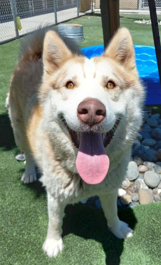
‘Aoki’
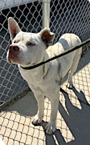
“Aoki” is a male Siberian husky mix with a white coat.
He has been neutered.
He is dog No. 50905477.

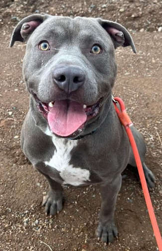
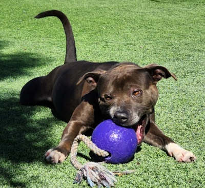
‘Athena’
“Athena” is a female American pit bull mix terrier with a short brindle coat.
She has been spayed.
She is dog No. 49934476.
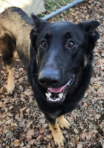
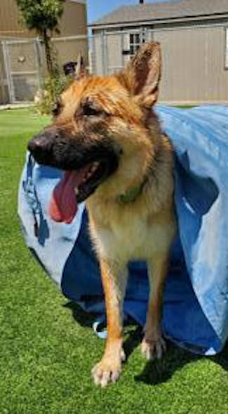
‘Atlas’
“Atlas” is a male German shepherd with a black and tan coat.
He has been neutered.
He is dog No. 51331471.

‘Babs’
“Babs” is a female Labrador retriever mix with a short black coat.
She has been spayed.
She is dog No. 49505856.
‘Bruce’
“Bruce” is a 2-year-old American pit bull mix with a short gray coat with white markings.
He has been neutered.
He is dog No. 50684304.

‘Buster’
“Buster” is a male pit bull mix with a short tan coat.
He has been neutered.
He is dog No. 50762164.
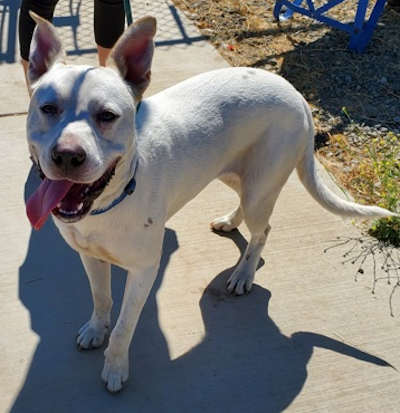
‘Domino’
“Domino” is a male terrier mix with a short white coat.
He has been neutered.
He is dog No. 50815541.

‘Eros’
“Eros” is a male Rottweiler mix with a short black and tan coat.
He has been neutered.
He is dog No. 50754504.

‘Foxie’
“Foxie” is a female German shepherd with a red, black and white coat.
She has been spayed.
She is dog No. 49702845.

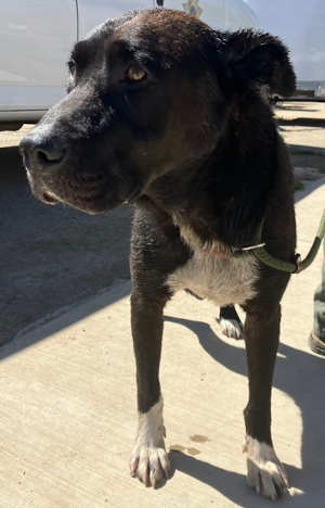
‘Goliath’
“Goliath” is a male Rottweiler mix with a short black and tan coat.
He is dog No. 50754509.

‘Hakuna’
“Hakuna” is a male shepherd mix with a tan coat.
He has been neutered.
He is dog No. 50176912.

‘Herman’
“Herman” is a 7-year-old male American pit bull terrier mix with a brown coat.
He has been neutered.
He is dog No. 51236411.
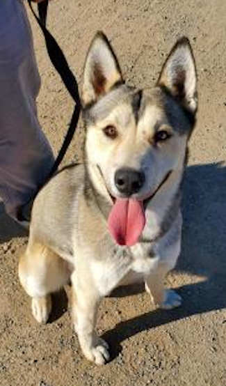
‘Hondo’
“Hondo” is a male Alaskan husky mix with a buff coat.
He has been neutered.
He’s dog No. 50227693.

‘Jack’
“Jack” is a 9-month-old male terrier mix with a short black and brindle coat.
He has been neutered.
He is dog No. 50992658.

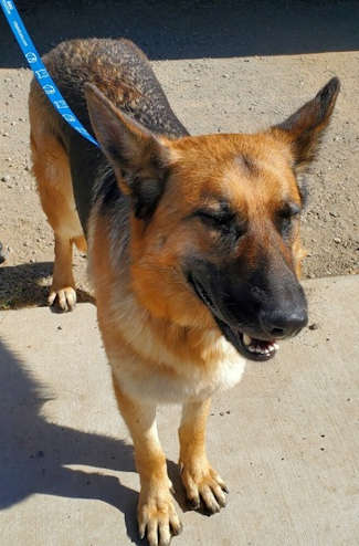
‘Kubota’
“Kubota” is a 4-year-old male German shepherd with a short brown coat.
He has been neutered.
He is dog No. 50184421.

‘Little Boy’
“Little Boy” is a male American pit bull terrier mix with a short tan coat.
He has been neutered.
He is dog No. 50075256.

‘Luciano’
“Luciano” is a male Siberian husky mix with a short black and white coat.
He has been neutered.
He is dog No. 50596272.
‘Mamba’
“Mamba” is a male Siberian husky mix with a gray and cream-colored coat.
He has been neutered.
He is dog No. 49520569.

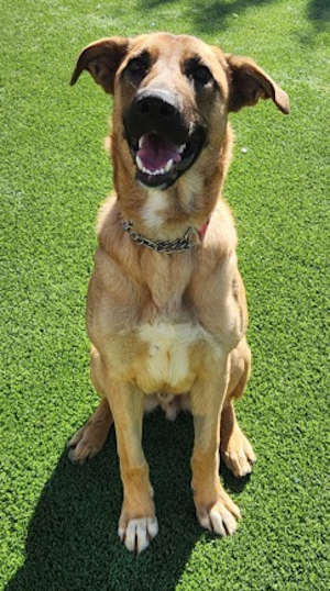
‘Matata’
“Matata” is male shepherd mix with a tan coat.
He has been neutered.
He is dog No. 50176912.
‘Maverick’
“Maverick” is a male pit bull-border collie mix with a short black and white coat.
He has been neutered.
He is dog No. 51027806.
‘Maya’
“Maya” is a female German shepherd with a black and tan coat.
She has been spayed.
She is dog No. 50428151.

‘Mikey’
“Mikey” is a male German shepherd mix with a short brown and tan coat.
He has been neutered.
He is dog No. 51012855.
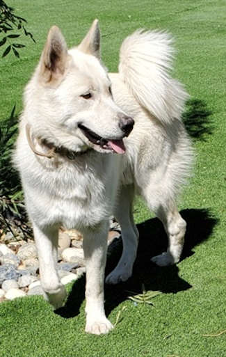
‘Molly’
“Molly” is a female Samoyed mix with a long white coat.
She has been spayed.
She is dog No. 50933031.

‘Noah’
“Noah” is a male pit bull terrier mix with a short white coat.
He has been neutered.
He is dog No. 51286102.
‘Paige’
“Paige” is a female American pit bull mix with a short brown coat.
She has been spayed.
She is dog No. 51194668.

‘Poppa’
“Poppa” is a 3-year-old male American pit bull terrier mix with a short red and white coat.
He has been neutered.
He is dog No. 50773597.
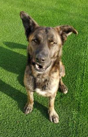
‘Rascal’
“Rascal” is a male shepherd mix with a black and brown coat.
He has been neutered.
He is dog No. 50806384.
‘Reese’
“Reese” is a female German shepherd with a black and an coat.
She has been spayed.
She is dog No. 50884542.

‘Snowball’
“Snowball is a 1 and a half year old male American Staffordshire terrier mix with a short white coat.
He has been neutered.
He is dog No. 49159168.
‘Terry’
“Terry” is a handsome male shepherd mix with a short brindle coat.
He gets along with other dogs, including small ones, and enjoys toys. He also likes water, playing fetch and keep away.
Staff said he is now getting some training to help him build confidence.
He is dog No. 48443693.
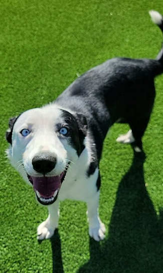
‘Trike’
“Trike” is a male border collie-Australian shepherd mix with a black and white coat and blue eyes.
He has been neutered.
He is dog No. 51029972.

‘Willie’
“Willie” is a male German shepherd mix with a black and tan coat.
He has been neutered.
He is dog No. 50596003.
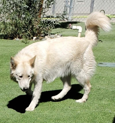
‘Zeus’
“Zeus” is a male Samoyed mix with a long white coat.
He has been neutered.
He is dog No. 50933068.
Email Elizabeth Larson at