 How to resolve AdBlock issue?
News
- Details
- Written by: Rachel Hoover
Scientists recently named a mesa-like lunar mountain that towers above the landscape carved by craters near the Moon’s South Pole.
This unique feature will now be referred to as “Mons Mouton,” after NASA mathematician and computer programmer Melba Roy Mouton (MOO-tawn).
Members of NASA’s Volatiles Investigating Polar Exploration Rover, or VIPER, mission proposed the name to the International Astronomical Union, or IAU.
The flat-topped mountain is adjacent to the western rim of the Nobile Crater, on which VIPER will land and explore during its approximately 100-day mission as part of NASA’s Artemis program.
The IAU theme for naming mountains (mons) on the Moon focuses on “scientists who have made outstanding or fundamental contributions to their fields.”
The lunar landmark naming honors and recognizes Mouton’s life, her accomplishments as a computer scientist, and her contributions to NASA’s missions.
“Melba Mouton was one of our pioneering leaders at NASA,” said Sandra Connelly, the acting associate administrator for science at NASA Headquarters in Washington. “She not only helped NASA take the lead in exploring the unknown in air and space, but she also charted a path for other women and people of color to pursue careers and lead cutting-edge science at NASA.”
Mouton was first employed at NASA’s Goddard Space Flight Center in Greenbelt, Maryland, in 1959, just a year after the space agency was established.
She became the head mathematician who led a group of "human computers," who tracked the Echo 1 and 2 satellites, launched into Earth’s orbit in 1960 and 1964, respectively.
A few years later, in 1961, Mouton was the head programmer responsible for the Mission and Trajectory Analysis Division's Program Systems Branch — the team who coded computer programs used to calculate spacecraft locations and trajectories, giving NASA the ability to track spacecraft while in orbit.
Before retiring in 1973, after a career at NASA that spanned 14 years, Mouton had become the assistant chief of research programs for the Trajectory and Geodynamics Division at Goddard.
In appreciation of her dedicated service and outstanding accomplishments, which culminated in the successful Apollo 11 Moon landing on July 20, 1969, she was recognized with an Apollo Achievement Award.
As NASA prepares to send astronauts to the lunar surface, including the first woman to set foot on the Moon, Mons Mouton is among one of the 13 candidate landing regions for Artemis III.
The wide, relatively flat-topped mountain, about the size of the state of Delaware, was created over billions of years by lunar impacts, which sculpted it out of its surroundings.
As a result, Mons Mouton stands as tall as Denali — the tallest mountain in North America — approximately 20,000 feet higher than its neighboring features on the Moon’s South Pole.
Because it is relatively untouched by bombardments, scientists believe Mons Mouton is much more ancient — possibly billions of years older than its surroundings.
A ring of huge craters — evidence of its pulverizing past — lie around its base; some with cliff-like edges, descending into areas of permanent darkness. Its rolling hilltop is peppered with smaller rocks and pebbles as well as lots of enticing craters that are frequently blanketed in freezing, shifting shadows.
“Mons Mouton represents a great spot for VIPER — our solar-powered Moon rover that we’ll drive and conduct science in near real-time,” said Dr. Sarah Noble, VIPER program scientist at NASA Headquarters in Washington. “It features high sunny spots, it’s relatively flat, satellite data shows signs of water ice, and it allows long stretches of direct communications with our ground station on Earth.”
VIPER will be the first resource mapping mission beyond Earth. It will search at and below the lunar surface to determine the location and concentration of any ice could eventually be harvested to sustain human exploration on the Moon, Mars, and beyond and will help advance scientific exploration of the Moon by helping to understand how water is created and deposited throughout the solar system. VIPER is planned for delivery to the Moon in late 2024 under NASA’s Commercial Lunar Payload Services (CLPS) initiative.
Rachel Hoover works for NASA's Ames Research Center.
- Details
- Written by: LAKE COUNTY NEWS REPORTS
These annual surveys offer, “estimates of tree mortality and damage and depict broad mortality trends.”
On May 3, 2022, the Lake County Board of Supervisors proclaimed a local emergency due to pervasive tree mortality.
In the ensuing months, Napa and Mendocino counties likewise declared states of emergency, recognizing what is a growing crisis in much of the state of California.
United States Forest Service data have depicted truly troubling trends with tree mortality.
In 2019, the Forest Service estimated 1,000 Lake County acres were affected by tree mortality. The estimated number of dead trees was 3,000.
Those estimates have exponentially grown in the time since:
• 2019: 1,000 acres, 3,000 dead trees;
• 2021: 21,000 acres, 331,000 dead trees;
• 2022: 31,000 acres, 590,000 dead trees.
“The U.S. Forest Service’s report shows catastrophic tree mortality across most of Northern California,” said Board of Supervisors Chair Jessica Pyska. “We have been hard at work on this problem in Lake County since 2021, and declared the first tree mortality emergency back in May. Since, we have developed a coalition surrounding this topic with regional counties, and assisted Napa and Mendocino with their emergency declarations.”
A 2022 windshield survey identified approximately 4,000 dead and dying trees near Lake County roadways and evacuation routes, alone.
Dr. Michael Jones, the University of California Cooperative Extension’s Forest Advisor for Lake County and a trained entomologist, said removal of dead and dying trees is critical to mitigating multispecies bark beetle infestation.
Costs for remediation of the highest priority areas, alone, are expected to exceed $12 million.
County officials and partners are reported to be heavily engaged in efforts to secure funding.
“We remain relentless in our project development to treat areas of high concern, and seeking funding from every available source,” said Pyska. “This report confirms everything we have been saying and should garner the attention and urgency that is needed.”
- Details
- Written by: CALIFORNIA HIGHWAY PATROL
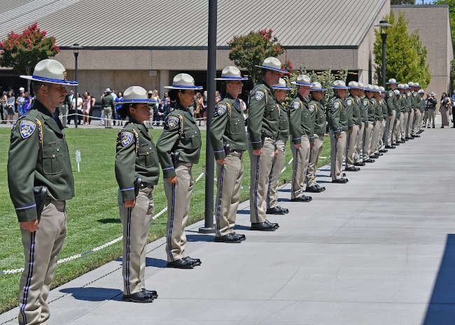
The California Highway Patrol welcomed 82 new officers to the CHP family, during Friday’s graduation ceremony at the CHP Academy in West Sacramento.
Less than one year ago, the CHP launched its “Join the CHP 1,000” campaign, with the goal of hiring 1,000 new officers.
These newly graduated officers bring the CHP closer to attaining its goal.
“It’s my honor to welcome these officers to the CHP and thank them for stepping up to serve our state,” said Gov. Gavin Newsom. “With a goal of hiring 1,000 new CHP officers in the coming years, we’re investing in outreach to a diverse pool of candidates committed to protecting their fellow Californians and making a positive impact in our communities.”
“The women and men of the CHP take great pride in the level of service we provide to the community,” said Commissioner Sean Duryee. “It is imperative we bring on the next generation of exemplary officers to continue that tradition.”
For more information about the “Join the CHP 1,000” campaign, or to apply, visit www.JoinTheCHP1000.com or call the statewide Recruitment Unit at 916-843-4300.

- Details
- Written by: Ellie Broadman, University of Arizona and Darrell Kaufman, Northern Arizona University
Over the past century, the Earth’s average temperature has swiftly increased by about 1 degree Celsius (1.8 degrees Fahrenheit). The evidence is hard to dispute. It comes from thermometers and other sensors around the world.
But what about the thousands of years before the Industrial Revolution, before thermometers, and before humans warmed the climate by releasing heat-trapping carbon dioxide from fossil fuels?
Back then, was Earth’s temperature warming or cooling?
Even though scientists know more about the most recent 6,000 years than any other multimillennial interval, studies on this long-term global temperature trend have come to contrasting conclusions.
To try to resolve the difference, we conducted a comprehensive, global-scale assessment of the existing evidence, including both natural archives, like tree rings and seafloor sediments, and climate models. Our results, published Feb. 15, 2023, suggest ways to improve climate forecasting to avoid missing some important slow-moving, naturally occurring climate feedbacks.
Global warming in context
Scientists like us who study past climate, or paleoclimate, look for temperature data from far back in time, long before thermometers and satellites.
We have two options: We can find information about past climate stored in natural archives, or we can simulate the past using climate models.
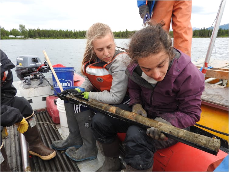
There are several natural archives that record changes in the climate over time. The growth rings that form each year in trees, stalagmites and corals can be used to reconstruct past temperature. Similar data can be found in glacier ice and in tiny shells found in the sediment that builds up over time at the bottom of the ocean or lakes. These serve as substitutes, or proxies, for thermometer-based measurements.
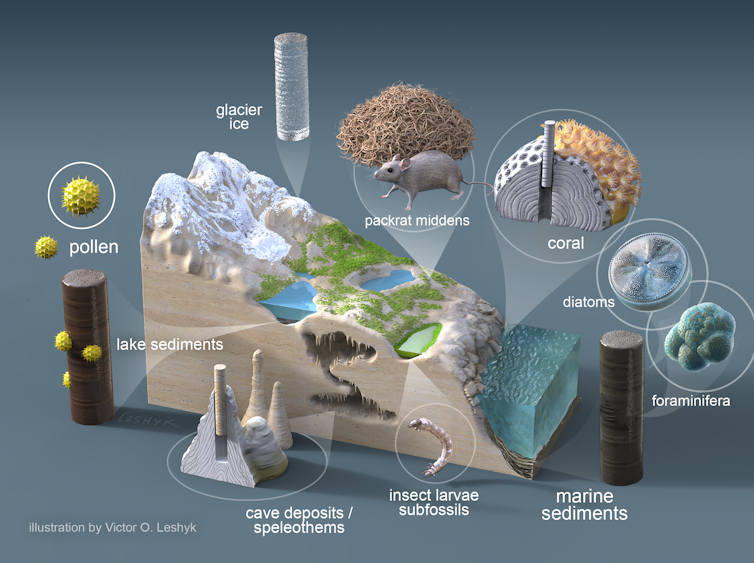
For example, changes in the width of tree rings can record temperature fluctuations. If temperature during the growing season is too cold, the tree ring forming that year is thinner that one from a year with warmer temperatures.
Another temperature proxy is found in seafloor sediment, in the remains of tiny ocean-dwelling creatures called foraminifera. When a foraminifer is alive, the chemical composition of its shell changes depending on the temperature of the ocean. When it dies, the shell sinks and gets buried by other debris over time, forming layers of sediment at the ocean floor. Paleoclimatologists can then extract sediment cores and chemically analyze the shells in those layers to determine their composition and age, sometimes going back millennia.
Climate models, our other tool for exploring past environments, are mathematical representations of the Earth’s climate system. They model relationships among the atmosphere, biosphere and hydrosphere to create our best replica of reality.
Climate models are used to study current conditions, forecast changes in the future and reconstruct the past. For example, scientists can input the past concentrations of greenhouse gases, which we know from information stored in tiny bubbles in ancient ice, and the model can use that information to simulate past temperature. Modern climate data and details from natural archives are used to test their accuracy.
Proxy data and climate models have different strengths.
Proxies are tangible and measurable, and they often have a well-understood response to temperature. However, they are not evenly distributed around the world or through time. This makes it difficult to reconstruct global, continuous temperatures.
In contrast, climate models are continuous in space and time, but while they are often very skillful, they will never capture every detail of the climate system.
A paleo-temperature conundrum
In our new review paper, we assessed climate theory, proxy data and model simulations, focusing on indicators of global temperature. We carefully considered naturally occurring processes that affect the climate, including long-term variations in Earth’s orbit around the Sun, greenhouse gas concentrations, volcanic eruptions and the strength of the Sun’s heat energy.
We also examined important climate feedbacks, such as vegetation and sea ice changes, that can influence global temperature. For example, there is strong evidence that less Arctic sea ice and more vegetation cover existed during a period around 6,000 years ago than in the 19th century. That would have darkened the Earth’s surface, causing it to absorb more heat.

Our two types of evidence offer different answers regarding the Earth’s temperature trend over the 6,000 years before modern global warming. Natural archives generally show that Earth’s average temperature roughly 6,000 years ago was warmer by about 0.7 C (1.3 F) compared with the 19th century median, and then cooled gradually until the Industrial Revolution. We found that most evidence points to this result.
Meanwhile, climate models generally show a slight warming trend, corresponding to a gradual increase in carbon dioxide as agriculture-based societies developed during the millennia after ice sheets retreated in the Northern Hemisphere.
How to improve climate forecasts
Our assessment highlights some ways to improve climate forecasts.
For example, we found that models would be more powerful if they more fully represented certain climate feedbacks. One climate model experiment that included increased vegetation cover in some regions 6,000 years ago was able to simulate the global temperature peak we see in proxy records, unlike most other model simulations, which don’t include this expanded vegetation.
Understanding and better incorporating these and other feedbacks will be important as scientists continue to improve our ability to predict future changes.![]()
Ellie Broadman, Postdoctoral Research Associate in Climate Science, University of Arizona and Darrell Kaufman, Professor of Earth and Environmental Sciences, Northern Arizona University
This article is republished from The Conversation under a Creative Commons license. Read the original article.