How to resolve AdBlock issue?
Refresh this page
How to resolve AdBlock issue?
Refresh this page
Lake County News,California
  • Home
    • Registration Form
  • News
    • Education
    • Veterans
    • Community
      • Obituaries
      • Letters
      • Commentary
    • Police Logs
    • Business
    • Recreation
    • Health
    • Religion
    • Legals
    • Arts & Life
    • Regional
  • Calendar
  • Contact us
    • FAQs
    • Phones, E-Mail
    • Subscribe
  • Advertise Here
  • Login
How to resolve AdBlock issue?
Refresh this page

News

Helping Paws: Huskies, Aussies and shepherds

Details
Written by: Elizabeth Larson
Published: 09 November 2025

LAKE COUNTY, Calif. — Lake County Animal Care and Control has another group of new dogs available this week.

The dogs available for adoption this week include mixes of Australian shepherd, Chihuahua, chow, German shepherd, husky, Labrador Retriever, pit bull terrier, Rottweiler, terrier and shepherd.

Dogs that are adopted from Lake County Animal Care and Control are either neutered or spayed, microchipped and, if old enough, given a rabies shot and county license before being released to their new owner. License fees do not apply to residents of the cities of Lakeport or Clearlake.

Those animals shown on this page at the Lake County Animal Care and Control shelter have been cleared for adoption.

Call Lake County Animal Care and Control at 707-263-0278 or visit the shelter online for information on visiting or adopting.

The shelter is located at 4949 Helbush in Lakeport.

Email Elizabeth Larson at This email address is being protected from spambots. You need JavaScript enabled to view it.. Follow her on Twitter, @ERLarson, and on Bluesky, @erlarson.bsky.social. Find Lake County News on the following platforms: Facebook, @LakeCoNews; X, @LakeCoNews; Threads, @lakeconews, and on Bluesky, @lakeconews.bsky.social. 

Kennel#18 Eva 's preview photo
Kennel#18 Eva

Kennel#15 Scooby's preview photo
Kennel#15 Scooby

Kennel#24 Cowboy's preview photo
Kennel#24 Cowboy

 Kennel#3 Bandit's preview photo
Kennel#3 Bandit

Kennel#26 Blair's preview photo
Kennel#26 Blair

Kennel#4 Amore's preview photo
Kennel#4 Amore

Kennel#22 Azula's preview photo
Kennel#22 Azula

Kennel#17 Trina's preview photo
Kennel#17 Trina

Kennel#31 Bear's preview photo
Kennel#31 Bear

Kennel#32 (Bluey)'s preview photo
Kennel#32 (Bluey)

Kennel#12 Kora's preview photo
Kennel#12 Kora

Kennel#5 Hank's preview photo
Kennel#5 Hank

Kennel#6 Saphire's preview photo
Kennel#6 Saphire

Kennel#27 Spyro's preview photo
Kennel#27 Spyro

Kennel#25 Murphey's preview photo
Kennel#25 Murphey

Kennel#20 Duke's preview photo
Kennel#20 Duke

Kennel#21 Hanson's preview photo
Kennel#21 Hanson

Kennel#19a Petunia's preview photo
Kennel#19a Petunia

Kennel#11(Little Momma)'s preview photo
Kennel#11(Little Momma)

Kennel#23 Sugar's preview photo
Kennel#23 Sugar

Kennel#8 Dash's preview photo
Kennel#8 Dash

Kennel#34 Pawla's preview photo
Kennel#34 Pawla

Kennel#30 Junior's preview photo
Kennel#30 Junior

Kennel#19b(Pico)'s preview photo
Kennel#19b(Pico)

Kennel#16 Bernard's preview photo
Kennel#16 Bernard

Kennel#9's preview photo
Kennel#9
 
Kennel#14a's preview photo
Kennel#14a

Kennel#14b's preview photo
Kennel#14b

Kennel#13's preview photo
Kennel#13

Kennel#7's preview photo
Kennel#7


Barking orders and fighting crime: CHP’s newest four-legged crime fighters officially promoted to K-9 officers

Details
Written by: LAKE COUNTY NEWS REPORTS
Published: 09 November 2025
Officer Michael Galvez and K-9 Oso. Photo courtesy of the California Highway Patrol.

Four additional specialized K-9 teams will join the California Highway Patrol to improve public safety and provide service to Californians.

This graduating class consisted of three Belgian Malinois — Judge, Jag and Jury — and one Dutch Shepherd, Oso.

Each is trained to apprehend offenders, detect illegal drugs and enhance officer and public safety. 

While on the force, these canines will play a critical role in criminal apprehension and controlled substance detection in Californian communities. 

Additionally, they will accompany CHP officers to safeguard neighborhoods as patrol canines.

“Police K-9s have proven their usefulness time and again in the situations officers face daily,” CHP Commissioner Sean Duryee. “They are hardworking, loyal partners who wake up each day ready to serve. Each of these specialized teams has dedicated time and effort to succeed on the streets, and we are excited to welcome them to our team.” 

“Our newly trained canines mark another success in furthering our efforts to bend the crime rates down and increase safety in communities,” said Gov. Gavin Newsom. “We will continue working strategically to build on our public safety investments and progress.”

The new K-9 teams are Officer Joshua Walker and K-9 Jury, Inland Division; Officer Christopher Partlow and K-9 Judge, Northern Division; Officer Christopher Keeler and K-9 Jag, Central Division; and Officer Michael Galvez and K-9 Oso, Central Division. 

Over the past 11 weeks, the four K-9 teams completed more than 400 hours of intensive training, meeting the standards set by the California Commission on Peace Officer Standards and Training. 

The K-9s, trained in criminal apprehension and narcotics detection, also known as Patrol and Narcotics Detection Canines, received their official certification on Friday, Nov. 7, during a graduation ceremony at the CHP Academy in West Sacramento.

Each K-9 handler is an experienced CHP officer with seven to 15 years of service. Handlers were carefully paired with their canine partners based on temperament, skill and personality. 

Throughout training, the teams built strong bonds of trust and communication that will support them throughout their careers.

Following this graduation, the new K-9 teams will report to their assigned CHP Area offices to assist with patrol duties and respond to calls for service in the Northern, Central and Inland Divisions.

With this graduating class, the second of 2025, the CHP now deploys 53 K-9 teams statewide:

• 37 patrol and narcotics detection canine teams;
• 9 patrol and explosives detection canine teams;
• 5 explosives detection canine teams;
• 2 narcotics detection teams.

From January through September 2025, CHP K-9 teams seized nearly 7,000 pounds of methamphetamine, 5,000 pounds of cocaine, 250 pounds of heroin, 750 pounds of fentanyl and 213 firearms, underscoring their critical role in combating drug trafficking and firearm-related crime.

To maintain peak performance, each team completes at least eight hours of ongoing training each week, ensuring readiness for the diverse situations they encounter in the field.


Officer Christopher Partlow and K-9 Judge. Photo courtesy of the California Highway Patrol.

National 211 hotline calls for food assistance quadrupled in a matter of days, a magnitude typically seen during disasters

Details
Written by: Matthew W. Kreuter, Washington University in St. Louis and Rachel Garg, Washington University in St. Louis
Published: 09 November 2025

Sharp spikes in calls for food assistance are rare outside of natural disasters. AP Photo/Eric Gay

Between January and mid-October 2025, calls to local 211 helplines from people seeking food pantries in their community held steady at nearly 1,000 calls per day.

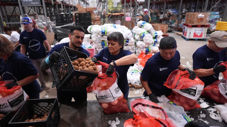
But as the government shutdown entered its fourth week in late October, states began to warn residents that Supplemental Nutrition Assistance Program benefits, sometimes known as food stamps, would likely be affected. Nearly 42 million Americans receive SNAP benefits each month.

Over the next several days, calls to 211 from people seeking food pantries doubled to over 2,200 per day. Then on Oct. 26, the Trump administration announced that SNAP benefits would not be arriving as scheduled in November. The next day, food pantry calls skyrocketed to 3,324. The following day, calls reached 3,870. By Wednesday, it was 4,214.

We are public health scientists specializing in health communication and unmet social needs. We and our colleagues have been working closely with the 211 network of helplines across the U.S. for 18 years.

Excluding disasters, sudden surges of this magnitude in requests for food or any other need are rare at 211s, and can signal both public worry and need, as happened in the first weeks of the COVID-19 pandemic.

What is 211?

Like 911 for emergencies, 211 is a national three-digit dialing code, launched in 2000, that connects callers to information specialists at the nearest local 211 helpline. Those specialists listen to callers’ needs and provide them with referrals to health and social service providers near them that may be able to help.

Every call to 211 is classified by the need of the caller, such as shelter, rent, utilities or food – each of which has its own code.

Callers are disproportionately women, most of whom have children or teens living in their homes. Most don’t make enough money to make ends meet. They call 211 seeking help paying rent or utility bills, getting food to feed their family, or securing household necessities like a winter coat for a child, or a mattress.

The hotline does not solve these problems for callers, but 211 information specialists use the most current local information available to refer callers to service agencies that are most likely to have resources to help.

The 211 network is the closest thing the U.S. has to a real-time surveillance system of the needs of low-income Americans.

There are roughly 200 state and local 211s in the U.S., and on an average day they will collectively field between 35,000 and 40,000 requests for help. Each request is coded using a taxonomy of over 10,000 need types, is time- and date-stamped, and is linked to the caller’s ZIP code. In addition to phone calls received by their helplines, 211s increasingly track requests they receive online, through their websites. The national network of 211s covers all 50 states and 99% of the U.S. population.

It’s encouraging to us that with each passing year of giving talks and lectures about 211, more and more audience members raise their hands when asked if they’ve ever heard of 211. But it’s far from 100%. If you are one of those with your hand down, here’s what you need to know.

Food banks around the country are having trouble keeping their shelves stocked.

Gaining local insights

Our team aims to deploy the latest methods from data science, predictive analytics and artificial intelligence to detect trends in critical needs sooner and at a more localized level, increasing the speed and efficiency of getting needed help to local community members.

Our research has described the needs of callers who reach out to 211, community capacity to respond to callers’ needs, the ability of 211 to detect rapid changes in community needs, and the benefits of integrating health referrals into 211s.

When we saw food requests rising sharply in late October, we reached out to local leaders at 211 call centers to get insights into what they were hearing from callers.

Robin Pokojski, vice president of 211 and community partnerships at United Way of Greater St. Louis, reported that with all the uncertainty around SNAP benefits, callers were initially “anticipating” a need for food pantries. Tiffany Olson, who directs essential services at Crisis Connections and its 211 call center in Washington state, shared that even callers who rely heavily on their SNAP benefits sometimes need to use food banks as a supplement.

Those callers know that pivoting to rely solely on food banks probably won’t be enough to meet their food needs in full. They realize that food pantries and food banks will be more heavily burdened if SNAP benefits are unavailable.

Increasing the impact of 211 data

The trove of daily data on the needs of U.S. callers to 211 at the ZIP code level is unparalleled. Yet for years it was virtually invisible to anyone who didn’t work at a 211 hotline.

Even for people who work and volunteer within the 211 system, formal reporting on caller needs within a community was minimal, such as a one-page annual summary.

That changed in 2013.

Working with 211s across the country, our team created 211 Counts, a collection of user-friendly, public-facing data dashboards for local 211s across the U.S.

The dashboards allow users to explore the top needs in their community, see which neighborhoods are affected most and understand how needs are changing over time. The data can be sorted by legislative districts, school districts and counties to make the findings more relevant to different audiences.

Data on 211 requests are updated each night. Now in its 12th year, 211 Counts includes data on over 90 million requests from 211 callers in all or parts of 44 states. The local dashboards have been visited millions of times.

211 as an early-warning system

This is not the first time data collected through 211 hotlines has detected early signs of trouble for some Americans. Just weeks ago, we found that calls from people seeking assistance making car payments have been increasing steadily for five months, with daily calls peaking in October, at nearly twice the rate of May 2025.

Before that, 211s were months ahead of news reporting in seeing public distress associated with the 2022 baby formula shortage, the 2016 Flint water crisis and the 2007 subprime mortgage crisis.

When requests for major needs like food increase three- to fourfold overnight, every local 211 is likely to register this abrupt change.

But when less frequent needs, such as car payment assistance, creep up slowly, with an extra call here and there over several months, it’s unlikely that any local 211 hotline would notice.

That’s when the advantages of big data are greatest. By combining caller needs from 211s across the country, patterns emerge that would otherwise be missed. New data science tools are rapidly improving the speed and accuracy of detecting slight changes. When community and national leaders are made aware of potential rising threats, those threats can be tracked more closely and responses prepared.

It’s easy to lose sight of the fact that each data point is a hungry child or a worried parent.

Hotlines and food banks and food pantries need support in this moment to feed people. But most local safety net systems struggle to meet their community’s needs all the time. Data that documents the magnitude of need won’t fix the scarcity of local assistance, but it can help guide communities in allocating limited resources.The Conversation

Matthew W. Kreuter, Kahn Family Professor of Public Health, Washington University in St. Louis and Rachel Garg, Assistant Professor of Public Health, Washington University in St. Louis

This article is republished from The Conversation under a Creative Commons license. Read the original article.

Space News: With more Moon missions on the horizon, avoiding crowding and collisions will be a growing challenge

Details
Written by: Mariel Borowitz, Georgia Institute of Technology and Brian Gunter, Georgia Institute of Technology
Published: 08 November 2025

Many companies and space agencies want to send satellites to orbit the Moon, and crowding could become a concern. European Space Agency ©ESA, CC BY-NC

Interest in the Moon has been high – just in the past two years there have been 12 attempts to send missions to the Moon, nearly half of which private companies undertook. With so much activity, it’s important to start thinking about coordination and safety.

To some, this concern may seem premature. About 10 to 20 missions are headed to the Moon in the next few years – far short of the thousands of satellites operating in Earth’s orbit. And the area around the Moon, referred to as cislunar space, is very large. Earth’s orbital area is often considered to extend from near Earth out to geostationary orbit, where a spacecraft orbits at a speed that makes it appear stationary from the Earth’s surface.

Cislunar space extends from geostationary orbit out to the Moon – an area with a volume 2,000 times larger than Earth’s orbital area. This size discrepancy seems to suggest crowding around the Moon may not be an immediate concern.

A diagram showing Earth, with three rings around it denoting, from the innermost outwards, low-Earth orbit, medium-Earth orbit, high-Earth orbit and geostationary orbit. it also shows the Moon and the L1 point in the space between Earth and the Moon.
Cislunar space refers to the space between Earth’s geostationary orbit and the Moon. Many Worlds, CC BY-NC

However, missions tend to choose from a select set of stable orbits around the Moon, so the vastness of cislunar space may be misleading when thinking about whether missions will intersect. Also, most government sensors that track spacecraft aren’t capable of consistently detecting and monitoring objects so far away from Earth, partly due to the glare from the Moon itself.

That uncertainty, combined with the high cost of lunar missions, makes operators more likely to move their spacecraft to avoid a collision, even when the probability of a collision is quite low.

As an interdisciplinary team combining space policy and astrodynamics expertise, we’ve been studying how companies and space agencies could manage traffic in lunar orbit without unnecessary maneuvers. Our research, published in March 2025 in the Journal of Spacecraft and Rockets, shows that due to the popularity of certain orbits and the uncertainties regarding each spacecraft’s location, potential collisions become an issue surprisingly quickly.

Our simulations show that with only 50 satellites in lunar orbit, each of those satellites will need to maneuver four times a year on average to avoid a potential crash – a significant cost in terms of fuel as well as potential disruption to mission objectives. Lunar orbit could easily reach that number of satellites within a decade if activity continues to increase.

A map showing lots of dots on the lunar surface.
With interest in the Moon rising, companies and space agencies will need to coordinate to avoid disruptions. This map shows all successful or semi-successful soft landings on the Moon, with eight taking place in the past decade. EnzoTC/Wikimedia Commons, data taken from https://nssdc.gsfc.nasa.gov/planetary/lunar/lunar_artifact_impacts.html and https://trek.nasa.gov/moon/

Maneuvering satellites

Countries’ reports on their current operations in lunar orbit seem to support our finding that congestion around the Moon is quickly becoming a significant issue. In 2023, the Indian Space Research Organization reported it had maneuvered its Chandrayaan-2 spacecraft three times in four years, even though only six spacecraft orbited the Moon in that time.

Better monitoring and coordination between different space agencies could prevent congestion and keep countries from having to regularly move their spacecraft.

Monitoring cislunar space is not just important for safety – it can also help support national security. Multiple countries have weapons that can destroy satellites, and some in the space community are concerned that space weapons could be placed in cislunar space to escape detection. The U.S. Space Force is considering the potential security dimensions of cislunar space.

The U.S. currently has significant gaps in its ability to monitor this region, and Mariel’s research suggests that developing this capability – referred to as cislunar space domain awareness – should be a priority for national security. Improved monitoring would help the U.S. military observe activity in cislunar space, gather intelligence and assess potential threats.

Solutions in progress

Several research programs are experimenting in this area. The Air Force Research Laboratory is funding a program called Oracle that is developing multiple systems to improve the U.S. ability to monitor cislunar space.

The first Oracle satellite is expected to launch in 2027. It will be located at a Lagrange point, which is a spot between the Earth and the Moon where the gravitational pull of each object keeps the spacecraft in a stable position. From there, it can detect objects in cislunar space that sensors on Earth cannot see.

The Air Force Research Laboratory’s Oracle satellite would help the U.S. monitor activity in cislunar space.

Improving monitoring is only one part of the solution. Entities sending missions to the Moon, including governments and companies, will need to share the locations of their operational missions and coordinate to avoid predicted collisions.

A NASA program dedicated to tracking and assessing lunar traffic is helping to facilitate this effort. The program compares individual operators’ information about their spacecraft’s current and future planned location to identify potential close approaches. In the future, this type of coordination could improve safety, when combined with sensor observations from systems like Oracle.

Countries and companies planning missions to the Moon could also try to coordinate before they launch their systems, so no missions end up operating too close together.

The Outer Space Treaty, a set of basic principles developed early in the space age, requires that countries avoid harmfully interfering with other countries’ activities, but the treaty doesn’t outline how to do this.

The United Nations Committee on the Peaceful Uses of Outer Space formed a team in February 2025 that hopes to address these and other coordination issues on the Moon.

With government and commercial missions to the Moon increasing, and NASA’s next human mission to the Moon planned for early 2026, countries will need to work together to protect everyone’s interest in the Moon.The Conversation

Mariel Borowitz, Associate Professor of International Affairs, Georgia Institute of Technology and Brian Gunter, Associate Professor of Aerospace Engineering, Georgia Institute of Technology

This article is republished from The Conversation under a Creative Commons license. Read the original article.

  1. Agencies and organizations respond to delay in food benefits
  2. Registrar’s office issues updates on vote count progress
  3. Clearlake Animal Control: ‘Beezy’ and the dogs
  • 102
  • 103
  • 104
  • 105
  • 106
  • 107
  • 108
  • 109
  • 110
  • 111
How to resolve AdBlock issue?
Refresh this page