How to resolve AdBlock issue?
News
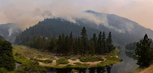
The fire, burning since Wednesday afternoon, remained at 83 acres on Friday, with containment up to 45%, said Lake County Fire Chief Willie Sapeta.
Early Saturday, one zone in Lake County’s Zonehaven system remained under mandatory evacuation, Zone CLE-E157, which contains everything in the city of Clearlake to the south of 18th Avenue and east of Highway 53 except for Adventist Health Clear Lake Hospital.
City Manager Alan Flora said he visited the fire scene on Friday morning and there were a few hotspots to deal with but little fire activity.
He said the hope is that evacuees can return home on Sunday, but added that a lot of work by Pacific Gas and Electric to replace damaged power infrastructure remains to be done.
Overall, Sapeta — who was one of the first on scene at the incident, which is estimated to have destroyed 137 structures, including 56 homes — said the progress on the fire was “looking good.”
What’s not looking good is the prospects for the city of Clearlake to get help in the complex task of recovery.
City officials have acknowledged that because the fire doesn’t meet the thresholds for state and federal disaster assistance — as has been the case with most of Lake County’s destructive fires — much of the multimillion dollar recovery process and its cost could end up falling on the city.
Flora said the state is going to provide very limited resources to the city for the incident.
He said the city will get a hazmat team from the Department of Toxic Substances Control, which is waiting on the county of Lake to declare a public health emergency so the phase one cleanup can begin.
“Hopefully that will be soon,” said Flora.
As of Friday, that public health emergency had not been agendized by the Board of Supervisors for its next meeting on Tuesday.
Flora said the state hazmat team won’t address any debris clean up from homes or vehicles.
He said the city is working with Assemblywoman Cecilia Aguiar-Curry and Sen. Mike McGuire to try to piece together a solution or the cleanup, but he said so far they have no solid plan.
“We are still working to see if we can get any short term housing assistance for those that lost their homes, but nothing happening yet from the state on that front,” Flora said.
He also didn’t have a dollar estimate for damage.
Flora said that estimate has to be submitted by the California Office of Emergency Services by Wednesday, “so it will start coming together soon.”
Email Elizabeth Larson at
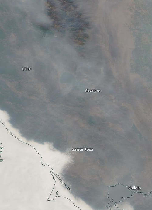
LAKE COUNTY, Calif. — Lake County has continued to experience smoky skies this week due to regional wildland fires and the Cache fire in Clearlake, but conditions are expected to begin to improve over the weekend.
The Lake County Air Quality Management District said the air basin continues to be impacted.
Calmer winds along with relatively stable air have settled over the region. The district said the lack of mixing and westerly winds resulted in all areas of Lake County experiencing intermittent air quality impacts from “unhealthy for sensitive groups” to “hazardous” on Friday.
For Saturday, the air quality forecast will range from “unhealthy for sensitive groups” (Air Quality Index of 101 to 150) to “unhealthy” (AQI of 151-200) with areas at higher elevations experiencing the most smoke impact.
The district said current weather models indicate that there will be some smoke clearing on Saturday and significant clearing on Sunday. Most areas should reach the “moderate” or “good” thresholds.
The National Weather Service forecast calls for widespread haze during the day on Saturday, with clearer conditions at night and on Sunday as light winds move over the area.
Visit the Lake County Air Quality Management District’s website and follow the Quick Links for Air Monitoring for current smoke and air quality conditions.
Northern California National Forests, CDFW lands to close temporarily due to extreme fire conditions
The USDA Forest Service has announced the temporary closure of nine national forests in northern California effective Sunday, Aug. 22, at 11:59 p.m. through Monday, Sept. 6 at 11:59 p.m. due to extreme fire conditions.
A 10th forest, the El Dorado National Forest, was closed earlier this week due to wildfire.
In response, the California Department of Fish and Wildlife, or CDFW, will close seven of its properties that lie within or immediately adjacent to USDA Forest Service boundaries during this same period to support emergency response routes, firefighting efforts and protect public safety.
“We understand these closures — even temporary — will significantly impact our hunters, especially with archery deer seasons opening this weekend in many parts of northern California,” said CDFW Director Charlton H. Bonham. “We have a public safety emergency and an environmental crisis on our hands with these wildfires. We thank hunters, anglers and others who cherish these public lands for respecting these closures and allowing firefighters and public safety personnel to secure these areas and help protect our wild places and our rural communities.”
Hunters are urged to check directly with the appropriate land agency about any wildfire-related closures before heading out on hunting trips.
Unfortunately, resident deer tag fees are nonrefundable regardless of land closures due to fire, weather or other natural disasters per the California Code of Regulations, Title 14, Section 708.2(b).
Refunds may be issued to nonresident tag holders (subject to specific requirements) and for select elk, pronghorn antelope and bighorn sheep tags.
Bonham said CDFW is evaluating options to petition the California Fish and Game Commission to refund deer tag fees — and other big game tag fees — for those areas closed due to wildfire conditions.
Land closures announced this week are temporary. California’s deer seasons are just beginning to open. Many of California’s general seasons are still a month or more away from opening.
“Our hope, certainly, is that deer hunters will have the opportunity to hunt at some point and participate in part or all of their favorite seasons,” Bonham said. “But we also are prepared to support our deer, elk, pronghorn and sheep hunters who have done so much for conservation over the years.”
Premium deer tags awarded using a first choice in California’s Big Game Drawing, elk tags, pronghorn antelope tags, and bighorn sheep tags may be returned to CDFW with a request to have preference points reinstated and one preference point awarded for the species for the current hunt year.
To be considered for preference point reinstatement, the tag must be returned (postmarked) prior to the first date the tag is valid for hunting.
Premium deer tags cannot be exchanged, but any hunter that has only been issued one deer tag during the hunting license year may purchase one additional deer tag from the list of available deer tags (PDF).
A complete list of tag return deadlines along with additional information on tag returns, exchanges and preference point eligibility requirements can be found on CDFW’s Hunting Licenses and Tags webpage.
The restrictions apply to all BLM-managed public lands within the boundary of the Central Coast and Ukiah field offices, which are primarily located in Colusa, western Fresno, Glenn, Lake, Marin, Mendocino, Monterey Napa, San Benito, Santa Cruz, Solano, Sonoma and Yolo counties.
The fire orders go into effect now until further notice.
The increased restrictions prohibit campfires, barbecues, or open fires on all public lands, including in developed campgrounds.
Portable stoves with gas, jelled petroleum, or pressurized liquid fuel are still allowed with a valid California campfire permit, available free online at www.readyforwildfire.org/prevent-wildfire/campfire-safety/ and at all BLM, U.S. Forest Service and Cal Fire offices.
California is in a drought with 85 percent of the state in extreme drought. Dry grass, brush and trees ignite and burn extremely quickly.
Taking individual responsibility to reduce wildland fire risk, while recreating on public lands, around homes and communities, before a fire occurs can help keep property, the public and firefighters safe.
Nearly 90% of wildfires in the United States are caused by humans. The public is advised to be extremely careful when recreating outdoors and do the following: always carry a shovel and water and check weather forecasts and fire danger ratings before leaving home.
The following restrictions/limitations are already in place and will continue to be enforced until fire dangers subside:
· No target shooting; use of firearms for hunting is still allowed.
· No smoking, except within an enclosed vehicle or building, or at a designated developed recreation site.
· No tools powered by internal combustion engines (chain saws, lawn mowers, generators, etc.) off established roads or trails.
· No motorized vehicles off established roads or trails.
· No fireworks, including “safe and sane” fireworks.
· No welding or operating acetylene or other torch with open flame, except by special permit.
· No use of explosives, except by special permit.
Visit the BLM California Wildfire Dashboard to see an interactive map of fire restrictions on public lands throughout the state. Information on how to prevent wildfires can be found at www.readyforwildfire.org/.
For specific questions, contact either the Central Coast Field Office at 831-582-2200 or the Ukiah Field Office at 707-468-4000.
Climate change has been accumulating slowly but relentlessly for decades. The changes might sound small when you hear about them – another tenth of a degree warmer, another centimeter of sea level rise – but seemingly small changes can have big effects on the world around us, especially regionally.
The problem is that while effects are small at any time, they accumulate. Those effects have now accumulated to the point where their influence is contributing to damaging heat waves, drought and rainfall extremes that can’t be ignored.
The most recent report from the United Nations’ Intergovernmental Panel on Climate Change is more emphatic than ever: Climate change, caused by human activities like burning fossil fuels, is having damaging effects on the climate as we know it, and those effects are rapidly getting worse.
Earth’s energy imbalance
An excellent example of how climate change accumulates is Earth’s energy imbalance. I am a climate scientist and have a new book on this about to be published by Cambridge University Press.
The Sun bombards Earth with a constant stream of about 173,600 terawatts (that is 12 zeros) of energy in the form of solar radiation. About 30% of that energy is reflected back into space by clouds and reflective surfaces, like ice and snow, leaving 122,100 terawatts to drive all the weather and climate systems around us, including the water cycle. Almost all of that energy cycles back to space – except for about 460 TW.
That remaining 460 TW is the problem we’re facing. That excess energy, trapped by greenhouse gases in the atmosphere, is heating up the planet. That is the Earth’s energy imbalance, or in other words, global warming.
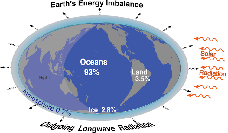
In comparison with the natural flow of energy through the climate system, 460 TW seems small – it’s only a fraction of 1 percent. Consequently, we cannot go outside and feel the extra energy. But the heat accumulates, and it is now having consequences.
To put that in perspective, the total amount of electricity generated worldwide in 2018 was about 2.6 TW. If you look at all energy used around the world, including for heat, industry and vehicles, it’s about 19.5 TW. Earth’s energy imbalance is huge in comparison.
Interfering with the natural flow of energy through the climate system is where humans make their mark. By burning fossil fuels, cutting down forests and releasing greenhouse gases in other ways, humans are sending gases like carbon dioxide and methane into the atmosphere that trap more of that incoming energy rather than letting it radiate back out.
Before the first industries began burning large amounts of fossil fuels in the 1800s, the amount of carbon dioxide in the atmosphere was estimated at around 280 parts per million of volume. In 1958, when Dave Keeling began measuring atmospheric concentrations at Mauna Loa in Hawaii, that level was 310 parts per million. Today, those values have climbed to about 415 parts per million, a 48% increase.
Carbon dioxide is a greenhouse gas, and increased amounts cause heating. In this case, the human increment is not small.
Where does the extra energy go?
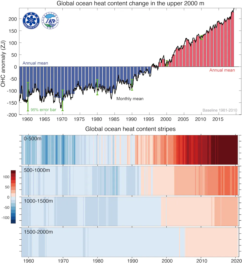
Measurements over time show that over 90% of this extra energy is going into the oceans, where it causes the water to expand and sea level to rise.
The upper layer of the oceans started warming around the 1970s. By the early 1990s, heat was reaching 500 to 1,000 meters (1,640 to 3,280 feet) deep. By 2005, it was heating the ocean below 1,500 meters (nearly 5,000 feet).
Global sea level, measured by flights and satellites, was rising at a rate of about 3 millimeters per year from 1992 to 2012. Since then, it been increasing at about 4 millimeters a year. In 29 years, it has risen over 90 millimeters (3.5 inches).
If 3.5 inches doesn’t sound like much, talk to the coastal communities that exist a few feet above sea level. In some regions, these effects have led to chronic sunny day flooding during high tides, like Miami, San Francisco and Venice, Italy. Coastal storm surges are higher and much more destructive, especially from hurricanes. It’s an existential threat to some low-lying island nations and a growing expense for U.S. coastal cities.
Some of that extra energy, about 13 terawatts, goes into melting ice. Arctic sea ice in summer has decreased by over 40% since 1979. Some excess energy melts land ice, such as glaciers and permafrost on Greenland, Antarctica, which puts more water into the ocean and contributes to sea level rise.
Some energy penetrates into land, about 14 TW. But as long as land is wet, a lot of energy cycles into evapotranspiration – evaporation and transpiration in plants – which moistens the atmosphere and fuels weather systems. It is when there is a drought or during the dry season that effects accumulate on land, through drying and wilting of plants, raising temperatures and greatly increasing risk of heat waves and wildfire.
Consequences of more heat
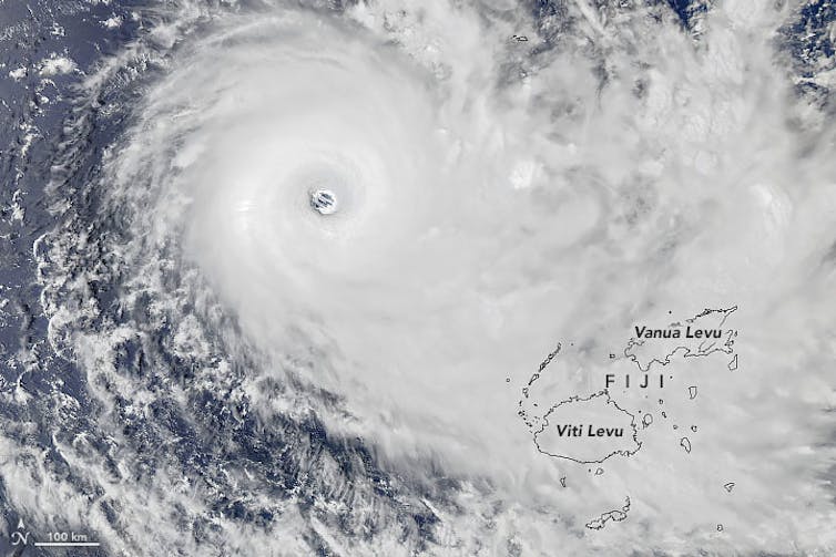
Over oceans, the extra heat provides a tremendous resource of moisture for the atmosphere. That becomes latent heat in storms that supersizes hurricanes and rainstorms, leading to flooding, as people in many parts of the world have experienced in recent months.
Air can contain about 4% more moisture for every 1 degree Fahrenheit (0.55 Celsius) increase in temperature, and air above the oceans is some 5% to 15% moister than it was prior to 1970. Hence, about a 10% increase in heavy rain results as storms gather the excess moisture.
Again, this may not sound like much, but that increase enlivens the updrafts and the storms, and then the storm lasts longer, so suddenly there is a 30% increase in the rainfall, as has been documented in several cases of major flooding.
In Mediterranean climates, characterized by long, dry summers, such as in California, eastern Australia and around the Mediterranean, the wildfire risk grows, and fires can be readily triggered by natural sources, like dry lightning, or human causes.
Extreme events in weather have always occurred, but human influences are now pushing them outside their previous limits.
The straw that breaks the camel’s back syndrome
So, while all weather events are driven by natural influences, the impacts are greatly magnified by human-induced climate change. Hurricanes cross thresholds, levees break and floods run amok. Elsewhere, fires burn out of control, things break and people die.
I call it “The straw that breaks the camel’s back syndrome.” This is extreme nonlinearity, meaning the risks aren’t rising in a straight line – they’re rising much faster, and it confounds economists who have greatly underestimated the costs of human-induced climate change.
The result has been far too little action both in slowing and stopping the problems, and in planning for impacts and building resilience – despite years of warnings from scientists. The lack of adequate planning means we all suffer the consequences.
[The Conversation’s science, health and technology editors pick their favorite stories. Weekly on Wednesdays.]![]()
Kevin Trenberth, Distinguished Scholar, National Center for Atmospheric Research
This article is republished from The Conversation under a Creative Commons license. Read the original article.
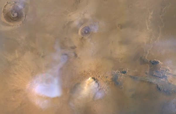
By combining observations from three international spacecraft at Mars, scientists were able to show that regional dust storms play a huge role in drying out the Red Planet.
Dust storms heat up higher altitudes of the cold Martian atmosphere, preventing water vapor from freezing as usual and allowing it to reach farther up.
In the higher reaches of Mars, where the atmosphere is sparse, water molecules are left vulnerable to ultraviolet radiation, which breaks them up into their lighter components of hydrogen and oxygen.
Hydrogen, which is the lightest element, is easily lost to space, with oxygen either escaping or settling back to the surface.
“All you have to do to lose water permanently is to lose one hydrogen atom because then the hydrogen and oxygen can’t recombine into water,” said Michael S. Chaffin, a researcher at the Laboratory for Atmospheric and Space Physics at the University of Colorado at Boulder. “So when you’ve lost a hydrogen atom, you’ve definitely lost a water molecule.”
Scientists have long suspected that Mars, once warm and wet like Earth, has lost most of its water largely through this process, but they didn’t realize the significant impact of regional dust storms, which happen nearly every summer in the planet’s southern hemisphere.
Globe-enveloping dust storms that strike typically every three to four Martian years were thought to be the main culprits, along with the hot summer months in the southern hemisphere when Mars is closer to the Sun.
But the Martian atmosphere also gets heated during smaller, regional dust storms, according to a new paper published August 16 in the journal Nature Astronomy. The researchers, an international team led by Chaffin, found that Mars loses double the amount of water during a regional storm as it does during a southern summer season without regional storms.
“This paper helps us virtually go back in time and say, ‘OK, now we have another way to lose water that will help us relate this little water we have on Mars today with the humongous amount of water we had in the past,” said Geronimo Villanueva, a Martian water expert at NASA’s Goddard Space Flight Center in Greenbelt, Maryland, and co-author on Chaffin’s paper.
Since water is one of the key ingredients for life as we know it, scientists are trying to understand how long it flowed on Mars and how it was lost.
Billions of years ago, Mars had vastly more water than it does today. What’s left is frozen at the poles or locked in the crust. Melted, this leftover water could fill a global ocean up to 100 feet, or 30 meters, deep, some scientists predict.
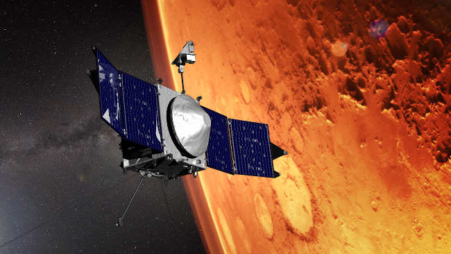
Although scientists like Chaffin had many ideas about what was happening to the water on Mars, they lacked the measurements needed to tie the whole picture together. Then, a rare convergence of spacecraft orbits during a regional dust storm in January through February 2019 allowed scientists to collect unprecedented observations.
NASA's Mars Reconnaissance Orbiter measured the temperature, dust and water-ice concentrations from the surface to about 62 miles above it.
Looking within the same altitude range, the European Space Agency’s Trace Gas Orbiter measured the concentration of water vapor and ice. And NASA’s Mars Atmosphere and Volatile EvolutioN, or MAVEN, spacecraft capped off the measurements by reporting the amount of hydrogen, which would have broken off H2O molecules, in the highest reaches of Mars, upwards of 620 miles, or 1,000 kilometers, above the surface.
It was the first time so many missions focused in on a single event, Chaffin said: “We’ve really caught the whole system in action.”
The data collected from four instruments on the three spacecraft paint a clear picture of a regional dust storm’s role in Martian water escape, scientists report. “The instruments should all tell the same story, and they do,” said Villanueva, a member of the Trace Gas Orbiter’s science team.
Spectrometers on the European orbiter detected water vapor in the lower atmosphere before the dust storm began.
Typically, the temperature of the Martian atmosphere gets colder with height for much of the Martian year, which means water vapor rising in the atmosphere freezes at relatively low altitudes.
But as the dust storm took off, heating the atmosphere higher up, the instruments saw water vapor reaching higher altitudes. These instruments found 10 times more water in the middle atmosphere after the dust storm started, which coincides precisely with data from the infrared radiometer on the Mars Reconnaissance Orbiter.
The radiometer measured rising temperatures in the atmosphere as dust was raised high above Mars. It also saw water-ice clouds disappear, as expected, since ice could no longer form in the warmer lower atmosphere.
Images from MAVEN’s ultraviolet spectrograph confirm this; they show that before the 2019 storm, ice clouds could be seen hovering above the soaring volcanoes in the Tharsis region of Mars. “But they disappeared completely when the dust storm was in full swing,” Chaffin said, and reappeared after the dust storm ended.
At higher altitudes, water vapor is expected to break down into hydrogen and oxygen by the Sun’s ultraviolet radiation. Indeed, observations from MAVEN showed this, as it captured the upper atmosphere aglow with hydrogen that increased by 50% during the storm.
This measurement corresponded perfectly with a swelling of water 60 miles below, which scientists say was the source of the hydrogen.
This research was funded in part by the MAVEN mission. MAVEN's principal investigator is based at the University of Colorado Boulder's Laboratory for Atmospheric and Space Physics, and NASA Goddard manages the MAVEN project. The Mars Reconnaissance Orbiter, which also funded some of this research, is managed by Jet Propulsion Laboratory, California Institute of Technology, for NASA.
Lonnie Shekhtman works for NASA's Goddard Space Flight Center in Greenbelt, Maryland.