SACRAMENTO – Standing 10 feet below street level, the city of Sacramento takes on a completely new dimension.
Above you the faint murmur and echoes of thousands of tourists fall through the chinks in the wood boardwalk, filter through the earth and emerge between cracks in the century-and-a-half old brick that keeps all the above – people and earth and brick – from crashing down on you.
Sheriff George “Tight Knot” Lee did promise to take me behind, or rather under, the scenes of Old Sacramento. He certainly didn’t disappoint.
Old Sacramento, a state historic park, sees millions of tourists each year. Between the restaurants, candy shops and museums, there’s certainly a lot to see.
After a while, though, local residents get burned out on the same ol’ same ol’ and soon Old Sacramento just becomes somewhere you take out of town relatives to when you get tired of entertaining them yourself.
The staff of the SHM’s “It’s Jacked Up!” tour intend to turn that notion upside down – literally.
With the amiable Sheriff Lee – whose real name is Steve Bralley, a local businessman/volunteer tour guide now outfitted in a historic costume – our group sets out from the museum and strolls across the green lawn to first row of squat brick buildings.
Stopping abruptly at the mouth of an alleyway, Sheriff Lee turns on his spurred heels and faces our group.
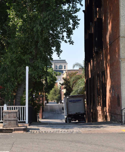
Behind the sheriff, the broad alleyway slopes down out of sight. A block away, the cobbled path reappears as it rises to the level of the next street before once more falling from view and reappearing another block away. Looking down the length of it, Firehouse Alley looks like a long rope strung loosely from L, K and J Streets.
His back to the alleyway, Sheriff Lee now says in a slight southern drawl, “The early settlers here, having built a home for themselves and invested capital in making this place a reality, were intent on staying here – even though “here” was a terrible place to build a city.”
Gesturing for us to follow him, the sheriff turns around and descends the gentle slope of Firehouse Alley. Once at the floor of the pathway – about 10 to 15 feet below the level of the street – we turn to the left and approach the back of the B.F. Hastings building, walking towards a black iron door.
With one hand on the door, Sheriff Lee begins again: “Where we’re now standing was the original level of Old Sacramento.”
The sheriff proceeds to explain to us that before the discovery of gold made the area a household name, the central valley of California was sparsely populated. Those who did dwell among the oak groves and tulle-skirted rivers understood that their existence rested on an uncertain foundation.
The low-lying land of the river valley perennially flooded. During particularly wet winters, you could stand on the foothills of the coastal range, look east to the foothills of the Sierra Nevada, and see oak groves rising from a muddy morass of floodwaters.
Stretching from rim to rim would arise an inland sea, with the occasional knoll of high land peeking out as an island and refuge for the Native Americans and Californio ranchers.
It was right here in the marshy meadows that the new Euro-American immigrants chose to build their city. Within a few years, residents realized their mistake as flood after flood washed away their homes. Their stubborn determination to rebuild after each fresh disaster led one Nevada journalist to quip that Sacramento suffered a certain “dementia.”
If they were crazy, there was at least a method to their madness that time itself soon revealed. Eventually tiring of the flooding, these early Sacramentans devised a means to cheat nature and rise above the floodwaters one brick foot at a time.
“You see, with the levees they built barely helping at all, these stubborn, entrepreneurial people decided the best thing they could do was raise the level of the buildings,” with that Sheriff Lee pushes open the heavy iron door.
Gesturing for us to enter, he follows us as we all walk out of the summer sun and into the dim interior.
“Sacramento is just one of three cities in the United States that raised its buildings and street levels. The other two were Seattle and Chicago.” Rather than echoing in the rather spacious basement we now stand in, Sheriff Lee’s voice seems to absorb into the soft brick walls and archways that disappear into the darkness.
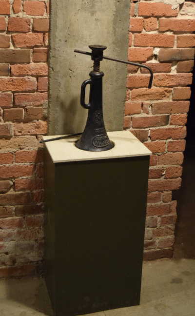
A railroad jack on display at Old Sacramento, Calif. Photo by Antone Pierucci.
Actually, we aren’t in a basement at all, as we soon learn to our amazement. Or rather, it is now, but it wasn’t always so. In fact, we are standing in what was, for the first decade or more of its life, the street level of the B.F. Hastings building.
This, then, is the level where the Pony Express riders dropped their satchels full of letters from back east; where the State Supreme Court justices entered when they came to conduct their business in the courtroom on the second floor; where took place the rip-roaring good times of a Gold Rush town flush with too much fast cash and all the creature comforts it could buy.
“When the town leaders decided to raise the level of the streets in 1864, business owners had two choices,” Sheriff Lee explains to our group. “They could jack up their buildings to the new street level and build a basement or they could lose their first floor (which would then become their new basement and their second floor their new first). Benjamin Franklin Hastings of the B.F. Hastings building decided to jack his up.”
The process of raising tons of brick, wood and wrought iron wasn’t as complicated as you would think. All it took was manpower, long wood beams and railroad jacks.
The first step in the process required digging a number of tunnels running lengthwise and widthwise under the building. Tall enough for a man to crouch, each tunnel then had a long timber inserted through it like a thread through the eye of a needle.
Where the timbers crossed each other, a jack was placed. Back into the tunnels crawled the workers and with the cry of a whistle, each man twisted the jackscrew one full revolution. Another whistle call, another crank and so on inch by inch.
Sheriff Lee explains the mechanics of raising the building we now find ourselves under with the aid of a model. A scaled-down Hastings building sits on a tabletop, four small railroad jacks under each corner of the building. Our guide asks for volunteers and I take my place on one corner.
“Please turn the screw eight times and then step back,” he instructs. After some cranking, the model building groans and squeaks upwards with each twist of the screw. At the end, we step back and I peer over the dangerously-slanted building to an amused Sheriff Lee. The roofline slants downwards towards my corner, a clear indictment of my work.
Pointing to me, he says, “You probably wouldn’t last long on the jack line.” Thankfully, my mistake creates an opening for Sheriff Lee to explain the work a bit more.
“They used buckets of water on the roof as a level to make sure mistakes like this [pointing at my sad slope] were corrected. Once they had jacked the building up, they constructed wood cribs underneath and proceeded to build brick piers and arches for support. Along the perimeter of each building they also had to build a retaining wall of brick with buttresses to support the tons of dirt that was going to be filling in to raise the level of the streets.”
Over the next 13 years, close to 1,000 buildings were raised in this manner in Old Sacramento. The cost of raising each building was borne by the owner of the building, which is why some businessmen decided to simply lose their first floor to the rising street level rather than pay the cost of saving it.
At the end of the affair, when asked if they wanted to help pay for raising the level of the alleyways, the building owners answered with a resounding “no way!” That’s why to this day Firehouse Alley looks like an exhausted elastic band, running along the width of Old Sacramento in a bunched line of rolling slopes.
As we finish our exploration of the underground space, Sheriff Lee guides us towards the black iron door we first entered. Emerging from the underbelly of the building, it takes some time for our eyes to readjust to the rising mid-morning sun peaking over the crenellation of the Hastings building.
“If you will follow me,” the businessman-cum-living-history-actor beckons, “our next stop will take us to the foundations of some of the earliest buildings in Sacramento’s history, to a glimpse of the seedier side of this riverside gold rush town.”
Walking back up to the level of the modern street, passing tourists stare questioningly at our troupe. I can’t help but smile as we walk past them on to our next historical spelunking adventure.
Some people can’t imagine what mysteries lie hidden beneath their feet.
If you go
The underground tour is offered on the weekends year-round. Between the Memorial Day weekend and Labor Day weekend, however, the SHM runs it 7 days a week, several times a day. For times and availability (and to book a spot on the tour) visit http://sachistorymuseum.org/tours/underground-tours/. It only costs $15 for adults and $10 for youths age 6 to 17. Children 5 and under are free; however, the SHM does not recommend the tour for this age group.
The museum offers a more adult-focused tour that runs Thursday through Saturday starting at 6 P.M. According to Shawn Turner, manager of tour programs, “the after-hours tour explores more those first 10 years of Sacramento’s history and so touches on topics of houses of ill-repute and gambling halls and those sorts of things that happened at night.”
Both tours are ADA-accessible.
Antone Pierucci is a Sacramento-based public historian and a freelance writer whose work has been featured in such magazines as Archaeology and Wild West as well as regional California newspapers.
CORRECTION: An earlier version of this story incorrectly reported a different number of buildings raised in the city during a 13-year period. The correct amount is close to 1,000.
Firehouse Alley in Old Sacramento, Calif. Photo by Antone Pierucci.
This week in history takes a look at Lady Liberty, unmasking the people and events that led to her creation.
Aug. 5, 1884
It was a muggy August day in 1884 when a crowd of politicians, newsmen and Freemasons gathered on the naked stretch of land atop Bedloe’s Island.
Bedloe’s Island or Oyster Island or Love’s Island, the name of this small barnacle of dry soil in New York harbor changed with its ownership. Over the centuries the island had been a refuge for Tories during the Revolution, a country villa for the wealthy, a hospital and, most enduring, a military fort.
On this day in history, the men gathered on the island were preparing to change its name once more.
The usual interminable speeches were given, the proud pronouncements of congratulations and thanks that accompany any and all formal events.
Finally, the moment arrived and William A. Brodie, the Grand Master of New York’s Free and Accepted Masons, intoned solemn words over the cornerstone of what would soon be the base of the Statue of Liberty.
It was a grand scene – despite the thick air of a New York Summer – and one that proved a fitting conclusion to a journey that had begun decades earlier in a dining room in Paris.
The inception
In the summer of 1865, a group of men sat around a table in the suburbs of the City of Lights, discussing the politics of the day. In attendance was a somewhat hodgepodge collection of characters: Edouard Rene de Laboulaye, the owner of the house and a well-known author; noted historian Henri Martin; Oscar and Edmond de Lafayette, grandsons of the Marquis de Lafayette of American Revolution fame; and a young artist from the Alsace region, Frederic Auguste Bartholdi.
It was reportedly Laboulaye who first off-handedly remarked how wonderful it would be for France to present the American people with a monument to memorialize the friendship between the two nations, two sister republics and bastions of freedom.
Although no action would be taken for some years, the idea of a monument germinated in the creative mind of the young artist Bartholdi, where it found fertile ground.
Following the 1870 revolution that overthrew the Louis-Napoleon monarchy and the disastrous conclusion to the Franco-Prussian War, the time seemed ripe for France to reconnect with America.
In 1871, the plan for the as-yet-unnamed monument was rejuvenated, with Laboulaye garnering support for the project at home and Bartholdi raising interest in America.
It was decided that America would finance the construction of the pedestal and France that of the statue itself. The plan was to erect the monument by July 4, 1876 – the centennial anniversary of the signing of the Declaration of Independence.
The iconic monument took form as a resolute lady liberty. In one hand she held a tablet bearing the date of July 4, 1776; in the other, a blazing torch of enlightenment. The statue’s symbolism, as well as its actual name, "Liberty Enlightening the World," reflected the emotions behind her formation.
To the values of liberty, freedom and knowledge would Lady Liberty stand at the entrance to America, proclaiming their superiority over all others. Her very genealogy would be a testament to the deep kinship between France and America.
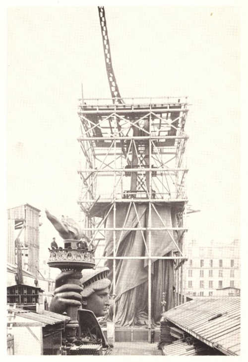
The construction of the Statue of Liberty. Public domain image.
The reality
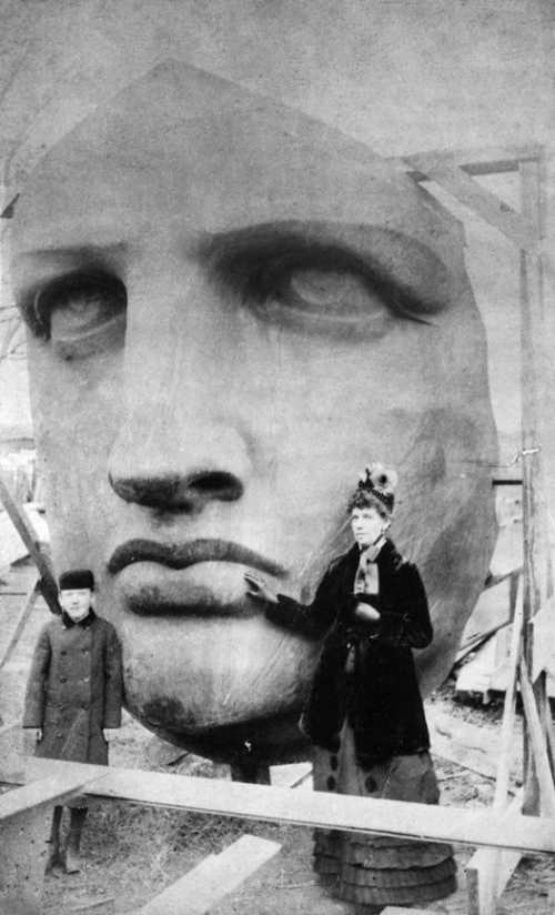
Despite raising a significant amount of money for both the pedestal and the actual statue, Lady Liberty arose from the heaps of bronze, copper and iron only incrementally.
Rather than unveiling her in all her glory on July 4, 1876, Bartholdi and his compatriots could only show her extended arm, clutching the torch. They built the rest of Lady Liberty over the next eight years.
When the French finally finished their part of the bargain in 1884, they looked to the Americans to uphold theirs.
With the ceremonial cornerstone laying on Aug. 5, 1884, construction of the pedestal began in earnest. It still took two years to complete.
In that time, Lady Liberty had been disassembled, packed aboard a French ship and unloaded in New York, only to wait while workers finished construction of her pedestal.
Rather than a hindrance to the project, the old star-shaped Fort Wood that had sat on the island for almost a century had been incorporated into Liberty’s base.
Finally, in 1886 all was ready for assembling her in her final place. The work proceeded rapidly and by October 28, 1886—just 10 years and three months late—Bartholdi himself drew back the French flag covering Liberty’s face to the sounds of whistles, the roar of guns and the applause of those below.
The Statue of Liberty, as the striking monument was popularly nicknamed, stood 151 feet tall.
Although first envisioned as a monument to democracy and enlightenment, the symbolism of the statue evolved with the nation.
When, in 1903, officials placed a bronze plaque bearing Emma Lazarus’ now-famous poem, "The New Colossus," Liberty became an emblem of America’s promise to the world’s poor. With her austere gaze, she commanded the entry into the port of New York.
She still stands there today, a testament to the value of freedom so greatly cherished by the democracies that birthed her. "Give me your tired, your poor; Your huddled masses yearning to breathe free… I lift my lamp beside the golden door!"
Antone Pierucci is a Sacramento-based public historian and a freelance writer whose work has been featured in such magazines as Archaeology and Wild West as well as regional California newspapers.
The Statue of Liberty, before it was assembled. Public domain image.
LOWER LAKE, Calif. – The Lake County Weed Management Area recently hosted its 14th annual "Invasive Weeds Tour" at Anderson Marsh State Historic Park.
Since July is "California Invasive Weed Awareness Month" an interesting and energetic collection of participants and presenters were present.
The weed walk was sponsored by the Lake County Department of Agriculture and the Lake County Resource Conservation District, or LCRCD, with Charlotte Griswold, president of LCRCD on hand.
This walk was encouraged to educate the public about the increasing amount of non-native invasive weeds that proliferate in our parks, yards and landscapes, and the results of this influx.
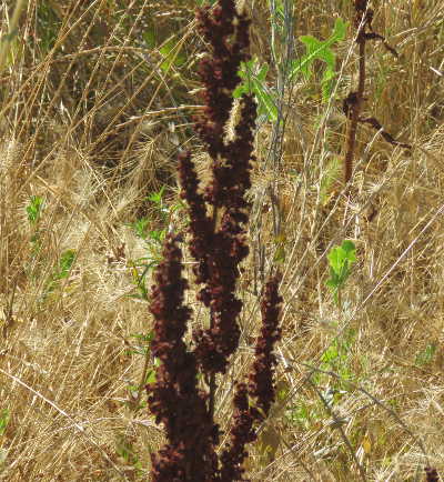
Curly dock, a non-native plant. Photo by Kathleen Scavone. After the walk a lunch was provided in the shade of the ancient oaks near the Anderson Ranch House. The event then culminated in a discussion of aquatic invasive plants – another important topic for our diverse county to consider.
Some of the experts who led and discussed the central topics included Trish Ladd, environmental scientist from the California Department of Parks and Recreation, Bill Lincoln of LCRCD, Victoria Brandon who works with the Lake County Land Trust and Sierra Club, Catherine Vanderwall of the California Department of Food and Agriculture, McLaughlin Natural Reserve Director Paul Aigner and Anderson March Interpretive Association Board Member Henry Bornstein. Also in attendance were some of the group from the Lake County Master Gardeners.
Identified on the walk, some of the many invasive plants that are taking over the grasslands at Anderson Marsh State Historic Park and other California regions are curly dock, some kinds of morning glories, Italian rye grass, Himalayan blackberry, vetch, and many more European and Asian grasses.
A familiar invasive plant is the star thistle, a noxious weed that probably arrived in the Bay Area during the Gold Rush era. It originated in Turkey or Greece.
The release of a particular type of weevil, along with control burns and herbicides in some areas, have somewhat reduced the onslaught of starthistle plants.
Lake County enjoys a temperate climate which is conducive to the growth of a variety of plant life. This is true of most of California.
Because of its temperate climate there are around 6,300 native plant species in our state. Both native plants and non-native plants, or invasives thrive, due in part to this temperate climate, but our landscapes and creeks can become ruined by exotic plants who take up nutrients and water in the soil that were intended for the natives. Invasive plants may add fuel for fires, as well.
Once the invasive plants take hold they are also prone to change the habitat and leave the plants and animals who once lived in a niche high and dry.
Although the change to the landscape is small, each minute alteration in the biodiversity breaks an important link in the chain that is important to the environment.
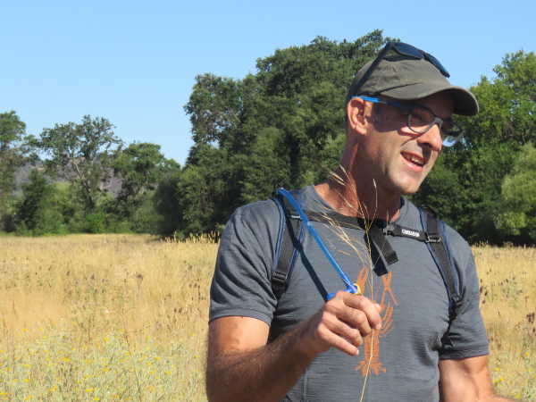
McLaughlin Natural Reserve Director Paul Aigner holds the non-native ripgut broom grass during the annual invasive weed tour at Anderson Marsh state Historic Park in Lower Lake, Calif., on Thursday, July 20, 2017. Photo by Kathleen Scavone. Where do these unwanted plants come from that are crowding out and threatening the landscape?
They sometimes arrive via our gardens or aquariums, sometimes escaping and growing where they are unwanted. They hitchhike on clothing, vehicles or animals, and sometimes through agricultural feed and seed.
The goal is to restore grasslands to the conditions prior to European arrival, and to promote native plants.
With the serpentine soils found in Lake County a refuge of sorts is found to enhance the native grasses, because non-natives do not thrive as well on the serpentine soils.
Where the soil has been intensively disturbed due to farming or other means, the invasive plants begin to take hold, even blotting out the state grass, purple needle.
Various methods to deter non-native plants have included herbicides and professional prescribed burns.
Afterwards native grasses can be planted, including perennial and annual plants for stability to deter re-invasion.
On a smaller scale, hand-pulling or even solarization – when the young plant is covered, thereby “smothering” it before it takes hold, are often effective deterrents to invasive plants.
Kathleen Scavone, M.A., is a retired educator, potter, writer and author of “Anderson Marsh State Historic Park: A Walking History, Prehistory, Flora, and Fauna Tour of a California State Park” and “Native Americans of Lake County.” She also formerly wrote for NASA and JPL as one of their “Solar System Ambassadors.” She was selected “Lake County Teacher of the Year, 1998-99” by the Lake County Office of Education, and chosen as one of 10 state finalists the same year by the California Department of Education.
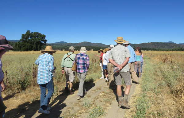
A group hikes on the grasslands at Anderson Marsh State Historic Park in Lower Lake, Calif., on Thursday, July 20, 2017. Photo by Kathleen Scavone.
NASA scientists have definitively detected the chemical acrylonitrile in the atmosphere of Saturn’s moon Titan, a place that has long intrigued scientists investigating the chemical precursors of life.
On Earth, acrylonitrile, also known as vinyl cyanide, is useful in the manufacture of plastics. Under the harsh conditions of Saturn’s largest moon, this chemical is thought to be capable of forming stable, flexible structures similar to cell membranes.
Other researchers have previously suggested that acrylonitrile is an ingredient of Titan’s atmosphere, but they did not report an unambiguous detection of the chemical in the smorgasbord of organic, or carbon-rich, molecules found there.
Now, NASA researchers have identified the chemical fingerprint of acrylonitrile in Titan data collected by the Atacama Large Millimeter/submillimeter Array, or ALMA, in Chile.
The team found large quantities of the chemical on Titan, most likely in the stratosphere – the hazy part of the atmosphere that gives this moon its brownish-orange color.
“We found convincing evidence that acrylonitrile is present in Titan’s atmosphere, and we think a significant supply of this raw material reaches the surface,” said Maureen Palmer, a researcher with the Goddard Center for Astrobiology at NASA’s Goddard Space Flight Center in Greenbelt, Maryland, and lead author of a July 28 paper in Science Advances.
The cells of Earth’s plants and animals would not hold up well on Titan, where surface temperatures average minus 290 degrees Fahrenheit (minus 179 degrees Celsius), and lakes brim with liquid methane.
In 2015, university scientists tackled the question of whether any organic molecules likely to be on Titan could, under such inhospitable conditions, form structures similar to the lipid bilayers of living cells on Earth.
Thin and flexible, the lipid bilayer is the main component of the cell membrane, which separates the inside of a cell from the outside world. This team identified acrylonitrile as the best candidate.
Those researchers proposed that acrylonitrile molecules could come together as a sheet of material similar to a cell membrane. The sheet could form a hollow, microscopic sphere that they dubbed an “azotosome.” This sphere could serve as a tiny storage and transport container, much like the spheres that lipid bilayers can form.
“The ability to form a stable membrane to separate the internal environment from the external one is important because it provides a means to contain chemicals long enough to allow them to interact,” said Michael Mumma, director of the Goddard Center for Astrobiology, which is funded by the NASA Astrobiology Institute. “If membrane-like structures could be formed by vinyl cyanide, it would be an important step on the pathway to life on Saturn’s moon Titan.”
The Goddard team determined that acrylonitrile is plentiful in Titan’s atmosphere, present at concentrations up to 2.8 parts per billion. The chemical is probably most abundant in the stratosphere, at altitudes of at least 125 miles (200 kilometers). Eventually, acrylonitrile makes its way to the cold lower atmosphere, where it condenses and rains out onto the surface.
The researchers calculated how much material could be deposited in Ligeia Mare, Titan’s second-largest lake, which occupies roughly the same surface area as Earth’s Lake Huron and Lake Michigan together.
Over the lifetime of Titan, the team estimated, Ligeia Mare could have accumulated enough acrylonitrile to form about 10 million azotosomes in every milliliter, or quarter-teaspoon, of liquid. That’s compared to roughly a million bacteria per milliliter of coastal ocean water on Earth.
The key to detecting Titan’s acrylonitrile was to combine 11 high-resolution data sets from ALMA. The team retrieved them from an archive of observations originally intended to calibrate the amount of light being received by the telescope array.
In the combined data set, Palmer and her colleagues identified three spectral lines that match the acrylonitrile fingerprint. This finding comes a decade after other researchers inferred the presence of acrylonitrile from observations made by the mass spectrometer on NASA’s Cassini spacecraft.
“The detection of this elusive, astrobiologically relevant chemical is exciting for scientists who are eager to determine if life could develop on icy worlds such as Titan,” said Goddard scientist Martin Cordiner, senior author on the paper. “This finding adds an important piece to our understanding of the chemical complexity of the solar system.”
ALMA, an international astronomy facility, is a partnership of the European Organisation for Astronomical Research in the Southern Hemisphere, the U.S. National Science Foundation and the National Institutes of Natural Sciences of Japan in cooperation with the Republic of Chile.
Elizabeth Zubritsky works for NASA’s Goddard Space Flight Center in Greenbelt, Maryland.
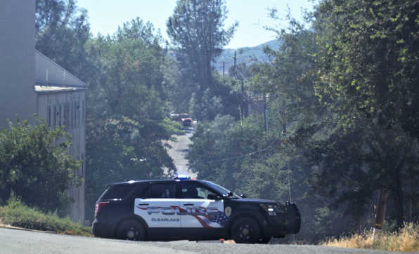
CLEARLAKE, Calif. – Two structures were burned in a Friday afternoon fire that briefly prompted evacuations in a part of Clearlake.
The fire in the area of Snook and Davis avenues was first reported at about 3 p.m., and drew a response from Lake County Fire and Cal Fire, as well as fire agencies around Lake County, which sent resources as part of an in-county strike team.
For two and a half hours the Clearlake Police Department had the area of Davis and West 40th – behind Foods, Etc. and Westamerica Bank – due to the fire.
Evacuations were briefly in place for homes in the area as well, with a medical clinic on nearby Lakeshore Drive evacuating on precaution, according to radio reports.
About 45 minutes after dispatch, incident command reported that forward progress was stopped.
Lake County Fire Battalion Chief Charlie Diener said a total of two structures were burned.
He said the structure of origin was an abandoned red-tagged home where it was believed transients were living.
Diener said the fire also burned a home next to the red-tagged structure.
“We don’t know if it was occupied or not,” he said of the second structure on Friday evening.
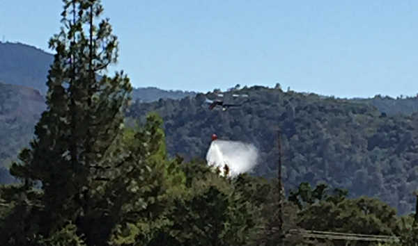
A Cal Fire helicopter drops water on a fire in Clearlake, Calif., on Friday, July 28, 2017. Photo by Gordon Eisler. The structure where the fire originated had no power supply, Diener said.
Diener said they didn’t yet have an idea of the cause, but noted, “It’s suspicious in nature.”
In addition to the structures, Diener estimated between three and five acres of vegetation burned.
By early evening, all evacuations had been called off, Diener said.
Diener and the last units cleared the scene shortly after 7:15 p.m., following several hours of mop up and overhaul.
He said no injuries were reported.
The Clearlake fire came less than 24 hours after a barbecue sparked a fire that threatened a Lucerne neighborhood.
The Foothill fire in Lucerne destroyed two homes and damaged a third, with three outbuildings, two cars and three and a half acres of vegetation also burned, as Lake County News has reported.
Email Elizabeth Larson at This email address is being protected from spambots. You need JavaScript enabled to view it. . Follow her on Twitter, @ERLarson, or Lake County News, @LakeCoNews.
The Clearlake Police Department closed off the area of Davis and West 40th in Clearlake, Calif., on Friday, July 28, 2017, due to a fire that burned structures and wildland. Photo by Sue Flint.
NORTHERN CALIFORNIA – The American Bittern’s “pumper-lunk” call has got to be one of the strangest sounds I have ever heard.
When I first heard it, I thought the sound was coming from some kind of oddball frog, but when I realized the sound was coming out of a bird, I was truly astonished.
Their calls, sometimes also referred to as “booming,” have given rise to the bird’s nicknames like “thunder pumper” and “water belcher.”
The call starts with the clapping of the bittern’s bill. As it claps, the bird draws air into its esophagus and holds it there.
Once the esophagus is sufficiently inflated, the bittern forces the air out past its syrinx (voice box) while pressing its head down and out. Think of it as something like a “melodious burp.”
You can see and hear a sample of the call in the video on this page, which was taken in April at the Sacramento National Wildlife Refuge in Glenn County, along the auto-tour route.
The call is used by males to establish their territory and attract females. They can hear challengers’ calls from more than 1,000 feet away, and respond by more booming, standing tall, and rushing out in a crouched position to meet challengers head on.
The American Bittern generally lives in freshwater marshes. The species’ numbers have been declining over the past several years, some say by as much as 43 percent, due to wetland degradation and habitat loss. Photo by Mary K. Hanson. Usually, the battles between the males are relatively mild, consisting of more booming and posturing, but when the fights escalate, they can be brutal.
Male bitterns are known to fly up into the air and stab at each other with their sharp beaks until one of them leaves the disputed territory or simply cannot fight anymore.
Except for the breeding season when mating pairs come together, the bitterns live solitary lives in freshwater wetland areas that have high vegetation, like tules.
Camouflaged well by their brown and white bodies, they often stand stock still with their head held high, beak pointing skyward, so that the long brown streaks down their neck blend in with the shadows between the cattails and tules. It’s along the fringes of high vegetation where you’ll most likely see them, and usually in the early morning or dusk hours.
The bitterns’ eyes are yellow (except in the breeding season when they turn orange) and are able to cant downward, unlike most other birds whose eyes are fixed in their sockets and don’t move much.
This gives the bittern an advantage over some other marshland birds in seeking and finding prey. It’s also believed to rock its head back and forth when it’s hunting, so the eyes can see past the surface glare of the water into the depth below.
Like herons and egrets, bitterns hunt in and around shallow water with a stab-and-grab technique. They stand still, watching for prey, and then jab at with their bill when it comes close enough. Once caught the prey is either stabbed, crushed or shaken to death and then swallowed whole.
Bitterns have a varied diet that includes insects, crustaceans (crayfish are a favorite), fish, frogs and tadpoles, salamanders, snakes and small mammals like voles. What they can’t digest they vomit out later in pellet form (rather like owls do).
Bitterns stand with their neck stretched and their bill pointing to the sky in order to blend in with the shadow patterns around them. In this photo you can see how the bird is able to cant its eyes downward, so even while the head is up, it can still see what is in front of it. Photo by Mary K. Hanson. Between their fighting, belching, and vomiting male bitterns may not seem like much of a catch … and the fact that they only need about 15 seconds to mate may not impress ladies all that much, either.
But remember that these are generally solitary birds to begin with. The males depart as soon as the mating is over, and the female sets out on her own to lay her eggs and tend to her brood.
The female will pick out a spot among the cattails, sedges and tules that it can flatten out into a mound and then line with grass. Usually the mounds are around 15 inches in diameter, but they can be smaller.
She’ll lay a clutch of up to about seven eggs (that will be olive or beige-brown) and incubate them for about four weeks.
When the chicks hatch, they’re covered in pinkish-yellow down and sport a pink bill and large eyes (which like their parents’ can cant downward making them look cross-eyed a lot).
As soon as they’re able to lift their heads, they’re doing the bittern neck-stretch, pointing their bills at the sky, trying to blend into their surroundings.
They’re able to leave the nest in about two weeks, and fledge in about six weeks. By then they’re on their own: females looking for mates and nesting sites of their own, and males belching out their “pumper-lunk” calls to establish their territories.
Next time you’re out near a wetland area, listen for the American Bitterns. Their call is unmistakable and unforgettable.
Mary K. Hanson is a Certified California Naturalist, author and nature photographer. She will be co-teaching a naturalist course for the public through Tuleyome in early 2018. Tuleyome is a501(c)(3) nonprofit conservation organization based in Woodland, Calif. For more information, visit www.tuleyome.org.
 How to resolve AdBlock issue?