 How to resolve AdBlock issue?
News
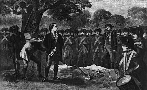
By all accounts, it was a moving speech.
Frederick MacKensie, a British officer who witnessed it, wrote in his diary, "he behaved with great composure and resolution, saying he thought it the duty of every good Officer, to obey any orders given him by his Commander-in-Chief; and desired the Spectators to be at all times prepared to meet death in whatever shape it might appear.”
The “Essex Journal” reported, "he made a sensible and spirited speech." No one has been able to flesh out the complete contents of Nathan Hale’s final speech before being hanged a spy, but several bits were recorded and have since been etched into our national consciousness.
The “Essex Journal” reported Hale as saying, "if I had ten thousand lives, I would lay them all down in defense of this injured, bleeding country." But by far the most oft-quoted line Hale spoke that day at the gallows was reported by “The Independent Chronicle and the Universal Advertiser.”
According to this newspaper, Hale remarked, "I am so satisfied with the cause in which I have engaged, that my only regret is that I have not more lives than one to offer in its service."
* * *
He is remembered more as a martyr than a spy. In fact, his espionage career lasted only a few weeks, but when Nathan Hale was hanged on Sept. 22, 1776, it sent shockwaves through the embattled colonies, affecting the hearts and minds of Americans far more than any act of espionage could.
The war, such as it was, had only just commenced and the execution of an unarmed combatant robbed the patriots of any remaining illusions that what was about to follow would be anything but brutal. War is hell, and in hell anything goes – the execution of a spy was a matter of course.
Nathan Hale came from a generally-well-to-do family in Connecticut. At 18 years old, he graduated from Yale University and began teaching school upon graduation.
When the first shots of the Revolutionary War rang out in the Connecticut countryside, Hale’s five brothers were in the thick of it, fighting the British at Lexington and Concord.
Eager to make his mark in the nascent revolution, Nathan Hale joined the Continental Army as a first lieutenant. In a matter of months, he was promoted to captain.
The early years of the revolution went poorly for the Americans, with the British evacuating Boston only to show up and invade New York City.
Washington’s humiliating retreat from the city cast a pallor over the country and seemingly confirmed the British belief that the rebellion would soon be over.
It was during these dark times that Capt. Nathan Hale volunteered to cross behind enemy lines and serve his country in what at the time was considered a somewhat dishonorable position: he would be a spy.
As any spook worth his salt will tell you, all good lies contain an element of truth. For Capt. Hale, this meant posing as a Dutch schoolteacher. For a while, his ruse worked, and the captain gathered information on enemy troop numbers and movement.
However, Hale was not trained for spying and he appears to have made some mistakes. Here the story of Nathan Hale slips in and out of legend.
One account says that a cousin of his, who was a loyalist, recognized him and turned him into the British authorities.
Another version paints Hale in a slightly more naïve light. In this version, British Major Robert Rogers encountered the disguised Hale and smelled something fishy. Getting Hale to trust him by saying he himself was a spy for the Americans, Rogers appears to have tricked Capt. Hale into letting on about his mission.
Regardless of the cause, we know that Capt. Hale was captured and interrogated sometime around Sept. 20 or 21 – the very day or shortly after a large portion of New York City was set alight by suspected American spies.
The burning of their winter quarters set the British on edge and orders were soon issued for the execution of the only spy they had in custody: Nathan Hale.
It is fair to say that Nathan Hale was not a very good spy. It is also fair to say that by all accounts, this 21 year old was a brave and patriotic young man who faced death with the type of stoic composure reserved for legends.
It is this quality, and the fact that he was the first American spy to die in service to his country, that a statue of Nathan Hale stands outside the headquarters of the Central Intelligence Agency in McLean, Virginia.
Antone Pierucci is curator of history at the Riverside County Park and Open Space District and a freelance writer whose work has been featured in such magazines as Archaeology and Wild West as well as regional California newspapers.
NORTHERN CALIFORNIA – A fire that began last weekend in Napa County has been fully contained.
Cal Fire said the Snell fire was 100-percent contained at 2,490 acres as of Saturday evening.
The fire began Sept. 8 southeast of Middletown near the Berryessa Estates subdivision, triggering mandatory evacuations and road closures in the area.
Ultimately, no structures were damaged or destroyed, Cal Fire said.
Officials said five engines and 27 personnel remain assigned to the incident, and were set to continue patrolling overnight to look for any remaining hot spots.
Cal Fire said the cause of the fire remains under investigation.
Email Elizabeth Larson atThis email address is being protected from spambots. You need JavaScript enabled to view it. . Follow her on Twitter, @ERLarson, or Lake County News, @LakeCoNews.
Cal Fire said the Snell fire was 100-percent contained at 2,490 acres as of Saturday evening.
The fire began Sept. 8 southeast of Middletown near the Berryessa Estates subdivision, triggering mandatory evacuations and road closures in the area.
Ultimately, no structures were damaged or destroyed, Cal Fire said.
Officials said five engines and 27 personnel remain assigned to the incident, and were set to continue patrolling overnight to look for any remaining hot spots.
Cal Fire said the cause of the fire remains under investigation.
Email Elizabeth Larson at
When an El Niño or its opposite, La Niña, forms in the future, it's likely to cause more intense impacts over many land regions – amplifying changes to temperature, precipitation, and wildfire risk – due to the warming climate.
These are the findings of a new study led by the National Center for Atmospheric Research, or NCAR, and published in Geophysical Research Letters, a journal of the American Geophysical Union.
The researchers found, for example, that the increased wildfire danger in the southwestern United States associated with La Niña events would become more acute.
Conversely, the cooler and wetter weather in the same region associated with El Niño events would likely become even cooler and even wetter in the future, enhancing associated flood risks.
"The cycling between El Niño and La Niña is responsible for some of the weather whiplash we get from year to year, particularly in the western U.S.," said NCAR scientist John Fasullo, who led the study. "What we find when we look at model simulations of the future is that the whiplash is likely to get more severe."
The study was funded by the National Science Foundation, which is NCAR's sponsor, and by the U.S. Department of Energy. Study coauthors are Bette Otto-Bliesner, also of NCAR, and Samantha Stevenson, of the University of California, Santa Barbara.
Far-reaching consequences
El Niño events are characterized by warmer-than-average sea surface temperatures in the eastern tropical Pacific Ocean.
La Niña's, on the other hand, are defined by cooler-than-average waters in the same region.
These phenomena can influence weather patterns globally, with far-reaching consequences, including changes to crop yields, fire risk, and the heating and cooling demands of homes, workplaces, and other buildings.
The impacts of El Niño and La Niña are particularly pronounced over North America's southern tier, South America, and Australia.
For example, El Niño events tend to cause cooler, wetter weather over the southern U.S. but hotter, drier weather across most of Australia and South America.
Climate model simulations have been divided in their portrayal of how climate change will influence the sea surface temperature changes associated with El Niño and La Niña events.
For this study, the scientists were able to remove this effect and look at what the impact of individual events of a given magnitude would be.
The research team relied on two extensive sets of simulations, one created using the NCAR-based Community Earth System Model, or CESM, and one created using the Geophysical Fluid Dynamics Laboratory Earth System Model. Each model was run dozens of times with slightly different starting conditions.
Taken together, the large number of model simulations allowed the scientists to distinguish impacts linked to El Niño and La Niña from those caused by the natural chaos in the climate system.
The scientists looked at how the impacts in the present climate that are tied to a given unit of variability, for example, one degree Celsius of sea surface temperature increase during El Niño or decrease during La Niña, compared to the impacts of that same variation at the end of this century.
In addition to temperature and precipitation, the scientists were able to look at changes to wildfire danger, because CESM includes a wildfire model. This component takes into account the biomass available for burning, along with the influences of temperature and moisture.
The result was that these impacts became more severe in key land regions.
"These simulations show that the continuous rising of global mean temperature will leave regions of the U.S., including California, more vulnerable to severe droughts and widespread wildfires in the future, especially during La Nina years," said Ming Cai, a program officer in the National Science Foundation’s Division of Atmospheric and Geospace Sciences, which funded the research.
For example, seasonal heat extremes in the southern half of the U.S. during a La Niña like the one that occurred in 2011 would be about 30 percent greater if the La Niña occurred at the end of the century. That warming would be in addition to the expected background warming of the climate system.
"We can't say from this study whether more or fewer El Niños will form in the future – or whether the El Niños that do form will be stronger or weaker," Fasullo said. "But we can say that an El Niño that forms in the future is likely to have more influence over our weather than if the same El Niño formed today."
The universe is a big place. The Hubble Space Telescope's views burrow deep into space and time, but cover an area a fraction the angular size of the full Moon.
The challenge is that these "core samples" of the sky may not fully represent the universe at large.
This dilemma for cosmologists is called cosmic variance. By expanding the survey area, such uncertainties in the structure of the universe can be reduced.
A new Hubble observing campaign, called Beyond Ultra-deep Frontier Fields And Legacy Observations, or BUFFALO, will boldly expand the space telescope's view into regions that are adjacent to huge galaxy clusters previously photographed by NASA's Spitzer and Hubble space telescopes under a program called Frontier Fields.
The six massive clusters were used as "natural telescopes," to look for amplified images of galaxies and supernovas that are so distant and faint that they could not be photographed by Hubble without the boost of light caused by a phenomenon called gravitational lensing.
The clusters' large masses, mainly composed of dark matter, magnify and distort the light coming from distant background galaxies that otherwise could not be detected.
The BUFFALO program is designed to identify galaxies in their earliest stages of formation, less than 800 million years after the big bang.
In the Frontier Fields program, Spitzer imaged a much larger area of the sky than Hubble but could not measure the distances to the galaxies it observed in those regions.
With BUFFALO, Hubble is now coming back to the full area of sky covered by Spitzer, to measure the distances to thousands of galaxies.
This is important because the six fields observed by Hubble are relatively small and might not fully represent the number of early galaxies in the wider universe. Abell 370 is the first cluster to be observed.
An important motive for the BUFFALO program is the possibility that there may be significantly fewer than predicted extremely distant galaxies found in the Frontier Fields survey. This led astronomers to propose expanding the search area around each Frontier Fields cluster to seek out more distant galaxies, and therefore more accurately determine the numbers of such galaxies.
This means conducting a concise census of the first galaxies in as wide of an area as feasible. The goal is to improve the probability of identifying some of the rare regions of space with a concentration of early galaxies and the far more common regions that had not yet been able to form galaxies so quickly.
Because Frontier Fields observations have already established what the first galaxies look like, the wider area of BUFFALO will enable searches for these galaxies several times more efficiently than the original Frontier Fields. It will also take advantage of observations from other space telescopes, including ultra-deep Spitzer Space Telescope observations that already exist around these clusters.
The BUFFALO program is designed to identify galaxies in their earliest stages of formation, less than 800 million years after the big bang. These galaxies should help shed light on the processes by which galaxies first assembled.
One of BUFFALO’s key goals is to determine how rapidly galaxies formed in this early epoch. This will help astronomers design strategies for using NASA's upcoming James Webb Space Telescope to probe the distant universe with its infrared vision.
Astronomers anticipate that the survey will yield new insights into when the most massive and luminous galaxies formed and how they are linked to dark matter, and how the dynamics of the clusters influence the galaxies in and around them. The survey also will provide a chance to pinpoint images of distant galaxies and supernovas.
The BUFFALO program is jointly led by Charles Steinhardt (Niels Bohr Institute, University of Copenhagen) and Mathilde Jauzac (Durham University, UK), and involves an international team of nearly 100 astronomers from 13 countries, including experts in theory, in computer simulations, and in observations of early galactic evolution, gravitational lensing, and supernovas. Approximately 160 hours of Hubble observing time is scheduled for the BUFFALO project.
The Hubble Space Telescope is a project of international cooperation between NASA and ESA (European Space Agency). NASA's Goddard Space Flight Center in Greenbelt, Maryland, manages the telescope. The Space Telescope Science Institute (STScI) in Baltimore, Maryland, conducts Hubble science operations. STScI is operated for NASA by the Association of Universities for Research in Astronomy, in Washington, D.C.

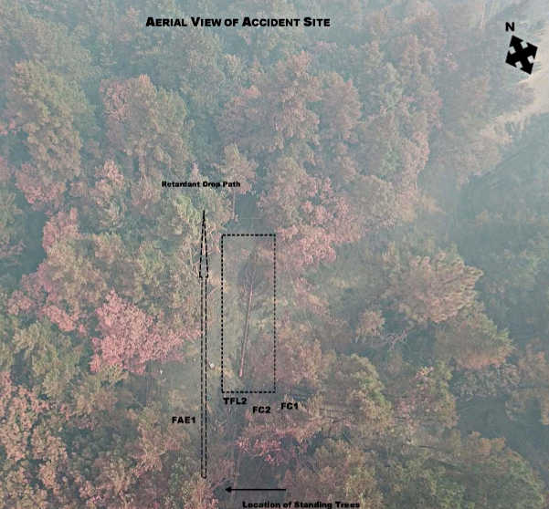
Cal Fire report says low retardant drop led to incident that killed firefighter on Mendocino Complex
LAKE COUNTY, Calif. – A Cal Fire report released Friday said the veteran Utah firefighter who died in August on the Mendocino Complex was killed by a tree that fell as the result of a low-altitude retardant drop.
Draper City Fire Battalion Chief Matthew Burchett, 42, died on the evening of Aug. 13 from injuries he sustained when he was hit by the falling tree on the Ranch fire portion of the Mendocino Complex, as Lake County News has reported.
The Cal Fire “green sheet” report issued Friday is published in its entirety below.
The report said that on the northwestern flank of the Ranch fire, aerial retardant drops were used to reinforce the dozer line.
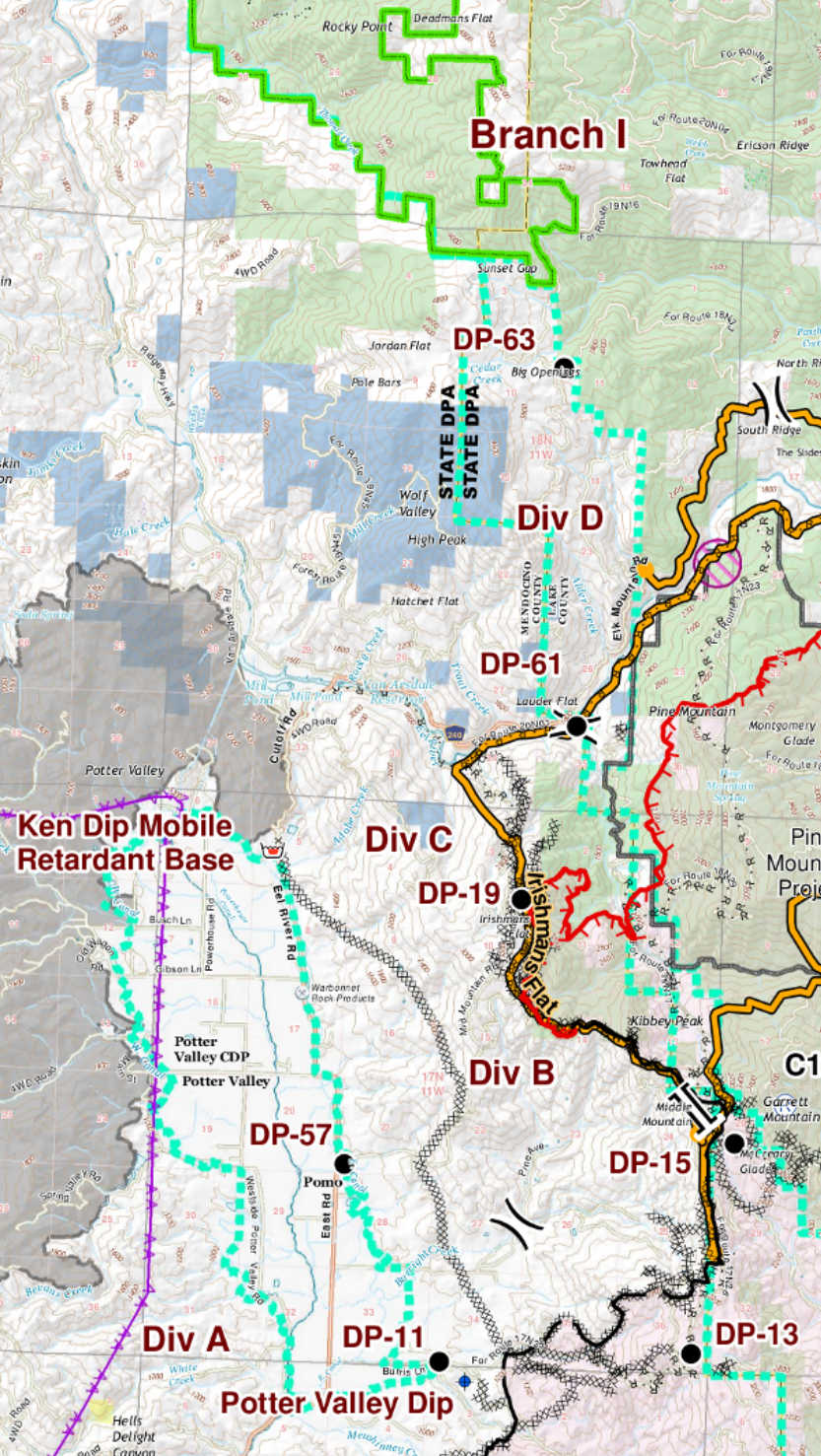
Burchett, who was leading a Utah multi-agency task force, and a strike team of type four engines from Kings County were assigned to the Ranch fire’s Branch I, Division C on the Mendocino County side of the fire in the Middle Mountain Range, approximately 500 yards north of Irishman’s Flat at an elevation of 3,000 feet.
During the retardant drops, Burchett was struck by an uprooted 87-foot-tall Douglas Fir tree. He was flown to Ukiah Valley Medical Center where he died a short time later.
Three other firefighters also were injured at the same time when they were hit by parts of another tree. They included two fire captains from a multiagency Utah group, one who suffered major injuries after being struck by a broken tree top and another who sustained moderate injuries – as did a fire apparatus engineer from Kings County – when hit by falling tree debris resulting from the retardant drop.
The air tanker that made the drop that led to the falling trees was a Boeing 747-400 configured as a very large air tanker, or VLAT, with a retardant capacity of 19,200 gallons, the report said.
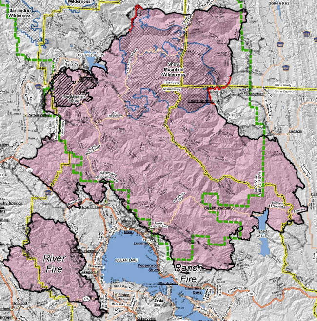
On the morning of the incident, the Mendocino Complex was 344,890 acres with 68-percent containment, which at that point broke down to 295,970 acres and 59-percent containment on the Ranch fire and 48,920 acres and 93-percent containment on the River fire, which was fully contained at that acreage the day after Burchett died.
Since Burchett’s death the complex has grown another 100,000 acres and continues to burn. On Friday it remained at 98-percent containment at a total of 459,123 acres. The Ranch fire remains the only active portion of the complex at 410,203 acres.
Report describes sequence of events
The report explained that, “due to unprecedented fire activity throughout the state,” on July 29 large resource orders were placed seeking assistance from areas including out of state. The Kings County strike team arrived July 30 and the Utah multi-agency task force arrived on Aug. 2.
The report said that on Monday, Aug. 13, the Utah multi-agency task force, with Burchett as leader, and the Kings County strike team were assigned to Branch I, Division C of the Ranch fire, located just west of the Mendocino-Lake County line.
At 7 a.m. that day, Burchett attended the operational briefing at the Mendocino Incident Base for the Ranch fire in Ukiah. The report said he and one of the fire captains who would later be injured along with him participated in the division breakout with the division supervisor and trainee at the Ranch Fire Incident Base.
“During the breakout, the Division C Line Safety Officer shared with all breakout attendees the hazards associated with airtanker retardant drops while working on the line,” the report said.
At 9 a.m., the report said the Utah multi-agency task force staged at Drop Point 19, located just northwest of Irishmans Flat. While staged, Burchett conducted a tailgate safety briefing and discussed the task force’s line assignment before the task force members moved to
their work location along Division C, a short distance to the north.
The report said the task force’s assignment was to reinforce dozer line and place a hose lay to hold a firing operation. Aircraft firefighting operations began on Division C at approximately 1 p.m. when the inversion layer lifted.
“Aircraft were requested to drop retardant adjacent to the dozer line as a reinforcement to hold the line,” the report said, explaining that coordination efforts were in place between Division C, Air Attack and the Aerial Supervision Module.
At 3:40 p.m., it was announced on the Division C tactical frequency that air tankers would be working the area, with a subsequent message broadcast to “clear the area out.” Only one strike team leader acknowledged hearing the broadcast, the report said.
The report said that at 4:02 p.m, 4:23 p.m. and 4:44 p.m. retardant drops were made in the Division C area by large air tankers. The last of those three drops took place approximately 300 feet to the west of the accident site and “landed further outside the dozer line than desired.”
The request was made for the next drop to be “‘snugged up’ closer to the dozer line,” the report said, adding that the Aerial Supervision Module “acknowledged the request and advised a closer drop would cause retardant to land on the dozer line.”
The Aerial Supervision Module “made a ‘show me’ run for the VLAT over the intended path for the retardant drop with the VLAT observing,” the report stated.
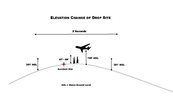
The report’s sequence of events explained that the Aerial Supervision Module “requested a coverage level six retardant drop and a minimum drop altitude at 3,200 feet mean sea level.”
At 5:25 p.m., the Aerial Supervision Module proceeded on a final approach over the drop path, identifying the drop path to the VLAT by use of a smoke trail, the report said.
“The VLAT initiated the retardant drop as identified by the smoke trail. Obscured by heavy vegetation and unknown to the VLAT pilot, a rise in elevation occurred along the flight path. This rise in elevation resulted in the retardant drop only being approximately 100 feet above the treetops at the accident site,” the narrative explained.
The report said the force of the retardant drop uprooted an 87-foot tall Douglas Fir with a 15-inch diameter at breast height, which fell on Burchett, mortally injuring him.
The drop also sheared an 89-foot tall, 18-inch diameter Douglas Fir 29 feet above the base, the debris from which hit one of the fire captains, who suffered broken ribs, deep muscle contusions and ligament damage to extremities. That falling tree also resulted in the second fire captain suffering scratches and abrasions, and the Kings County firefighter sustained deep muscle contusions and ligament damage, according to the report.
“Within seconds after the accident, an Incident Within an Incident (IWI) was declared. Injured personnel were treated by Advanced Life Support (ALS) providers assigned to resources on the division and then transported to the hospital for further treatment,” the report said.
Just before 5:30 p.m. that day, radio traffic Lake County News monitored on the Mendocino Complex included a report of a man hit by a tree on the dozer line with a need for immediate assistance and an IWI declared.
A few minutes later, radio reports from the accident scene said a medivac may be needed out of Drop Point 19, with a followup report shortly afterward stating that said they had an unconscious patient and were doing cardiopulmonary resuscitation on him. A medivac unit was then directed to respond to Drop Point 15, about six miles southwest of Lake Pillsbury, to transport him.
Minutes later, the major incident radio feed for the Mendocino Complex was cut off and would remain offline.
Officials later reported that Burchett was airlifted to Ukiah Valley Medical Center, where he died of his injuries.
At Burchett’s funeral the following week in Utah, when his fellow firefighters carried his gear in his funeral procession, it was stained bright red with retardant.
The report lists a number of safety issues for review, including, “Aerial drops are inherently hazardous and caution should be used when working in areas with aircraft operations,” adding that supervisors must ensure all fire line personnel are notified and acknowledge
impending aerial drops, that drop paths must be cleared when personnel are working under a tree canopy and that fire personnel need to always maintain situational awareness.
Under “incidental issues/lessons learned,” the report also noted, “Fireline personnel have used their cell phones to video the aerial retardant drops. The focus on recording the retardant drops on video may distract firefighters. This activity may impair their ability to recognize the hazards and take appropriate evasive action possibly reducing or eliminating injuries.”
Email Elizabeth Larson at
CA-MEU-009504 Firefighter Injuries and Fatality by LakeCoNews on Scribd
LAKE COUNTY, Calif. – Wildfire debris removal by CalRecycle will begin soon.
The state-coordinated program is available to property owners affected by the Pawnee, Ranch and River fires.
This program offers the opportunity for owners to prepare their property for rebuilding with no up front, out-of-pocket cost.
Participants are only responsible to file an insurance claim for the work performed by the state program, and retain and submit any insurance funds received for the program’s debris removal services at a later date.
Keeping and profiting from insurance money received for work performed by a public program is a “duplication of benefits,” a form of insurance fraud.
Those who wish to participate in the debris removal program must submit a right of entry, or ROE, form to the California Office of Emergency Services’ Debris Removal Operations Center or Lake County Environmental Health by Friday, September 28.
Pawnee, Ranch and River fire survivors with concerns or questions regarding the State’s program are encouraged to visit CalOES’ Debris Removal Operations Center , which is located at 898 Lakeport Blvd, next to Lake Family Resource Center and across from O’Meara Bros., in Lakeport.
The Debris Removal Operations Center is open Monday through Friday, 8 a.m. to 6 p.m., and Saturday, Sept. 22, from 8 a.m. to 1 p.m. Property owners can get all of their questions answered by trained personnel and complete and submit their ROE.
The Debris Removal Operations Center will be closed Saturday, Sept. 15.
Wildfire debris is hazardous to public health. If a property owner elects not to participate in the state’s program, they are still responsible to ensure that the debris is removed in a safe and timely manner, and the property is cleaned to a degree consistent with the standards of the government program.
Some private contractors offer debris removal services. If a property owner elects to use a private contractor, they still must reach out to Lake County Environmental Health, at 707-263-1164.
In some cases, private contractors require that the property owner bear significant out-of-pocket costs, so it is highly recommended that property owners work with Lake County Environmental Health to develop an actionable plan for debris removal in advance of the Sept. 28 ROE deadline.
Failure to remove wildfire debris that presents a threat to public health in a timely manner may result in the property being subject to abatement, which is typically the most costly option for a property owner.
Whatever their concerns, Pawnee, Ranch and River fire survivors are advised and encouraged to be proactive in this matter, and reach out to the Debris Removal Operations Center or Lake County Environmental Health with any questions.
The ROE can be viewed and printed online:
http://www.lakecountyca.gov/Assets/Departments/Health/EH+docs/Mendocino+Complex/Mendocino+Complex+Right+of+Entry.pdf.
CalOES’ Debris Removal Operations Center can be reached at 669-284-4501.
Lake County Environmental Health is located at 922 Bevins Court, Lakeport, and can be reached at 707-263-1164.
Pawnee, Ranch and River fire survivors in need of support understanding their options can also reach out to Lake County’s Recovery Coordinator Nathan Spangler at 916-521-7108.