How to resolve AdBlock issue?
News
- Details
- Written by: LAKE COUNTY NEWS REPORTS
The Slide 1 fire burning in the Yolla Bolly Middle Eel Wilderness is at 20% containment.
A recent reconnaissance flight has provided a more accurate picture of the fire’s size, which is at 473 acres.
Forest officials said fire behavior on Friday was mellow, and firefighters made progress on the line.
Firefighters are using a confine and contain strategy to keep the fire within the wilderness, building containment lines off of existing trails and natural barriers. This strategy helps to minimize risk and firefighter exposure in this challenging terrain.
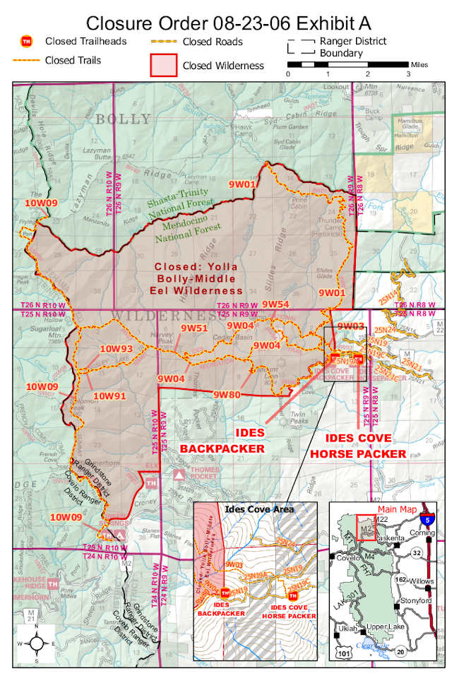
On Friday a closure was issued for roads, trails and recreation sites in the Yolla Bolly Middle Eel Wilderness within the Grindstone District to protect public safety and emergency operations.
With the opening of B zone archery season tomorrow, forest officials urge hunters to use caution and expect fire-related traffic on the M22 Road.
The Rock fire in the Sanhedrin Wilderness remains at an estimated 2.5 acres, and crews on scene are working to contain the fire.
Chance of showers and thunderstorms overnight were reported to be slight. Temperatures are trending down through the weekend, and there is potential for a cooler and wetter pattern early next week as Hurricane Hilary moves into the region.
Information about the forest closure, Slide 1 fire and other lightning-related fires is available on Inciweb: https://inciweb.wildfire.gov/incident-information/camnf-2023-slide-1.
Unless significant activity occurs, an update will be produced once daily starting tomorrow, Aug. 19.
- Details
- Written by: LAKE COUNTY NEWS REPORTS
The Slide 1 Fire, which began on Aug. 15 after more than 150 lightning strikes on the forest, prompted officials to issue the closure order.
Firefighters are actively using the roads, trails and recreation sites in the closure area.
Access for any recreation activities including hunting or hiking is prohibited in the closure area.
“We know it is hunting season, and people want to camp and hunt in their favorite spots. However, this closure is necessary to protect the public as well as our fire personnel from potential injury due to hazards in the fire area,” said Forest Supervisor Wade McMaster.
Except for this closure and the State Game Refuge, the rest of the forest is open to hunting during the seasons designated by the California State Department of Fish and Wildlife.
Officials also want to remind visitors that fire restrictions are in effect, prohibiting campfires, open flames or stove fires while dispersed camping. Within designated fire-safe recreation sites and wilderness areas, campfires are allowed with a valid permit.
The M22 Road remains open, however visitors should drive with caution and expect fire traffic.
Areas closed include:
Yolla Bolly Middle Eel Wilderness area within the Grindstone Ranger District
Ides Cove Backpacker Trailhead
Ides Cove Horsepacker Trailhead
Trails closed include:
9W01
9W03
9W04
9W51
9W54
9W80
10W09
10W93
10W91
Roads closed include:
25N14
25N24
25N19
25N19A
25N19C
25N21
25N21C
Emergency personnel on official duty and anyone with a permit specifically exempting them are exempted from this order.
- Details
- Written by: LAKE COUNTY NEWS REPORTS
With Hurricane Hilary forecasted to be the wettest tropical cyclone in state history and the first-ever tropical storm watch issued for California, the state is mobilizing to protect people from the storm and reminding everyone in the storm’s path to take steps now to prepare.
Hurricane Hilary — currently a powerful Category 4 storm — is forecast to track into Southern California over the weekend and into early next week, bringing moderate to heavy showers, thunderstorms and possibly stronger winds to Southern California.
Some parts of Southern California could receive a year’s worth of rain from this storm. The location and intensity of precipitation and winds will be variable as the hurricane approaches California.
At the same time, in the coming days, Lake County is forecast to experience showers and the potential for thunderstorms, along with cooler temperatures. However, the majority of the storm’s impact is expected to be to the east, the National Weather Service reported.
“We should never underestimate the power of Mother Nature,” said Gov. Gavin Newsom. “California is coordinating with federal and local governments to support communities as they prepare for this unprecedented storm. Heed warnings from local authorities, be ready and stay informed.”
Gov. Newsom is headed to Southern California and will be there for the next several days as the storm makes landfall.
At Newsom’s direction, the State Operations Center at the Governor’s Office of Emergency Services, or Cal OES, is currently activated and the state is closely monitoring incoming impacts from rain, wind, and potential flash flooding and power outages.
The State Operations Center is actively coordinating across state agencies to provide resources in preparation for potential impacts and to support response and recovery efforts.
In coordination with locals, the state is prepositioning resources including swift water rescue teams, California National Guard teams, and flood fighting tools while also working closely with community-based organizations to protect vulnerable unhoused people.
Additionally, California is staffing highway maintenance crews 24 hours a day and taking proactive steps to maintain roadway safety.
Here are the top 5 things you can do to stay safer during the storm:
Stay connected. Californians are reminded to dial 3-1-1 to get help or ask questions. If you have a critical emergency, call 911. Stay informed by signing up for emergency alerts including warnings and evacuation notices. Go to CalAlerts.org to sign up to receive alerts from your county officials. Check in with loved ones and neighbors.
Prepare for high winds and ocean surges. Before a high wind event occurs: remove any dead trees or overhanging branches near structures, remove loose roofing material, bring in unsecured objects from patios and balconies, secure outdoor objects that could blow away, shutter windows securely and brace outside doors.
During a high wind event: take cover next to a building or under shelter, stay away from windows, stay clear of roadways and train tracks, avoid elevated areas such as roofs, watch for flying debris.
Avoid the ocean: The National Weather Service has issued a high surf advisory and is urging beachgoers to stay out of the ocean as Hurricane Hilary will create strong breaking waves, shore breaks and strong longshore and rip currents, making the ocean extremely dangerous.
Travel safely. Avoid non-essential travel during the peak of the storm expected Sunday and Monday. If you must drive, download the QuickMap app or visit QuickMap (ca.gov) to learn up-to-the-minute information on road conditions, traffic, closures, and more. Do not walk, swim or drive through flood waters. Turn Around, Don’t Drown! Remember, just six inches of moving water can knock you down, and one foot of moving water can sweep your vehicle away.
Be ready in case of power outages. Take inventory of the items you need that rely on electricity. Keep your devices charged. Plan for batteries and other alternative power sources to meet your needs if the power goes out such as a portable charger or power bank. Have flashlights for every household member. Also, plan accordingly for the potential of water outages.
Listen to local authorities. Always follow the guidance of your local authorities, including evacuation orders, road closures and other official notices.
- Details
- Written by: NATIONAL AERONAUTICS AND SPACE ADMINISTRATION
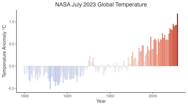
According to scientists at NASA’s Goddard Institute for Space Studies (GISS) in New York, July 2023 was hotter than any other month in the global temperature record.
“Since day one, President Biden has treated the climate crisis as the existential threat of our time,” said Ali Zaidi, White House national climate advisor. “Against the backdrop of record high temperatures, wildfires, and floods, NASA’s analysis puts into context the urgency of President Biden’s unprecedented climate leadership. From securing the Inflation Reduction Act, the largest climate investment in history, to invoking the Defense Production Act to supercharge domestic clean energy manufacturing, to strengthening climate resilience in communities nationwide, President Biden is delivering on the most ambitious climate agenda in history.”
Overall, July 2023 was 0.43 degrees Fahrenheit (F) (0.24 degrees Celsius (C)) warmer than any other July in NASA’s record, and it was 2.1 F (1.18 C) warmer than the average July between 1951 and 1980.
The primary focus of the GISS analysis are long-term temperature changes over many decades and centuries, and a fixed base period yields anomalies that are consistent over time. Temperature "normals" are defined by several decades or more — typically 30 years.
“NASA data confirms what billions around the world literally felt: temperatures in July 2023 made it the hottest month on record. In every corner of the country, Americans are right now experiencing firsthand the effects of the climate crisis, underscoring the urgency of President Biden’s historic climate agenda,” said NASA Administrator Bill Nelson. “The science is clear. We must act now to protect our communities and planet; it’s the only one we have.”
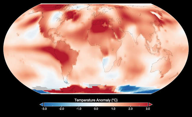
Parts of South America, North Africa, North America, and the Antarctic Peninsula were especially hot, experiencing temperatures increases around 7.2 F (4 C) above average.
Overall, extreme heat this summer put tens of millions of people under heat warnings and was linked to hundreds of heat-related illnesses and deaths.
The record-breaking July continues a long-term trend of human-driven warming driven primarily by greenhouse gas emissions that has become evident over the past four decades. According to NASA data, the five hottest Julys since 1880 have all happened in the past five years.
“Climate change is impacting people and ecosystems around the world, and we expect many of these impacts to escalate with continued warming,” said Katherine Calvin, chief scientist and senior climate advisor at NASA Headquarters in Washington. “Our agency observes climate change, its impacts, and its drivers, like greenhouse gases, and we are committed providing this information to help people plan for the future.”
NASA assembles its temperature record from surface air temperature data from tens of thousands of metrological stations, as well as sea surface temperature data acquired by ship- and buoy-based instruments.
This raw data is analyzed using methods that account for the varied spacing of temperature stations around the globe and for urban heating effects that could skew the calculations.
“This July was not just warmer than any previous July – it was the warmest month in our record, which goes back to 1880,” said GISS Director Gavin Schmidt. “The science is clear this isn’t normal. Alarming warming around the world is driven primarily by human-caused greenhouse gas emissions. And that rise in average temperatures is fueling dangerous extreme heat that people are experiencing here at home and worldwide.”
High sea surface temperatures contributed to July’s record warmth. NASA’s analysis shows especially warm ocean temperatures in the eastern tropical Pacific, evidence of the El Niño that began developing in May 2023. Phenomena such as El Niño or La Niña, which warm or cool the tropical Pacific Ocean, can contribute a small amount of year-to-year variability in global temperatures.
But these contributions are not typically felt when El Niño starts developing in Northern Hemisphere summer. NASA expects to see the biggest impacts of El Niño in February, March, and April 2024.
For more information on NASA’s global temperature record, visit https://www.nasa.gov/feature/2023/climate-media-resources.