How to resolve AdBlock issue?
Refresh this page
How to resolve AdBlock issue?
Refresh this page
Lake County News,California
  • Home
    • Registration Form
  • News
    • Education
    • Veterans
    • Community
      • Obituaries
      • Letters
      • Commentary
    • Police Logs
    • Business
    • Recreation
    • Health
    • Religion
    • Legals
    • Arts & Life
    • Regional
  • Calendar
  • Contact us
    • FAQs
    • Phones, E-Mail
    • Subscribe
  • Advertise Here
  • Login
How to resolve AdBlock issue?
Refresh this page

News

EVs are lowering Bay Area's carbon footprint

Details
Written by: Robert Sanders
Published: 12 May 2024
Electrification of passenger vehicles in the Bay Area is slowly driving down CO2 emissions, though not enough to meet the state's ambitious climate goals. Photo credit: Mike Bird via Pexels.

An extensive CO2 monitoring network set up around the San Francisco Bay Area by an atmospheric chemist from the University of California, Berkeley, has recorded the first evidence that the adoption of electric vehicles is measurably lowering the area's carbon emissions.

The network of sensors, most of them in the East Bay, is the brainchild of Ronald Cohen, UC Berkeley professor of chemistry, who envisions inexpensive, publicly funded pollution and carbon dioxide monitors widely distributed around urban areas to pinpoint emission sources and the neighborhoods most affected.

An estimated 70% of global CO2 emissions come from cities, yet few urban areas have granular data about where those emissions originate.

In 2012, Cohen began setting up a Bay Area sensing network that has now grown to more than 80 stations, including seven in San Francisco, that stretches from Sonoma County through Vallejo and down to San Leandro.

Between 2018 and 2022, 57 of the sensors in the Berkeley Environmental Air Quality and CO2 Network, or BEACO2N, recorded a small but steady decrease in CO2 emissions — about 1.8% annually — that translates to a 2.6% yearly drop in vehicle emission rates.

Looking at California data for electric vehicle adoption — which is very high in the Bay Area — Cohen and graduate student Naomi Asimow concluded that the decrease was due to passenger vehicle electrification.

“That's 2.6% less CO2 per mile driven each year,” said Asimow, who is in the Department of Earth and Planetary Science.

The study, Cohen said, shows the utility of an urban network for monitoring and managing federal, state and city mandates for CO2 reduction.

“We show from atmospheric measurements that adoption of electric vehicles is working, that it's having the intended effect on CO2 emissions,” Cohen said.

This good news is tempered by the fact that, to meet California and Bay Area carbon reduction goals, the yearly decrease needs to be much greater.

“The state of California has set this goal for net zero emissions by 2045, and the goal is for 85% of the reduction to come from actual reduction of emissions, as opposed to direct removal of CO2 from the atmosphere. What we report is around half as fast as we need to go to get to net zero emissions by 2045,” Asimow said.

“We're at 1.8% per year today. To get to the state's goal, we would need 3.7%,” Cohen added. “So it's not crazy higher than where we are; we're almost half of the way to that goal. But we have to sustain that for another 20 years.”

The results emphasize the urgent need for accelerated actions to reduce CO2 in order to achieve the ambitious zero emission targets that cities seek, he said.

Asimow, Cohen and their colleagues published their findings online today, April 4, in the journal Environmental Science & Technology.

How to monitor climate goals

One impetus for the study was to see whether the BEACO2N network could detect any downward trend in vehicle emissions since the state set goals for greenhouse gas reduction and the electric vehicle market has blossomed.

“We were curious if our data would show us our progress toward meeting California's emissions goals,” Asimow said.

Typically, CO2 emissions are estimated from known sources of carbon: how much gas is used in heating and, for vehicles, the fuel efficiency of registered vehicles in an area and overall fuel consumption.

Asimow and Cohen noted that this "bottom-up" method for estimating carbon dioxide emissions did not predict the small but significant downward trend in CO2 emissions.

The UC Berkeley team's estimates combined direct CO2 measurements with meteorological data to calculate ground-level emissions — an approach using atmospheric observations that did pick up the modest downturn in CO2 levels.

The researchers employed a Bayesian statistical analysis that started with estimates based on economic data, but they revised them based on their network's measured CO2 concentrations and a meteorological model to predict where the emissions originated.

Cohen argues that his sensors are inexpensive enough — less than $10,000 per sensor, versus 20 times as much for pollution monitoring stations operated by the Environmental Protection Agency — that major cities could afford to install a network to get a more granular view of unhealthy areas and sources of pollution.

The network sensors also measure five critical air pollutants: carbon monoxide, nitrous oxides (NO and NO2), ozone and particulates (PM 2.5).

Los Angeles, California; Providence, Rhode Island; and Glasgow, Scotland, have already adopted Cohen's sensors to create their own pollution monitoring networks.

"We show that you can make observations and measure changes due to policies of all kinds in a cost-effective and relatively rapid way," Cohen said. "The network involves about half a million dollars' worth of equipment — a one-time investment — and a person per year thinking about it. One of our goals is to demonstrate, both on the CO2 and the air quality side of what we do, that this is cost-effective and translatable and easily accessible to the public in a way that nothing else is."

In the future, satellites could monitor carbon dioxide levels across wide areas and with more granularity, but those satellites are not yet available, Cohen said.

"The optimal solution will be some combination of space-based assets and ground-based measurements," he said.

Asimow was supported by a National Science Foundation Graduate Research Fellowship (1752814). Former Miller Postdoctoral Fellow Alexander Turner, now at the University of Washington in Seattle, also contributed to the research.

Robert Sanders writes for the UC Berkeley News Center.

Helping Paws: Retrievers, shepherds and terriers

Details
Written by: Elizabeth Larson
Published: 12 May 2024
LAKE COUNTY, Calif. — Lake County Animal Care and Control has many dogs waiting for new homes this week.

Dogs available for adoption this week include mixes of Alaskan husky, Anatolian shepherd, Chesapeake Bay retriever, Chihuahua, German shepherd, hound, Labrador Retriever, pit bull terrier, Rottweiler and terrier.

Dogs that are adopted from Lake County Animal Care and Control are either neutered or spayed, microchipped and, if old enough, given a rabies shot and county license before being released to their new owner. License fees do not apply to residents of the cities of Lakeport or Clearlake.

Those dogs and the others shown on this page at the Lake County Animal Care and Control shelter have been cleared for adoption.

Call Lake County Animal Care and Control at 707-263-0278 or visit the shelter online for information on visiting or adopting.

The shelter is located at 4949 Helbush in Lakeport.

Email Elizabeth Larson at This email address is being protected from spambots. You need JavaScript enabled to view it.. Follow her on Twitter, @ERLarson, or Lake County News, @LakeCoNews.

 
Kennel #18's preview photo
Kennel #18

Kennel#8's preview photo
Kennel#8

Kennel#21's preview photo
Kennel#21

Kennel#12's preview photo
Kennel#12

Kennel#27(a)'s preview photo
Kennel#27(a)

Kennel#27(b)'s preview photo
Kennel#27(b)

Kennel#16(Beau)'s preview photo
Kennel#16(Beau)

Kennel#5's preview photo
Kennel#5

Kennel#22's preview photo
Kennel#22

Kennel#26's preview photo
Kennel#26

 
Kennel#30's preview photo
Kennel#30

Kennel#6's preview photo
Kennel#6


Kennel#24's preview photo
Kennel#24

Kennel#19's preview photo
Kennel#19


Kennel#14's preview photo
Kennel#14

Kennel#23's preview photo
Kennel#23

Kennel#4's preview photo
Kennel#4

Kennel#31's preview photo
Kennel#31

 
Kennel#32's preview photo
Kennel#32

 
Kennel#7(Boddie)'s preview photo
Kennel#7(Boddie)

Kennel#25(Napa)'s preview photo
Kennel#25(Napa)


What are roads made of? A pavement materials engineer explains the science behind the asphalt you drive on

Details
Written by: Mansour Solaimanian, Penn State
Published: 12 May 2024


Pavers push the asphalt down during road construction. Pramote Polyamate/Moment via Getty Images

While on the road, you’re probably thinking more about your destination than the pavement you’re driving over. But building roads requires a host of engineering feats, from developing the right pavement materials to using heavy equipment to lay them down. The better they’re built, the longer roads last and the fewer construction delays drivers have to endure.

I am an engineer who does research on materials used in roads. Scholars in my field are working to develop materials that can make roads stronger and last longer.

Road materials

So, what are roads really made of? The simple answer is that they are made of typical construction materials such as aggregates – soils and rocks – as well as asphalt binder and Portland cement, which act like glue to bond it all together.

Asphalt binder is refined from crude oil. From crude oil, refiners first extract gasoline, kerosene and oil, and what remains at the bottom becomes the asphalt. Portland cement is manufactured using several different ingredients, including limestone, sand, clay, silica and alumina.

Engineers compact the mixture of asphalt binder and aggregates together at an elevated temperature, about 300 degrees Fahrenheit (150 degrees Celsius), which glues the aggregates together into the final product, called asphalt concrete.

If they’re using Portland cement rather than asphalt binder to glue the aggregates together, the engineers cure the mixture of the cement and aggregates with water through a process called hydration.

Hydration bonds the cement to the aggregates to make the product, called Portland cement concrete, stronger. With this process, there’s no external heating involved.

Pavement structure

Asphalt concrete’s pavement structure typically has three main layers: the base layer, the intermediate layer and the surface layer.

A diagram showing five distinct pavement layers, including the surface, intermediate and base layers of the concrete, and then the sub-base and subgrade.
The layers that make up pavement. Mansour Solaimanian

Engineers call the existing ground where the pavement goes the subgrade. On top of the subgrade goes a new layer of unbound soil and stone, where the aggregates aren’t glued together. This is called the subbase, or unbound aggregate base.

The base layer can be either stones packed together without any binding agent or a combination of stone and asphalt binder.

Once road builders make the base, it is time to build the asphalt concrete layers: the base layer, the intermediate layer and the surface layer. All these layers contain the aggregates – the pieces of rock and sand – glued together with the asphalt binder in some way.

Engineers determine how many layers to build and how thick to make each layer by figuring out how much traffic will drive over the road. The more traffic, the thicker the pavement needs to be. For example, on interstate highways, the depth of the layers combined could be 20 inches (51 centimeters) or more.

A machine drives over dark pavement.
The asphalt concrete base layer is placed and compacted by a paver. Mansour Solaimanian

Building a strong road

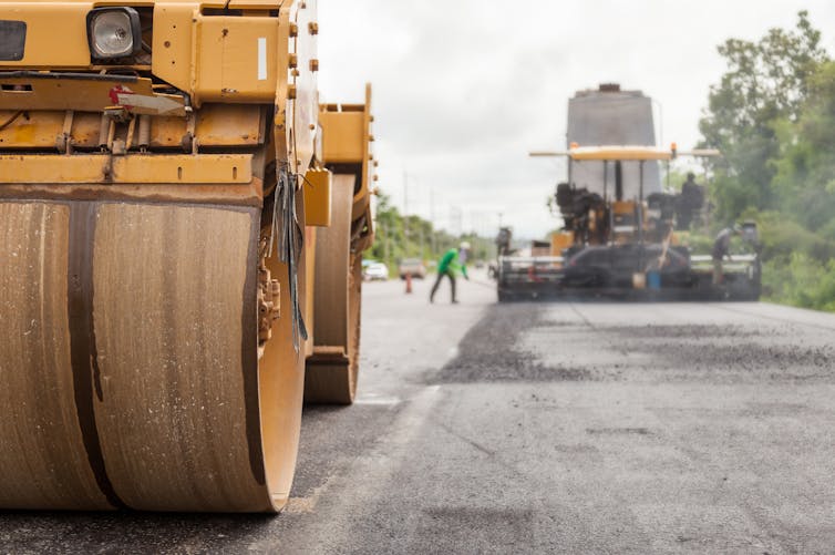
The road builders place the material on the road with an asphalt paving machine called a paver. An operator runs the paver, which takes the materials from a truck and places them on the road. After that, heavy-duty rollers compact it down, make it strong and get it ready for vehicles.

For a strong and durable road, engineers first pick the best subgrade, or place on top of which to build pavement. If the subgrade is too weak, the road might crack and fail – even if the pavement uses the best materials.

A sandy, grain-like material packed on the ground where a road will go.
Engineers compact the subgrade before the paving process. Mansour Solaimanian

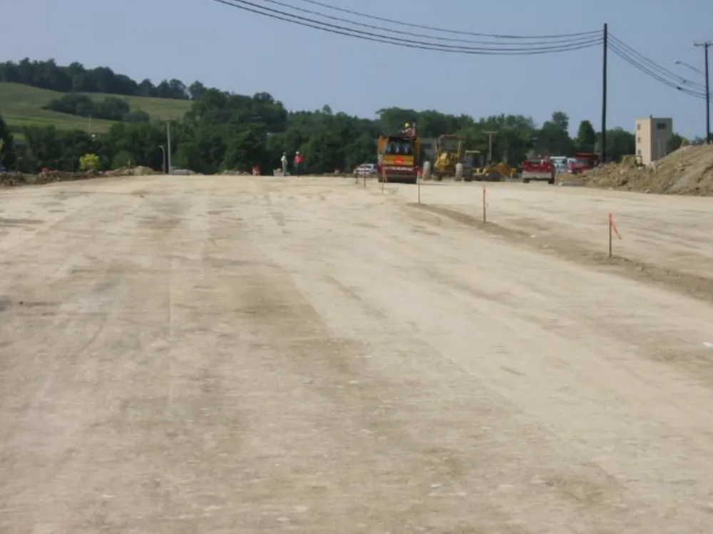
First, the road builders use rollers to pack the subgrade down. Once they’ve compacted the subgrade, they place the stone aggregates directly on top of the subgrade and compact them down. This aggregate base on the subgrade provides a sturdy foundation for the asphalt layers.

If the road builders do not use the right materials, or do not put them together correctly, or do not design the pavement structure for the expected traffic, then the road can crack, rut and fail.

Cracking occurs either at extremely low temperatures or from heavy trucks and buses repeatedly driving over the road. Rutting, which refers to noticeable impressions in the road’s surface, occurs mostly during summer heat under heavy trucks or at road intersections.

Potholes are a big road problem you’ve probably seen before. They often show up in the spring after water trapped in the pavement freezes over winter and then melts in spring. This melting process weakens the road, making it more breakable. Then, when vehicles drive over it, they can create potholes.

A road with a web of cracks in it.
The road may crack over time and with repeated use. Mansour Solaimanian
A car driving over a deep indent in the road.
Rutting, like the indent at this intersection, happens when the road is exposed to standing vehicles. Mansour Solaimanian

Before the road gets built, the materials undergo testing in a laboratory to make sure they can stand the loads from traffic and environment.

A piece of equipment with 4 patches of pavement inside.
Lab testing of the road materials includes wheel tracking under water to make sure the materials hold up. Mansour Solaimanian

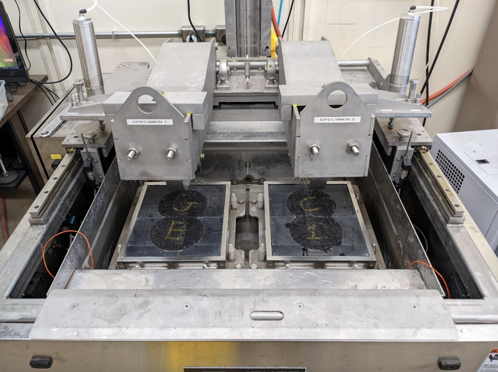
Engineers in the lab expose the pavement materials to both freezing and very hot temperatures to make sure they can withstand any weather. They also expose the pavement materials to water to make sure the materials will not fall apart if it rains or floods.

At the Penn State pavement laboratory, my team is testing asphalt mixtures to which we’ve added substances called modifiers. These include special polymers and fibers that could make the road stronger.

The next time you’re on the road, remember that it takes a good amount of engineering and tremendous teamwork to create that smooth pavement surface you drive on.The Conversation

Mansour Solaimanian, Research Professor, Larson Pennsylvania Transportation Institute, Penn State

This article is republished from The Conversation under a Creative Commons license. Read the original article.

Space News: NASA field geology training prepares Artemis mission support teams

Details
Written by: Rachel Barry
Published: 12 May 2024
A small team of participants in the Geology 101 field training gather on a large pile of rocks from a lava flow. Photo by NASA/Robert Markowitz.

NASA engineers, managers, and flight directors recently traded their cubicles and conference rooms for an ancient volcanic field in the northern Arizona desert to participate in a field geology course aimed at arming them with first-hand experience in what Artemis astronauts will do when they explore the Moon.

The two-and-a-half-day exercise for Artemis mission support teams was a condensed version of the rigorous training astronauts receive to prepare for Artemis missions to the lunar South Pole region, but shares an important purpose.

“We are building a common language and a common understanding of what it will be like to do field geology on the surface of the Moon,” said Cindy Evans, Artemis geology training lead at NASA’s Johnson Space Center in Houston. “This is so the people who are building spacesuits, building tools, building software systems, the people who will be flight controllers, and the managers who direct and fund all of this, can all understand the interlocking parts of surface exploration.”

Small teams led by geology experts from NASA, the USGS (U.S. Geological Survey), and academia studied maps, built hypotheses about the geologic history of the area, and trekked for miles to test whether those hypotheses match reality. This field test required smashing rocks with hammers to study their mineral makeup, and carefully selecting a few to examine further after returning from the field in the same way Artemis astronauts will return samples from the Moon.

Geology studies help uncover the rich physical history of an area. Each rock type represents a process and the order of layering of those rocks reveals a story that could unlock a planet’s secrets, offering clues for how it was formed and evolved over time.

“The Moon doesn’t have an atmosphere or flowing water like we have here on Earth, and doesn’t have plate tectonics, which are processes that erase a lot of the evidence from the early Earth,” said Jacob Bleacher, chief exploration scientist in the Exploration Systems Development Mission directorate at NASA Headquarters in Washington. “The Moon still has that evidence, so we can go to the Moon and learn lessons about our home planet that we can’t learn here on the Earth.”

In the desert, as the mission support team members practiced the fundamental methods used by geologists to study an environment, they pieced together the story of the region. The planned walking paths, known as traverses, frequently changed based on what they were finding.

Artemis curation lead Juliane Gross, left, NASA flight controller Grant Harman, center, and imagery scientist Marco Lozano collect and examine samples during the Geology 101 field course. Photo by NASA/Robert Markowitz.

Teams embraced the principle of “flexecution” — or flexible execution — a practice that could come into play as astronauts explore the lunar surface and report findings to a backroom of scientists supporting the mission in the Mission Control Center at Johnson, referred to as the science evaluation room.

“The geologists will be the science evaluation room during Artemis missions, assimilating real-time mission data to understand the observations, tracking the samples, going back to the maps that they’ve built trying to understand how all those pieces fit together on a day-by-day and traverse-by-traverse basis,” said Evans. “When the astronauts return home with the samples and with their full observations, the scientists can hit the ground running to address key science questions.”

With Artemis, NASA will study the history of the Moon and its relationship with Earth and build a blueprint for deeper space exploration.

“What we’re doing now is laying the groundwork for long-term exploration at the Moon,” Bleacher said. “Laying that groundwork will then help us explore other destinations like Mars. The Moon is a part of everything that we understand here on the Earth. It’s also an anchor point to help us understand how to interpret everything else in the solar system.”

NASA conducts field tests in locations on Earth that have lunar-like landscapes to test a variety of operations and procedures, as well as new technologies, before leaving Earth for Artemis missions on the Moon. In addition to this geology training to build a foundation for mission support teams, another team will conduct simulated moonwalks in the Arizona desert this spring with mockup spacesuits to test hardware and new capabilities, like a heads-up display using augmented reality, for future Artemis missions.

Through Artemis, NASA will send astronauts – including the first woman, first person of color, and its first international partner astronaut – to explore more of the lunar surface than ever before prepare for human missions to Mars for the benefit of all.

Rachel Barry works for the Johnson Space Center.

NASA Flight Director Diane Dailey examines a rock at the Geology 101 field training for Artemis mission support teams in the northern Arizona desert. Photo by NASA/Robert Markowitz.
  1. Aurora borealis lights up Lake County’s sky
  2. Ingram named Lake County Teacher of the Year
  3. California Highway Patrol swears in 106 new CHP officers
  • 684
  • 685
  • 686
  • 687
  • 688
  • 689
  • 690
  • 691
  • 692
  • 693
How to resolve AdBlock issue?
Refresh this page