How to resolve AdBlock issue?
News
CLEARLAKE, Calif. – Cal Fire and the U.S. Forest Service are planning another meeting to update the community on progress to contain the Mendocino Complex.
The meeting will take place at 6 p.m. Friday, Aug. 3, at the Clearlake Senior Community Center, 3245 Bowers Ave.
With the complex – composed of the Ranch and River fires – continuing to burn actively in lands overseen by both Cal Fire and the Forest Service, the two agencies are now in unified command.
Officials will discuss the situation on the fire, discuss the current work of firefighters, answer questions, display current maps and offer operational handouts.
Community members are asked to arrive early, as the meeting will start promptly at 6 p.m.
If you have questions about the meeting, please call the Mendocino Complex Fire Information Line 707-574-8261.
Email Elizabeth Larson atThis email address is being protected from spambots. You need JavaScript enabled to view it. . Follow her on Twitter, @ERLarson, or Lake County News, @LakeCoNews.
The meeting will take place at 6 p.m. Friday, Aug. 3, at the Clearlake Senior Community Center, 3245 Bowers Ave.
With the complex – composed of the Ranch and River fires – continuing to burn actively in lands overseen by both Cal Fire and the Forest Service, the two agencies are now in unified command.
Officials will discuss the situation on the fire, discuss the current work of firefighters, answer questions, display current maps and offer operational handouts.
Community members are asked to arrive early, as the meeting will start promptly at 6 p.m.
If you have questions about the meeting, please call the Mendocino Complex Fire Information Line 707-574-8261.
Email Elizabeth Larson at
This story will be updated on a rolling basis until 11:59 p.m. Friday, Aug. 3.
LAKE COUNTY, Calif. – This is the Mendocino Complex general information update for Friday, Aug. 3.
Cal Fire said Friday morning that the complex had reached 153,738 acres and 30-percent containment. The Ranch fire is 112,226 acres and 28-percent contained, the River fire is 41,512 acres and 50-percent contained.
The following summary includes updated information on sheltering for humans and animals, air quality, road closures, reconnecting with friends and family after an evacuation, where to donate and volunteer, prescriptions and important information numbers, including how to contact local emergency operation centers.
To suggest additions to this resource and information list, please contact Editor and Publisher Elizabeth Larson at
AIR QUALITY
The Lake County Air Quality Control District has issued an air quality alert for Lake County due to heavy smoke that has resulted in “very unhealthy” and “hazardous” conditions and the forecast for extended smoke impacts, and impacts from other air pollutants in the smoke lingering in Lake County until conditions change.
The district said smoke levels continue to exceed the Air Quality Index maximum range. With particulate levels this high, everyone needs to take steps to protect themselves from exposure.
EMERGENCY OPERATION CENTERS/PUBLIC INFORMATION
County of Lake Emergency Operations Center: 707-263-3450
City of Lakeport Lake Emergency Operations Center (24/7): 707-263-5683
Cal Fire Public Information Line: 707-574-8261
Caltrans: http://quickmap.dot.ca.gov/ or http://www.dot.ca.gov/cgi-bin/roads.cgi; 800-427-7623
Pacific Gas and Electric online outage center: https://m.pge.com/#outages
EVACUATIONS
MANDATORY
Anyone who remains in the areas under mandatory evacuation orders must remain on their property. Any unauthorized person who willfully and knowingly enters a disaster area and who willfully remains within the area after receiving notice to evacuate or leave shall be guilty of a misdemeanor.
Updated 7 p.m.
Lake County
• For the Lucerne, Pepperwood Grove, Paradise Valley, Glenhaven and Clearlake Oaks areas of Lake County, including Long Valley, High Valley and Spring Valley: All areas north of Clear Lake, south and east of Bartlett Springs Road at Highway 20, west of Bartlett Springs Road at the Indian Valley Reservoir, south to New Long Valley Road and Highway 20 at Highway 53.
• Western Lake County, north of Clear Lake and Bartlett Springs Road, east of the Lake-Mendocino County line, south of the Ranch Fire, and west of High Valley Road and Bartlett Springs Road.
• Bartlett Springs Road at Highway 20, east along the National Forest boundary to High Valley Road, southeast to the 5 Star Fish Farm, southeast to the north side of Highway 20, east to New Long Valley Road, extending north to the west side of the Indian Valley Reservoir, north to Bartlett Springs Road, east to the Lake-Colusa County line, north along the Lake-Colusa County Line extending to Forest Service Road 18N40 (west of the Lake-Colusa-Tehama County line), and west to the western National Forest boundary in Lake County.
• Scotts Valley, Blue Lakes, Upper Lake, Bachelor Valley and Nice.
• South of Bartlett Springs Road at Highway 20, west of the Forest Boundary, including Pierce Canyon and High Valley Road, west of Sulphur Bank Drive at Hwy 20 and north of Clear Lake.
• West of Highway 29 and north of Park Way.
Mendocino County
• Cow Mountain area of Mendocino County, south of Highway 20, west of the Mendocino/Lake County line, east of the intersection of North Cow Mountain Road and the Cow Mountain Access Road, and north of the current fire perimeter of the River fire.
• Highway 20 area from one mile south of Highway 20, east of Potter Valley Road, south of the fire perimeter, and west of Mendocino-Lake County line.
ADVISORIES/WARNINGS
Lake County
• Lake Pillsbury basin and surrounding areas.
• Southeast Lakeport, north of Highway 29 at Highland Springs Road, east of Highway 29, south of Park Way, and west of Clear Lake
• South of Hallberg Road, west of Highway 29, north of Highway 175, and east of the River fire perimeter.
• South of Highway 29 and Highway 175, west of Highland Springs Road, north and east of the Lake-Mendocino County line, and east of the River fire perimeter.
Mendocino County
• South of the Eel River, east of the Eel River Road, east of the East Side Potter Valley Road, east of Potter Valley Road to Highway 20, north of Highway 20, west of the Mendocino-Lake
County line.
• South of the fire perimeter, east of intersection Highway 175 and Old River Road, north of Mendocino-Sonoma County line, west of Mendocino/Lake County line.
• South of Yokayo Ranch Road, east of the Russian River, west of the Lake-Mendocino County line, north of the Old River Road-Highway 175 intersection.
• East Ukiah Valley area, south of Highway 20, east of the east side of Lake Mendocino and east of the Russian River, north of Yokayo Rancheria Road, and west of the intersection of North Cow Mountain Road and Cow Mountain Access Road.
Colusa County
• East of the Lake-Colusa County Line (Bartlett Springs Road/Brim Road) to Leesville-Lodoga Road, north to Lodoga, west to the National Forest boundary, north along the National Forest boundary to the Colusa-Glenn County Line, and west to the Colusa-Lake County line.
EVACUATION SHELTERS
Evacuation shelters offer overnight accommodations.
• Mendocino College, Dance Room, 1000 Hensley Creek Road, Ukiah
• Lower Lake High School, 9430 Lake St.
• Middletown High School, 20932 Big Canyon Road.
• **At Capacity ** Twin Pine Casino, 22223 Highway 29, Middletown- LCSO 12:30 p.m. Friday DIVERT to Middletown or Lower Lake High Schools.
• Mountain Vista Middle School, 5081 Konocti Road in Kelseyville.
CONNECTING WITH FRIENDS AND FAMILY AFTER EVACUATIONS
The Safe and Well locating service from the American Red Cross is now active.
Visit https://safeandwell.communityos.org/cms/index.php to list yourself as safe, using the Mendocino Complex Fire-July 2018 Disaster Event.
If you’re looking for someone, use the same link and click on “Search Registrants.”
ANIMAL EVACUATIONS
Lake County
Large livestock can be taken to Cole Creek Equestrian Center, 4985 Steelhead Drive, Kelseyville, telephone 707-279-0915; or to Helen Owens’ A1 Horse Programs, 18585 Guenoc Lane, Hidden Valley Lake, telephone 707-355-0121.
Lake Evacuation and Animal Protection has been activated and is still offering animal evacuation support services. Call Lake County Animal Care and Control Department at 707-263-0278. Phones are answered by staff between 8 a.m. and 11 p.m.
The Animal Care and Control Shelter is not accepting pets at this time.
The SPCA of Clear Lake, 8025 Highway 29, is open 9 a.m. to 6 p.m. daily and is accepting senior pets, or pets with medical issues and/or heat distress.
If you can keep your pets with you, please do so. Pet supplies are delivered to all open evacuation shelters regularly.
Mendocino County
Redwood Riders Arena, 8300 East Road, Redwood Valley is accepting horses.
Mendocino County Animal Care, 298 Plant Road, Ukiah is accepting small animals.
ROAD CLOSURES
Updated at 7:15 p.m.
Lake County
• Southbound Elk Mountain to south Pillsbury Lake
• Elk Mountain Road at Middle Creek Road
• Westbound Highway 20 at Highway 29
• Northbound Highway 29 at Park Way
• Northbound Highway 29 at Park Way
• Northbound Lakeshore Boulevard at Park Way
• Northbound Hill Road at Park Way
• Scotts Valley Road at HIll Road
• Highway 20 at Sulphur Bank Road
• Old Long Valley Road at Highway 20
• Walker Ridge Road at Highway 20
• Westbound Highway 20 at Highway 53
• Hill Road at Hill Road East
• Argonaut Road at Highway 29
• Highland Springs Road at Highway 29
• High Valley Road north of Highway 20
• Martin at Shirley
• 11th Street at Mountain View Road
• Hill Road at Hill Road East
• Ackley Road at Highway 29
• Round Mountain Road at Highway 20
• Morine Ranch Road at Highway 20
• New Long Valley Road at SR 20
Mendocino County
• Eastbound Highway 20 at Potter Valley Road
• Mill Creek Road, half a mile east of Old River Road
UNITED STATES POSTAL SERVICE – MAIL DELIVERY
Lake County residents normally served by Post Offices in Lakeport, Nice and Upper Lake can pick up their mail at the Clearlake Post Office, 14500 Olympic Drive. Pick up times are 1 to 5:30 p.m. Monday through Friday, and 1 to 4 p.m. on Saturday. Photo identification will be required.
The Kelseyville and Finley Post Offices have resumed normal service.
PRESCRIPTIONS
State law allows for residents in declared emergency areas to fill prescriptions at available pharmacies, even if it is not where your prescription is on file.
Please bring your medication bottle(s) and/or the actual medication with you to help the pharmacist fill your prescription. The pharmacist will contact your physician for confirmation.
In addition, California Pharmacy Law (Section 4054) provides that pharmacists may in good faith furnish a “reasonable” supply of medications or devices to patients in emergency conditions without a prescription.
Patients who need to obtain prescription medications or devices on an emergency basis should go to an open pharmacy and bring their original prescription containers or be able to provide their physician’s name.
Before filling the prescription, the pharmacist should make every reasonable effort to contact the original prescriber, and should make an appropriate record. That record must include the basis for proceeding under this section.
It is important to remember that the prescriber will not have any liability as a result of refilling a prescription under this section of law. The law was designed to offer this protection during states of emergency.
Any questions or concerns about this section of California Pharmacy Law that may arise should be referred to the Lake County Emergency Operations Center, 707-263-3450.
HOW TO DONATE
The county of Lake is unable to accept in-kind donations, such as clothing, household goods and other supplies, in the fire recovery effort. In-kind donations require significant time and financial resources to distribute.
Cash donations are most helpful at this time; such donations allow those supporting disaster relief efforts to direct assistance where it is most needed.
Donations can be made to the fire fund established by North Coast Opportunities, https://www.ncoinc.org.
HOW TO VOLUNTEER
American Red Cross
The American Red Cross is immediately seeking volunteers to assist with disaster response in Lake County. Help is needed with shelters, feeding, logistics and administrative tasks.
For general inquiries about volunteering, email
Organizations and agencies seeking volunteers can email
LAKE COUNTY, Calif. – Federal officials have announced closures of public lands impacted by the Mendocino Complex, which includes the Ranch and River fires.
The orders came on Thursday from the Mendocino National Forest and Bureau of Land management.
Mendocino National Forest officials issued a closure to provide for public safety due to the Ranch Fire.
Forest Order No. 08-18-12 closes the area, roads and trails in the vicinity of the Ranch Fire on the Mendocino National Forest.
The purpose of this closure is to provide safety for the public and the firefighters who are engaged in suppression and rehabilitation efforts within the Ranch Fire Closure Area.
The closure will remain in effect until it is determined that hazards to the public have been reduced.
All National Forest System roads, trails, and campgrounds within the closure area will be closed due to fire suppression and rehabilitation activities that create a hazard to the public, including the use of heavy equipment, the falling of hazard trees weakened by the fire, and the construction, rehabilitation, and maintenance of fuel breaks.
The details are posted on the forest website https://tinyurl.com/yapyxxpm.
The Bureau of Land Management Ukiah Field Office said it is temporarily closing the Indian Valley Management Area in eastern Lake and western Colusa counties for public safety due to the proximity of the Mendocino Complex Fire.
This closure also includes Walker Ridge and BLM-managed public lands along Highway 20, until further notice.
On July 27, the BLM temporarily closed the Cow Mountain Recreation Area due to active wildland fire.
The agency said these closures are necessary to protect public land users from risks associated with active wildfire, and to protect wildland firefighters from recreational activities associated with hunting of wild game.
MENDOCINO NATIONAL FOREST, Calif. – On Thursday, firefighters made progress raising containment on the Eel fire, which began on Tuesday.
The fire is located 10 miles east of Covelo on the Mendocino National Forest’s Covelo ranger district.
Forest spokeswoman Punky Moore said that on Thursday containment increased from 5 to 25 percent. The fire’s estimated size is reported at 1,000 acres.
There are 143 resources assigned to the incident including two crews, 20 engines, one dozer and five water tenders. No additional critical resources are needed, according to Incident Commander Dale Shippelhoute.
Potential north winds in the forecast could push the fire towards Forest Highway 7 and structures along the road, Moore said.
Moore said Forest Highway 7 is open but travelers need to be aware that conditions could change quickly.
Mandatory evacuation orders have been implemented for the M1 Road from Eel River station to Indian Dick Station, she said.
Forty residences are threatened by fire spread, and Moore said three have been destroyed.
Moore said the fire’s cause is under investigation.
NORTHERN CALIFORNIA – A Napa County woman has pleaded no contest to multiple counts arson crimes that were committed`from late October through last summer.
Napa County District Attorney Allison Haley announced Thursday that Debra Ann Windholz, 60, pleaded no contest on Aug. 1 to three counts of arson of a forest land.
The plea was taken in Napa County Superior Court before Judge Diane Price. Haley said the terms of the plea call for Windholz to register as an arson offender, be placed on four years of formal probation and spend a maximum of six months in the Napa County Detention Center.
Additional appropriate terms and conditions of probation, including damages and restitution for the fires, will be argued at sentencing and imposed by the judge, Haley said.
Haley said these three counts are strikes under the “Three Strikes” law and will be on Windholz’s permanent record.
The Napa County District Attorney’s Office charged Windholz with setting 11 fires between Oct. 30, 2015, and Aug. 10, 2017.
Haley said the fires were all maliciously set in the area of Berryessa Knoxville Road, adding that the charges are not connected to the Tubbs, Patrick and Atlas wildfires in October 2017.
The case was investigated by Cal Fire. Arson investigators Russell West and Gary Uboldi spearheaded the investigation, according to Haley.
Windholz had previously posted a $200,000 bail bond. She will be in court for a sentencing hearing on Sept. 18, Haley said.
“We are glad that the defendant took early responsibility for her crimes,” said Deputy District Attorney Agnes Dziadur, who prosecuted the case. “Her dangerous actions put our community at risk. We would like to express our gratitude to the Cal Fire investigators, who put an immense amount of time and resources into this case. It was their work which made this resolution possible.”
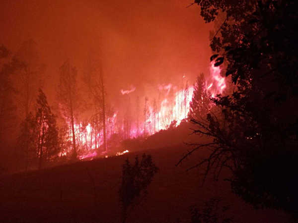
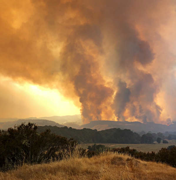
LAKE COUNTY, Calif. – Thursday was another day of hard work on the fire lines for thousands of firefighters trying to stop the advance of the Ranch and River fires, the two incidents that make up the destructive Mendocino Complex that has forced thousands of people from their homes.
By nightfall, Cal Fire said the complex has grown another 15,000 acres, with the day’s-end total at 125,168 acres and containment unchanged at 39 percent.
The Ranch fire made a fierce overnight run toward Bartlett Springs along the footprint of the 1996 Fork fire, totaling 83,890 acres Thursday night, with containment at 33 percent. It grew by 9,000 acres over the course of the day.
Incidentally, the Fork fire itself topped 83,000 acres, making it among the largest fires in Lake County history for its time. However, it’s now likely to be well eclipsed by the time the Ranch has run its course.
The River fire, which grew 6,000 acres Thursday, hit 50-percent containment after burning 41,278 acres by Thursday night, according to Cal Fire.
Resources assigned rose to 3,232 personnel, 402 engines, 58 water tenders, 15 helicopters, 47 hand crews and 51 dozers, Cal Fire said.
The city of Lakeport’s mandatory evacuation order was called off on Thursday afternoon, but much of the city remained empty and businesses closed in the evening, with air quality still rated as very unhealthy or hazardous.
While city residents were cleared to go home, the Lake County Sheriff’s Office issued a mandatory evacuation in the middle of Thursday afternoon for Long Valley and High Valley, as well as for Spring Valley, which was hit in June by the Pawnee fire.
Later on Thursday evening an advisory evacuation notice was issued for areas east of Paradise Valley and west of Sulphur Bank Road on Highway 20 – including all residents living in Glenhaven and Clearlake Oaks.
That notice results in the entire Northshore being in either mandatory or advisory evacuation status. Upper Lake and Nice previously were placed under mandatory evacuation, and Lucerne has remained in advisory evacuation status.
Cal Fire said the complex continues to threaten 8,200 structures.
The agency’s revised damage assessment on Thursday night said 33 structures, among them 16 homes, have been destroyed, while 12 structures, including eight residences, have been damaged.
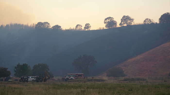
On Thursday evening, firefighters continued to work on building dozer line and structure protection around Scotts Valley and Hendricks roads, where much of the structure damage from the River fire appears to have occurred so far.
Some homes, along with barns and outbuildings have been destroyed, although the Scully Packing shed and the Scotts Valley Women’s Clubhouse – the latter sporting what appeared to be a light pink dusting from retardant – have survived unscathed.
Dozers lines have been cut around homes and buildings, bright yellow fire hose snaked across driveways, and clusters of engines and lead personnel parked along the valley, which was hemmed in by a thick smoke layer.
Firefighters at the scene Thursday said the fire activity was fierce mid-afternoon, and then helicopters began making drops.
One firefighter estimated as many as 40 drops were made by aircraft including a Chinook helicopter, which throughout the evening continued moving back and forth between the fire and a nearby pond with a bucket suspended from a long line.
Reports also have indicated structures have been lost in the Upper Lake area, but so far the Cal Fire reports have not delineated specific addresses.
On the other side of the complex, the Ranch fire has showed no signs of slowing down its progress to the east.
The Ranch fire smoke column continued to push up over the horizon during Thursday evening, rising out of a thick wall of smoke that has settled over much of the county.
Overnight Wednesday and into Thursday, the Ranch fire ran several miles, reaching Bartlett Flat by Thursday morning, according to fire officials.
Henry Wells, whose family owns property at Bartlett Springs, watched the fire’s approach, describing it as a sounding like a freight train, according to his wife, Sherry, who told Lake County News that she spoke with him briefly by phone.
Shortly before 10:30 p.m. Thursday, radio reports from the Ranch fire indicated it was continuing to move toward Colusa County, and making a strong push along a ridge to the north above Long Valley.
Email Elizabeth Larson at