 How to resolve AdBlock issue?
News
The company plans to turn off power to approximately 1,600 customers total in these areas of extreme fire risk:
– Napa County: Portions of unincorporated Napa County and Lake Berryessa;
– Solano County: Portions of Suisun City, and unincorporated areas near Vacaville and Winters;
– Yolo County: Unincorporated areas near Davis and Winters.
In a video released on his Facebook page on Friday afternoon, Sheriff Brian Martin said that he so far had not received any notifications of a potential shutoff for Lake County. The sheriff ensured county residents they would hear from him if conditions changed.
Through its Wildfire Safety Operations Center, PG&E is continuing to monitor weather conditions in parts of the Sierra foothills.
Peak fire risk in these areas is forecasted to begin at around 9 p.m. Saturday and last through roughly noon on Sunday.
A potential PSPS in the Sierra foothills may affect approximately 30,000 customers total in the following areas:
– Butte County: Portions of Paradise, Oroville, Bangor, Forest Ranch, Chico, Berry Creek, Palermo;
– Yuba County: Portions of Browns Valley, Oregon House, Marysville, Wheatland, Rackerby;
– Nevada County: Portions of Auburn, Grass Valley, Smartville, Rough and Ready, Penn Valley;
– El Dorado County: Portions of Pilot Hill, Greenwood, Georgetown, Cool.
– Placer County: Portions of Lincoln.
PG&E said it is working directly with Cal Fire, the California Office of Emergency Services, and other state and local agencies to prepare for these safety events.
On Friday morning, the National Weather Service issued Red Flag Warnings for the Central Valley and the North Bay hills, starting Friday evening or Saturday morning and lasting until Sunday afternoon.
In addition, weather forecasts from PG&E's Wildfire Safety Operations Center showed strong and intensifying winds in the Sacramento Valley and North Bay beginning Friday night into Saturday, with sustained winds between 15 and 30 miles per hour, and local gusts of at least 40 miles per hour. At the same time, northeasterly winds will develop over the Sierra.
After a forecasted Saturday lull, winds are expected to pick back up again beginning Saturday night through Sunday morning along the slopes and foothills of the northern and central Sierra.
After the extreme weather has passed and it is safe to do so, PG&E crews will work to visually inspect each mile of the impacted power lines to ensure they are free from damage and safe to energize.
Inspections will take place during daylight hours and, in most cases, PG&E expects to be able to restore power within 24 to 48 hours after extreme weather has passed.
However, depending on weather conditions or if any repairs are needed, outages – weather event plus restoration time – could last longer than 48 hours. For planning purposes, PG&E suggests customers prepare for multiple-day outages.
Like a winter storm outage, during a public safety power shutoff, outage information, including maps showing which areas may by impacted, will be available on www.pge.com .
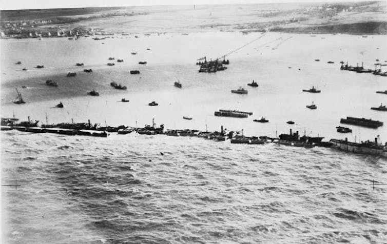 To stage their invasion of Nazi-held France, Allied forces created floating harbors in the English Channel where ships could safely dock to send soldiers and supplies ashore. Royal Air Force
When Allied troops stormed the beaches at Normandy, France on June 6, 1944 – a bold invasion of Nazi-held territory that helped tip the balance of World War II – they were using a remarkable and entirely untested technology: artificial ports.
To stage what was then the largest seaborne assault in history, the American, British and Canadian armies needed to get at least 150,000 soldiers, military personnel and all their equipment ashore on day one of the invasion.
Reclaiming France’s coastline was just the first challenge. After that, Allied troops planned to fight their way across the fields of France to liberate Paris and, finally, onto Berlin, where they would converge with the Soviet army to defeat Hitler.
When Gen. Dwight Eisenhower and his advisers pressed for this ambitious invasion of Nazi-occupied France, British Prime Minister Winston Churchill was dubious.
Could it be done?
Such an operation would require more than a million soldiers – all equipped with weapons, ammunition, food and clothing – plus hundreds of thousands of vehicles, tents and medical personnel.
Getting so many people and materials from ship to shore while battling waves, tides and currents presented an enormous logistical challenge.
Churchill, recalling the failed marine campaign to capture Gallipoli during World War I, feared that Allied troops would get trapped on the beaches and be sitting ducks for the German soldiers awaiting atop Normandy’s cliffs.
So Churchill demanded that a team of engineers, scientists and military officers design a marine staging area that could actually support a successful operation.
The team’s solution was ingenious: two easy-to-assemble artificial ports where Allied ships could safely anchor to stage the massive operation.
As I write in my 2016 book on what became known as the “Mulberry Harbours,” each of these artificial ports consisted of artificial breakwaters – barriers against waves made up of sunken ships and huge concrete chambers.
Behind the circular breakwaters was a sophisticated system of floating piers anchored to the seabed.
All of these parts were towed 30 miles across the English Channel on D-Day from southern England, then sunk into place, about a mile off France’s northwest shore, the same day.
German planes doing air reconnaissance did spot the concrete chambers, which had been filled with air to make them float before they were sunk. But, according to my archival research, they had no idea what they were seeing or how these giant containers would be used.
A floating solution
Once complete, each Mulberry Harbour – a code name that has no deeper meaning – gave Allied troops about 1 square mile of quiet, wave-free ocean from which to stage the invasion.
Nearly 200 military ships and landing crafts anchored at Mulberry Harbours in their first week, sending 12 military divisions, or about 180,000 men, straight into enemy territory.
Ten thousand of them were killed or injured on the first day, blown up by landmines and picked off by camouflaged German machine gun nests and blasted by artillery in concrete bunkers.
On June 19, 1944, a storm permanently disabled the Mulberry Harbour used by the American armed forces.
But Britain’s Mulberry Harbour continued to serve Allied forces for another 10 months as they freed all French ports from German control.
War games in the bath
Churchill became convinced of the merit of the Mulberry Harbours design while in a bath tub on the Queen Mary, as he traveled to Washington to discuss war strategy with President Franklin Roosevelt in 1943.
Churchill’s scientific adviser, Professor John Bernal, floated paper boats in the prime minister’s bathtub, agitating the water to simulate waves, then used a loofah, or sponge, to demonstrate the pacifying effect of breakwaters.
Churchill, who often worked while bathing, saw in that Queen Mary bathtub the answer to the challenge he had issued in the 1942 memo commissioning portable harbors for D-Day.
“They must float up and down with the tide. The anchor problem must be mastered. Let me have the best solution worked out,” Churchill wrote. “Don’t argue the matter. The difficulties will argue for themselves.”
After D-Day, some Mulberry Harbours engineers were sent to the South Pacific with the idea that similar portable ports would be needed for the invasion of Japan. The atomic bombs dropped on Hiroshima and Nagasaki made that unnecessary.
No similar wartime engineering feat has been tried since.![]()
Colin Flint, Distinguished Professor of Political Science, Utah State University
This article is republished from The Conversation under a Creative Commons license. Read the original article.
Reports of wayward black bears are keeping the California Department of Fish and Wildlife's biologists, wildlife officers and other public safety personnel busy across the state this month.
Numerous bears have recently been spotted in urban areas, occasionally requiring human intervention to return them back to wild habitat.
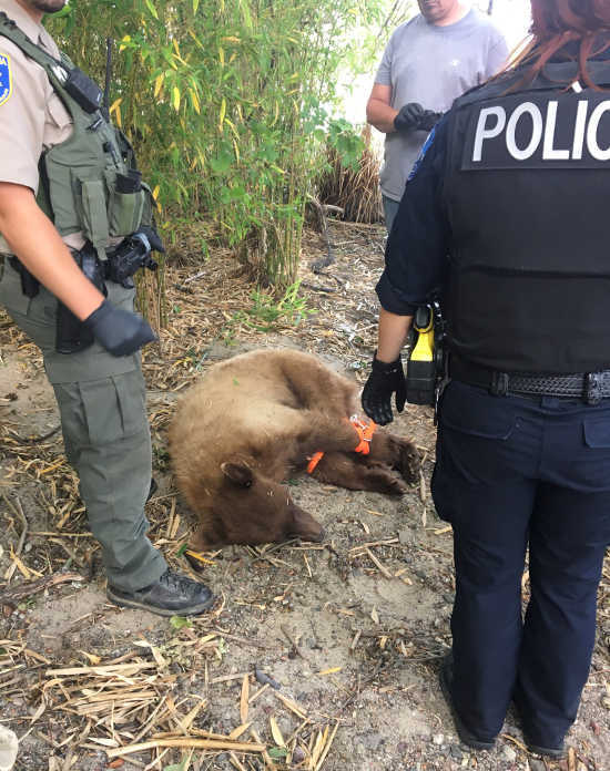
In Lakeport over Memorial Day weekend, police officers worked with wardens to track and tranquilize a bear that later was moved to South Cow Mountain, as Lake County News has reported.
Since then, a bear was safely removed from the University of California, Davis, campus and from a tree in downtown Napa, with a bear also reported in Rohnert Park.
Below are some of the most common questions CDFW has received from the public and members of the media regarding these incidents.
Has there been an increase in the number of bears entering residential areas?
There is a definite uptick in bear activity, which occurs every year around this time, all across the state. In most instances, we're witnessing the dispersal of young male black bears. Young bears typically spend about two years with their mother, after which the mother chases off her young male offspring in the spring to fend for themselves. The behavior itself is not unusual for the time of year.
Nature provides these youngsters with the best chance of survival as they are turned out on their own at a time of year when food and water resources on the landscape are the most available and plentiful.
Black bears typically prefer remote, mountainous areas far away from people. Still, these young, dispersing male bears are learning to survive on their own for the first time and are out seeking new territory to call their own. They sometimes take a wrong turn or end up somewhere they are not supposed to be - in a residential neighborhood or in the middle of town, for instance - at which point CDFW and emergency responders will help return these animals to wild habitat if they can't make it out on their own.
The bear removed from a tree in downtown Napa last week was an adult weighing more than 200 pounds. What was that bear doing?
California's black bears of all ages are waking up hungry from their winter downtime and are out actively searching for food. Adult bears may also be out searching for mates. There is more bear activity across the state this time of year and sometimes the adults end up in the wrong place, too.
The Napa bear stuck up a tree in the middle of the city was there because it was where it felt safest after being scared by his surroundings. The bear might have waited out the day and left undetected at night on his own except that it had been spotted and a large crowd had gathered under the tree. Fortunately, CDFW with help from the local fire department was able to tranquilize the bear, safely remove it from the tree, provide a quick health check, and release it to wild habitat once the tranquilizer drugs had worn off.
Even when bears are spotted in populated and residential communities, the bears will typically and happily find their way back to wild habitat on their own without any kind of assistance. Only when a bear becomes stuck in a situation where it can't escape or is in danger of harming itself or others will CDFW typically intervene to remove the bear and safely return it to wild habitat.
I saw on the news reports about bears in Vacaville and Rohnert Park. Are there really bears in the San Francisco Bay Area?
There are hundreds of thousands of acres of wild habitat in nearby Lake, Solano, Colusa, Sonoma and Napa counties where bears are present. The Knoxville Wildlife Area in Napa County, the lands around Lake Berryessa and the Cache Creek area provide wild habitat for bears and other wildlife. These rugged areas, however, are not that far form population centers in the greater Bay Area where dispersing and foraging bears could accidentally end up.
In some unfortunate cases throughout the state, black bears are being struck and hit by vehicles on the roadways. Drivers need to be particularly alert this time of year as wildlife of all kinds - bears, bobcats, deer, coyotes, foxes, among them - are on the move, out and about, and more active and visible than usual.
Are these bears a public safety threat or a threat to my pets?
Black bears very rarely pose any kind of public safety threat and are not often a threat to domestic dogs and cats. For the most part, they do their very best to stay as far away from people as possible.
What kind of bears are these?
California is home only to one species of bear – the black bear. Black bears, however, come in a variety of colors, including black, brown, blond and cinnamon.
How can I help the bears?
Bears have a highly specialized sense of smell. The public can help bears stay out of human settlements and stick to their natural diet by properly disposing of leftover food and garbage and securing other attractants such as pet food so these dispersing bears don't become acclimated to urban environments. CDFW's Keep Me Wild: Black Bear webpage offers a number of other useful tips to keep the bears wild and safe.
Who should I call to report a bear?
A black bear spotted while out hiking, camping or recreating in wild habitat is not necessarily a cause for alarm. Bears spotted in residential, suburban or urban areas should be reported to the nearest CDFW regional office during normal business hours. After-hours or weekend sightings should be reported first to local police or sheriff officers, who often can respond and secure a scene quickly and then contact CDFW as needed. In any kind of emergency situation, please call 911.
More than a trillion new measurements of Earth’s height – blanketing everything from glaciers in Greenland, to mangrove forests in Florida, to sea ice surrounding Antarctica – are now available to the public.
With millions more observations added each day, data from NASA’s Ice, Cloud and land Elevation Satellite-2 is providing a precise global portrait of elevation and will allow scientists to track even the slightest changes in the planet’s polar regions.
“The data from ICESat-2 are really blowing our minds, and I’m really excited to see what people with different perspectives will do with it,” said Lori Magruder, a senior research scientist at the University of Texas, Austin, and the ICESat-2 science team lead.
The long-awaited ICESat-2 mission, launched in September 2018, continues the record of polar height data begun with the first ICESat satellite, which operated from 2003 to 2009. NASA’s airborne Operation IceBridge project bridged the data gap between the two satellites.
The new satellite provides far more measurements than its predecessor. ICESat took approximately 2 billion measurements in its lifetime, a figure ICESat-2 surpassed within its first week.
When ICESat orbited over a rift in Antarctica’s Filchner-Ronne Ice Shelf in October 2008, for example, it recorded a handful of data points indicating a crevasse in the ice. When ICESat-2 passed over 10 years later, it collected hundreds of measurements tracing the sheer walls and jagged floor of the growing rift.
ICESat-2 is taking these measurements in a dense grid across the Arctic as well as Antarctica, recording each spot every season to track both seasonal and annual changes in ice.
ICESat-2’s ability to measure heights beyond the poles is also impressing scientists – Magruder pointed to coastal areas, where in clear waters the satellite can detect the seafloor up to 100 feet (30 m) below the surface. Over forests, the satellite not only detects the top of the canopy, but the forest floor below – which will allow researchers to calculate the mass of vegetation in a given area.
All this is being done with six laser beams from a satellite 310 miles (500 kilometers) in space, noted Tom Neumann, ICESat-2 project scientist at NASA’s Goddard Space Flight Center in Greenbelt, Maryland.
“Getting the exact latitude, longitude, and elevation of where a photon bounced off Earth is hard – lots of things have to happen and go really, really well,” he said. To make sure everything is working, the science team conducts a series of checks using data from airborne surveys, ground-based campaigns, even the satellite itself.
That includes scientists travelling to Antarctica, where they drove modified snow-groomers along an arc of the 88-degree-south latitude line, taking highly accurate elevation measurements to compare with the data collected by ICESat-2 in space. Magruder compared measurements taken in White Sands, New Mexico, with what the satellite was tracking.
In its most recent Antarctic and Arctic campaigns, NASA’s airborne Operation IceBridge flew specific routes designed to take measurements over the same ice, at close to or exactly the same time the satellite flew overhead.
ICESat-2 is designed to precisely measure the height of ice and track how it changes over time. Earth’s melting glaciers cause sea levels to rise globally, and shrinking sea ice can change weather and climate patterns far from the planet’s poles.
Small changes across vast areas like the Greenland ice sheet can have large consequences. ICESat-2 will be able to measure the shift in annual elevation across the ice sheet to within a fraction of an inch. To do this, the satellite uses a laser altimeter – an instrument that times how long it takes light to travel to Earth’s surface and back.
With that time – along with the knowledge of where in space ICESat-2 is, and where on Earth the laser is pointing – computer programs create a height data point. The data is originally processed at NASA Goddard, then turned into advanced data products that researchers will be able to use to study elevations across the globe.
ICESat-2 data products are now available for free from the National Snow and Ice Data Center at https://nsidc.org/data/icesat-2 .
For more information, visit www.nasa.gov/content/goddard/icesat-2 or https://icesat-2.gsfc.nasa.gov/ . For more information on the data products, visit https://earthdata.nasa.gov/icesat-2-data .
Kate Ramsayer works for NASA's Goddard Space Flight Center, Greenbelt, Maryland.
CLEARLAKE, Calif. – A former Clearlake City Council member who left the council last year to pursue the city’s police chief job has been selected to fill the vacancy left by Mayor Nick Bennett’s May resignation.
During a special Thursday afternoon meeting, the council voted 4-0 to appoint Russell Perdock to fill Bennett’s term, which lasts another 18 months.
Bennett resigned on May 9 citing health reasons, moving later in the month to South Dakota, as Lake County News has reported.
The council subsequently decided to fill the vacancy by appointment rather than holding a special election in March 2020.
The council established an application period of nearly a month, and six city residents applied for the vacant seat.
The discussion begins in the video above at the 28:50 mark.
In addition to Perdock, Cristina Azanza, David Claffey, Desserrie Shaw, Erin McCarrick and Pattie Duke submitted applications.
During Thursday’s meeting, the council interviewed five of the six, as Shaw did not attend.
Perdock served more than three years on the council before resigning in February 2018 to apply for the city’s police chief’s post, which later went to Andrew White.
He ran for council last year, coming in third in a three-person field, with Russell Cremer and Dirk Slooten winning the two available seats.
Perdock, who now works for Adventist Health Clear Lake as director of community integration, told the council that he wanted to again be part of helping the city move forward in a position direction. He added that he doesn’t see himself as a politician but as a public servant.
After posing questions to the candidates about their work and educational history, interests and abilities, the council took public comment, with several people – including former mayor, Denise Loustalot – speaking in favor of appointing Perdock because of his experience and their belief in his ability to quickly get up to speed.
Councilmembers, in turn, voiced their support, but Slooten said he wanted to make sure Perdock didn’t quit halfway through the term for another police-related job.
The other applicants were encouraged to get involved with city government, including running for a seat in the next election.
Councilman Phil Harris moved to approve Perdock’s appointment, with Joyce Overton seconding and the council voting 4-0.
City Clerk Melissa Swanson said Perdock will be sworn in at 4 p.m. Thursday, June 13, ahead of the budget workshop that will precede the regular meeting.
City Manager Alan Flora urged Perdock to pick up his budget book before he left City Hall Thursday evening.
Police radio infrastructure upgrades approved
Also on Thursday, Clearlake Police Chief Andrew White received the council’s approval for the purchase of radio equipment and a contract for installation services from Precision Wireless Service, in an amount not to exceed $63,543.
White explained that his department’s public safety radio system needed to be replaced, as it has had multiple failures, is at the end of its service life and poor “talk-in” coverage – which relates to transmissions from field units to dispatch and other units.
White explained that the police department utilizes two-way radio as the primary means to communicate with field personnel in both emergency and non-emergency situations. The system’s equipment and antennas have repeatedly failed.
He said the current system uses a repeater which has antennas fixed to a wooden pole outside of the police department.
The equipment’s performance is jeopardizing officer and community safety, with White explaining that critical incident situations have happened and the radios haven’t worked.
Five years ago, the department added a backup repeater at Adventist Health Clear Lake, but that hasn’t solved the problem, so last summer the agency began looking into a new radio system, White said.
White said they’ve opted to go with a “voted” radio system, which uses an electronic device called a “comparator” that compares the signals received from multiple receive sites in a coverage area and then passes the best signal to the repeater to transmit to other units and dispatch. Such a system eliminates the need for an officer to change channels on their radio.
The updated system will have three initial equipment sites – the police department, the hospital and a new location on Woods and Eureka Avenue owned by the Konocti Water District. A contract will need to be developed for the third site, White explained.
White played some audio from police incidents to illustrate the scope of the problem, with the transmissions barely understandable. One recording came from earlier on Thursday, when five officers needed to subdue a combative subject and the radio transmission was so poor other officers couldn’t use it to locate the incident – that was done by computer tracking.
Sgt. Martin Snyder, Officer Mark Harden and Capt. Tim Celli all spoke to the council in support of the new equipment.
Celli, who has been with the department since 1995 – the longest of any police employee – said the radios have been a longtime issue. “This seems like a really good option for us,” he said, noting he can tell the council many stories of officers calling for help over the faulty equipment.
He said the officers put their lives on the line every day, and they need to be given the best equipment possible.
Snyder, who emphasized safety concerns, said the new system is not conventional and it’s expandable.
Harden said during a fire in the Avenues a few years ago, the radios quit working as officers were conducting evacuations. During the October 2017 Sulphur fire, officers couldn’t hear the operations center over the radios and had to use portables, which didn’t allow them to communicate as they were trying to evacuate residents. Cell phones had to be used instead.
During a deadly force encounter in which someone was trying to stab Harden with a screwdriver, he said he couldn’t be heard on the radio and instead used it like a distress code, which other officers recognized. He said that, once out of their cars, the officers are failed by the system.
“Your safety is definitely the highest things in our minds. Know that,” said Mayor Russ Cremer.
Cremer asked if the purchase is in the 2019-20 budget. Flora said no. Because they feel that it’s critically important to do it now, Flora said the city would fund the equipment purchase from salary savings in the current year’s police budget.
Harris moved to approve the equipment purchase, which the council approved 4-0.
Email Elizabeth Larson at
060619 Clearlake City Council special meeting agenda packet by LakeCoNews on Scribd
The White House said Thursday that President Trump signed into law H.R. 2157, the “Additional Supplemental Appropriations for Disaster Relief Act of 2019.” The president is reported to have signed the bill on Air Force One, while traveling in Europe.
The bill will provide $19.1 billion “to help Americans recover from the catastrophic disasters that have struck the nation in the past three years,” the White House reported.
HR 2157 includes:
– $4.5 billion to the Department of Agriculture for agricultural-related losses, emergency timber restoration, farmland repair and watershed recovery work to help American farmers and ranchers. That amount includes $720 million for the U.S. Forest Service to strengthen forest management efforts.
– $3.3 billion for the Corps of Engineers to repair damage caused by natural disasters, to invest in new flood and storm damage reduction projects, and to make the nation more resilient to future natural disasters. That includes $1 billion funding to address 2018 and 2019 floods, which could provide critical support in Lake, Glenn, Butte and Colusa counties.
– $349.4 million to repair local drinking water systems – including the water system in Paradise, destroyed by the 2018 Camp fire.
– $1.6 billion to the Department of Transportation for the Federal Highway Administration’s Emergency Relief Program and additional resources for wildfire suppression activities conducted by the United States Forest Service.
It also reauthorizes the National Flood Insurance Program through Sept. 30.
“President Trump is committed to securing funding for and improving the implementation of policies that mitigate the risk natural disasters pose to communities and make the Nation’s recovery from disasters vastly more effective,” the White House signing statement said.
"I want to thank President Trump and Congress for bringing much-needed relief to communities impacted by wildfires and other natural disasters. This legislation will bring our state critical disaster funding to help Californians rebuild and recover,” said Gov. Gavin Newsom.
The bill had the staunch support of both of Lake County’s members of the House of Representatives.
Mike Thompson – representing the Fifth Congressional District, including the southern half of Lake County – and John Garamendi, whose Third Congressional District covers the county’s northern portion, had both voted for the bill and urged the president to sign it.
The bill passed the House of Representatives in a 354 to 58 vote and the Senate by 85 to 8.
Thompson’s office reported that the bill had involved a “lengthy negotiation process,” and that it includes key provisions to help North Bay wildland fire disaster recovery efforts.
In a statement issued earlier this week following Congress’ passage of the bill, Thompson said the legislation “includes critical funding to help our district recover from recent fires, provisions I fought to include to help us recover and rebuild.”
Those provisions include $100 million in Community Development Block Grant funding that can be used to help communities with unmet needs. “That will allow us to continue with debris removal, funding housing and repair infrastructure that was damaged in the October 2017 fires. The bill also includes funding to help small family agricultural producers whose crops were damaged by disaster like the wildfires and wildfire smoke in our district,” Thompson said.
More specifically, Thompson’s office said the bill includes funding to help Lake County grape growers whose crops were damaged by the Mendocino Complex fires.
“Natural disasters fueled by climate change have wreaked havoc on nearly every corner of the United States in recent years,” Garamendi said. “This legislation provides critical services to help communities recover from recent disasters and to prepare for any similar events in the future.”
Garamendi said he was proud to work with his colleagues in the California Congressional delegation to secure presidential approval of Gov. Newsom’s major disaster declaration, as well as his work with Thompson to extend USDA’s Wildfire and Hurricane Indemnity Program to cover crop losses stemming from the 2018 and 2019 natural disasters, including California winegrape growers with smoke-tainted grapes from fires.
Email Elizabeth Larson at