How to resolve AdBlock issue?
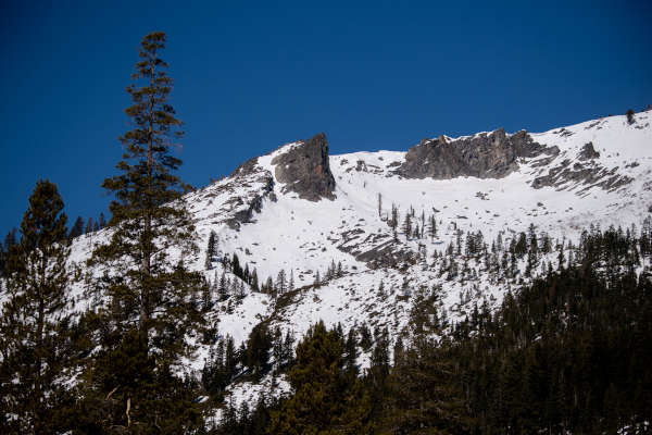
Snowpack measurements across California continue to show below-normal depth, a concern because of the amount of water supply stored in mountain snow.
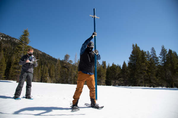
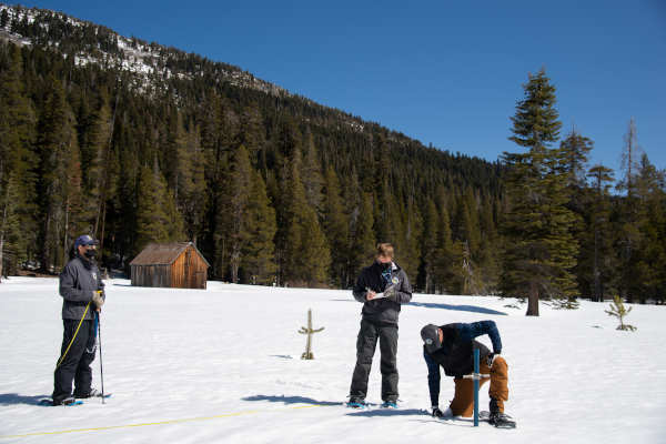
The Department of Water Resources on Thursday conducted the fourth snow survey at the Phillips Station snow course.
The manual survey recorded 49.5 inches of snow depth and a snow water equivalent, or SWE, of 21 inches, which is 83 percent of average for this location. The SWE measures the amount of water contained in the snowpack and is a key component of DWR’s water supply forecast.
Measurements from DWR’s electronic snow survey stations indicate that statewide the snowpack’s SWE is 16.5 inches, or 59 percent of average for the date. April 1 is typically when California’s snowpack is the deepest and has the highest SWE.
“While there is some snow on the ground today at Phillips Station, there is no doubt California is in a critically dry year. State agencies, water suppliers and Californians are more prepared than ever to adapt to dry conditions and meet the challenges that may be ahead,” said DWR Director Karla Nemeth. “With climate change impacting how precipitation falls in California, ongoing water efficiency and long-term efforts like recycling water, capturing stormwater, and planting water-friendly landscapes are essential to securing California’s water future.”
While the Southern Sierra remains well below average for both rain and snow, the picture is somewhat different in the Northern and Central part of the state where California typically receives 75 percent of the State’s annual precipitation.
The few storms that impacted California this year have been colder, bringing more snow than rain.
This is a positive sign for the Sierra snowpack which accounts for 30 percent of California’s fresh water supply in an average year.
In the Mendocino National Forest, snowpack levels also are below normal.
DWR’s California Data Exchange Center shows that the 6,200-foot Anthony Peak, located in the Stony Creek river basin on the forest’s Covelo Ranger District, recorded 24 inches of depth and 11 inches of water content, for a density of 46 percent as of March 30. That’s up from the 32 percent density recorded at the site at the end of March 2021.
At Plaskett Meadows, located at 6,000 feet elevation on the Eel River basin, recorded snow depth of 10 inches and 4.5 inches of water content for a density of 45 percent on March 31, compared to 42 percent density in a year-over comparison.
For Water Year 2021, the snowpack in the Northern and Central Sierra peaked at 70 percent of average, however rain is below 50 percent of average, which ties this year for the third driest year on record.
The severity of dry conditions is particularly evident in the Feather River watershed where water levels at Lake Oroville, the State Water Project’s largest reservoir, are currently at 53 percent of average.
Statewide, following a below-average 2020 water year, California’s major reservoirs are at just 50 percent of overall capacity. The amount of water expected to enter California’s reservoirs when the snowpack melts is projected to be just 58 percent of average.
With dry conditions continuing to impact California’s water supply, DWR recently announced an adjustment to the State Water Project allocation for 2021. The department now expects to deliver 5 percent of requested supplies this year, down from the initial allocation of 10 percent announced in December.
Officials said California is better prepared for drought than in the past. Following the 2012-2016 drought, DWR enacted many programs focused on managing the state’s water through a strategic, integrated approach with a strong emphasis on water use efficiency and conservation. The state provides assistance and tools to local water agencies to help them reduce their drought vulnerability.
DWR’s Water Use and Efficiency Branch provides agencies and individuals with assistance for improving water use efficiency and developing and meeting efficient water use requirements.